 Abandoned

Overview
A Yukon name in the Aravaipa Valley

Klondyke sits on the floor of the Aravaipa Valley in western Graham County, with the Galiuro Mountains to the southwest and the Santa Teresa Mountains to the north. It lies about 32 miles down a dirt road from US 70. Miners back from the Klondike gold rush in Canada's Yukon are said to have settled here around 1900 and named the place for the goldfields they had left. Why they spelled it with a y isn't recorded.
The town lived on lead and silver mines in the nearby hills and on the cattle ranches of the valley. At its height it had about 500 people, two stores, a stamp mill, a saloon, a church, a post office that opened in 1907, and a school that at one time had more than 30 pupils. The Depression took about half the town, and the post office closed in 1955.
Klondyke never emptied completely. Wikipedia puts the population at about a dozen. In 2026 Arizona Highways found a handful of occupied homes, the 1907 schoolhouse recently rehabilitated, and the old adobe store open again after years closed. Most visitors pass through on the way to the east end of Aravaipa Canyon, a BLM wilderness about eight miles farther on. On a hill southeast of town is the cemetery where the Power family lies. Their 1918 gunfight with a Graham County posse, at a cabin in the Galiuro Mountains, left four men dead.
Timeline
From homestead valley to near-ghost town
- Epimenio Salazar homesteads in the Aravaipa Valley. His family stays for generations.
- The Army forces the Apaches of the region onto reservations. Ranchers, farmers and miners follow.
- Miners back from the Klondike gold rush settle here and name the place Klondyke. Arizona Highways dates the founding to the 1890s.
- By Wikipedia's account, a Mr. Bedoya replaces his tent store with a wooden store and a saloon.
- The post office opens. The schoolhouse that still stands dates from the same year.
- The Power family arrives from Texas and homesteads in the Galiuro Mountains south of town.
- Ola May Power dies. The coroner records an unknown cause.
- A posse from Klondyke tries to arrest the Power brothers at their cabin. Three lawmen and Jeff Power are killed.
- An Army cavalry patrol captures John and Tom Power and Tom Sisson after they cross into Mexico.
- The Depression takes about half of the town's people.
- The post office closes.
- The Power brothers are paroled after 42 years in prison. They're pardoned in 1969.
- Power's Cabin is listed on the National Register of Historic Places.
- John Power dies and is buried in the Klondyke cemetery near his father.
- The general store closes, according to Southern Arizona Guide.
- Arizona Highways reports the adobe store open again after years closed.
Record and family story
The Power shootout, 1918

The Power family came to Arizona from Texas in 1909 and ranched and mined in the Galiuro Mountains south of Klondyke. By 1917 Jeff Power, his sons John and Tom and a family friend, Tom Sisson, were working an old gold claim in Keilberg Canyon and living in a cabin above it. In December Jeff's daughter, Ola May, died. The coroner recorded an unknown cause.
The United States had entered World War I, and John and Tom were accused of dodging the draft. On February 9, 1918, Graham County Sheriff Frank McBride, his deputies Martin Kempton and Kane Wootan, and Deputy U.S. Marshal Frank Haynes drove from Klondyke to the Upchurch Ranch, borrowed horses and reached the cabin that night. Shooting broke out at dawn on February 10. Within minutes McBride, Kempton and Wootan were dead and Jeff Power was mortally wounded. Haynes, the only survivor of the posse, rode back to Klondyke.
The brothers and Sisson fled south. Posses failed to catch them, in what Wikipedia calls the largest manhunt in Arizona's history up to then. An Army cavalry patrol picked up their trail and took them without a fight on March 8. All three were convicted of first-degree murder. Sisson died in prison in 1957. John and Tom served 42 years before their parole in 1960, and Governor Jack Williams pardoned them in 1969.
Haynes said the first shots came from inside the cabin. The brothers said the posse shot their father as he stood in his doorway with his hands up.
The brothers' version is the one carved in stone. Jeff Power's headstone in the Klondyke cemetery reads "Shot down with his hands up in his own door." Ola May's says she was poisoned by an unknown person, while another account says the family blamed a rattlesnake bite. Neither claim was ever proved, so read the gravestones as the family's side of the story. The cemetery also holds Jeff's mother, Martha Jane, killed in 1915 when her horse and buggy ran away. Some accounts call her his wife. Tom Power died in 1970 and John in 1976, and both are buried here.
A popular story holds that Klondyke's spelling was a mistake by founders who couldn't spell. Arizona Highways says the reason, if there ever was one, has been lost. Treat the misspelling tale as a joke that stuck.
What's left
A store, a schoolhouse and a hillside cemetery
Klondyke is a scatter of homes at a crossroads near Aravaipa Creek. The adobe general store dates to the early 1900s. It was closed for years and was open again as of mid-2026. The schoolhouse dates to 1907 and was recently rehabilitated. The BLM's Klondyke Ranger Station is at the north end of the settlement, and its Fourmile Canyon Campground is about a mile southwest, with 10 first-come sites at $5 a night, a toilet and no water.
The cemetery stands on a hill southeast of town, on private property. An older Arizona Highways story advised asking at the ranch house before walking up to the graves, and that's still the polite way to do it.
The historic maps further down show how little the place has changed in size. The 1938 sheet draws a tight cluster of buildings at the crossroads beside Aravaipa Creek, with fenced fields along Klondyke Wash. The 1943 sheet marks the Crook National Forest boundary just southwest of town. By 1972 only a few buildings appear, with Klondyke Cemetery to the southeast. The 1986 sheet adds a landing strip north of town and the Quinn Mine in the hills to the east.
- Adobe general store (early 1900s)
- Schoolhouse (1907)
- Occupied homes
- BLM Klondyke Ranger Station
- Klondyke cemetery (private): Power family graves
- Fourmile Canyon Campground (BLM)


Beyond Klondyke
The road to Aravaipa Canyon

Past Klondyke, the road becomes Aravaipa Canyon Road and ends about eight miles on at the East Trailhead of the Aravaipa Canyon Wilderness. The BLM wilderness covers 19,410 acres around an 11-mile canyon cut through the Galiuro Mountains, and Aravaipa Creek runs through it all year. You need a BLM permit to hike, backpack or hunt in the canyon or any side canyon. Reserve it in advance on recreation.gov. The stay limit is three days and two nights, and there are no trails or facilities inside.
As of October 16, 2026, Recreation.gov reports that Hurricane Polo badly damaged the road to the east wilderness boundary. It's closed to vehicles past the East Aravaipa Trailhead at Bear Canyon, and from there you walk 1.9 miles along the road to reach the boundary.
Along the road to the trailhead, The Nature Conservancy's Aravaipa Canyon Preserve asks visitors to stay on the road. Camping, fires, dogs and drones are not allowed on its land, and walking onto the preserve needs permission from its staff. The Salazar Family Church, built in the early 1900s by one of the canyon's first families, stands less than a mile before the trailhead. Turkey Creek, a free primitive campsite, is near the wilderness entrance.
Power's Cabin is a separate trip. It stands far to the south in the Galiuro Wilderness of the Coronado National Forest, where no vehicles are allowed, and Southern Arizona Guide describes the hike in on the Powers Garden Trail. The Forest Service restored the cabin after its listing on the National Register in 1975.
Historic maps
Klondyke on USGS maps, 1938–1998
Crops from the USGS Historical Topographic Map Collection, centered on the townsite. Each sheet shows what surveyors mapped that year; compare them with today's topo and aerial on this page.
Day trip
Plan a day trip to Klondyke from Safford
Take it with you
Day trip itinerary
The essentials, the sample day with boxes to tick, what to photograph and the coordinates, on two printable pages. Handy where there's no signal.
Download the PDF (643 KB)Klondyke is a long way down a dirt road, about an hour and 40 minutes from Safford, so plan a full day and bring what you need. In town, the store, the schoolhouse and the cemetery make a short stop. Most visitors come for Aravaipa Canyon, and hiking there takes a permit booked ahead.
A sample day
- Leave Safford west on US 70 through Thatcher and Pima, and turn left on Klondyke Road. The pavement ends within the first mile.
- Reach Klondyke. See the adobe store and the 1907 schoolhouse, and ask before walking up to the cemetery where the Power family lies.
- Continue on Aravaipa Canyon Road to the East Aravaipa Trailhead at Bear Canyon. Drive slowly through the creek crossings.
- With a permit, walk the 1.9 miles of closed road to the wilderness boundary and on into the canyon. Without one, turn back and picnic at Fourmile Canyon Campground.
- Start back. It's about 1 h 40 min from Klondyke to Safford, plus the drive out from the trailhead.
From Tucson, the routed drive by way of Bonita takes about 3 h 35 min each way, too long for a day trip. Stay in Safford, or camp at Fourmile Canyon, where 10 first-come sites cost $5 a night.
What to photograph and film
- The adobe store and schoolhouse. Klondyke's two landmarks. Shoot them from the road and keep occupied homes out of the frame.
- The Power headstones. Jeff Power's stone reads "Shot down with his hands up in his own door." Ask first, and photograph the inscriptions without touching the stones.
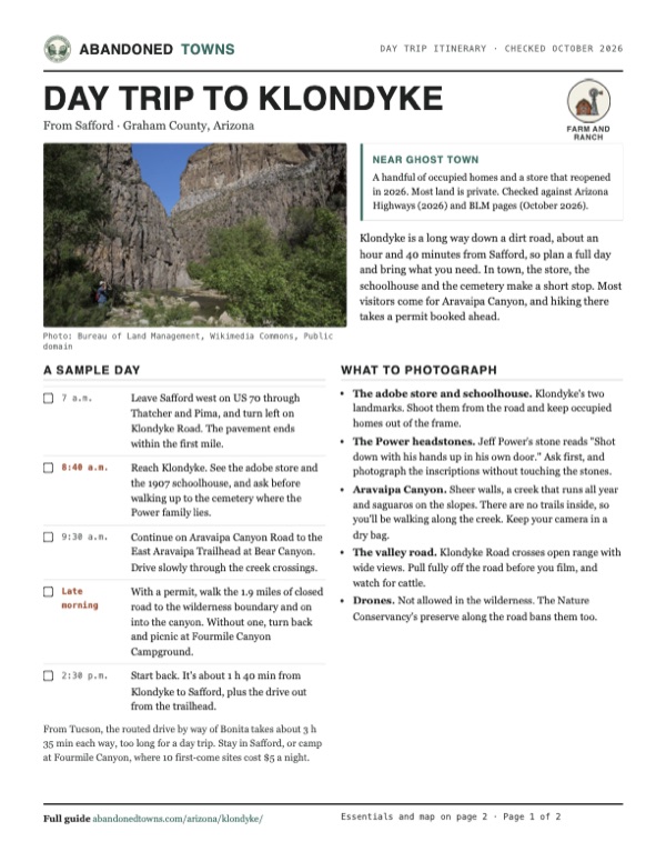
- Aravaipa Canyon. Sheer walls, a creek that runs all year and saguaros on the slopes. There are no trails inside, so you'll be walking along the creek. Keep your camera in a dry bag.
- The valley road. Klondyke Road crosses open range with wide views. Pull fully off the road before you film, and watch for cattle.
- Drones. Not allowed in the wilderness. The Nature Conservancy's preserve along the road bans them too.
Map & directions
Getting there
Safford is the closest city with services. From there, US 70 runs northwest through Thatcher and Pima to Klondyke Road, which is dirt nearly all the way to town. From Tucson, the routed approach runs east on I-10 and comes in from the south through Bonita. Both routes end on Klondyke Road.


Base map: USGS The National Map (public domain). Routes: OSRM on © OpenStreetMap contributors data (ODbL), computed October 2026. Times assume dry roads.
- From downtown Safford, take Main Street west and 8th Avenue north to US 70 (Thatcher Boulevard).0.6 mi
- Follow US 70 northwest through Thatcher and Pima.14.4 mi
- Turn left onto Klondyke Road. The pavement ends within the first mile. At the Y at about mile 25, where Bonita-Klondyke Road goes left, keep right on Klondyke Road down into the Aravaipa Valley to Klondyke.32.2 mi
- From downtown Tucson, take Congress Street to I-10 and head east past Benson and Willcox.94.4 mi
- Take the exit for US 191 and turn left, north, on US 191.17.2 mi
- Turn left onto AZ 266 and follow it west to Bonita, where the pavement ends.19.2 mi
- Continue on Bonita-Klondyke Road, dirt, northwest down the Aravaipa Valley.22.9 mi
- Go straight onto Klondyke Road at the signed junction and follow it to Klondyke.7.5 mi
Road and safety notes
- Arizona Highways (2026) calls Klondyke Road a wide, smooth dirt road that most vehicles can handle in good weather. Past Klondyke it gets rougher and more rutted, with shallow crossings of Aravaipa Creek, and needs high clearance. Four-wheel drive isn't needed in good weather.
- The BLM warns that the road to the East Trailhead crosses the creek with no bridges and is often impassable after flash floods. Klondyke and Aravaipa roads can also be muddy, slippery or icy in season. Call the BLM Safford Field Office, 928-348-4400, for conditions.
- Fill up and carry water in Safford or Pima. The Klondyke store was closed for years before 2026, and Arizona Highways has long described it as the only business in the area.
- Hurricane Polo damage has closed the road to vehicles past the East Aravaipa Trailhead at Bear Canyon, 1.9 miles short of the wilderness boundary (Recreation.gov, October 16, 2026).
- This is open range. Cattle graze close to the road, so drive slowly.
- The cemetery, homes and the schoolhouse are on private land. Ask before you walk in, and respect gates and signs.
Photos
Klondyke and its canyon country
Visitor reports
Been to Klondyke?
Been there lately? Tell the next visitor what you found: whether you could get in, the state of the road and what's still standing. Photos are welcome. We read every report before it appears here.
Farm and ranch
More farm and ranch ghost towns
The nearest in Arizona.

 Guide
Redington
32.43, -110.49Pima County, Arizona
A ranching settlement founded in 1875 on the San Pedro River, with a store, a post office and a school. What's left lies inside a working family…
 Guide
Cascabel
32.29, -110.38Cochise County, Arizona
A ranching settlement on the lower San Pedro River that lost its post office in 1936 but never lost its people. Its name, by the standard account…
Nearby
Other sites near Klondyke
Straight-line distance from the townsite to other mapped sites in our Arizona index.
Sources
Sources and credits
- ghosttowns.com, "Klondyke": fact sheet fields (county, roads, legal description, climate, best time).
- Wikipedia, "Klondyke, Arizona", retrieved October 2026: founding, mines, store history, post office dates, population, coordinates.
- Wikipedia, "Power's Cabin shootout", retrieved October 2026: the Power family, the posse, the shootout, capture, sentences, parole and pardon, the 1975 listing.
- Arizona Highways, "Klondyke Road" (2026): the store open again as of mid-2026, the 1907 schoolhouse, the private cemetery, road surface, mileages and vehicle advice, permits.
- Arizona Highways archive, Sam Negri, "Back Road Adventure": the Power headstones and their inscriptions, the advice to ask at the ranch house.
- Arizona Highways archive, Tom Dollar, "Back Road Adventure": the Salazar homestead, the 1873 removal, Klondyke's stores, stamp mill and school, open range.
- Arizona Highways archive, Gregory McNamee, "Bonita to Klondyke": the Bonita approach, the junction 7.5 miles from town, seasonal road conditions.
- BLM, Aravaipa Canyon Wilderness and Fourmile Canyon Campground, as of October 19, 2026: permits, stay limit, East Trailhead road, campground sites and fees, ranger station.
- The Nature Conservancy, Aravaipa Canyon Preserve, as of October 2026: preserve rules, Turkey Creek campsite.
- Southern Arizona Guide, "Klondyke": the store closing in 2005, the rattlesnake account of Ola May's death, the Powers Garden Trail to the cabin.
- Recreation.gov, Aravaipa Canyon Wilderness permit, as of October 19, 2026: day-hike permits, fees, booking window, pet and drone rules, the Hurricane Polo road closure and the October 16, 2026 reopening of the East Aravaipa Trailhead. BLM, Aravaipa permits: permit rule, no pets.
- Wilderness acreage and canyon length: BLM photo descriptions on Wikimedia Commons. Elevation: USGS 3D Elevation Program point query. Routes: OSRM on OpenStreetMap data, October 2026.
Photo and map credits
- A hiker in Aravaipa Canyon, the wilderness beyond Klondyke: Bureau of Land Management, Wikimedia Commons, Public domain
- Power's Cabin in the Galiuro Mountains, scene of the 1918 shootout: USFS, Wikimedia Commons, Public domain
- The Klondyke general store in 1910: Unknown photographer, Wikimedia Commons, Public domain
- Aravaipa Creek and saguaros from the canyon slope: Bureau of Land Management, Wikimedia Commons, Public domain
- Evening light on the walls of Aravaipa Canyon: Bureau of Land Management, Wikimedia Commons, Public domain
- Klondyke on the 1938 USGS Klondyke sheet: U.S. Geological Survey, USGS catalog, Public domain
- Topo map, area base map and aerial imagery: USGS The National Map (public domain).
- Historic maps: USGS Historical Topographic Map Collection (public domain): Klondyke 1938, 1:48,000; Klondyke 1943, 1:62,500; Klondyke 1972, 1:24,000; Mammoth 1986, 1:100,000; Klondyke 1998, 1:24,000.