 Abandoned

Overview
The Silver King's mill town

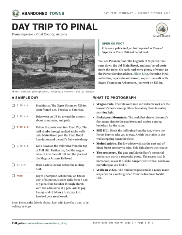
Pinal grew up around a mill. In 1875 prospectors found rich native silver on a small hill in the Pinal Mountains foothills and staked the Silver King claim. In June 1876 a stamp mill for its ore went up about five miles to the southwest, on Queen Creek, one of the few places nearby with reliable water. It stood on the site of an Army road camp General Stoneman had used in 1870 and 1871. The camp was called Picket Post, the same name as the mountain above it, and the new town took that name too. Its post office opened in 1878 and was renamed Pinal in 1879.
For about ten years Pinal did well. Mule teams hauled Silver King ore down to its mills, and by the mid-1880s it had an official population of over 800, with hotels, banks, breweries, saloons, stores and a newspaper, the Pinal Drill. Other accounts put the town at 2,000, and one history says it claimed 2,500 people and 123 buildings. Over its life the Silver King produced about 6.2 million ounces of silver.
The rich ore ran out in the late 1880s, just as silver prices fell. Milling stopped in early 1889, the town emptied, and the post office closed in November 1891. Some residents moved to Hastings, a few miles east, which grew into the copper town of Superior. Today the Legends of Superior Trail runs along Pinal's old Main Street, past foundations, a tailings pile, mill ruins and wagon ruts cut into soft volcanic rock.
Timeline
From Army camp to trailside ruins

- General George Stoneman sets up a small Army camp, Picket Post, on Queen Creek near the foot of Picket Post Mountain and starts a road east into the Pinal Mountains. The troops are gone by August 1871.
- Prospectors stake the Silver King claim on a small hill about five miles to the northeast. Its ore is rich native silver.
- A stamp mill and amalgamation plant for Silver King ore go up beside the old camp, one of the few spots nearby with reliable water.
- A post office opens under the name Picket Post.
- The post office is renamed Pinal. The Forest Service's trail brochure dates the change to 1878.
- The Southern Pacific reaches Casa Grande, cutting the cost of hauling supplies to the district.
- The town's paper, the Pinal Drill, is in its second volume.
- The easy silver ore is running out. Ore is now crushed at the mine and hauled by wagon to Pinal, where 20 stamps and 12 Frue vanners turn it into concentrate for smelters in California and Omaha.
- Pinal has an official population of over 800, with hotels, banks, breweries, saloons and stores.
- The Silver King's last profitable year.
- Celia Ann "Mattie" Blaylock, Wyatt Earp's former common-law wife, dies at Pinal of a laudanum and alcohol overdose.
- Milling at Pinal stops, and the townsite is abandoned soon after.
- Ten stamps from the idle Pinal mill are moved to the Silver King for a short-lived revival.
- The post office closes.
- Superior's Fairview Cemetery opens, and burials at the old Pinal cemetery end.
- The old Pinal cemetery is fenced and gets new signs.
- The Legends of Superior Trail crosses the townsite, with numbered posts keyed to a Forest Service brochure.
- The trail group's website says all five segments of the trail are open.
Record and uncertainty
The cemetery and Mattie Earp


Pinal's dead were buried in what is now called the Historic Pinal Cemetery. Sources date it to 1876 or 1878. Wikipedia counts 43 identified graves, and most are marked only by rings of stones. People from Superior kept using it until 1916, when Fairview Cemetery opened in town. Tonto National Forest administers it. It was fenced in 2009 and is protected under the Archaeological Resources Protection Act.
Its best-known grave belongs to Celia Ann "Mattie" Blaylock. She had been Wyatt Earp's common-law wife, and after he left her she ended up in Pinal. She died there on July 3, 1888, from laudanum and alcohol, and the death was ruled suicide by opium poisoning.
A marker reading "Celia Blaylock aka Mattie Earp" stands in the cemetery, but at least one recent account says the exact grave has been lost and the marker is a memorial.
The access road to the cemetery is unmarked, and the directions published online don't agree. Ask the Forest Service's Globe Ranger District before you go looking for it, and leave the graves as you find them.
What's left
Main Street on foot

Nothing stands, but the town's layout is still easy to read. The Forest Service brochure for the trail walks through it station by station. Coming from the east, the trail climbs onto a terrace through melted adobe walls and comes out on Main Street. The flat ground at the center of town is the waste dump of the silver mill. West of it, on Mill Hill, ore wagons from the Silver King unloaded at the top, and the mill's ruins step down the hillside below. They aren't stabilized, so look from above.
Along Main Street are the foundation of the Pinal Hotel and the sites of the mine office, the Wells Fargo office, the newspaper office, stores and saloons. The post office stood across the street, and nothing of it is left. Farther on, the trail crosses the old ore road, where wagon wheels cut ruts into the soft volcanic tuff, and then the grade of the Magma Arizona Railroad, built later for the copper mines at Superior.
The historic maps below follow the town's fade. The 1900 Florence sheet still labels Pinal, at a benchmark of 2,529 feet where wagon roads meet, with Silver King to the northeast and Nicholas and Arnett ranches nearby. By the 1948 Picketpost sheet the label reads "Old Pinal Townsite", with a well beside it and a landing strip toward Superior. The 2004 sheet shows Forest Road 2403 passing the site.
- Main Street
- Pinal Hotel foundation
- Melted adobe walls
- Mill tailings
- Mill ruins on Mill Hill
- Wagon ruts in volcanic tuff
- Magma Arizona Railroad grade
- Historic Pinal Cemetery


Historic maps
Pinal on USGS maps, 1900–2004
Crops from the USGS Historical Topographic Map Collection, centered on the townsite. Each sheet shows what surveyors mapped that year; compare them with today's topo and aerial on this page.

Day trip
Plan a day trip to Pinal from Superior
Take it with you
Day trip itinerary
The essentials, the sample day with boxes to tick, what to photograph and the coordinates, on two printable pages. Handy where there's no signal.
Download the PDF (536 KB)You see Pinal on foot. The Legends of Superior Trail runs down the old Main Street, and numbered posts mark the ruins. Go early and carry plenty of water, as the Forest Service advises. Silver King, the mine Pinal milled for, is private and closed, so pair the walk with Boyce Thompson Arboretum, just west on US 60.
A sample day
- Breakfast at The Gypsy Sisters on US 60, open from 6 a.m. Tuesday to Saturday.
- Drive west on US 60 toward the airport, about 10 minutes, and park.
- Follow the posts west into Pinal City. The trail climbs through melted adobe walls onto Main Street, past the Pinal Hotel foundation and the mill's flat waste dump.
- Look down on the mill ruins from the top of Mill Hill. Farther on, find the wagon ruts cut into the soft tuff and the grade of the Magma Arizona Railroad.
- Walk back to the car before the midday heat.
- Boyce Thompson Arboretum, on US 60 west of Superior, is open daily from 8 a.m. to 5 p.m. from October through March, with last admission at 4 p.m. Adults pay $24.95 and children 5 to 12 pay $10. Leashed pets are allowed.
From Phoenix the drive is about 1 h 25 min. Leave by 7 a.m. to be walking by 8:30.
What to photograph and film
- Wagon ruts. The ruts worn into soft volcanic rock are the townsite's best close-up. Shoot low along them in raking morning light.
- Picketpost Mountain. The peak that shares the camp's first name rises to the southwest and makes a strong backdrop for the ruins.
- Mill Hill. Shoot the mill ruins from the top, where the Forest Service asks you to stay. A wide lens takes in the walls stepping down the slope.
- Melted adobe. The low adobe walls at the east end of Main Street are easy to miss. Side light shows their shape.
- The cemetery. The gate and Mattie Earp's memorial marker are worth a respectful photo. The access road is unmarked, so ask the Globe Ranger District first, and leave everything as you find it.
- Walk-in video. The numbered posts make a ready-made sequence for a walking video from the trailhead to Mill Hill.
Map & directions
Getting there
Superior is the nearest town, about 3 miles away. Both routes below come from OpenStreetMap and end on dirt tracks we haven't driven. The surer way in is on foot. The Forest Service brochure starts the trail at the Airport and Hewitt trailheads, and the trail group's map adds the Picketpost Trailhead on the Arizona Trail.


Base map: USGS The National Map (public domain). Routes: OSRM on © OpenStreetMap contributors data (ODbL), computed October 2026. Times assume dry roads.
- Head out of central Superior on North Magma Avenue and take the ramp onto US 60 westbound.0.3 mi
- Follow US 60, the Phoenix–Globe Highway, west.1.5 mi
- Turn left on Apache Tear Road (Forest Road 989).0.3 mi
- Bear right and follow unnamed dirt tracks west to the townsite.1.1 mi
- From downtown Phoenix, take 7th Street south to the Maricopa Freeway (I-17) and head east.2.1 mi
- Stay on the freeway, signed for US 60.6.5 mi
- Take exit 154 onto US 60 east.27.9 mi
- Continue east on US 60, which becomes the Phoenix–Globe Highway.25.9 mi
- Turn right on Apache Tear Road (Forest Road 989), then follow unnamed dirt tracks west to the townsite.1.4 mi
Road and safety notes
- The routed approach ends on about a mile of unnamed dirt tracks we haven't checked, and an undated listing rates the road 4WD. Walking in on the trail avoids both.
- The townsite is reported as Town of Superior or Tonto National Forest land. The trail group's 2020 map lists the Town of Superior as landowner of the Pinal City segment, and BLM's land-status data show national forest at the townsite. Stay on the trail and respect fences and posted signs.
- The mill ruins aren't stabilized. View them from the top of Mill Hill, as the Forest Service brochure advises.
- Summers are hot. The Forest Service brochure says to carry plenty of water, wear sturdy shoes or boots and watch for snakes.
- The Historic Pinal Cemetery is protected by federal law. Don't disturb graves or take anything.
Photos
Pinal in photos
Visitor reports
Been to Pinal?
Been there lately? Tell the next visitor what you found: whether you could get in, the state of the road and what's still standing. Photos are welcome. We read every report before it appears here.
Silver mining
More silver mining ghost towns
The nearest in Arizona.

 Guide
Silver King
33.33, -111.09Pinal County, Arizona
The camp at the Silver King mine, Arizona's great silver strike of 1875. It had a post office until 1912. The ground is private, and an exploration…
 Guide
Reymert
33.23, -111.21Pinal County, Arizona
A silver camp in a desert canyon, named for the newspaper editor whose company ran its mine. The town was bulldozed in the 1970s, and stone…
Nearby
Other sites near Pinal
Straight-line distance from the townsite to other mapped sites in our Arizona index.
- Pinal City0.0 mi N · Pinal
- Silver King Mine4.6 mi NE · Pinal
- Silver King4.7 mi NE · Pinal
- De Noon5.2 mi SW · Pinal
- Reymert5.2 mi SW · Pinal
- Ray10.5 mi SE · Pinal
- Sonora11.4 mi SE · Pinal
- Cochran11.7 mi S · Pinal
Sources
Sources and credits
- ghosttowns.com, "Pinal": fact sheet fields (roads, legal description, climate, best time, post office dates).
- Wikipedia, "Pinal City, Arizona", retrieved October 2026: Stoneman's camp, the Picket Post name and 1879 renaming, post office dates, the 2,000 population figure, coordinates and elevation (GNIS "Old Pinal Townsite").
- Wikipedia, "Historic Pinal Cemetery", retrieved October 2026: founding dates, 43 graves, use until 1916, 2009 fencing, Forest Service management and protection, Mattie Blaylock's death. Its map coordinates match the Silver King Mine, not the cemetery, so we didn't use them.
- Briggs, D. F., "Superior, Arizona: An Old Mining Camp with Many Lives", Arizona Geological Survey Contributed Report CR-15-D (2015): the Army camp and road, the Silver King claim, the 1876 mill, the 1879 railroad and renaming, milling methods, the 1889 shutdown, stamps moved in 1891, Silver King production.
- Tonto National Forest, "LOST Trail" page and brochure "The Legends of Superior Trails: Pinal to the Arizona Trail" (2013 copy): the 800 official population, the town's businesses, the trail stations and what each shows, trailheads, no fees, safety advice, the request not to disturb the ruins.
- Legends of Superior Trails, checked October 19, 2026: five segments, all open to hiking, biking and riding. Its trail map, shown in a September 2024 University of Arizona WRRC presentation, names the Pinal City segment and the Picketpost Trailhead.
- Legends of Superior Trails trail map (June 2020), linked from the trail group's home page: segment lengths, surfaces and landowners, the Pinal City segment and the Town of Superior as its landowner.
- BLM Surface Management Agency map service, queried October 19, 2026: Forest Service land at the townsite. The Forest Service's basic ownership layer, queried the same day, names it Tonto National Forest.
- Town of Superior, "Activities" and "Food + Drink", and The Gypsy Sisters, as of October 2026: trailhead parking, the café and its hours.
- Boyce Thompson Arboretum, "Visit": fall and winter hours, last admission, prices and pets, as of October 2026.
- The Exasperated Historian, "Historic Pinal Cemetery" (2020, updated 2022): stone-ringed graves, the lost location of Mattie Blaylock's grave and the memorial marker, the hard-to-find access.
- William Ascarza, "Mine Tales: Silver King Mine lived up to its name", Arizona Daily Star, June 9, 2014: Pinal's claimed population of 2,500 and 123 buildings.
- Rare Newspapers listing: an issue of the Pinal Drill dated September 24, 1881, volume two.
- Elevation: USGS 3D Elevation Program point query. Routes: OSRM on OpenStreetMap data, October 2026. Not field-checked.
Photo and map credits
- Pinal and its mill, about 1880: Unknown photographer, Wikimedia Commons, Public domain
- Silver King ore wagons at the Pinal mills, about 1885: Unknown photographer, Wikimedia Commons, Public domain
- Wagon ruts worn into soft rock at the townsite: Marine 69-71, Wikimedia Commons, CC BY-SA 4.0
- The gate of the Historic Pinal Cemetery: Marine 69-71, Wikimedia Commons, CC BY-SA 4.0
- The memorial marker for Mattie Earp: Marine 69-71, Wikimedia Commons, CC BY-SA 4.0
- Picketpost Mountain, which shares the camp's first name: Kevin Dooley from Chander, AZ, USA, Wikimedia Commons, CC BY 2.0
- The 1960 Arizona Development Board marker for Picket Post Mountain: Marine 69-71, Wikimedia Commons, CC BY-SA 4.0
- Picketpost Mountain near Superior, 2015: Nicholas Hartmann, Wikimedia Commons, CC BY-SA 4.0
- Topo map, area base map and aerial imagery: USGS The National Map (public domain).
- Historic maps: USGS Historical Topographic Map Collection (public domain): Florence 1900, 1:125,000; Picketpost Mtn 1948, 1:24,000; Mesa 1954, 1:250,000; Mesa 1994, 1:100,000; Picketpost Mountain 2004, 1:24,000.