 Abandoned

Overview
A railroad summit and a schoolhouse

Goffs sits on a broad desert slope at the foot of the Piute Mountains, where the Lanfair Valley drains south, about 30 miles west of Needles. It began in 1883 as a siding at the highest point on the railroad between the Colorado River and Barstow. Helper engines that pushed westbound trains up the long grade from Needles were uncoupled here and turned for home. From 1893 a short railroad ran north from Goffs into Nevada, and for a few years the place was called Blake, after its builder. A line to the Searchlight mines followed in 1907.
Ranchers, miners and homesteaders came through Goffs to the Lanfair Valley, and at its height the town had three garages, cafés, a campground and two hotels. Their children went to a school here from 1911. In 1914 they got a handsome Mission Revival schoolhouse, which also served as the community hall and library. Route 66 came through on the old National Old Trails Road in 1926, but only until 1931, when a straighter road between Needles and Essex bypassed the town. The school closed in 1937. World War II brought Camp Goffs, a busy Army post of the Desert Training Center, and then quiet again.
Goffs today is nearly empty. Its biggest building, the 1946 general store, burned in June 2021. What draws people is the schoolhouse, bought with the land around it by the desert historian Dennis Casebier and restored in 1998 by the Mojave Desert Heritage and Cultural Association. It is now a free museum and archive, surrounded by acres of outdoor exhibits from mines, ranches and the railroad. Wikipedia notes Goffs also calls itself the Desert Tortoise Capital of the World.
Video
Inside the Goffs schoolhouse, 2026
Two volunteers who were living and workcamping at Goffs walk in under the "Study the Past" gate, down the lane of outdoor exhibits and into the schoolhouse. A sign on the door gives the hours: grounds daily, 9 to 4, for self-guided tours, and the schoolhouse Friday to Sunday, 9 to 4. Inside are rows of old school desks, a chalkboard and a piano, cases of photographs and Camp Goffs relics, a prehistoric turquoise mining display, and the bookstore and gift shop. The narration says the school taught first through eighth grade; we found no other source for the grades.
 Play “Wayfaring Wirths” from YouTube
Timeline
Siding, school, highway, army camp

- The railroad across the Mojave puts a siding here, at the highest point on the line between Needles and Barstow. Helper engines that pushed westbound trains up from the Colorado River are turned around here.
- Gold is found at Vanderbilt, about 30 miles north, and Goffs becomes the gateway to the mines.
- Isaac Blake builds the Nevada Southern Railway north from Goffs toward Vanderbilt, and for a time the place is called Blake. Wikipedia dates the name to 1893–1902; the 2025 plaque says it reverted to Goffs about 1901.
- A line reaches the mines at Searchlight, Nevada, and the Santa Fe opens a depot and freight agency. From 1910 homesteaders pour into the Lanfair Valley, 15 miles north, through Goffs.
- Goffs's first school opens in a rented frame building, for the children of railroad workers, ranchers, miners and homesteaders.
- A Mission Revival schoolhouse designed by Anthony Beimer opens on land donated by H. P. Ware. It also serves as the community center and a county library branch.
- The National Old Trails Road through Goffs becomes US 66.
- A more direct road opens between Needles and Essex, and Route 66 bypasses Goffs.
- The school closes after 412 students, and the district merges with Needles.
- Camp Goffs is an Army post of the Desert Training Center, a railhead, supply point and hospital. For three months in 1942 it is headquarters of the 7th Infantry Division. Accounts give 10,000 to 16,000 troops.
- The Goffs General Store is built, by the county fire department's account. It later holds a bar, a restaurant and a dance hall.
- The schoolhouse, a private home since 1938, stands abandoned.
- Dennis and Jo Ann Casebier buy 113 acres around the school. In 1993 their Friends of the Mojave Road become the Mojave Desert Heritage and Cultural Association.
- Volunteers and contractors restore the schoolhouse to its 1914 plans, paid for by $133,850 in private donations.
- The Goffs Schoolhouse is listed on the National Register of Historic Places.
- A suspicious fire destroys the long-closed Goffs General Store, the largest building in town.
- The association's calendar lists Route 66 centennial tour groups and its 47th Rendezvous at Goffs.
The museum
The Goffs Schoolhouse


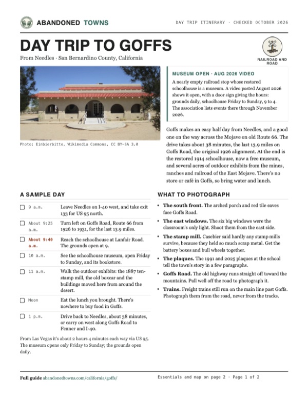
Goffs's first school opened in the fall of 1911 in a rented frame building. In 1914 the district built its own: a one-room Mission Revival schoolhouse designed by the architect Anthony Beimer and built on land donated by H. P. Ware, with arched porches, red tile eaves and a wall of six big east windows that were the classroom's only light. Its district covered about 1,000 square miles, and many pupils came from Mexican immigrant families; bilingual students helped the teacher translate. Dances were held in it, and it housed a branch of the county library. Pupils were each given a cottonwood to water on the schoolyard's southwest side.
The school closed in the spring of 1937, after 412 students, when the district merged with Needles; the association's history says a new school at Essex replaced it. It became a private home in 1938, served the soldiers of Camp Goffs as a canteen in the war, and stood abandoned from 1954 to 1982, by the 1991 plaque at its door. Jim and Bertha Wold bought it in 1982 and started restoring it, and the Friends of the Mojave Road carried the work on from 1990.
Dennis and Jo Ann Casebier had bought the school and 113 acres around it in 1989. They gave the deed to the association on June 20, 1998, and that summer crews reframed the vandalized east wall, replaced the tiles and eaves and restuccoed the walls. By December it was finished, working drinking fountain and all, at a cost of $133,850 raised from private donors. It went on the National Register in 2001. Casebier, who spent his life collecting the history of the Mojave and reopened the old Mojave Road as a four-wheel-drive trail, died in 2021.
What's there
The museum grounds and the town


The museum. The schoolhouse holds displays, a bookstore and gift shop, and the association's archive: about 6,000 books on the Mojave and a large collection of historical photographs and oral histories. The outdoor exhibits spread around it. The association describes a ten-stamp ore mill built in 1887 for a Montana mine, bought by Casebier in 1996 and restored at Goffs by volunteers from October 2010 to September 2013. A Victor Valley Daily Press profile of September 1, 1999, reprinted on the association's site, also describes the tiny Danby courthouse, a building from the Golden Queen Mine near Mojave, an old Atlantic and Pacific boxcar used as a cookhouse, and a 1920s state highway maintenance station that was moved to Essex when Route 66 was realigned and brought back to Goffs as the library in 1992.
The town. Little else stands. The general store, built in 1946 by the county fire department's account, held a bar, restaurant and dance hall, closed around 2001 and burned on June 8, 2021, in a fire investigators called suspicious. Wikipedia describes it as an early 20th-century store; the two accounts differ on its age. A cluster of mailboxes stood by the road in 2011, and the 2025 plaque says a store and café operated "until recently." The railroad still runs past, and Casebier said in 1999 that the rock streets laid by the soldiers of Camp Goffs could still be seen. A plaque placed in 2008 by the Billy Holcomb chapter of E Clampus Vitus and the association marks the Army camp.
Route 66. Goffs Road is the 1926–1931 Route 66, a 40-mile loop off I-40 from US 95 through Goffs to Fenner. Legends of America calls it a stretch of near-nothingness, with the sites of Ibis, Bannock and Homer along it and no open gas, food or lodging. Goffs Road appears in the opening scene of the 1984 film Repo Man.
The 1942 USGS sheet below shows Goffs where a Santa Fe branch leaves the main line for the north, with the highway heading east, 23.5 miles to Needles. The 1956 Fenner sheet marks a cemetery west of the station, the Old Trails road and a landing strip to the northeast. The 1984 Goffs sheet shows the station, a water tank and the roads north.
- Goffs Schoolhouse (1914, restored 1998)
- Ten-stamp mill (1887, restored at Goffs 2010–2013)
- Danby courthouse (moved)
- Highway maintenance station (moved, library)
- Atlantic and Pacific boxcar
- Camp Goffs plaque (2008)
- Site of the general store (burned 2021)
- Goffs Road (Route 66, 1926–1931)


Historic maps
Goffs on USGS maps, 1942–1984
Crops from the USGS Historical Topographic Map Collection, centered on the townsite. Each sheet shows what surveyors mapped that year; compare them with today's topo and aerial on this page.

Day trip
Plan a day trip to Goffs from Needles
Take it with you
Day trip itinerary
The essentials, the sample day with boxes to tick, what to photograph and the coordinates, on two printable pages. Handy where there's no signal.
Download the PDF (421 KB)Goffs makes an easy half day from Needles, and a good one on the way across the Mojave on old Route 66. The drive takes about 38 minutes, the last 13.9 miles on Goffs Road, the original 1926 alignment. At the end is the restored 1914 schoolhouse, now a free museum, and several acres of outdoor exhibits from the mines, ranches and railroad of the East Mojave. There's no store or café in Goffs, so bring water and lunch.
A sample day
- Leave Needles on I-40 west, and take exit 133 for US 95 north.
- Turn left on Goffs Road, Route 66 from 1926 to 1931, for the last 13.9 miles.
- Reach the schoolhouse at Lanfair Road. The grounds open at 9.
- See the schoolhouse museum, open Friday to Sunday, and its bookstore.
- Walk the outdoor exhibits: the 1887 ten-stamp mill, the old boxcar and the buildings moved here from around the desert.
- Eat the lunch you brought. There's nowhere to buy food in Goffs.
- Drive back to Needles, about 38 minutes, or carry on west along Goffs Road to Fenner and I-40.
From Las Vegas it's about 2 hours 4 minutes each way via US 95. The museum opens only Friday to Sunday; the grounds open daily.
What to photograph and film
- The south front. The arched porch and red tile eaves face Goffs Road.
- The east windows. The six big windows were the classroom's only light. Shoot them from the east side.
- The stamp mill. Casebier said hardly any stamp mills survive, because they held so much scrap metal. Get the battery boxes and bull wheels together.
- The plaques. The 1991 and 2025 plaques at the school tell the town's story in a few paragraphs.
- Goffs Road. The old highway runs straight off toward the mountains. Pull well off the road to photograph it.
- Trains. Freight trains still run on the main line past Goffs. Photograph them from the road, never from the tracks.
Map & directions
Getting there
Needles is the nearest city. The route runs west on I-40, north on US 95 at exit 133, and west on Goffs Road, the 1926–1931 Route 66, for the last 13.9 miles. The schoolhouse is on the right at Lanfair Road, just before the townsite point where the route ends. From Las Vegas, US 95 runs south all the way to Goffs Road.

Base map: USGS The National Map (public domain). Routes: OSRM on © OpenStreetMap contributors data (ODbL), computed October 2026. Times assume dry roads.
- From central Needles, follow Needles Highway (Historic Route 66) to I-40.1.3 mi
- Take I-40 west.7.7 mi
- Take exit 133 and follow US 95 north.6.7 mi
- Turn left on Goffs Road (Historic Route 66) and follow it west to Goffs. The schoolhouse is on the right at Lanfair Road.13.9 mi
- From downtown Las Vegas, take Ogden Avenue and Las Vegas Boulevard to I-11.0.6 mi
- Take I-11 (US 93 and US 95) south to the Boulder City Bypass.21.8 mi
- Take exit 14 and follow US 95 south into California.72.1 mi
- Turn right on Goffs Road (Historic Route 66) and follow it to Goffs. The schoolhouse is on the right at Lanfair Road.13.9 mi
Directions go to the Goffs Schoolhouse Museum, 37198 Lanfair Road, where the drive ends, not to the townsite.
Road and safety notes
- Goffs Road is the 1926–1931 Route 66, a loop of about 40 miles off I-40 from US 95 through Goffs to Fenner. Legends of America found no open gas station, restaurant or motel along it.
- The 1931–1972 alignment between Mountain Springs Road and Goffs Road was closed by a damaged bridge in 2015, Route 66 News reported. We found no report of it reopening; use Goffs Road.
- There is no store or café in Goffs. Fuel, food and water are in Needles.
- The BNSF main line runs through Goffs. Stay off the tracks and the railroad land.
- The association warns that cell service is patchy in the East Mojave and recommends carrying a satellite messenger if you head into the backcountry.
Photos
Goffs in photos
Visitor reports
Been to Goffs?
Been there lately? Tell the next visitor what you found: whether you could get in, the state of the road and what's still standing. Photos are welcome. We read every report before it appears here.
Railroad and road
More railroad, road and fort ghost towns
The nearest in California, then the nearest elsewhere.

 Guide
Ludlow
34.72, -116.16San Bernardino County, California
A railroad town that died twice: once when its mines and railroads quit, and again when I-40 replaced Route 66. A few people still run the gas…
 Guide
Fort Mohave
35.04, -114.62Mohave County, Arizona
An Army post built in 1859 to control the Mojave people and guard a river crossing, then a boarding school for Native children until the 1930s. A few…
Nearby
Other sites near Goffs
Straight-line distance from the townsite to other mapped sites in our California index.
- Essex16.5 mi SW · San Bernardino
- Providence25.4 mi W · San Bernardino
- Danby25.4 mi SW · San Bernardino
- Hart25.6 mi N · San Bernardino
- Barnwell27.6 mi N · San Bernardino
- Vanderbilt30.1 mi N · San Bernardino
- Beal31.1 mi E · San Bernardino
- Ivanpah32.3 mi NW · San Bernardino
Sources
Sources and credits
- Wikipedia, "Goffs, California", retrieved October 2026: coordinates (GNIS), the 1883 siding and helper engines, Blake and the Nevada Southern, Route 66 until 1931, the store fire of June 8, 2021, Camp Goffs, Goffs Road, Repo Man, the Desert Tortoise Capital.
- Wikipedia, "Goffs Schoolhouse": the 1914 opening, Anthony Beimer, the 1,000-square-mile district, bilingual pupils, the library branch, the 1937 closing, the wartime canteen, the National Register listing of October 11, 2001.
- Mojave Desert Heritage and Cultural Association, "Contact Us", read October 22, 2026 (official site): hours, appointments, phone, email, free admission, the location at Lanfair and Goffs roads.
- MDHCA, "Schoolhouse Restoration" and "Goffs Schoolhouse": the 1998 restoration diary, the 2001 listing, the cottonwoods, the community uses, the Old Trails Road jog by the White Cottage Restaurant.
- MDHCA, "History", with Stuart Kellogg's Victor Valley Daily Press profile of Dennis Casebier (September 1, 1999): the 1883 siding, the 1907 Searchlight line, the 1911 and 1914 schools, 412 students, the 1989 purchase of 113 acres, the 1993 founding, $133,850, the exhibits, 16,000 troops.
- MDHCA, "Ten-Stamp Mill" and "Calendar", read October 2026: the mill's history and its 2010–2013 restoration; the 2026 events.
- MDHCA, "About" and "Safety Recommendations": Dennis Casebier (1934–2021); cell coverage and satellite messengers.
- Kathy Alexander, "Ghost Town Stretch Across the Mojave", Legends of America, updated August 2026: Goffs Road as the pre-1931 alignment, no services on it, the museum and outdoor exhibits.
- Route 66 News, "Fire destroys long-closed Goffs General Store", June 11, 2021, quoting San Bernardino County Fire: the store built in 1946, closed about 20 years, the suspicious fire.
- Route 66 News, "Will the Mountain Springs Road section of Route 66 reopen?", December 28, 2015: the 1931–1972 alignment and its closure, most travelers using Goffs Road.
- The "Goffs – Gateway to the East Mojave" plaque (E Clampus Vitus and MDHCA, dedicated May 4, 2025), photographed April 23, 2026: Vanderbilt, Isaac Blake from 1892, the second railroad, the Lanfair Valley homesteaders, three garages and two hotels, the 563rd Quartermaster company, the store and café closed.
- The 1991 Goffs Schoolhouse plaque, photographed 2018, and the 2008 Army camp plaque, photographed 2010: the 1911 school, Beimer and H. P. Ware, the 1938–1982 years, the Wolds; the camp's 1942–1944 dates and the 7th Infantry Division.
- Wayfairing Wirth's, "Wayfaring Wirths", YouTube, posted August 26, 2026: the grounds and the open schoolhouse, the door sign with the hours (the video on this page).
- USGS historical topographic maps: Amboy 1:250,000 (1942), Fenner 1:62,500 (1956), Goffs 1:24,000 (1984). Elevation: USGS 3D Elevation Program point query. Routes: OSRM on OpenStreetMap data, October 2026. Not field-checked.
Photo and map credits
- The schoolhouse's south front, June 2016: Einbierbitte, Wikimedia Commons, CC BY-SA 3.0
- The "Goffs School 1914, 37198 Lanfair" sign, September 2018: Beckettphotographer1, Wikimedia Commons, CC BY-SA 4.0
- The schoolhouse from the southwest, September 2018: Beckettphotographer1, Wikimedia Commons, CC BY-SA 4.0
- The 2025 "Goffs – Gateway to the East Mojave" plaque, April 2026: Rue7wiki, Wikimedia Commons, CC BY-SA 4.0
- The west side, behind the gate, June 2016: Einbierbitte, Wikimedia Commons, CC BY-SA 3.0
- The north side, June 2016: Einbierbitte, Wikimedia Commons, CC BY-SA 3.0
- The six east windows, June 2016: Einbierbitte, Wikimedia Commons, CC BY-SA 3.0
- A soldier at the Goffs station, 1943: US Army, Wikimedia Commons, Public domain
- The Army camp plaque, March 2010: Netherzone, Wikimedia Commons, CC BY-SA 4.0
- The 1991 schoolhouse plaque, September 2018: Beckettphotographer1, Wikimedia Commons, CC BY-SA 4.0
- Mailboxes beside the road, January 2011: Finea, Wikimedia Commons, CC BY 3.0
- Camp Goffs beside the Santa Fe tracks, 1943: US Army, Wikimedia Commons, Public domain
- Topo map, area base map and aerial imagery: USGS The National Map (public domain). Historic sheets: USGS Historical Topographic Map Collection (public domain).
- Historic maps: USGS Historical Topographic Map Collection (public domain): Amboy 1942, 1:250,000; Fenner 1956, 1:62,500; Goffs 1984, 1:24,000.