 Abandoned

Overview
The camp that stayed standing

Prospectors were working the upper Chalk Creek valley by 1878, and in 1880 a town was laid out there as Forest City. There were too many Forest Citys already, so one of the founders, Griffith Evans, renamed it Saint Elmo after a novel he was reading. About 150 patented mine claims surrounded it. The biggest producer was the Mary Murphy, high on the mountain above the railroad.
The Denver, South Park and Pacific arrived in 1881 and carried on to the Alpine Tunnel. Saint Elmo grew to five hotels, saloons, dance halls, a school, a town hall and a weekly paper, with a population put at nearly or more than 2,000. A fire in 1890 burned the business district, and the town never fully rebuilt. The tunnel closed in 1910 and the trains stopped in 1922. By 1930 seven people were left.
The Stark family stayed on, running the store and the Home Comfort Hotel, and the post office lasted until 1952. The main street went on the National Register in 1979. Today the buildings are privately owned, a few people live here year-round, and the general store opens each summer.
Timeline
Boom, fire and the last train


- Prospectors settle in the upper Chalk Creek valley. Legends of America dates the first settlement to 1878; an undated listing gives 1878 or 1879.
- The town is laid out as Forest City. Too many towns already share the name, so founder Griffith Evans renames it Saint Elmo, after a novel.
- The weekly St. Elmo Mountaineer starts reporting on the mines. It runs until 1895.
- The Denver, South Park and Pacific Railroad reaches town and builds a station. The line runs on toward Romley, Hancock and the Alpine Tunnel.
- Cattleman Anton Stark settles here. His wife Anna later runs a general store and the Home Comfort Hotel.
- Fire destroys the business district at about the town's peak. It is never fully rebuilt.
- The Alpine Tunnel closes, and the long decline begins.
- Rail service ends. The tracks come up in 1926 and the grade becomes the road from Nathrop.
- The Mary Murphy, the district's biggest mine, shuts down. Wikipedia says it ran until 1922; Legends of America says 1925.
- Seven people are left, by Legends of America's count.
- The post office closes after the postmaster's death.
- Annabelle Stark is moved to a nursing home in 1958 and dies in 1960.
- The Saint Elmo Historic District, about 70 acres, is listed on the National Register of Historic Places.
- Fire destroys six buildings, including the town hall and jail. Owners donate the town hall lot and the schoolhouse to Buena Vista Heritage that July.
- The town hall is rebuilt as a replica. Wikipedia dates it to 2008; the county visitors bureau says 2009.
What's left
What you'll see


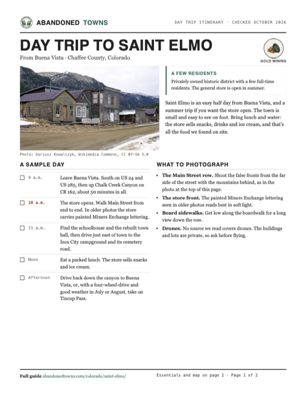
Main Street is the reason to come. Weathered two-story stores and smaller houses stand in a row along the dirt street, with board sidewalks in front. Buena Vista Heritage owns the schoolhouse, in use from 1882 into the 1940s, and the town hall, rebuilt as a replica after the 2002 fire. Everything else is private. In a photo on this page from about 2000–2002, the general store is in a building painted with the words Miners Exchange, and a sign beside it reads "All St. Elmo property is privately owned" and asks visitors to stay on the streets.
East of town, the Iron City campground sits on the site of a short-lived smelter town, and a road leads from it to the Iron City cemetery. Chalk Creek runs through Saint Elmo, but the creek in town is private. Wikipedia notes public fishing access at a few spots by the campground.
The 1940 USGS sheet in the historic maps below shows St. Elmo where the creek bends, with Iron City just to the northeast and roads climbing the side gulches. The 1960 sheet zooms out to show Tincup on the far side of the Continental Divide, Romley and Hancock up the canyon, and the Mount Princeton Hot Springs lodge down it.
- Main Street stores and houses
- General store (summer)
- Schoolhouse
- Town hall (replica)
- Iron City cemetery, east of town


Historic maps
Saint Elmo on USGS maps, 1940–1960
Crops from the USGS Historical Topographic Map Collection, centered on the townsite. Each sheet shows what surveyors mapped that year; compare them with today's topo and aerial on this page.
Day trip
Plan a day trip to Saint Elmo from Buena Vista
Take it with you
Day trip itinerary
The essentials, the sample day with boxes to tick, what to photograph and the coordinates, on two printable pages. Handy where there's no signal.
Download the PDF (510 KB)Saint Elmo is an easy half day from Buena Vista, and a summer trip if you want the store open. The town is small and easy to see on foot. Bring lunch and water: the store sells snacks, drinks and ice cream, and that's all the food we found on site.
A sample day
- Leave Buena Vista. South on US 24 and US 285, then up Chalk Creek Canyon on CR 162, about 50 minutes in all.
- The store opens. Walk Main Street from end to end. In older photos the store carries painted Miners Exchange lettering.
- Find the schoolhouse and the rebuilt town hall, then drive just east of town to the Iron City campground and its cemetery road.
- Eat a packed lunch. The store sells snacks and ice cream.
- Drive back down the canyon to Buena Vista, or, with a four-wheel-drive and good weather in July or August, take on Tincup Pass.
What to photograph and film
- The Main Street row. Shoot the false fronts from the far side of the street with the mountains behind, as in the photo at the top of this page.
- The store front. The painted Miners Exchange lettering seen in older photos reads best in soft light.
- Board sidewalks. Get low along the boardwalk for a long view down the row.
- Drones. No source we read covers drones. The buildings and lots are private, so ask before flying.
Map & directions
Getting there
Buena Vista is the nearest town. The route runs south on US 24 and US 285, cuts across on county roads 280 and 270, and climbs Chalk Creek Canyon on County Road 162 to the end of the road at Saint Elmo. From Denver it's US 285 all the way to the same turn.


Base map: USGS The National Map (public domain). Routes: OSRM on © OpenStreetMap contributors data (ODbL), computed October 2026. Times assume dry roads.
- From downtown Buena Vista, follow East Main Street and turn left onto US 24 south.2.5 mi
- Continue south as the highway becomes US 285.6.7 mi
- Turn right on CR 280, then right again at its end on CR 270.4.1 mi
- Turn left on CR 162 and follow it up Chalk Creek Canyon to St. Elmo.12.0 mi
- From downtown Denver, follow Kalamath Street and Santa Fe Drive (US 85) south to US 285.6.7 mi
- Follow US 285 (Hampden Avenue at first) southwest.110.8 mi
- At the junction with US 24, turn left to stay on US 285 south.6.7 mi
- Turn right on CR 280, right on CR 270, then left on CR 162 up the canyon to St. Elmo.16.0 mi
Road and safety notes
- The state tourism office says "you can get to St. Elmo in a regular car or by ATV" (updated September 2026).
- Winter access is not verified. The newest report we found is from December 2023, when Ark Valley Voice wrote that the county "now plows CR 162 all the way to St. Elmo consistently after each snow," usually within 24 hours of a storm ending. Check with Chaffee County Road and Bridge before a winter trip.
- Past town, Tincup Pass (CR 267) is a four-wheel-drive road over the Divide to Tincup, rated moderate by 4x4explore. Its 2021 guide calls July and August the best months and says snow can close it from October.
- Saint Elmo sits near 10,000 feet. Walk slowly and drink water.
Photos
Saint Elmo in photos
Visitor reports
Been to Saint Elmo?
Been there lately? Tell the next visitor what you found: whether you could get in, the state of the road and what's still standing. Photos are welcome. We read every report before it appears here.
Gold mining
More gold mining ghost towns
The nearest in Colorado.

 Guide
Tin Cup
38.75, -106.48Gunnison County, Colorado
A mining camp of 1879 named for a tin cup of gold, known early on for killing its marshals. It never fully emptied: the old town is now mostly summer…
 Guide
Independence
39.11, -106.61Pitkin County, Colorado
Independence’s brief gold rush left log cabins and mill remains beside Colorado 82. The historical society maintains a self-guided trail through the…
Nearby
Other sites near Saint Elmo
Straight-line distance from the townsite to other mapped sites in our Colorado index.
- Tin Cup8.0 mi NW · Gunnison
- Abbeyville9.4 mi NW · Gunnison
- Monarch10.9 mi S · Chaffee
- Garfield11.2 mi S · Chaffee
- Pitkin11.3 mi SW · Gunnison
- White Pine11.6 mi S · Gunnison
- Maysville13.5 mi SE · Chaffee
- Buena Vista14.8 mi NE · Chaffee
Sources
Sources and credits
- ghosttowns.com, "Saint Elmo": fact sheet fields (roads, climate, best time, founding dates).
- Wikipedia, "Saint Elmo, Colorado", retrieved October 2026: Forest City and the renaming, the mines and claims, the Mountaineer, the railroad, the 1952 post office closing, the 2002 fire and rebuilt town hall, the National Register listing, creek access, coordinates and elevation.
- Legends of America, "St. Elmo", updated October 2026: 1878 settlement, the 1881 railroad, the 1890 fire, the Alpine Tunnel, the Mary Murphy, the 1930 population, the Stark family, the April 2002 fire and donation.
- St. Elmo General Store, the store's own site (2026): season, hours, address, phone and what it sells.
- Chaffee County Visitors Bureau, "Museums and Historical Tours", October 2026: three full-time residents, the schoolhouse dates, the 2009 town hall replica, Iron City.
- Colorado Tourism Office, "Colorado Ghost Towns", updated September 16, 2026: car access.
- Ark Valley Voice, December 8, 2023: winter plowing of CR 162, the newest report we found.
- 4x4explore, "Tincup Pass", driven July 2021: the pass road, its rating and season.
- Elevation: USGS 3D Elevation Program point query. Routes: OSRM on OpenStreetMap data, October 2026.
Photo and map credits
- Main Street with snow on the peaks, about 2000–2002: Dariusz Kowalczyk, Wikimedia Commons, CC BY-SA 3.0
- The store and post office row, July 2008: John S. Hirth, Wikimedia Commons, CC BY-SA 3.0
- The general store, lettered Miners Exchange, about 2000–2002: Dariusz Kowalczyk, Wikimedia Commons, CC BY-SA 3.0
- The Stark Bros. store and post office front, June 2005: Rolf Blauert, Wikimedia Commons, Public domain
- Panorama of the historic district, September 2014: Lookinhere, Wikimedia Commons, CC BY-SA 3.0
- The schoolhouse, 2012: Ronzeidler, Wikimedia Commons, CC BY-SA 3.0
- A two-story log house, 2005: Rolf Blauert, Wikimedia Commons, Public domain
- The original town hall and jail, before the 2002 fire: Dariusz Kowalczyk, Wikimedia Commons, CC BY-SA 3.0
- The Russell Thorp Building, named on its plaque, July 2008: John S. Hirth, Wikimedia Commons, CC BY-SA 3.0
- Main Street storefronts, June 2005: Rolf Blauert, Wikimedia Commons, Public domain
- A dirt street between old buildings, looking toward the mountains, June 2005: Rolf Blauert, Wikimedia Commons, Public domain
- St. Elmo and Iron City on the 1940 USGS Garfield sheet: U.S. Geological Survey, USGS catalog, Public domain
- Topo map, area base map and aerial imagery: USGS The National Map (public domain).
- Historic maps: USGS Historical Topographic Map Collection (public domain): Garfield 1940, 1:62,500; Montrose 1960, 1:250,000.