 Abandoned

Overview
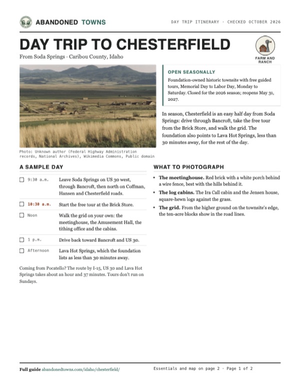
A grid of ten-acre blocks in Gem Valley

Chesterfield sits at about 5,450 feet in Gem Valley, on the bench above the Portneuf River north of Bancroft. Chester Call and Christian Nelson ran horses here from 1879, family and friends followed, and by 1881 and 1882 settlers were living in the river bottom. In 1883 church leaders asked them to move up to higher ground, and the town was laid out the way Mormon towns were: a grid of 35 ten-acre blocks. The Chesterfield Ward was organized in 1884 with 136 people. Over the next decades they built a brick meetinghouse, an amusement hall, a tithing office and granary, stores and a school.
Chesterfield never had an easy run. Hard winters and drought, then the Panic of 1907, sent families away; by 1908 fewer than 400 were left in the area. It recovered to just under 700 by about 1920, then lost people again in the farm troubles of the 1920s. The railroad went through Bancroft instead, and by the end of the 1930s the town was deserted. The school closed in 1941 and the general store in 1958. In 1970 Wikipedia counts 20 people in historic Chesterfield.
Since 1980 the Chesterfield Foundation, run by volunteers and donations, has bought the 120-acre townsite and restored its buildings one by one. The district went onto the National Register in December 1980. Each summer, from Memorial Day to Labor Day, guides lead free tours from the Brick Store.
Timeline
Horse ranch, ward, ghost town, museum

- Chester Call and his niece's husband, Christian Nelson, start a horse ranch in the valley, by Wikipedia's account. The Chesterfield Foundation says Call came through in 1880 looking for grazing land and brought his family the next spring.
- Settlers arrive and build in the Portneuf River bottom. The town takes its name from Chester Call.
- Church leaders ask the settlers to move to higher ground, and the townsite is laid out as a Mormon grid of 35 ten-acre blocks. The Chesterfield Ward is organized in 1884 with 136 people in 24 families.
- The brick meetinghouse goes up.
- The Amusement Hall is built next door to the meetinghouse.
- The Tithing Office and Tithing Granary are built.
- Hard winters and drought, then the Panic of 1907, drive families away. By 1908 fewer than 400 people are left in the area.
- The Chesterfield area peaks at just under 700 people.
- Recessions and farm troubles thin the town again; just over 425 people are left in the area by 1928. The railroad has gone through Bancroft instead, and by the end of the 1930s, Wikipedia says, Chesterfield is deserted.
- The school closes.
- The general store closes.
- Fewer than 200 people live in the area, and 20 in historic Chesterfield.
- The Chesterfield Foundation takes charge of the townsite and restores the meetinghouse first. On December 4 the Chesterfield Historic District joins the National Register of Historic Places.
- Idaho Heritage Trust grants go to the foundation, which has bought the 120-acre townsite. The Amusement Hall is restored in 1999–2003 and the Nathan Barlow House in 2009, by Wikipedia's account.
- With Labor Day past, the foundation's site announces the next opening: "Site OPEN ON Memorial Day 2027."
What's left
Brick, logs and a meetinghouse


The National Register district counts 41 buildings and eight sites spread over 2,160 acres; Visit Idaho's byway page counts 27 original structures in the town. The foundation's building list names the meetinghouse, the Amusement Hall, the Brick Store (Holbrook Mercantile), where tours begin, the Tithing Office and Granary, the Log Store, the Muir Store, a livery stable, a blacksmith shop, schoolhouses, and the houses and cabins of the Call, Loveland, Muir, Butterfield, Barlow, Holbrook, Jensen and Simons families. Its home page says the Robertson Cabin is opening to visitors but gives no year. The foundation doesn't say which interiors are open on a given day.
The 1917 USGS sheet in the historic maps below shows Chesterfield as a small street grid with a benchmark at 5,454 feet. The 1962 sheet sets it in the Portneuf Valley below the Chesterfield Range, with Chesterfield Reservoir to the northwest, and the 1981 sheet labels the Meeting House (Historical Site) on the west side of the grid.
- Meetinghouse (1887–1892)
- Amusement Hall (1895, restored 1999–2003)
- Tithing Office and Granary (1900)
- Brick Store (Holbrook Mercantile)
- Log Store
- Nathan Barlow House (restored 2009)
- Ira Call cabin
- Denmark Jensen house
- Livery stable and blacksmith shop
- Schoolhouses


Historic maps
Chesterfield on USGS maps, 1917–1981
Crops from the USGS Historical Topographic Map Collection, centered on the townsite. Each sheet shows what surveyors mapped that year; compare them with today's topo and aerial on this page.
Day trip
Plan a day trip to Chesterfield from Soda Springs
Take it with you
Day trip itinerary
The essentials, the sample day with boxes to tick, what to photograph and the coordinates, on two printable pages. Handy where there's no signal.
Download the PDF (465 KB)In season, Chesterfield is an easy half day from Soda Springs: drive through Bancroft, take the free tour from the Brick Store, and walk the grid. The foundation also points to Lava Hot Springs, less than 30 minutes away, for the rest of the day.
A sample day
- Leave Soda Springs on US 30 west, through Bancroft, then north on Coffman, Hansen and Chesterfield roads.
- Start the free tour at the Brick Store.
- Walk the grid on your own: the meetinghouse, the Amusement Hall, the tithing office and the cabins.
- Drive back toward Bancroft and US 30.
- Lava Hot Springs, which the foundation lists as less than 30 minutes away.
Coming from Pocatello? The route by I-15, US 30 and Lava Hot Springs takes about an hour and 37 minutes. Tours don't run on Sundays.
What to photograph and film
- The meetinghouse. Red brick with a white porch behind a wire fence, best with the hills behind it.
- The log cabins. The Ira Call cabin and the Jensen house, square-hewn logs against the grass.
- The grid. From the higher ground on the townsite's edge, the ten-acre blocks show in the road lines.
Map & directions
Getting there
Soda Springs is the nearest city, about an hour away by US 30 through Bancroft and county roads north. From Pocatello the route runs down I-15 to McCammon, east on US 30 to just past Lava Hot Springs, then north. East Idaho News described the same turn in 2015: north at the Chesterfield sign just east of Lava Hot Springs. The foundation's address is 3123 Chesterfield Road.

Base map: USGS The National Map (public domain). Routes: OSRM on © OpenStreetMap contributors data (ODbL), computed October 2026. Times assume dry roads.
- Head west on 2nd South Street (US 30 / ID 34) out of Soda Springs, then bear right.6.8 mi
- Continue west on Old Highway 30.8.4 mi
- Follow 1st Street through Bancroft and Old Highway 30 beyond it.3.1 mi
- Turn right on Coffman Road and head north.5.6 mi
- Turn right on Stalker Road, then left on Hansen Road.2.9 mi
- Turn right on Chesterfield Road into the townsite.0.8 mi
- From North 7th Avenue, take Wyeth Street and 4th and 5th avenues (I-15 Business / US 30) south.2.9 mi
- Join I-15 south (with US 30 and US 91).19.5 mi
- Exit at McCammon and follow East Merrill Road (US 30) east.13.2 mi
- Turn left on Blaser Road just east of Lava Hot Springs; it becomes Old Highway 30.14.1 mi
- Turn onto Ten Mile Pass Road, then left on Coffman Road.5.8 mi
- Turn right on Stalker Road, then left on Hansen Road.2.9 mi
- Turn right on Chesterfield Road into the townsite.0.8 mi
Road and safety notes
- The routes are computed from OpenStreetMap and haven't been driven by us. We have no dated source on the surface of the county roads to the townsite.
- East Idaho News (2015) puts Chesterfield about 11 miles north of Bancroft. The foundation says Lava Hot Springs and Soda Springs are less than 30 minutes away; our computed route from downtown Soda Springs takes about an hour.
- The tours run Monday to Saturday in summer only. Outside the season the buildings are closed, and the foundation gives no guidance on visiting then. East Idaho News said in 2015 that self-guided outdoor walks were possible off season; we found nothing newer.
Photos
Chesterfield in photos
Visitor reports
Been to Chesterfield?
Been there lately? Tell the next visitor what you found: whether you could get in, the state of the road and what's still standing. Photos are welcome. We read every report before it appears here.
Farm and ranch
More farm and ranch ghost towns
The nearest, in other states.

 Guide
Iosepa
40.54, -112.73Tooele County, Utah
Families from Hawaiʻi and other Pacific islands built Iosepa in 1889. Its cemetery remains a place of remembrance for their descendants.
 Guide
Fruita
38.29, -111.24Wayne County, Utah
A small farming community grew where Sulphur Creek meets the Fremont River. Capitol Reef preserves its orchards, schoolhouse and Gifford farm…
Nearby
Other sites near Chesterfield
Straight-line distance from the townsite to other mapped sites in our Idaho index.
Sources
Sources and credits
- ghosttowns.com, "Chesterfield": fact sheet fields (county, road, climate, best time, remains).
- Wikipedia, "Chesterfield, Idaho", retrieved October 2026: the 1879 ranch, the 1881–1882 settlers, the move and the 35 ten-acre blocks, the 1884 ward, the buildings and their dates, the population figures, the school and store closings, the National Register listing and district size, Gem Valley, coordinates and elevation.
- Historic Chesterfield, the Chesterfield Foundation's official site, with its "Visit", "Contact", "About", "Buildings" and "Schedule" pages, read October 20, 2026: the "Site OPEN ON Memorial Day 2027" banner, season, days, hours, free tours, last tour, address, phones, payment, the 1880 founding and the foundation's work since 1980, the building list, the Robertson Cabin, and the 2026 Memorial Day program.
- Idaho Heritage Trust, "Purchase & Renovation of Chesterfield Ghost Town": the foundation's purchase of the 120-acre townsite and the grants of 1992–2010.
- Visit Idaho, "Pioneer Historic Byway": 27 original structures.
- Joe Law, "The ghost town of Chesterfield," East Idaho News, October 30, 2015: the turn north just east of Lava Hot Springs, the distance from Bancroft and the self-guided outdoor walks possible off season in 2015.
- Kenneth Mays, "Picturing history: Chesterfield, Caribou County, Idaho," Deseret News, December 2, 2015: the town named for Chester Call.
- Photos: Wikimedia Commons, credited below each one. The meetinghouse, Call cabin and Jensen house photos come from the Chesterfield Foundation under a permission ticket recorded on Commons; their dates aren't recorded, only that they were uploaded in February 2010. The townsite view is a Federal Highway Administration byway photo (1995–2013) held by the National Archives. Elevation: USGS 3D Elevation Program point query. Routes: OSRM on OpenStreetMap data, October 2026. Not field-checked.
Photo and map credits
- The townsite and the valley, from the Pioneer Historic Byway photo record: Unknown author (Federal Highway Administration records, National Archives), Wikimedia Commons, Public domain
- The brick meetinghouse, built 1887–1892: Val Roberts and Chesterfield Foundation, Inc, Wikimedia Commons, CC BY-SA 3.0
- The Ira Call cabin: Val Roberts and Chesterfield Foundation, Inc, Wikimedia Commons, CC BY-SA 3.0
- The Denmark Jensen house: Val Roberts and Chesterfield Foundation, Inc, Wikimedia Commons, CC BY-SA 3.0
- Chesterfield's street grid on the 1917 USGS sheet: U.S. Geological Survey, USGS catalog, Public domain
- Area base map, topo and aerial imagery: USGS The National Map (public domain).
- Historic maps: USGS Historical Topographic Map Collection (public domain): Portneuf 1917, 1:62,500; Preston 1962, 1:250,000; Chesterfield 1981, 1:24,000.