 Abandoned
Overview
The town the lake never reached

Elkinsville grew up in the 1850s on the flats of Salt Creek in southern Brown County and took the name of William Elkins, an early settler. It was a farm village. A post office opened in 1860, and by the late 1800s, as the memorial to the town puts it, there was a one-room school, a grocery, a church and "a simple way of life." The post office closed in 1941, but the village was still on the 1950 USGS map, with about a dozen buildings at a crossroads under Browning Hill.
In 1960 work began on the Monroe Reservoir downstream, for flood control and a water supply for Bloomington. The Army Corps of Engineers took the whole town by eminent domain between 1962 and 1964. "They moved the families, they displaced them and they razed everything," a Monroe County History Center librarian told Indiana Public Media in 2023.
Then, by Wikipedia's account, someone found an error in the elevation estimates: the lake would never have flooded Elkinsville. By then the town was gone. Its former residents were still meeting for a reunion every October in 2008, and their cemetery stands above the flood plain north of the townsite.
Video
A spring drive from Story into the valley
A dashboard-camera drive on a sunny spring day. It starts in Story, past its old buildings, then follows narrow paved and gravel roads through woods and open pasture. Around the ten-minute mark an on-screen title marks Elkinsville, and the car rolls along a gravel road past meadows, a few fenced fields, a small red-roofed outbuilding and long stretches of forest. The video has music and no narration. The car stays on the public roads.
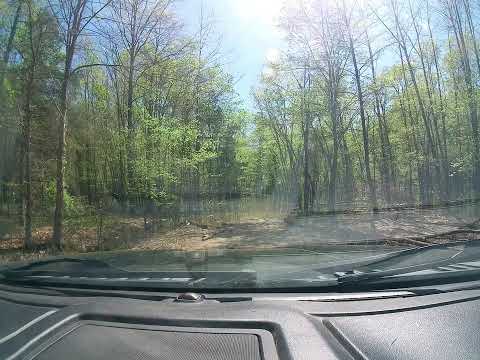 Play “Story and Elkinsville, IN” from YouTube
Timeline
From farm village to flood plain
- The village grows up in the Salt Creek valley and is named for William Elkins, a pioneer settler.
- A post office opens at Elkinsville.
- By the memorial's account the town has a one-room school, a grocery, a post office and a church.
- The post office closes.
- The USGS Elkinsville sheet shows the village strung along the road on the east side of Salt Creek, with about a dozen buildings around the crossroads.
- Work begins on the Monroe Reservoir, built for flood control downstream and to supply water to Bloomington.
- The Army Corps of Engineers buys out the town by eminent domain. Families move away and the buildings are razed.
- The revised USGS sheet shows the townsite all but empty, with marsh on the flats along Salt Creek.
- It turns out a mistake in the elevation estimates meant the town would not have been flooded after all.
- Former residents start an annual Elkinsville reunion. By 2008 it met on the first Sunday in October.
- Volunteers build a shelter with a history board at Elkinsville Cemetery.
- A visitor photographs the "Town That Was" memorial stone.
What's left
A memorial, a cemetery and the valley

Nothing of the village stands as it was. Wikipedia lists some private homes and the Elkinsville Cemetery as what remains. A landowner who bought land there just after the buyout told the local magazine Our Brown County in 2008 that he was restoring the old post office building at the south edge of the town, and that the reunion met on his property at the foot of Browning Mountain. That is private land.
The cemetery dates to about 1830 and sits above the flood plain, about a mile north of the crossroads by its listed coordinates. Find a Grave counts 334 memorials. Volunteers with ties to the town built a shelter there in 1992, with a bulletin board of history. To reach it, turn onto Elkinsville Cemetery Road at the old townsite and go about a mile.
A memorial stone titled "Elkinsville, The Town That Was" carries a verse from the families who left and the town's history. A visitor photographed it in September 2024. Above the valley rises Browning Hill, which locals call Browning Mountain. Wikipedia says it overlooks the old town and is topped by a field of limestone boulders, nicknamed "Indiana's Stonehenge," in a Forest Service special management area.
The 1966 USGS sheet shows the townsite cleared, and the flats along Salt Creek marked as marsh. The 1993 sheet shows the same open ground and Elkinsville Road running east toward Story.
- Elkinsville Cemetery (about 1830), with a 1992 shelter and history board
- Memorial stone, "The Town That Was"
- Old roads and open flats of the townsite
- A few private homes, including the old post office building (private)


Historic maps
Elkinsville on USGS maps, 1942–1993
Crops from the USGS Historical Topographic Map Collection, centered on the townsite. Each sheet shows what surveyors mapped that year; compare them with today's topo and aerial on this page.

Map & directions
Getting there
Nashville is the closest town, 17.5 miles and about 35 minutes away by SR 46 and SR 135 to Story, then west on Elkinsville Road. From Indianapolis the drive runs down I-65 to Columbus and west on SR 46. Both end at the old townsite.


Base map: USGS The National Map (public domain). Routes: OSRM on © OpenStreetMap contributors data (ODbL), computed October 2026. Times assume dry roads.
- From downtown Nashville, take Main Street.0.2 mi
- Turn right on South Van Buren Street (SR 135).0.3 mi
- Turn left on SR 46/SR 135.3.1 mi
- Turn right on SR 135 and follow it south, turning right again where it bends, to Story.9.3 mi
- Keep straight on Elkinsville Road.4.2 mi
- Turn sharp right to the townsite.0.3 mi
- From Monument Circle, take Market Street, Park Avenue and Washington Street to the interstate.1.4 mi
- Join I-65/I-70, then keep left on I-65 south.42.3 mi
- Take exit 68 and merge onto Jonathan Moore Pike (SR 46) west.13.1 mi
- Turn left on SR 135, and right again where it bends, to Story.9.3 mi
- Keep straight on Elkinsville Road.4.2 mi
- Turn sharp right to the townsite.0.3 mi
Road and safety notes
- The routes are computed from OpenStreetMap and haven't been driven by us.
- Find a Grave's directions: turn onto Elkinsville Road from SR 135 at Story, drive about four miles to the old townsite, then turn onto Elkinsville Cemetery Road for about a mile to the cemetery.
- The Forest Service's Nebo Ridge Trail has its north trailhead and a parking lot on Elkinsville Road, about 3 miles from Story, bearing left at the fork (Hoosier National Forest handout, March 2024).
- The Forest Service warns that private and public land is scattered within the forest boundary. Stay on national forest land and respect private property, including the homes and reunion grounds at the townsite.
- In a dashcam video posted April 2025, the roads from Story into the Elkinsville valley are narrow, partly paved and partly gravel.
- Use caution in hunting seasons; the Forest Service recommends blaze orange.
Photos
Have photos of Elkinsville?
We haven’t added more photographs of Elkinsville yet. If you’ve visited, share your photos and a field report below.
Visitor reports
Been to Elkinsville?
Been there lately? Tell the next visitor what you found: whether you could get in, the state of the road and what's still standing. Photos are welcome. We read every report before it appears here.
Farm and ranch
More farm and ranch ghost towns
The nearest in Indiana.

 Guide
Lick Creek
38.49, -86.41Orange County, Indiana
Free Black families from North Carolina farmed these hills from 1831, and their settlement held more than 1,500 acres by 1855. The last landowner…
 Guide
Monument City
40.78, -85.60Huntington County, Indiana
A crossroads village named for the Civil War monument beside it. It was cleared in 1964 for the Salamonie Reservoir, and its foundations and old…
Nearby
Other sites near Elkinsville
Straight-line distance from the townsite to other mapped sites in our Indiana index.
- Weddleville16.6 mi S · Jackson
- Palestine21.5 mi SW · Lawrence
- Kansas21.6 mi NE · Bartholomew
- Wallace Junction36.4 mi NW · Owen
- Lick Creek41.1 mi S · Orange
- Hindostan Falls44.4 mi SW · Martin
- Saint Magdalen47.6 mi E · Ripley
- Ellsworth51.0 mi SW · Dubois
Sources
Sources and credits
- Wikipedia, "Elkinsville, Indiana", retrieved October 2026: the 1850s founding and William Elkins, the post office dates, the 1964 eminent-domain buyout, the elevation mistake, what remains, the national forest, the coordinates.
- Clayton Baumgarth, "Are there people buried under Lake Monroe?," WFIU/WTIU Indiana Public Media, June 6, 2023: construction from 1960, the reservoir's purposes, the whole town taken by eminent domain, and the librarian's quote that everything was razed.
- Find a Grave, "Elkinsville Cemetery", read October 2026: the cemetery's date, 334 memorials, the 1992 shelter and bulletin board, the directions and coordinates, the 1964 acquisition.
- Bill Weaver, "No Place Like Brown County," Our Brown County, September–October 2008: a landowner's purchase after the buyout, the old post office building and its restoration, the reunion since 1987, by then on the first Sunday in October, the adjoining public land.
- Wikipedia, "Browning Hill", retrieved October 2026: the local name, the boulder field and its nickname, the view over Elkinsville, the Forest Service special management area.
- Hoosier National Forest, "Nebo Ridge Trail" handout, March 2024: the trailhead on Elkinsville Road, scattered private and public land, hunting-season caution.
- Quentin Melson, "Elkinsville, Indiana," Wikimedia Commons, photo of September 9, 2024: the memorial stone and its text, including the 1962–1964 Corps purchase and the town's late-1800s school, grocery, post office and church.
- Brandon B, "Story and Elkinsville, IN," YouTube, posted April 27, 2025: the video on this page; a dashcam drive from Story to the townsite showing gravel roads, meadow and woods.
- Historic maps: USGS Historical Topographic Map Collection, Franklin 1942 and Elkinsville 1950, 1966 and 1993 sheets. Elevation: USGS 3D Elevation Program point query. Routes: OSRM on OpenStreetMap data, October 2026. Not field-checked.
Photo and map credits
- Top photo: Quentin Melson, Wikimedia Commons, CC BY-SA 4.0
- Elkinsville on the 1950 USGS sheet: buildings along the road east of Salt Creek, with Spanker Branch to the south: U.S. Geological Survey, USGS catalog, Public domain
- Area base map, topo and aerial imagery: USGS The National Map (public domain).
- Historic maps: USGS Historical Topographic Map Collection (public domain): Franklin 1942, 1:125,000; Elkinsville 1950, 1:24,000; Elkinsville 1966, 1:24,000; Elkinsville 1993, 1:24,000.