 Abandoned

Overview
The village on the battlefield

On January 8, 1815, Andrew Jackson's army beat the British on the Chalmet plantation, just below New Orleans. Half a century later the land belonged to Jean Pierre Fazende, a free man of color and New Orleans grocer. After the Civil War he cut it into 33 lots along a single road from the highway to the river levee and sold them to formerly enslaved people from the plantations around it. The Park Service dates the community to 1867; 64 Parishes and the AP say about 1870.
Its residents called it the Village. It had the Battle Ground Baptist Church (the Park Service's Fazendeville page counts two churches), grocery stores, a one-room school, two benevolent societies, three bars by one account, a baseball diamond in the pasture behind the houses and a pecan grove. The houses stood on one side of the road, many of them shotguns. The Park Service puts the population at more than 200; 64 Parishes counts about 30 families.
The village sat between the Chalmette Monument and the national cemetery, in the middle of the battlefield. A national park there was proposed from the 1930s, and for the 150th anniversary of the battle the government decided to clear the field. Congress authorized the purchase in 1962. Owners who refused to sell lost their land through eminent domain; 64 Parishes reports they got about $6,000 a home when a new one cost about $16,000, while Wikipedia, quoting the same author, gives $4,000 and $19,000. Fazendeville Road closed in November 1964 and the houses came down. The Park Service itself now writes that "the choice to preserve one history sacrificed another."
Timeline
From freedmen's lots to a battlefield park
- The land passes to Jean Pierre Fazende, a free man of color and New Orleans grocer, from his father of the same name. Wikipedia dates the father's succession to 1854; one Park Service page says the son inherited it in 1857, another that it was his by 1870.
- After the Civil War, Fazende divides the land into 33 lots and sells them to formerly enslaved people. The Park Service's Places page dates the community to 1867; 64 Parishes and the AP say about 1870.
- The Battle Ground Baptist Church is founded.
- Residents form the Progressive Mutual Aid and Benevolent Association in 1881. The 1888 state census counts 17 families (Wikipedia, citing historian Ron Chapman).
- The Frisco railroad tries to buy out the village. Many residents refuse.
- A fire destroys the church and eight houses and leaves about sixty people homeless. The cornerstone of a new church is laid in October 1928.
- Options on Fazendeville properties are taken for a national park on the battlefield. Congress creates Chalmette National Historical Park in 1939 (64 Parishes); a 1939 bill to buy Fazendeville is vetoed (Wikipedia).
- The parish closes the village school and buses its pupils to a consolidated school at Violet.
- President Kennedy signs the law creating a sesquicentennial commission and authorizing the purchase of the land along Fazendeville Road.
- Fazendeville Road is closed. More than 50 families are moved out; many resettle in the Lower Ninth Ward, where they build a new Battleground Baptist Church. Demolition is complete by 1966 (Wikipedia). The Park Service dates the decision to tear the village down to 1963, and one family in 64 Parishes' account was forced out that year.
- The 150th anniversary of the Battle of New Orleans is marked on a field restored to an approximate 1815 appearance.
- Anthropologist Joyce Marie Jackson completes a Park Service study of the village, built on oral histories with former residents.
- Rangers find Louisiana irises and African lilies blooming on the battlefield, possibly planted by villagers (AP, 2022). A state historical marker is dedicated at the park entrance on April 19, 2021.
- The Park Service lists Chalmette Battlefield as open every day, on its site page (January 2026) and in the park's rules (June 2026).
1867 to 1964
Life in the Village


Fazendeville was small and close. The newspapers Wikipedia draws on record a brass band in the 1890s, an Emancipation Day program on New Year's Day 1890, fund-raisers for sidewalks and the school, a welcome-home celebration for World War I soldiers in 1919, and a mass baptism in the Mississippi in 1953. A fire in 1927 burned the church and eight houses, and a new church went up; another in 1949 destroyed three double houses.
The photographs here were taken by the government in 1958 to 1963, in the last years before the buyout. The 1960 set shows the church with its steeple, shotgun houses with front porches, plank cabins, sheds and picket fences along the gravel road; most frames have a number chalked on a board in front. After the village was razed, many families moved to the Lower Ninth Ward and kept the community alive through regular contact and social events, the Park Service says. The Lower Ninth Ward was badly damaged by Hurricane Betsy in 1965 and again by the Katrina levee failures in 2005.
What's left
A dip in the grass

Nothing of the village stands. The Park Service writes that "only a slight depression is visible in the battlefield where the street that ran through Fazendeville was laid." In the spring of 2020 rangers and iris enthusiasts noticed Louisiana irises and African lilies blooming on the field, flowers they believe residents planted in their gardens. The AP reported in 2022 that a marker to the community was put up in 2010, and a new state historical marker was dedicated at the park entrance on St. Bernard Highway on April 19, 2021.
The USGS sheets in the historic maps below show the village and its end. The 1939 Chalmette sheet labels Fazende, with a line of buildings along a road between the Chalmette National Monument and the National Cemetery. The 1951 sheet labels Fazendeville, with the same row of buildings along the road. By 1967 the sheet shows only the outline of Chalmette National Historical Park, with a loop road across the empty field; the 1998 sheet names it Jean Lafitte National Historical Park and Preserve.
- No buildings
- A slight depression where the street ran
- Irises and lilies in spring
- State historical marker at the entrance
- Chalmette Monument and National Cemetery


Historic maps
Fazendeville on USGS maps, 1939–1998
Crops from the USGS Historical Topographic Map Collection, centered on the townsite. Each sheet shows what surveyors mapped that year; compare them with today's topo and aerial on this page.

Day trip
Plan a day trip to Fazendeville from Chalmette
Take it with you
Day trip itinerary
The essentials, the sample day with boxes to tick, what to photograph and the coordinates, on two printable pages. Handy where there's no signal.
Download the PDF (513 KB)Fazendeville is a short visit inside a bigger one. Come for Chalmette Battlefield, which is free and open every day, and give some of the time to the village: the marker at the entrance, the open field where its road ran, and the visitor center, whose exhibits cover the site's later history. From downtown New Orleans it is 6.7 miles; the Park Service also lists the Creole Queen paddlewheeler from the French Quarter.
A sample day
- The vehicle gates open. Stop at the state marker for Fazendeville at the entrance on St. Bernard Highway.
- The visitor center opens. Its films and exhibits cover the battle and the site's later history.
- Follow the park road around the field. The village stood in the open ground between the Chalmette Monument and the national cemetery; the Park Service says only a slight depression marks its street. The village site is listed as not open to the public, so stay on the road and paths.
- Lunch at the picnic tables. Bring it with you.
- Visit Chalmette National Cemetery next door, open every day.
- Join the ranger talk on the Battle of New Orleans, 2:45 to 3:15 p.m. on the park's calendar.
- The gates and visitor center close.
What to photograph and film
- The open field. The point of the place is what's missing. A wide shot from the monument circle shows the grass where the row of houses stood.
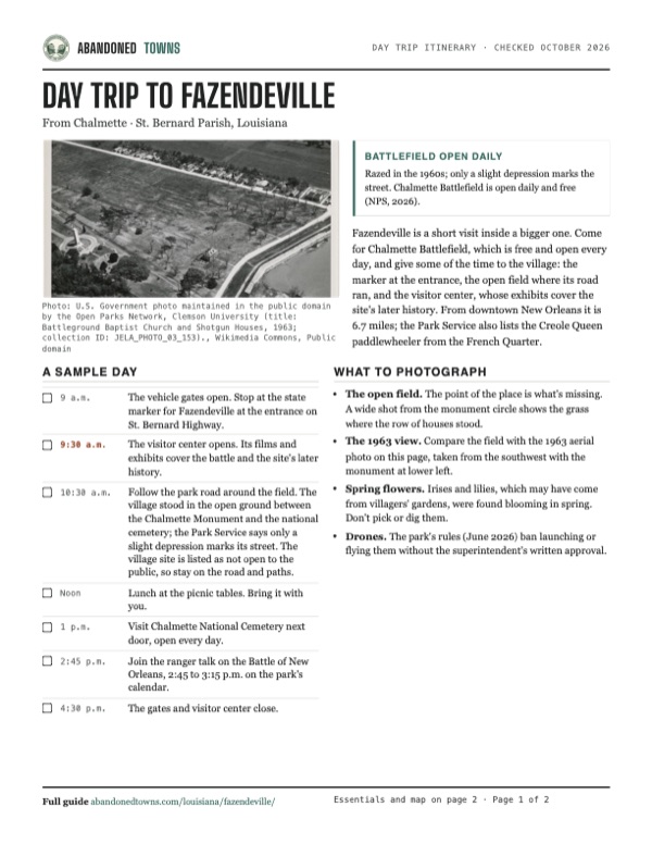
- The 1963 view. Compare the field with the 1963 aerial photo on this page, taken from the southwest with the monument at lower left.
- Spring flowers. Irises and lilies, which may have come from villagers' gardens, were found blooming in spring. Don't pick or dig them.
- Drones. The park's rules (June 2026) ban launching or flying them without the superintendent's written approval.
Map & directions
Getting there
Chalmette Battlefield is on St. Bernard Highway (LA 46) between New Orleans and Chalmette. Both routes enter the park, go around the circle at the Chalmette Monument and end a little beyond it on the park road, at the Park Service's map point for Fazendeville, about 160 yards west of the point Wikipedia gives. The Park Service also lists the Creole Queen paddlewheeler from the French Quarter to the battlefield.

Base map: USGS The National Map (public domain). Routes: OSRM on © OpenStreetMap contributors data (ODbL), computed October 2026. Times assume dry roads.
- From East Judge Perez Drive, turn left on Paris Road.0.4 mi
- Turn right on West St. Bernard Highway (LA 46).1.7 mi
- Turn left into the park on Chalmette National Park Scenic Road, go around the circle at the Chalmette Monument and follow the road a little farther to the village site.0.5 mi
- From Carondelet Street, take Canal Street and turn right on North Rampart Street.1.4 mi
- Continue on St. Claude Avenue.3.8 mi
- Bear left onto West St. Bernard Highway (LA 46).1.0 mi
- Turn right into the park on Chalmette National Park Scenic Road, go around the circle at the Chalmette Monument and follow the road a little farther to the village site.0.5 mi
Road and safety notes
- The routes are computed from OpenStreetMap and haven't been driven by us.
- The park's vehicle gates are open 9 a.m. to 4:30 p.m. Outside those hours you can walk in from sunrise to sunset. The park's rules ban parking inside a gated lot after hours.
- Metal detecting, digging and removing artifacts are prohibited on the battlefield under federal law.
- OpenStreetMap marks the line of old Fazendeville Road across the field as a path closed to the public.
Photos
Fazendeville in photos
Visitor reports
Been to Fazendeville?
Been there lately? Tell the next visitor what you found: whether you could get in, the state of the road and what's still standing. Photos are welcome. We read every report before it appears here.
Nearby
Other sites near Fazendeville
Straight-line distance from the townsite to other mapped sites in our Louisiana index.
- Good Hope24.7 mi W · St. Charles
- Frenier28.5 mi NW · St. John the Baptist
- Ruddock31.7 mi NW · St. John the Baptist
- Cheniere Caminada50.6 mi S · Jefferson
- Pilottown68.6 mi SE · Plaquemines
- Bayou Goula73.3 mi W · Iberville
- Burtville73.5 mi W · East Baton Rouge
- Burrwood76.7 mi SE · Plaquemines
Sources
Sources and credits
- Wikipedia, "Fazendeville, Louisiana", retrieved October 2026: the Fazende succession, the church, the 1888 census, the benevolent associations, the 1903 railroad offer, the fires of 1927 and 1949, the park campaign, the 1962 law, the road closure and demolition, the Lower Ninth Ward, the Jackson study, the irises, the 2021 marker, Abrams's $4,000 and $19,000 figures, coordinates.
- National Park Service, "Fazendeville", updated December 3, 2021: the 33 lots, the village's institutions and two churches, the land Fazende's by 1870, the 1963 decision, the sesquicentennial, "only a slight depression," and the listing of the site as not open to the public.
- National Park Service, "Places - Fazendeville", updated December 23, 2021: the 1867 founding, the 1857 inheritance, more than 200 people, the mid-1960s purchase, the move to the Ninth Ward.
- National Park Service, "Chalmette Battlefield", updated January 29, 2026, and its listing in the Park Service's visitor-center data, read October 21, 2026: gate hours for the battlefield and the cemetery, visitor center hours, free entry, amenities, address and phone, daily ranger talks, the Creole Queen, the metal detector rule.
- National Park Service, Superintendent's Compendium, Jean Lafitte NHP&P, updated June 25, 2026: visitor center open Memorial Day and Veterans Day and closed other federal holidays, the Mardi Gras rule, the cemetery gates at 9:30 a.m., and the bans on drones, games, pets, after-hours parking, the Malus-Beauregard House and the batture.
- National Park Service, Jean Lafitte calendar, read October 21, 2026: the daily 2:45 p.m. Battle of New Orleans talk at Chalmette, listed through 2027 with its holiday exceptions.
- National Park Service, "Fees & Passes", updated May 16, 2023: no admission fee.
- Eve Abrams, "The Defeat of Fazendeville", 64 Parishes, January 8, 2015, updated May 3, 2019: about 1870, about 30 families on 33 lots, the institutions, the 1939 park, eminent domain, a family forced out in 1963, $6,000 a home against $16,000, the move to the Lower Ninth Ward, Hurricane Betsy, "the scar on the land."
- Associated Press, "National park battlefield irises may mark razed Black homes", April 2022: the irises and crinum lilies, about 30 homes, the 2010 marker.
- U.S. Government photographs of 1958–1963 (Open Parks Network, Clemson University) and a 1922 Army Air Service aerial photo (National Archives), via Wikimedia Commons (in the photos).
- USGS Chalmette sheets, 1939, 1951, 1967 and 1998 (in the historic maps below): Fazende, Fazendeville and the park.
- Elevation: USGS 3D Elevation Program point query. Routes: OSRM on OpenStreetMap data, October 2026; OpenStreetMap also for the monument circle and the old road line. Not field-checked.
Photo and map credits
- Fazendeville, the monument and the cemetery from the air, March 25, 1963: U.S. Government photo maintained in the public domain by the Open Parks Network, Clemson University (title: Battleground Baptist Church and Shotgun Houses, 1963; collection ID: JELA_PHOTO_03_153)., Wikimedia Commons, Public domain
- A shotgun-style house, 1960: U.S. Government photo maintained in the public domain by the Open Parks Network, Clemson University (title: Shotgun-Style House, Fazendeville, Louisiana, 1960; collection ID: JELA_PHOTO_03_149)., Wikimedia Commons, Public domain
- Houses beyond the pecan grove, seen from the American rampart line, 1958 (George Statham): U.S. Government photo maintained in the public domain by the Open Parks Network, Clemson University (photographer: George Statham; title: Fazendeville Community from the American Rampart Line, Louisiana, 1958; collection ID: JELA_PHOTO_03_155)., Wikimedia Commons, Public domain
- Plank cabins, one with laundry drying, 1960: U.S. Government photo maintained in the public domain by the Open Parks Network, Clemson University (title: Cabins, One with Laundry Drying, Fazendeville, Louisiana, 1960; collection ID: JELA_PHOTO_03_148)., Wikimedia Commons, Public domain
- Chalmette Battlefield and the village from the air, July 10, 1922: Unknown author or not provided, Wikimedia Commons, Public domain
- A house and shed beside the gravel road, 1960: U.S. Government photo maintained in the public domain by the Open Parks Network, Clemson University (title: House and Shed, Fazendeville, Louisiana, 1960; collection ID: JELA_PHOTO_03_146)., Wikimedia Commons, Public domain
- Battle Ground Baptist Church and shotgun houses, 1960: U.S. Government photo maintained in the public domain by the Open Parks Network, Clemson University (title: Battleground Baptist Church and Shotgun Houses, 1960; collection ID: JELA_PHOTO_03_145)., Wikimedia Commons, Public domain
- A stock shed and fence, with a house at right, 1960: U.S. Government photo maintained in the public domain by the Open Parks Network, Clemson University (title: Fazendeville Stock Shed and Barbed Wire Fence, Louisiana, 1960; collection ID: JELA_PHOTO_03_141)., Wikimedia Commons, Public domain
- Area base map, topo and aerial imagery: USGS The National Map (public domain).
- Historic maps: USGS Historical Topographic Map Collection (public domain): Chalmette 1939, 1:31,680; Chalmette 1951, 1:24,000; Chalmette 1967, 1:24,000; Chalmette 1998, 1:24,000.