 Abandoned

Overview
A town one family bought

Forestville sits in the valley of the South Branch of the Root River in Fillmore County, between Preston and Wykoff. Robert Foster bought a claim here in 1853, and his brother-in-law Felix Meighen put up a log store that October, stocked with $700 of goods carried by oxcart, steamboat and wagon from Galena, Illinois. A surveyor platted 27 blocks in 1854 and the place took the name Forestville. By 1860 it had 20 houses, a school, two sawmills, a gristmill, a distillery, two hotels and a cabinet shop, according to the Minnesota Historical Society.
The Southern Minnesota Railroad chose another route in 1868, and two later lines missed the town too. People left for the railroad towns. The Meighens stayed. They lent money and goods on credit to farmers at high interest and took the land when the farmers could not pay, and they bought the lots that others sold cheaply on the way out. By 1889 they owned the whole town, and by 1890 Thomas Meighen and his father held more than 1,000 acres. Workers rented Meighen houses and were paid mostly in store credit. The post office closed in 1902, and when Thomas Meighen shut the store in 1910 Forestville stopped being a town.
Meighen, who died in 1936, wanted his boyhood home to become a state park, and in time it did. The Minnesota Historical Society has run the surviving buildings since 1978. Photos from 2013 show the store's shelves still stocked, and the house, granary and barns stand around it inside Forestville/Mystery Cave State Park, which the DNR runs.
Timeline
From Watertown to state park

- Levi Waterman registers a claim on an oak tree north of the south branch of the Root River. The spot is known as Watertown.
- Robert Foster buys Waterman's claim. In October Felix Meighen finishes a double-pen log store and stocks it with $700 of goods hauled from Galena, Illinois.
- A surveyor plats a townsite of 27 blocks around a public square, and the settlement is renamed Forestville. Wikipedia, citing Upham, says the name honors Forest Henry, Fillmore County's first probate judge.
- A post office opens. William Meighen goes into partnership with Major Foster and soon owns Foster's hotel, the Fremont House.
- The brick store and house next to the log store are finished. Felix Meighen's family lives there and raises seven children.
- MNHS describes 20 houses, a school, two sawmills, a gristmill, a distillery, two hotels and a cabinet shop. Its own pages give the population as 100 in one place and more than 150 in another.
- The Southern Minnesota Railroad bypasses Forestville and families start to leave. The population is 68 in 1870 and 55 in 1880.
- Buying out departing owners and foreclosing on indebted farmers, the Meighens now own the whole town.
- The Gillette-Hertzog Manufacturing Company of Minneapolis builds a steel truss bridge over the river, the third bridge at the crossing.
- Rural free delivery closes the post office.
- Thomas Meighen closes the store for good. The town is finished, though the land stays a working farm.
- Wikipedia says the legislature authorized a state park in 1949 to keep the townsite. MNHS dates the founding of Forestville State Park to 1963.
- The Forestville Townsite and Meighen Store are listed on the National Register of Historic Places.
- The Minnesota Historical Society takes over the five original buildings left (the store, the Meighen house, a granary, a carriage barn and an animal barn) with 18 acres, and opens a historic site.
- Mystery Cave is added to the park.
- A visitor center, rebuilt from a barn, opens.
- The 1899 bridge is lifted off County Road 118 for rehabilitation. A temporary pedestrian bridge carries visitors to the site.
- MNHS opens the buildings for self-guided tours from 1 to 7 p.m. during the park's Bat Festival.
A company town
Store credit and foreclosures

MNHS calls Forestville a company town, and the Meighens ran it like one. Farmers short of cash borrowed from them or bought on credit. When they could not pay, the debt became a note, usually at 10 to 40 percent a year and secured by a mortgage on the farm, and the Meighens foreclosed when crops failed. The farming moved from small wheat farms to one large Meighen operation in dairy cattle, corn, small grains and vegetables. MNHS says Thomas Meighen could have walked the roughly 25 miles to LeRoy without leaving his own land.
The family was also political. William Meighen ran for lieutenant governor on the Greenback ticket in 1877 and for governor in 1879, when he took 4 percent of the vote. Thomas joined the Farmers' Alliance and then the People's Party, and counted Ignatius Donnelly, the founder of Nininger, as a friend. MNHS says William Jennings Bryan visited and brought a buckeye tree that still stands on the lawn of the Meighen house.
What's left
Store, house and three barns


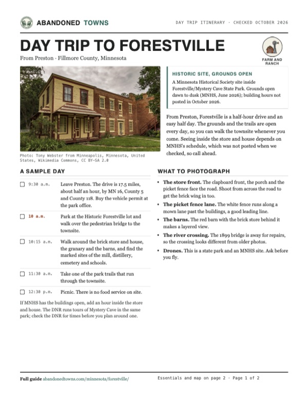
When MNHS took over in 1978 there were five original buildings: the store, the Meighen house, a granary, a carriage barn and an animal barn. They stand across the river from the parking lot. The store and house are one long building, a clapboard front with a porch joined to a brick wing, behind a white picket fence. MNHS also marks where the gristmill, the distillery, the cemetery and the schoolhouses stood, and park trails run through the site. The visitor center opened in 2001 in a building rebuilt from a barn.
The 1899 truss bridge that carried County Road 118 over the river is away for rehabilitation. MNHS says it will go back in its original place; we found no date for that. For now you park south of the river and walk over a temporary pedestrian bridge.
The 1954 USGS sheet in the historic maps below, at 1:250,000, shows only the wooded valley of the South Branch Root River between Wykoff and Preston, with no Forestville label. The 1965 sheet labels Forestville on the north bank where the road crosses the river, with the county road running north up the valley. The 1985 sheet shows the same crossing, with Forestville Creek joining from the west and quarries and Mystery Cave No. 2 farther southwest. Today's topo map marks the Townsite Loop trail in the fields south of the river.
- Meighen store and house (1857)
- Granary
- Carriage barn
- Animal barn
- Visitor center (2001, rebuilt from a barn)
- Sites of the gristmill, distillery, cemetery and schools
- 1899 bridge, away for rehabilitation


Historic maps
Forestville on USGS maps, 1954–1985
Crops from the USGS Historical Topographic Map Collection, centered on the townsite. Each sheet shows what surveyors mapped that year; compare them with today's topo and aerial on this page.

Day trip
Plan a day trip to Forestville from Preston
Take it with you
Day trip itinerary
The essentials, the sample day with boxes to tick, what to photograph and the coordinates, on two printable pages. Handy where there's no signal.
Download the PDF (644 KB)From Preston, Forestville is a half-hour drive and an easy half day. The grounds and the trails are open every day, so you can walk the townsite whenever you come. Seeing inside the store and house depends on MNHS's schedule, which was not posted when we checked, so call ahead.
A sample day
- Leave Preston. The drive is 17.5 miles, about half an hour, by MN 16, County 5 and County 118. Buy the vehicle permit at the park office.
- Park at the Historic Forestville lot and walk over the pedestrian bridge to the townsite.
- Walk around the brick store and house, the granary and the barns, and find the marked sites of the mill, distillery, cemetery and schools.
- Take one of the park trails that run through the townsite.
- Picnic. There is no food service on site.
If MNHS has the buildings open, add an hour inside the store and house. The DNR runs tours of Mystery Cave in the same park; check the DNR for times before you plan around one.
What to photograph and film
- The store front. The clapboard front, the porch and the picket fence face the road. Shoot from across the road to get the brick wing in too.
- The picket fence lane. The white fence runs along a mown lane past the buildings, a good leading line.
- The barns. The red barn with the brick store behind it makes a layered view.
- The river crossing. The 1899 bridge is away for repairs, so the crossing looks different from older photos.
- Drones. This is a state park and an MNHS site. Ask before you fly.
Map & directions
Getting there
Preston is the closest town, about half an hour away, and Rochester about an hour. Both routes end at the Historic Forestville parking lot south of the river, reached through the state park entrance on County Road 118, the way MNHS's own directions go. MNHS warns not to rely on online maps or GPS, which may send you to a closed bridge. From the lot, walk over the pedestrian bridge to the townsite.


Base map: USGS The National Map (public domain). Routes: OSRM on © OpenStreetMap contributors data (ODbL), computed October 2026. Times assume dry roads.
- From downtown Preston, take Fillmore Street, Saint Anthony Street and Saint Paul Street (County 17), then turn left on Kansas Street and Minnesota Road (US 52 / MN 16).1.4 mi
- Turn left on MN 16, the Historic Bluff Country Scenic Byway.9.1 mi
- Turn left on County Highway 5.4.1 mi
- Turn left on County Highway 118 into the state park and follow it to the Historic Forestville parking lot.2.9 mi
- From downtown Rochester, take 9th Street, 14th Avenue and 6th Street Southwest to US 52, take the ramp for US 63 and follow South Broadway Avenue south.9.6 mi
- Continue south on US 63, Highway 63 South.13.2 mi
- Turn left on US 63 / MN 16, the Historic Bluff Country Scenic Byway, and stay on MN 16 east.11.4 mi
- Turn right on County Highway 5.4.1 mi
- Turn left on County Highway 118 into the state park and follow it to the Historic Forestville parking lot.2.9 mi
Road and safety notes
- MNHS: "Do not rely on online maps or GPS" when visiting Historic Forestville, the state park or Mystery Cave, because they may send you to a closed bridge. Its directions use MN 16, County 5 and County 118.
- Stop at the park office on County 118 for a vehicle permit or daily parking fee, then drive three-quarters of a mile to the Historic Forestville lot south of the river and cross the pedestrian bridge on foot.
- Cell service is very limited in the valley (MNHS).
- The routes are computed from OpenStreetMap and haven't been driven by us. We have no dated source on road surfaces.
Photos
Forestville in photos
Visitor reports
Been to Forestville?
Been there lately? Tell the next visitor what you found: whether you could get in, the state of the road and what's still standing. Photos are welcome. We read every report before it appears here.
Farm and ranch
More farm and ranch ghost towns
The nearest, in other states.

 Guide
Cream
44.32, -91.77Buffalo County, Wisconsin
A crossroads in the Waumandee Creek valley that once had a hotel, a store, two saloons and the county's first fair. It shrank to a few families, and…
 Guide
Cheyenne Valley
43.67, -90.46Vernon County, Wisconsin
From 1855 nearly 150 African American settlers, many of them of mixed race, farmed this valley beside European immigrant neighbors and shared…
Nearby
Other sites near Forestville
Straight-line distance from the townsite to other mapped sites in our Minnesota index.
- Clear Grit10.2 mi NE · Fillmore
- Elliota16.8 mi SE · Fillmore
- Fairpoint50.7 mi NW · Goodhue
- Rice Lake52.5 mi NW · Dodge
- Florence58.9 mi N · Goodhue
- East Red Wing65.3 mi N · Goodhue
- Nininger84.9 mi NW · Dakota
- Itasca127.7 mi NW · Anoka
Sources
Sources and credits
- ghosttowns.com, "Forestville": fact sheet field (best time).
- Wikipedia, "Forestville, Minnesota", retrieved October 2026: settlement 1852, the Forest Henry name (citing Upham), post office 1855 to 1902, the 1868 railroad bypass, 55 people in 1880, the 1949 park authorization, the 1987 Mystery Cave addition, the 1973 National Register listing and coordinates.
- MNHS, "About Forestville", read October 20, 2026: Watertown, the 1853 store, the 1854 plat, the 1860 town and its two population figures, the company-town credit system, the railroads that missed the town, the 1870 and 1880 populations, the 1910 closing and the park.
- MNHS, "Timeline", read October 20, 2026: the Meighen family dates, the 1902 post office closure, 1963 park, the 1978 acquisition of five buildings and 18 acres, the 2001 visitor center and the 2008 flood closure.
- MNHS, "The Meighen Family", read October 20, 2026: the Greenback and People's Party campaigns, Donnelly, and the Bryan buckeye tree.
- MNHS, "Historic Bridge", read October 20, 2026: the three bridges, the 1899 Gillette-Hertzog bridge and its November 14, 2023 move for rehabilitation.
- MNHS, "Historic Forestville Provides Greater Access During Bat Festival", June 29, 2026: grounds typically open daily dawn to dusk, building access 1 to 7 p.m. on July 11, 2026, and the self-guided tour prices.
- MNHS, "Hours and Admission", read October 20, 2026: no hours posted, admission listed as free, state park vehicle permit required. Also "Directions and Parking" (the GPS warning, the route by MN 16, County 5 and County 118, the lot south of the river and the pedestrian bridge), "Amenities" (no restrooms or food service, picnics, leashed pets, limited cell service), "Accessibility" and "What to See and Do" (the marked sites, trails and DNR cave tours).
- MNHS, "Historic Forestville Opens with New Experiences for Visitors", June 12, 2024: the temporary pedestrian bridge on County Road 118. Its 2024 hours are not used here.
- Minnesota Statutes 85.055, read October 2026: $7 one-day and $35 annual state park permits.
- Photos: Wikimedia Commons, credited below each one. Elevation: USGS 3D Elevation Program point query. Routes: OSRM on OpenStreetMap data, October 2026. Not field-checked.
Photo and map credits
- The Meighen store and house, August 2017: Tony Webster from Minneapolis, Minnesota, United States, Wikimedia Commons, CC BY-SA 2.0
- The store and house behind their picket fence, July 2013: McGhiever, Wikimedia Commons, CC BY-SA 4.0
- The brick wing from the side, with its outside stair, August 2017: Tony Webster from Minneapolis, Minnesota, United States, Wikimedia Commons, CC BY-SA 2.0
- A mown lane beside the white picket fence, August 2017: Tony Webster from Minneapolis, Minnesota, United States, Wikimedia Commons, CC BY-SA 2.0
- Inside the store: crockery, lamps and a stove, September 2013: Minnesota Local History & Historic Preservation, Wikimedia Commons, CC BY-SA 2.0
- Visitors at the counter inside the store, September 2013: Minnesota Local History & Historic Preservation, Wikimedia Commons, CC BY-SA 2.0
- A furnished parlor at Historic Forestville, September 2013: Minnesota Local History & Historic Preservation, Wikimedia Commons, CC BY-SA 2.0
- A red barn with the brick store behind, September 2013: Minnesota Local History & Historic Preservation, Wikimedia Commons, CC BY-SA 2.0
- A weathered plank outbuilding, September 2013: Minnesota Local History & Historic Preservation, Wikimedia Commons, CC BY-SA 2.0
- The barn-style visitor center, September 2013: Minnesota Local History & Historic Preservation, Wikimedia Commons, CC BY-SA 2.0
- A steel truss bridge at Historic Forestville, September 2013: Minnesota Local History & Historic Preservation, Wikimedia Commons, CC BY-SA 2.0
- Area base map, topo and aerial imagery: USGS The National Map (public domain).
- Historic maps: USGS Historical Topographic Map Collection (public domain): Mason City 1954, 1:250,000; Fountain 1965, 1:24,000; Austin 1985, 1:100,000.