 Abandoned

Overview
Gold, rails and a fire

In 1862 five men heading for the California goldfields camped on Cracker Creek in the Blue Mountains. They found gold, stayed, and named their cabin Fort Sumter after the fort where the Civil War had begun. When the town applied for a post office the government would not accept the name, so the first postmaster, Joseph D. Young, added a "p". Legends of America dates that to 1874 and Wikipedia to 1883.
For thirty years Sumpter was a few log cabins. The town was platted in 1889, and in 1897 the narrow-gauge Sumpter Valley Railway arrived from Baker City. Deep-shaft mines with miles of tunnels opened around it, and the 1900 census counted 2,216 people. Legends of America counts three newspapers, seven hotels, sixteen saloons, two banks and an opera house at about that time, and puts the population above 3,500 a couple of years later.
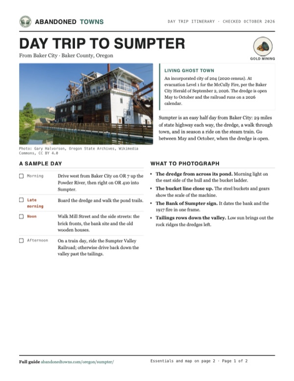
The mines were already giving out when fire broke out in the Capitol Hotel on August 13, 1917. Dynamite was used to stop it, but it burned about twelve blocks, nearly a hundred buildings. Little was rebuilt. Gold dredges then worked the Powder River valley below town from 1912 to 1954, and the last of them still floats in its pond at the edge of town as the centerpiece of the Sumpter Valley Dredge State Heritage Area. The 2020 census counted 204 people.
Video
Flea market weekend on Mill Street
A three-minute drive through Sumpter over the Fourth of July weekend, filmed from the dashboard. Cars are parked along both sides of the highway through town, vendor tents and canopies fill the lots beside the old wooden and brick buildings, and people walk between the stalls. An on-screen caption says the crowds left the creator without a campsite. The video has music but no narration.
 Play “A drive through Sumpter Oregon on the 4th of July @AdventureswithAngela” from YouTube
Timeline
Sumpter through the years

A 1963 sign on the bank site says the Bank of Sumpter was founded in 1899 with $10,000 in capital, burned in the fire of August 13, 1917, and that its vault is all that remains.
- Five men bound for the California goldfields camp on Cracker Creek, find gold and build a cabin they call Fort Sumter (Legends of America).
- Joseph D. Young becomes the first postmaster. The Post Office will not take the name Sumter, so the town becomes Sumpter. Legends of America gives 1874; Wikipedia gives 1883.
- The town is platted (Wikipedia).
- The narrow-gauge Sumpter Valley Railway reaches town from Baker City, and the mining boom takes off.
- The Bank of Sumpter opens, according to a sign on its site.
- The census counts 2,216 people. By then the town has three newspapers, an opera house, seven hotels and sixteen saloons. Legends of America puts the population above 3,500 a couple of years later.
- The first gold dredge in the valley is built just south of town (Historic Sumpter).
- On August 13 a fire that starts in the Capitol Hotel burns about 12 blocks, nearly 100 buildings. Dynamite is used to stop it. The town, already shrinking as the mines played out, is never fully rebuilt.
- The census counts 219.
- The third and last dredge, begun in 1934, starts work. It runs almost around the clock until 1954 and recovers an estimated $4 million or more in gold (Oregon State Parks).
- The last train runs on the Sumpter Valley line, in April (Legends of America). Passenger service had ended about ten years earlier.
- Dredging stops in August. The dredge is left where it stopped, in a pond at the edge of town.
- The census counts 204 residents, the same as in 2010.
- On August 16 a fire destroys the Elkhorn Saloon, a wooden building from about 1900 (Blue Mountain Eagle).
- The McCully Fire burns in the mountains nearby. On September 2 the Baker City Herald reports Sumpter at Level 1 ("be ready") and the byway to Granite open.
Sumpter Valley Dredge
The dredge that turned over the valley

A gold dredge is a floating mill. A chain of steel buckets digs gravel from the front of its pond, the hull washes the gold out, and a stacker dumps the stones out the back, so the dredge carries its pond across the valley and leaves long rows of rock behind it. The first dredge in the Sumpter Valley was built in 1912 (Historic Sumpter). The one that survives was begun in 1934 and ran, Oregon State Parks says, almost continuously from 1935 to 1954. The parks department estimates it recovered more than $4 million in gold.
Historic Sumpter writes that wartime rules stopped it in 1942, that it restarted in 1945, and that when it shut down for good in August 1954 its company was $100,000 in debt. The tailings piles it left run down the valley toward McEwen and are plain on the aerial view below.
Visitors are welcome aboard from May to October. You can walk the decks yourself or join a ranger-led tour, which runs on weekends only. About a mile and a half of trails wind through the wetlands around the dredge, with several viewing platforms (Oregon State Parks).
What's left
What you'll see


Sumpter is a living town, not an empty one. A visitor's report from March 2014 found many old buildings standing, some being refurbished, and new ones going up; the dredge park and depot close in winter and the town largely shuts down then. The Oregon State Archives photographed a row of weathered wooden houses and stores and a few brick fronts in July 2019, shown in the gallery below. The Elkhorn Saloon, one of the larger old wooden buildings, burned in August 2023.
The Sumpter Valley Railroad runs excursion trains to the Sumpter station at the entrance to the dredge park on Austin Street. Its 2026 calendar has trains leaving Sumpter on Memorial Day, Fourth of July and Halloween weekends (October 31 and November 1), and from McEwen, down the valley, on selected weekends from June to October and in December. Big flea markets fill the town on Memorial Day, Fourth of July and Labor Day weekends; a video posted July 7, 2026 shows the highway through town lined with parked cars and vendor tents over the Fourth.
The 1901 Sumpter topographic sheet below shows the town as a dense grid where Cracker Creek meets the Powder River, with the railroad running southeast down the valley. By the 1955 sheet the valley below town is drawn as dredge tailings toward McEwen, with the ghost towns of Bourne up Cracker Creek to the north and Whitney to the southwest.
- Sumpter Valley gold dredge (state heritage area)
- Old wooden houses, stores and barns
- Brick store fronts
- Bank of Sumpter site and vault
- Dredge tailings down the valley
- Sumpter Valley Railroad station


Historic maps
Sumpter on USGS maps, 1901–1987
Crops from the USGS Historical Topographic Map Collection, centered on the townsite. Each sheet shows what surveyors mapped that year; compare them with today's topo and aerial on this page.

Day trip
Plan a day trip to Sumpter from Baker City
Take it with you
Day trip itinerary
The essentials, the sample day with boxes to tick, what to photograph and the coordinates, on two printable pages. Handy where there's no signal.
Download the PDF (570 KB)Sumpter is an easy half day from Baker City: 29 miles of state highway each way, the dredge, a walk through town, and in season a ride on the steam train. Go between May and October, when the dredge is open.
A sample day
- Drive west from Baker City on OR 7 up the Powder River, then right on OR 410 into Sumpter.
- Board the dredge and walk the pond trails.
- Walk Mill Street and the side streets: the brick fronts, the bank site and the old wooden houses.
- On a train day, ride the Sumpter Valley Railroad; otherwise drive back down the valley past the tailings.
What to photograph and film
- The dredge from across its pond. Morning light on the east side of the hull and the bucket ladder.
- The bucket line close up. The steel buckets and gears show the scale of the machine.
- The Bank of Sumpter sign. It dates the bank and the 1917 fire in one frame.
- Tailings rows down the valley. Low sun brings out the rock ridges the dredges left.
Map & directions
Getting there
Baker City, on I-84, is the nearest city. From there OR 7 follows the Powder River southwest up the Sumpter Valley, and OR 410 turns off into Sumpter. From Boise, take I-84 northwest to Baker City first. The routes were computed from OpenStreetMap and haven't been driven by us.


Base map: USGS The National Map (public domain). Routes: OSRM on © OpenStreetMap contributors data (ODbL), computed October 2026. Times assume dry roads.
- From downtown, take Auburn Avenue, 2nd Street and Dewey Avenue to OR 7.0.6 mi
- Follow OR 7, the Whitney Highway and Sumpter Stage Highway, southwest up the valley.25.3 mi
- Turn right on the Sumpter Valley Highway, OR 410, which becomes South Mill Street.3.1 mi
- Turn right on Auburn Street.0.2 mi
- From downtown Boise, take Main Street, 6th Street and Front Street to the Boise Connector (US 20/26).0.7 mi
- Follow the Boise Connector to I-84.4.8 mi
- Take I-84 west and north to Baker City.120.1 mi
- Take the off-ramp to US 30, then Estes Street.2.5 mi
- Turn left on Dewey Avenue and follow OR 7 southwest up the valley.25.7 mi
- Turn right on OR 410, which becomes South Mill Street.3.1 mi
- Turn right on Auburn Street.0.2 mi
Road and safety notes
- Both routes follow state highways, OR 7 and OR 410. Winters are cold and snowy, and the town largely shuts down then (visitor report, March 2014).
- On September 2, 2026, the Baker City Herald reported the Elkhorn Drive byway open between Sumpter and Granite, with a 15-mile stretch farther north closed by the McCully Fire.
- Forest Service fire closures cover national forest land around the 2026 fires. Check the Wallowa-Whitman alerts page before leaving the highway.
- Sumpter is on the Elkhorn Drive Scenic Byway loop with Baker City and Granite.
Photos
Sumpter in photos
Visitor reports
Been to Sumpter?
Been there lately? Tell the next visitor what you found: whether you could get in, the state of the road and what's still standing. Photos are welcome. We read every report before it appears here.
Gold mining
More gold mining ghost towns
The nearest in Oregon.

 Guide
Granite
44.81, -118.42Grant County, Oregon
Gold found on the Fourth of July in 1862 gave this camp an early name, Independence. Eighty years of mining ended in 1942, and 32 people lived among…
 Guide
Cornucopia
45.01, -117.19Baker County, Oregon
A gold camp at the head of Pine Valley that produced roughly $18 million to $20 million in precious metals. The war closed its mines in 1942, and the…
Nearby
Other sites near Sumpter
Straight-line distance from the townsite to other mapped sites in our Oregon index.
- Bourne5.4 mi N · Baker
- McEwen5.5 mi SE · Baker
- Whitney7.5 mi SW · Baker
- Granite11.7 mi W · Grant
- Auburn12.8 mi E · Baker
- Cabell City13.3 mi NW · Grant
- Robinsonville14.3 mi W · Grant
- Austin17.7 mi SW · Grant
Sources
Sources and credits
- ghosttowns.com, "Sumpter": fact sheet (road, climate, best time), flea market weekends, and a visitor's dated report of March 26, 2014.
- Wikipedia, "Sumpter, Oregon", read October 2026: name, 1883 postmaster, 1889 platting, the railway, census counts (2,216 in 1900, 204 in 2010 and 2020), the 1917 fire and dynamite, the dredge years.
- Legends of America, "Sumpter, Oregon – Queen City Ghost Town", Kathy Alexander, updated September 2026: the 1862 camp, 1874 postmaster, hotels, saloons, banks and newspapers, the 3,500 estimate, the Capital Hotel and nearly 100 buildings, the railway's end in 1947.
- Oregon State Parks, Sumpter Valley Dredge State Heritage Area, read October 29, 2026: season, weekend tours, trails, years of operation, gold estimate, phone.
- Oregon State Parks, day-use parking permits, read October 29, 2026: permit prices.
- Historic Sumpter, dredge history, copyright 2022: the 1912 first dredge, work begun on the last dredge in 1934, the 1942 stop and 1945 restart, the 1954 shutdown and debt.
- Sumpter Valley Railroad, 2026 calendar, read October 29, 2026, and home page: train dates, the Sumpter station on Austin Street, phone.
- Adventures with Angela, "A drive through Sumpter Oregon on the 4th of July", YouTube, posted July 7, 2026: the video on this page; the town during the Fourth of July flea market.
- Blue Mountain Eagle, "Fire destroys Elkhorn Saloon in Sumpter", August 16, 2023.
- Baker City Herald, "McCully Fire continues NW spread", September 2, 2026: Sumpter at Level 1, byway open between Sumpter and Granite.
- Wallowa-Whitman National Forest alerts: current fire closures.
- Bank of Sumpter site sign, as photographed by the Oregon State Archives in July 2019 (Wikimedia Commons): the 1899 bank and the 1917 fire.
- Coordinates: Wikipedia (from USGS GNIS). Elevation: USGS 3D Elevation Program point query. Routes: OSRM on OpenStreetMap data, October 2026.
Photo and map credits
- The dredge in its pond, July 2012: Gary Halvorson, Oregon State Archives, Wikimedia Commons, CC BY 4.0
- Main Street, May 2011: Richard Bauer, Wikimedia Commons, CC BY 2.0
- A two-story house with a balcony porch, July 2019: Gary Halvorson, Oregon State Archives, Wikimedia Commons, CC BY 4.0
- Two weathered wooden buildings, July 2019: Gary Halvorson, Oregon State Archives, Wikimedia Commons, CC BY 4.0
- A brick building painted "Welcome to the Sumpter Museum and Public Library", July 2019: Gary Halvorson, Oregon State Archives, Wikimedia Commons, CC BY 4.0
- A wooden cottage with a front porch, July 2019: Gary Halvorson, Oregon State Archives, Wikimedia Commons, CC BY 4.0
- A two-story brick store, July 2019: Gary Halvorson, Oregon State Archives, Wikimedia Commons, CC BY 4.0
- An old barn in a field, July 2019: Gary Halvorson, Oregon State Archives, Wikimedia Commons, CC BY 4.0
- A false-front wooden store with a long porch, July 2019: Gary Halvorson, Oregon State Archives, Wikimedia Commons, CC BY 4.0
- A two-story brick building painted "Sumpter Trading Post", May 2007: Gary Halvorson, Oregon State Archives, Wikimedia Commons, CC BY 4.0
- "Groceries, Dry Goods" and "Sumpter Supply" painted on a brick wall, May 2007: Gary Halvorson, Oregon State Archives, Wikimedia Commons, CC BY 4.0
- The Black Market antiques and second-hand shop, a weathered board building, July 2019: Gary Halvorson, Oregon State Archives, Wikimedia Commons, CC BY 4.0
- The Bank of Sumpter site sign, July 2019: Gary Halvorson, Oregon State Archives, Wikimedia Commons, CC BY 4.0
- The dredge's bucket ladder, September 2020: Gary Halvorson, Oregon State Archives, Wikimedia Commons, CC BY 4.0
- Topo map, area base map and aerial imagery: USGS The National Map (public domain).
- Historic maps: USGS Historical Topographic Map Collection (public domain): Sumpter 1901, 1:125,000; Canyon City 1955, 1:250,000; Bates 1987, 1:100,000.