 Abandoned

Overview
A Massachusetts colony on the Ashley

Dorchester stood on a neck of land between the Ashley River and Dorchester Creek, about 15 miles upriver from Charleston. Its first settlers were Congregationalists from Dorchester, Massachusetts, led by Rev. Joseph Lord. They reached Charles Town at the end of 1695 and took up the 1,800 acres once granted to John Smith. Wikipedia dates their first service there to early 1696; the state park says the town was settled in 1697.
The river and the roads to Charleston and the interior made it a trading town. Rice, indigo and trade with Native Americans brought money through it, and it had a fair from 1723 and a free school from 1734. The Anglican parish church of St. George went up in the center of town around 1719, and its bell tower was added around 1751. In the 1750s, fear of a French attack brought a fort and powder magazine built of tabby, a concrete of lime, sand and oyster shell.
The sources disagree on when the town died. Wikipedia's article on the town says the townspeople left in 1751, most of them for Midway, Georgia. The state park and Wikipedia's article on the park describe a town that kept trading until the Revolution, with about 40 houses in 1781. Even the park's pages differ: its front page says the town was abandoned at the start of the war, its history page says after it. Soldiers of both sides held Dorchester during the war, and the British burned the church. Summerville grew up on higher, drier ground nearby, and people hauled away Dorchester's bricks to build it.
The woods that took the site kept most of the town under the ground. Archaeologists are still digging there, and the park runs programs where visitors can watch.
Video
Bell tower, dig site, fort and wharf
A traveler tours the historic site on a summer day: the bell tower of St. George's and its churchyard, the park's interpretive signs and model of the town, and an archaeological dig with its sifting screens, where he describes what the archaeologist and historian he met told him. Then he walks through the tabby fort and its magazine ruins and down to the river, where the logs of a wharf show at low tide. What the archaeologists found is as the creator retells it; the history below follows the park and our other sources.
 Play “Uncovering a 1700's Colonial Town” from YouTube
Timeline
From Boshoe Creek to state park
- John Smith receives a grant of 1,800 acres on Boshoe Creek, the land the town later stands on. It lapses after his death in 1682.
- Rev. Joseph Lord leads Congregationalists from Dorchester, Massachusetts, to the Ashley River. Wikipedia dates their arrival in Charles Town to December 20, 1695, and their first service to early 1696; the state park gives 1697 for the settlement.
- St. George's Anglican parish is set up; the state marker dates the parish to 1717 and the brick church to August 1719.
- Lord returns to Massachusetts.
- A fair is established in 1723 and a free school in 1734.
- The church's bell tower is added: 1751 by the state park's account, "before 1753" by the state marker. Wikipedia's article on the town says the townspeople abandoned the village in 1751, most of them for Midway, Georgia.
- Work starts on the tabby fort and powder magazine above the river. Wikipedia gives 1757 to 1760.
- Dorchester becomes an American military post. Francis Marion commands the garrison for a time.
- After Charleston falls, the British hold the town. They burn the church and leave in December 1781, when American troops advance. The town has about 40 houses that year.
- The town is abandoned after the war, by the park's history page; the park's front page says it was abandoned at the start of the war. Summerville grows on higher ground nearby, and bricks are carried off for new buildings.
- The Charleston earthquake splits the bell tower. It is held together with iron straps until repairs in the early 1960s.
- The state leases 20.56 acres from Westvaco in 1960, gets 0.94 acre from the Episcopal Church, and acquires more Westvaco land in 1969 and 1982. The site goes on the National Register on December 2, 1969.
What's left
Fort, tower and churchyard


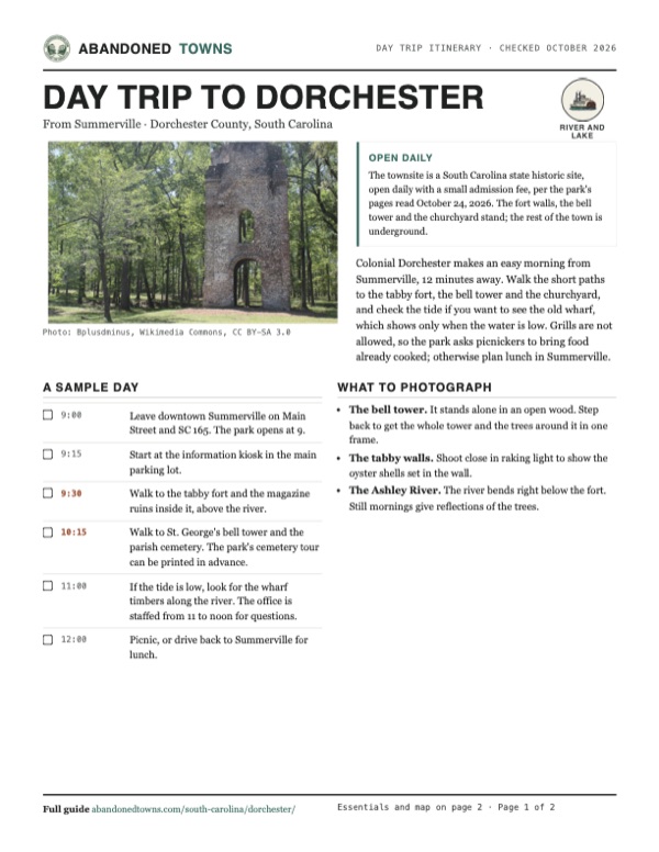
Three things stand above ground. The tabby fort overlooks the river; the state park calls it the best-preserved tabby fortification in the country. After the war the fort held a tile yard, and the magazine inside it was used as a kiln. The brick bell tower of St. George's stands in the woods near the cemetery of St. George's Parish. Its sanctuary is gone, taken apart for bricks. At low tide, the remains of a log shipping wharf show in the river.
A short interpretive trail with a kiosk and exhibits links the ruins and explains what the digs have found. The park has a printable walking tour and a self-guided cemetery tour. Geocaching is allowed; metal detectors are not.
The state marker by the tower, photographed in 2009, gives slightly different dates from the park: a parish of 1717, a brick church begun in August 1719 and enlarged in the 1730s, and a tower built before 1753 that held four bells in 1766.
The Old White Meeting House, the Congregationalists' church, is a separate site. It burned in 1781, was rebuilt, and was wrecked by the 1886 earthquake. Wikipedia says its ruins and cemetery belong to Summerville Presbyterian Church; we have not checked visiting arrangements there.
The 1920 and 1944 Ravenels sheets below print "Old Dorchester" and "Old Fort" at the bend of the Ashley, where Dorchester Creek comes in; the 1920 sheet also names Bacon Bridge upstream. The 1957 Stallsville sheet shows "Old Fort Dorchester" by the river, a cemetery north of it, and SC 642 crossing above. By 1986 the suburbs of Summerville reach the north side of Dorchester Road.
- Tabby fort and powder magazine (1757)
- St. George's Church bell tower (about 1751)
- Cemetery of St. George's Parish
- Log wharf remains, seen at low tide
- Interpretive trail and kiosk


Historic maps
Dorchester on USGS maps, 1920–1986
Crops from the USGS Historical Topographic Map Collection, centered on the townsite. Each sheet shows what surveyors mapped that year; compare them with today's topo and aerial on this page.

Day trip
Plan a day trip to Dorchester from Summerville
Take it with you
Day trip itinerary
The essentials, the sample day with boxes to tick, what to photograph and the coordinates, on two printable pages. Handy where there's no signal.
Download the PDF (644 KB)Colonial Dorchester makes an easy morning from Summerville, 12 minutes away. Walk the short paths to the tabby fort, the bell tower and the churchyard, and check the tide if you want to see the old wharf, which shows only when the water is low. Grills are not allowed, so the park asks picnickers to bring food already cooked; otherwise plan lunch in Summerville.
A sample day
- Leave downtown Summerville on Main Street and SC 165. The park opens at 9.
- Start at the information kiosk in the main parking lot.
- Walk to the tabby fort and the magazine ruins inside it, above the river.
- Walk to St. George's bell tower and the parish cemetery. The park's cemetery tour can be printed in advance.
- If the tide is low, look for the wharf timbers along the river. The office is staffed from 11 to noon for questions.
- Picnic, or drive back to Summerville for lunch.
What to photograph and film
- The bell tower. It stands alone in an open wood. Step back to get the whole tower and the trees around it in one frame.
- The tabby walls. Shoot close in raking light to show the oyster shells set in the wall.
- The Ashley River. The river bends right below the fort. Still mornings give reflections of the trees.
Map & directions
Getting there
Colonial Dorchester is on the south side of Dorchester Road (SC 642), a few miles south of downtown Summerville. From Summerville, take Main Street and SC 165 to Dorchester Road. From Charleston, take I-26 to exit 215 and follow Dorchester Road west. Both routes end on the park road.

Base map: USGS The National Map (public domain). Routes: OSRM on © OpenStreetMap contributors data (ODbL), computed October 2026. Times assume dry roads.
- From downtown Summerville, turn left on South Main Street (US 17 Alternate).1.1 mi
- Turn left on East Carolina Avenue, which becomes Old Trolley Road (SC 165).4.0 mi
- Turn right on Dorchester Road (SC 642), then sharp left on Old Dorchester State Park Road to the park.0.7 mi
- From Broad Street, turn left on Meeting Street.2.1 mi
- Take the ramp onto I-26 and leave it at exit 215.4.7 mi
- Turn left on Dorchester Road (SC 642), then sharp left on Old Dorchester State Park Road to the park.14.1 mi
Road and safety notes
- The routes follow town streets, SC 165, I-26 and Dorchester Road (SC 642) to the park road.
- The park's own directions from I-26 use exit 199-A and US 17 through Summerville to SC 165 and Dorchester Road.
- There is no river access for boats at the park.
Photos
Colonial Dorchester in photos
Visitor reports
Been to Dorchester?
Been there lately? Tell the next visitor what you found: whether you could get in, the state of the road and what's still standing. Photos are welcome. We read every report before it appears here.
River and lake
More river and lake ghost towns
The nearest in South Carolina.

 Guide
Hamburg
33.48, -81.96Aiken County, South Carolina
A cotton port and railroad terminus founded in 1821 across the Savannah River from Augusta. After the Civil War it was a town of freedmen, and in…
 Guide
Andersonville
34.45, -82.86Anderson County, South Carolina
A river port founded in 1801 where the Tugaloo and Seneca meet to form the Savannah. Floods and the railroad emptied it in the 1800s, and Lake…
Nearby
Other sites near Dorchester
Straight-line distance from the townsite to other mapped sites in our South Carolina index.
- Clementia13.3 mi S · Charleston
- Strawberry Chapel and Childsbury Town Site16.9 mi NE · Berkeley
- Ferguson34.1 mi N · Orangeburg
- Purrysburg71.3 mi SW · Jasper
- Dunbarton81.0 mi W · Barnwell
- Meyers Mill84.1 mi W · Barnwell
- Ellenton92.2 mi W · Aiken
- Springville97.8 mi N · Darlington
Sources
Sources and credits
- South Carolina State Parks, Colonial Dorchester State Historic Site, with its FAQs, history, things to do, unique features and area info pages, read October 24, 2026: hours, office hours, admission, Christmas closing, restrooms, address, the 1697 settlement, abandonment at the start of the war (front page), the 1719 church and 1751 tower, the 1757 fort, Francis Marion, abandonment after the Revolution (history page), the land leased, donated and acquired 1960 to 1982, the wharf at low tide, trails, picnics without grills, fishing, metal detectors, pets, no boat access.
- Wikipedia, "Dorchester, South Carolina" (revision of June 2, 2025): John Smith's grant, Joseph Lord and the voyage from Boston, the 1696 founding, Lord's return in 1720, the 1751 departure for Midway, Georgia, and the Old White Meeting House.
- Wikipedia, "Colonial Dorchester State Historic Site" (revision of June 29, 2026): the fair of 1723, the free school of 1734, about 40 houses in 1781, the church burned by the British, the 1886 earthquake damage and 1960s repair, the fort of 1757 to 1760 and its later tile yard, Summerville and the reused bricks, the 1969 National Register listing.
- State marker "Parish Church of St. George, Dorchester", as photographed July 19, 2009: the 1717 parish, the church begun in August 1719, the tower built before 1753 and its four bells in 1766.
- USGS GNIS, "Dorchester (historical)", feature 1241079: coordinates.
- Mobile Instinct 2, "Uncovering a 1700's Colonial Town", YouTube, posted July 22, 2024: the video on this page; the bell tower, churchyard, dig site, tabby fort and the wharf logs at low tide.
- Historic maps: USGS Ravenels 1920 and 1944, Stallsville 1957 and Walterboro 1986 sheets. Elevation: USGS 3D Elevation Program point query. Routes: OSRM on OpenStreetMap data, October 24, 2026.
Photo and map credits
- St. George's bell tower in the woods, 2014: Bplusdminus, Wikimedia Commons, CC BY-SA 3.0
- Inside the tabby fort, 2014: Bplusdminus, Wikimedia Commons, CC BY-SA 3.0
- A tabby wall of the fort, 2014: Bplusdminus, Wikimedia Commons, CC BY-SA 3.0
- Water's edge at the townsite, 2014: Bplusdminus, Wikimedia Commons, CC BY-SA 3.0
- The tabby walls of Fort Dorchester, July 2021: Qbkwldr, Wikimedia Commons, CC BY-SA 4.0
- The state marker "Parish Church of St. George, Dorchester," July 2009: Lazyksaw, Wikimedia Commons, CC BY-SA 3.0
- The bell tower above the churchyard, July 2009: Lazyksaw, Wikimedia Commons, CC BY-SA 3.0
- The bell tower, December 2011: Vitugglan, Wikimedia Commons, CC BY-SA 4.0
- Topo map, area base map and aerial imagery: USGS The National Map (public domain).
- Historic maps: USGS Historical Topographic Map Collection (public domain): Ravenels 1920, 1:62,500; Ravenels 1944, 1:62,500; Stallsville 1957, 1:24,000; Walterboro 1986, 1:100,000.