 Abandoned
Overview
A town on the line

Glenrio started in 1903 as a Rock Island Railroad siding on the Texas–New Mexico line. Its business moved to the highway early. Motorists on the Ozark Trail were stopping by 1917, and in 1926 the trail became Route 66. The town sat across the state line, so its bars were on the New Mexico side and its gas stations on the Texas side, and the post office was in New Mexico.
The 1950s were the high point. A Texaco station, the Brownlee Diner, the State Line Café and the Texas Longhorn Motel all opened between 1950 and 1955. The Park Service says the State Line Motel's sign reads "Motel, First in Texas" to drivers coming in from the west and "Motel, Last in Texas" to those coming from the east. Interstate 40 bypassed the town in 1973. The Ehresman family's café and motel closed in 1976, and the railroad tracks came out in the 1980s.
The National Park Service counts 17 abandoned buildings, most of them plain concrete and stucco. In 2007 the town became the Glenrio Historic District, and the 2010 census counted no one living there. Glenrio is a stop for Route 66 travelers, seen from the old road.
Then and now
Glenrio from the air, 1983 and 2022
On June 3, 1983, almost ten years after Interstate 40 bypassed Glenrio in 1973, the federal National High Altitude Photography program photographed the town on color infrared film, which shows plants in red. Trees and buildings still lined old Route 66 on both sides of the state line, and the Rock Island railroad's line lay just south of the road. The second photograph comes from the federal farm survey of May 26, 2022.
The interstate, the old road and the state-line road are where they were. The State Line Café and the Texas Longhorn Motel had closed in 1976, and the railroad tracks were taken up in the 1980s. Fewer trees stand along the road, most of the buildings north of it are empty, and the 2010 census counted no one living in Glenrio.


1983: U.S. Geological Survey NHAP, via the Texas Geographic Information Office, source, Public domain. 2022: U.S. Department of Agriculture NAIP, via USGS The National Map, source, Public domain. Both photographs cover the same 1.2 by 0.9 km and were lined up on 45 matched ground features spread over the frame, to within about half a metre on average, and checked by eye on the roads. Labels: the interstate, the old road, the businesses and the railroad from this guide's sources; the state line from today's USGS topo; the rest from what the photographs show.
Timeline
Railroad, highway, bypass

- The Rock Island Railroad lays out a siding on the Texas–New Mexico line, called Rock Island.
- The railroad renames it Glenrio, from Scots glen and Spanish río.
- A hotel takes in motorists on the Ozark Trail by 1917, and trail markers go up by 1919.
- The Ozark Trail becomes US Route 66. Business shifts from the railroad to the highway.
- By the 1930s Route 66 is a paved two-lane road.
- Part of The Grapes of Wrath is said to have been filmed at Glenrio. The Park Service calls this local lore it can't confirm.
- A Texaco station (1950), the Brownlee Diner, later Little Juarez Café (1952), the State Line Café and station (1953) and the Texas Longhorn Motel (1955) open.
- Interstate 40 bypasses the town. Sources give 1973 and 1975 for the bypass and the start of the decline.
- Homer Ehresman's State Line Café and Texas Longhorn Motel close.
- The Rock Island tracks are taken up.
- The Glenrio Historic District is listed on the National Register of Historic Places.
- The census counts no residents.
Record and claims
Stories and dates
The Grapes of Wrath. Wikipedia says part of the 1940 film was shot at Glenrio. The National Park Service says local lore ties a welcome station to the film but that this can't be confirmed.
The bypass. Wikipedia gives September 1973 for the I-40 bypass and also says the decline began in 1975. The Park Service says 1975.
Which state. The state line was meant to follow the 103rd meridian, but the 1859 survey that marked it set the border between 2.29 and 3.77 miles too far west. Texas taxes and governs the strip, and a New Mexico bill to sue for it did not become law.
What's left
Along the old road


The historic district follows the old Route 66 roadbed, now Loop 504 on the Texas side, and the properties to its north. The Park Service lists the State Line Motel, the State Line Bar, the Little Juarez Diner and the Texas Longhorn Motel, along with a well-preserved 1950s Texaco station and diner. Wikipedia adds the post office, built around 1935 on the New Mexico side. Many buildings are overgrown, missing windows or ringed with debris.
The Park Service names two buildings as the last occupied: the Joseph Brownlee House and an office in the Texas Longhorn Motel. Treat every building as private. Look from the road and don't go inside.
- Texas Longhorn Motel
- State Line Motel and Bar
- Little Juarez Diner
- Texaco station
- Post office
- Route 66 roadbed


Historic maps
Glenrio on USGS maps, 1954–1968
Crops from the USGS Historical Topographic Map Collection, centered on the townsite. Each sheet shows what surveyors mapped that year; compare them with today's topo and aerial on this page.

Day trip
Plan a day trip to Glenrio from Tucumcari
Take it with you
Day trip itinerary
The essentials, the sample day with boxes to tick, what to photograph and the coordinates, on two printable pages. Handy where there's no signal.
Download the PDF (498 KB)Glenrio is a short stop, best paired with a Route 66 drive. From Tucumcari it's 45 minutes east on I-40. Walk the old road, photograph the motels and cafes from it, and drive back. Bring food and water.
A sample day
- Drive east from Tucumcari on I-40.
- Walk the old roadbed from the Texas Longhorn Motel west past the Texaco station into New Mexico.
- Head back to Tucumcari for lunch, or continue east to Amarillo.
What to photograph and film
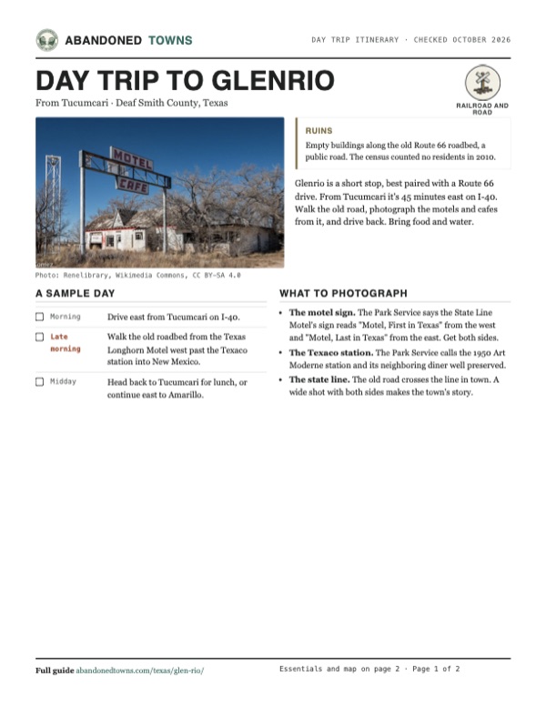
- The motel sign. The Park Service says the State Line Motel's sign reads "Motel, First in Texas" from the west and "Motel, Last in Texas" from the east. Get both sides.
- The Texaco station. The Park Service calls the 1950 Art Moderne station and its neighboring diner well preserved.
- The state line. The old road crosses the line in town. A wide shot with both sides makes the town's story.
Map & directions
Getting there
Tucumcari, New Mexico, is the nearest town, about 45 minutes west on I-40. From Amarillo it's a little over an hour west on I-40 to exit 0, the last exit in Texas. Both routes end on the old Route 66 roadbed through town.


Base map: USGS The National Map (public domain). Routes: OSRM on © OpenStreetMap contributors data (ODbL), computed October 2026. Times assume dry roads.
- From central Tucumcari, take South 1st Street, NM 209, to I-40.1.8 mi
- Follow I-40 east toward Texas.40.9 mi
- Exit and turn right on Old Route 66, Business I-40, into Glenrio.0.8 mi
- From downtown Amarillo, take North Pierce Street to I-40.2.1 mi
- Follow I-40 west to exit 0.69.3 mi
- Take Old Route 66, Business I-40, into Glenrio.1.2 mi
Road and safety notes
- The old pavement on the New Mexico side is broken and grassed over; an undated listing suggests 4WD there.
- Buildings are fragile and some are lived in or owned. Stay on the road and don't go inside.
- Winters on the high plains bring snow. Fall is the best season.
Photos
Glenrio in photos
Visitor reports
Been to Glenrio?
Been there lately? Tell the next visitor what you found: whether you could get in, the state of the road and what's still standing. Photos are welcome. We read every report before it appears here.
Railroad and road
More railroad, road and fort ghost towns
The nearest in Texas.

 Guide
Fort Griffin
32.93, -99.23Shackelford County, Texas
Fort ruins overlook the Clear Fork of the Brazos. Below the military post, merchants and buffalo hunters built a separate civilian town.
 Guide
Lobo
30.81, -104.75Culberson County, Texas
A Southern Pacific water stop became a cotton-farming town on US 90. Its empty motel and roadside buildings survive south of Van Horn.
Nearby
Other sites near Glenrio
Straight-line distance from the townsite to other mapped sites in our Texas index.
Sources
Sources and credits
- ghosttowns.com, "Glen Rio": fact sheet fields (road, 4WD advice for the New Mexico side, climate, best time, 1938 population).
- Wikipedia, "Glenrio, New Mexico and Texas", retrieved October 2026: founding, name, building dates, 1976 closures, bypass, border survey, National Register listing, 2010 census, post office, film claim, current business, exit 0.
- National Park Service, "Glenrio Historic District," updated May 9, 2026: Ozark Trail hotel and markers, 17 buildings, the State Line Motel sign, occupied buildings, condition, Loop 504, 1975 bypass, film lore, the detour off I-40.
- Ri Wolf, "Two states, one Route 66 town," Gray Local Media, March 19, 2026: bars in New Mexico, gas stations in Texas, a population of zero today.
- Elevation: USGS 3D Elevation Program point query. Routes: OSRM on OpenStreetMap data, October 2026.
- Aerial photographs: USGS National High Altitude Photography color-infrared photograph of June 3, 1983, via the Texas Geographic Information Office's NHAP image service; USDA NAIP imagery of May 26, 2022, via USGS The National Map.
Photo and map credits
- The Motel and Cafe sign and the abandoned motel, December 2017: Renelibrary, Wikimedia Commons, CC BY-SA 4.0
- The closed streamline-style diner, 2008: Wordbuilder, Wikimedia Commons, CC BY 3.0
- The motel billed as the "First Motel in Texas", 2008: Wordbuilder, Wikimedia Commons, CC BY 3.0
- The gas station with a 1968 Pontiac, and the diner behind, December 2017: Renelibrary, Wikimedia Commons, CC BY-SA 4.0
- The gas station and its old pump, April 2018: Rodrigo Paredes, Wikimedia Commons, CC BY 2.0
- The abandoned gas station, April 2024: Cullen328, Wikimedia Commons, CC BY-SA 4.0
- A gutted, graffiti-marked gas station east of the old town center, May 2021: Mobilus In Mobili, Wikimedia Commons, CC BY-SA 2.0
- 1983 aerial photograph: U.S. Geological Survey NHAP, via the Texas Geographic Information Office, source, Public domain
- 2022 aerial photograph: U.S. Department of Agriculture NAIP, via USGS The National Map, source, Public domain
- Area base map, topo and aerial imagery: USGS The National Map (public domain).
- Historic maps: USGS Historical Topographic Map Collection (public domain): Tucumcari 1954, 1:250,000; Glenrio 1968, 1:24,000.