 Abandoned

Overview
A dry railroad town with a wet hotel across the river

Thurmond sits on a narrow shelf at the bottom of the New River Gorge, where the tracks take most of the flat ground. The Chesapeake and Ohio Railway's main line came through in 1873, and that year William Dabney Thurmond acquired 73 acres beside it. He already owned land across the river that he leased to coal companies. As mines opened up and down the gorge, their coal came to Thurmond's yard, and by 1910 the Park Service says the C&O operation here was first in revenue on the whole line, handling more freight than Cincinnati and Richmond combined. The Park Service puts the passenger count at 75,000 in 1910 on one page and as many as 95,000 a year on another.
The town itself stayed small, at 315 people in 1910 and a peak of 462 in 1930. With the railroad taking most of the flat ground, most people lived in apartments over the stores on Commercial Row. Thurmond, a strict Baptist by e-WV's account, kept liquor out of his town. Across the river, the Dunglen Hotel opened in 1901 on the coal baron Thomas McKell's land, legally inside Glen Jean, whose limits ran down to the water to protect the saloons' licenses. e-WV repeats the story of a poker game that ran at the Dunglen for 14 years.
The decline came with good roads and diesel locomotives. The Dunglen burned in 1930, the Bank of Thurmond failed in 1931, and once the C&O stopped using steam in the 1950s the coaling tower, water tanks and engine house were no longer needed. The census counted 86 people in 1970 and 5 in 2020. The Park Service has owned most of the town since buying it up from the late 1980s, restored the 1904 depot as a visitor center in 1995 and owns more than twenty other structures here, which it has been stabilizing since 2003. Thurmond is still incorporated, its mayor and council still meet, and Amtrak's Cardinal still makes a flag stop here for passengers with reservations.
Video
Thurmond in 30 seconds
The Chesapeake and Ohio's boomtown in the New River Gorge: Commercial Row in 1988, the 1904 depot, the 1922 coaling tower and a freight passing the bank building.
Timeline
From the C&O's busiest yard to five residents

- The Chesapeake and Ohio Railway main line is finished through the gorge. William Dabney Thurmond acquires 73 acres beside the tracks; Wikipedia says he took the land as payment for a surveying job.
- The post office opens. For years it works out of the Thurmond Hotel.
- The first passenger depot, built in 1891, burns in December 1892, and its replacement burns in 1903. The present two-storey depot opens in 1904.
- The Dunglen Hotel opens across the river on land owned by the coal baron Thomas McKell. It stands inside the Glen Jean town limits, which run to the river to protect the saloons' liquor licenses; W. D. Thurmond bans alcohol on his own land.
- Thurmond is incorporated.
- The census counts 315 people. The C&O operation at Thurmond is first in revenue on the line and handles more freight tonnage than Cincinnati and Richmond combined, according to the Park Service.
- Until this year the town can be reached only by rail.
- The C&O builds the concrete coaling tower, which holds up to 500 tons of coal.
- The census peak: 462 people. In July the Dunglen burns. The owner of the Lafayette Hotel in Thurmond is tried for arson and acquitted.
- The Bank of Thurmond fails in 1931. The New River Banking and Trust Company leaves for Oak Hill in 1935.
- The C&O switches from steam to diesel. The coaling tower is abandoned in 1960, and the engine house and the Lafayette Hotel close or burn in 1963.
- The Thurmond Historic District is listed on the National Register of Historic Places on January 27.
- Thurmond stands in for a 1920s coal town in John Sayles's film Matewan. Wikipedia calls it a 1987 movie; e-WV dates the filming to 1986.
- The Park Service starts buying property from willing sellers. The post office closes in 1995, the year the restored depot opens as a visitor center.
- The census counts 5 people. The town is still incorporated, with a mayor and council.
- Park Service preservation crews restore the depot's windows, doors and siding, and Amtrak adds an accessible platform.
What's left
Commercial Row and the depot


The Park Service's self-guided walking tour covers about half a mile round trip and takes about an hour, over flat but uneven pavement, brick and gravel. It starts at the depot, a narrow two-storey building of 1904 that held the ticket office, waiting rooms and a lunch counter downstairs and the dispatchers upstairs. Next door is the 1929 commissary, which housed the post office from 1963 until 1995 and is now privately owned. Along Commercial Row stand the Mankin-Cox Building of 1904, where Dr. J. W. Mankin practised upstairs and the New River Banking and Trust Company kept its office from 1911; the Goodman-Kincaid Building of about 1906, the largest on the row; and the 1917 bank building, home of the Bank of Thurmond from 1923 until it failed in 1931. Of the Lafayette Hotel, which burned in 1963, only the back brick wall is left.
Down the tracks, the concrete coaling tower of 1922 still stands. CSX owns it, and the Park Service says it is dangerous and should be viewed from a distance. The water tanks are gone to their cement footings, and the engine house, which burned in 1993, is a grassy field on CSX land. Across the river, the piers of the Dunglen's walkway over Dunloup Creek show in fall and winter. The hotel site is now a day-use picnic area.
The old USGS sheets show the town arriving. The 1891 sheet in the historic maps below marks the C&O along the river with River View, Fire Creek and Sewell, but no Thurmond. By 1911 Thurmond is labelled with Erskine, Dimmock and Concho around it, the 1929 sheet adds Minden and Newlyn, and the 1969 sheet shows the rail yard and a strip mine on the hill to the southwest.
- Thurmond Depot (1904), visitor center
- Commissary and old post office (1929, private)
- Mankin-Cox Building (1904)
- Goodman-Kincaid Building (about 1906)
- Bank building (1917)
- Coaling tower (1922, CSX)
- Water-tank foundations
- Lafayette Hotel back wall
- Dunglen walkway piers, across the river


Historic maps
Thurmond on USGS maps, 1891–1969
Crops from the USGS Historical Topographic Map Collection, centered on the townsite. Each sheet shows what surveyors mapped that year; compare them with today's topo and aerial on this page.

Day trip
Plan a day trip to Thurmond from Fayetteville
Take it with you
Day trip itinerary
The essentials, the sample day with boxes to tick, what to photograph and the coordinates, on two printable pages. Handy where there's no signal.
Download the PDF (599 KB)From Fayetteville, Thurmond is a 34-minute drive and an easy half day. Come on a summer day, or a September or October weekend, when the depot is open. The town has no shops or restaurants; the Park Service says the last business, a bike rental and ice-cream shop opened in the old post office in the late 1990s, closed after only a few years.
A sample day
- Leave Fayetteville. The drive is 17.1 miles, about 34 minutes, with the last miles on narrow Thurmond Road.
- The depot visitor center opens. Look at the exhibits, then pick up the walking tour at the depot.
- Walk the tour: the commissary, the water-tank footings, Commercial Row, the bank building, the Lafayette Hotel wall and the coaling tower, seen from a distance.
- Drive back to Fayetteville for lunch.
- The Canyon Rim Visitor Center, just north of Fayetteville on US 19 by the New River Gorge Bridge, is open daily from 9 a.m. to 5 p.m. except Thanksgiving, Christmas and New Year's Day.
From November through May the depot is closed, but the streets and the outside of Commercial Row can still be seen. Coming from Charleston? Allow about 88 minutes for the drive.
What to photograph and film
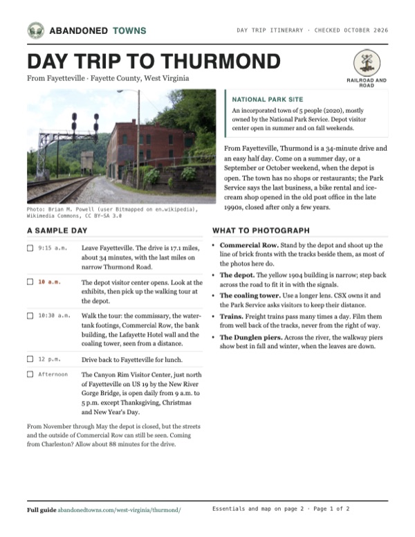
- Commercial Row. Stand by the depot and shoot up the line of brick fronts with the tracks beside them, as most of the photos here do.
- The depot. The yellow 1904 building is narrow; step back across the road to fit it in with the signals.
- The coaling tower. Use a longer lens. CSX owns it and the Park Service asks visitors to keep their distance.
- Trains. Freight trains pass many times a day. Film them from well back of the tracks, never from the right of way.
- The Dunglen piers. Across the river, the walkway piers show best in fall and winter, when the leaves are down.
Map & directions
Getting there
Fayetteville is the closest town, about 34 minutes away. From Charleston the drive runs down I-64/I-77 and across to Glen Jean. Both routes end on Thurmond Road, which the Park Service calls winding and narrow, and both finish on Highland Street, on the hillside above the tracks where the mapped town point is. The depot visitor center is on the way in, about 0.6 mile before the end (NPS GPS 37.95712, -81.07879), and the Park Service's walking tour starts there.


Base map: USGS The National Map (public domain). Routes: OSRM on © OpenStreetMap contributors data (ODbL), computed October 2026. Times assume dry roads.
- From North Court Street, follow WV 16 south out of Fayetteville.2.9 mi
- Turn right on Appalachian Drive, then left onto US 19.4.9 mi
- Turn left on Legends Highway (WV 16 / WV 61), then left on Glen Jean Lane and McKell Avenue in Glen Jean.2.3 mi
- Turn left on Thurmond Road (County Route 25) and follow it down into the gorge; it becomes CR 25/2 and passes the depot.6.7 mi
- Turn right on Hill Street, then right on Highland Street, where the mapped town point is.0.3 mi
- From downtown Charleston, take Lee Street East and Brooks Street (US 60) to the interstate.0.9 mi
- Follow I-64/I-77 south and take the exit for Okey L. Patteson Road.40.3 mi
- Turn left on Okey L. Patteson Road (WV 612).7.7 mi
- Turn right on Scarbro Road (CR 21/20) into Glen Jean, then left on McKell Avenue.2.3 mi
- Turn left on Thurmond Road (CR 25) and follow it down into the gorge; it becomes CR 25/2 and passes the depot.6.7 mi
- Turn right on Hill Street, then right on Highland Street.0.3 mi
Road and safety notes
- The Park Service's travel advisory says Thurmond Road is winding and narrow at times, and vehicles over 25 feet long and trailers are not recommended.
- The track through town is the active CSX main line, with many freight trains a day. Cross only at the designated crossing and don't walk on the tracks.
- The Rend Trail, the rail trail that leaves from the Thurmond side, is closed from both ends for rebuilding until about December 2027, the park reported in September 2026.
- Some buildings, including the old commissary, are privately owned, and the town still had 5 residents at the 2020 census. Stay off private property.
- Amtrak's Cardinal stops at Thurmond only as a flag stop for passengers with reservations, the park's directions page says.
- The routes are computed from OpenStreetMap and haven't been driven by us. We have no dated source on road surfaces.
Photos
Thurmond in photos
Visitor reports
Been to Thurmond?
Been there lately? Tell the next visitor what you found: whether you could get in, the state of the road and what's still standing. Photos are welcome. We read every report before it appears here.
Railroad and road
More railroad, road and fort ghost towns
The nearest, in other states.

 Guide
Moonville
39.31, -82.32Vinton County, Ohio
The last family left this Vinton County railroad hamlet in 1947. Its brick-lined tunnel survived, and the former rail corridor became the Moonville…
 Guide
Ellenton
33.22, -81.73Aiken County, South Carolina
A railroad and farming town of about 760 people, emptied in the early 1950s to build the Savannah River Plant. Its streets and curbs lie in the woods…
Nearby
Other sites near Thurmond
Straight-line distance from the townsite to other mapped sites in our West Virginia index.
- Erskine0.4 mi N · Fayette
- Concho0.5 mi NW · Fayette
- Dimmock0.7 mi E · Fayette
- Rush Run0.9 mi E · Fayette
- Stone Cliff2.0 mi SE · Fayette
- Beury2.2 mi E · Fayette
- Red Ash2.3 mi E · Fayette
- Fire Creek2.9 mi E · Fayette
Sources
Sources and credits
- ghosttowns.com, "Thurmond": fact sheet field (county).
- Wikipedia, "Thurmond, West Virginia", retrieved October 2026: coordinates and elevation, the 73 acres, incorporation, post office dates, census figures 1910–2020, access only by rail until 1921, the bank closures, W. D. Thurmond's alcohol ban, the late-1980s land purchases, the National Register listing, Matewan, Amtrak.
- National Park Service, "Thurmond", updated April 14, 2026: the 1873 land purchase, 1910 revenue, freight and 75,000 passengers, the decline, the town's government and reunion, the 1995 depot restoration, stabilization since 2003, the 2023 depot work, the visitor center season, the driving directions and the 25-foot travel advisory.
- National Park Service, "Thurmond Walking Tour", updated September 28, 2026: the tour's length and time, the active CSX main line, and the history of the depot, commissary and post office, water tanks, Mankin-Cox, Goodman-Kincaid and bank buildings, Lafayette Hotel, coaling tower and engine house.
- National Park Service, "The Dunglen Hotel", updated December 16, 2025: the 1901 hotel, Glen Jean town limits, the walkway piers, the July 1930 fire and arson acquittal, the site's present use.
- National Park Service, "Thurmond Depot", updated December 16, 2025: the boomtown summary and up to 95,000 passengers a year.
- National Park Service, "Operating Hours & Seasons", page updated October 1, 2024, read October 20, 2026: depot and Canyon Rim visitor center hours. "Directions", updated March 17, 2026: depot address and GPS, Amtrak flag stop. "Fees & Passes", read October 20, 2026 (lists the 2026 free-entrance days): no entrance fee. "Road and Trail Closures", updated September 24, 2026: the Rend Trail closure. "Superintendent's Compendium", updated July 6, 2026: drones prohibited without written approval.
- e-WV, "Thurmond" by Ken Sullivan, revised February 8, 2024: W. D. Thurmond as a strict Baptist, the Dunglen poker game, the 1986 filming of Matewan, the decline.
- Photos: Wikimedia Commons, credited below each one. Elevation: USGS 3D Elevation Program point query. Routes: OSRM on OpenStreetMap data, October 2026. Not field-checked.
Photo and map credits
- Commercial Row beside the tracks, with the coaling tower down the line, June 2005: Brian M. Powell (user Bitmapped on en.wikipedia), Wikimedia Commons, CC BY-SA 3.0
- The depot and the CR 25/2 bridge over the New River, June 2005: Brian M. Powell (user Bitmapped on en.wikipedia), Wikimedia Commons, CC BY-SA 3.0
- Commercial Row from across the tracks, November 1988: Jet Lowe, Wikimedia Commons, Public domain
- The concrete coaling tower, October 2026: George Neat, Wikimedia Commons, CC BY-SA 4.0
- Commercial Row and the coaling tower, December 2015: Bestbudbrian, Wikimedia Commons, CC BY-SA 4.0
- The 1904 depot, December 2015: Bestbudbrian, Wikimedia Commons, CC BY-SA 4.0
- A CSX freight passing the bank building, November 2009: jpmueller99 from Shenandoah Valley of VA, USA, Wikimedia Commons, CC BY 2.0
- Commercial Row along the tracks, with the coaling tower at the far end, December 2005: David Hafley, Wikimedia Commons, Public domain
- The steam locomotive Nickel Plate 765 rolling through town, October 1985: Bruce Fingerhood from Springfield, Oregon, US, Wikimedia Commons, CC BY 2.0
- Area base map, topo and aerial imagery: USGS The National Map (public domain).
- Historic maps: USGS Historical Topographic Map Collection (public domain): Raleigh 1891, 1:125,000; Beckley 1911, 1:48,000; Beckley 1929, 1:62,500; Thurmond 1969, 1:24,000.