 Abandoned

Overview
The other gateway to the Klondike

Dyea sits where the Taiya River runs out into Taiya Inlet, at the top of Lynn Canal and about 10 miles by road from Skagway. For centuries the valley belonged to the Chilkat Tlingit, who fished here and kept the Chilkoot Pass above it as their private trade route to the interior. In the mid-1880s John Healy and Edgar Wilson opened a trading post at the river mouth to supply the few prospectors crossing into the Yukon.
Then came the Klondike. When news of the strike reached the newspapers in July 1897, thousands of stampeders landed at Dyea and started up the Chilkoot Trail. By that winter Dyea was a town of more than 150 businesses, with two wharves, two newspapers, two telephone companies and a sawmill. On April 3, 1898, an avalanche north of Sheep Camp killed more than 70 people on the trail. Wooden markers dated that day still stand in the Slide Cemetery.
Dyea's harbor was shallow and Skagway's was deep, and in May 1898 the White Pass and Yukon Route railroad began building from Skagway over the other pass. The stampede moved with it. The Chilkoot tramways were sold and pulled down, about 250 people were left in 1900, the post office closed in June 1902, and by 1903 fewer than six people lived on the townsite. The National Park Service bought much of it in 1978. Today it is woods and meadow on the flats, with foundations, a relocated log cabin, the ruins of the wharf and the cemeteries.
Timeline
From trading post to park

- The Taiya valley is a seasonal fishing camp and the start of the Chilkat Tlingit trade route over the Chilkoot Pass. The Tlingit do not let outsiders use the pass.
- Commander L. A. Beardsley of the U.S. Navy reaches an agreement with the Chilkat Tlingit. In May 1880 Tlingit guides take the first party of prospectors over.
- John J. Healy and his brother-in-law Edgar Wilson open a trading post at the head of Taiya Inlet. Wikipedia dates the post, and the first use of the name Dyea there, to 1886.
- News of the Klondike strike reaches the newspapers and stampeders pour ashore on the Dyea flats, bound for the Chilkoot Trail.
- Downtown Dyea is about five blocks wide and eight long, with more than 150 businesses, two wharves including the Long Wharf, two newspapers, two telephone companies and a sawmill.
- The Palm Sunday avalanche north of Sheep Camp on the Chilkoot Trail kills more than 70 people. The Slide Cemetery at Dyea holds graves dated to that day.
- Work starts on the White Pass and Yukon Route railroad from Skagway. Most new stampeders now land at Skagway instead.
- The White Pass company buys the Chilkoot aerial tramways in summer 1899 and removes most of them in early 1900. A forest fire in late July 1899 burns the U.S. Army camp.
- The NPS puts the population at about 250 in March 1900. The 1900 census, the only one to list Dyea, counts 261 (Wikipedia). An informal count in spring 1901 finds 71 with any interest in the town.
- The post office closes. By 1903 fewer than six people live on the old townsite.
- Homesteaders including Joseph Waughn, William Matthews, Ernest Richter, Mary Hart, Emil Klatt and William Maksym claim land. All give up or sell to Harriet Pullen, a Skagway hotel owner.
- The National Park Service buys much of the old townsite. Today the park manages it as part of Klondike Gold Rush National Historical Park, and the townsite is recognized as a National Historic Landmark (Chilkoot Trail and Dyea Site).
- Floods on the Taiya River wash out parts of the townsite trails. The park closes those sections indefinitely.
- The park replaces culverts on Dyea Flats Road near the Slide Cemetery, with single-lane traffic and two full closures planned between October 15 and November 23.
What's left
Woods, flats and the Slide Cemetery


Little of the boomtown stands. The NPS calls the townsite a major archaeological site with many ruins that are hard to identify, and Wikipedia lists foundations surrounded by scraps of lumber and metal, three cemeteries and the ruins of the wharf. The Slide Cemetery holds rows of wooden markers, many dated April 3, 1898, the day of the avalanche. NPS photos from 2017 show the relocated McDermott Cabin, a log cabin with a steep roof, standing in a mowed clearing, and the open tidal flats. The park says the Taiya River undercuts the bank at the north end of the townsite trails, and that floods since 2018 have destroyed parts of the trails.
The 1991 USGS sheet in the historic maps below marks Dyea twice: once at the old townsite by the river's West Branch and once up the valley, with the Slide Cemetery between them and the campground across the Taiya. Today's topo traces Main Street, West Street and Scow Street as trails through the woods.
- Foundations and scattered lumber and metal
- Wharf ruins
- Relocated McDermott Cabin
- Slide Cemetery (1898)
- Two other cemeteries
- Tidal flats


Historic maps
Dyea on USGS maps, 1952–1991
Crops from the USGS Historical Topographic Map Collection, centered on the townsite. Each sheet shows what surveyors mapped that year; compare them with today's topo and aerial on this page.

Day trip
Plan a day trip to Dyea from Skagway
Take it with you
Day trip itinerary
The essentials, the sample day with boxes to tick, what to photograph and the coordinates, on two printable pages. Handy where there's no signal.
Download the PDF (677 KB)Dyea is about 25 minutes from Skagway on Dyea Road, and the townsite walk, the Slide Cemetery and the flats fill a morning. There is nothing to buy at Dyea, so bring food and water. Until November 23, 2026, culvert work on Dyea Flats Road brings flaggers and two full closures; on closure days, park at the Chilkoot Trailhead and walk in.
A sample day
- Leave Skagway north on State Street and the Klondike Highway, then turn onto Dyea Road. During a closure, stop at the Chilkoot Trailhead.
- Park at the townsite lot and walk the trails west of the Taiya River, reading the panels. Stay out of the closed sections.
- Cross the footbridge into the Slide Cemetery, where many markers carry the date of the 1898 avalanche.
- Eat a packed lunch, then walk out onto the tidal flats.
- Drive back to Skagway, inside the four-hour parking limit.
No car? The park runs no transport to Dyea, so you need a private tour or shuttle from Skagway. The NPS says maps of the townsite trails are at the visitor center at 2nd and Broadway in Skagway.
What to photograph and film
- The Slide Cemetery. Rows of wooden grave markers. The cemetery belongs to the Municipality of Skagway, not the park; be respectful.
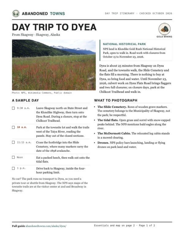
- The tidal flats. Open grass and sorrel with snow-capped peaks behind. The NPS mentions bald eagles along the river.
- The McDermott Cabin. The relocated log cabin stands in a mowed clearing.
- Drones. NPS policy bars launching, landing or flying drones on park land and water.
Map & directions
Getting there
Skagway is the nearest town, about 25 minutes away. Dyea Road leaves the Klondike Highway at the north end of town and runs around the head of Taiya Inlet to the townsite. The second route below comes from Whitehorse, Yukon, down the Klondike Highway. Between October 24 and November 17, 2026, two closures on Dyea Flats Road may mean parking at the Chilkoot Trailhead and walking the rest.


Base map: USGS The National Map (public domain). Routes: OSRM on © OpenStreetMap contributors data (ODbL), computed October 2026. Times assume dry roads.
- From downtown Skagway, follow State Street (AK 98) north, continuing as 23rd Avenue and the Klondike Highway.1.7 mi
- Turn left on Dyea Road.4.1 mi
- Keep right at the fork, staying on Dyea Road.3.1 mi
- Bear left on Dyea Historic Townsite Road to the townsite.1.0 mi
- From downtown Whitehorse, take Fourth Avenue and Robert Service Way to the Alaska Highway.3.1 mi
- Turn left on the Alaska Highway (Yukon 1 and 2).9.2 mi
- Turn right on the Klondike Highway (Yukon 2) and follow it south, crossing the Canada–US border, to the Dyea Road turnoff above Skagway.95.3 mi
- Turn right on Dyea Road.4.1 mi
- Keep right at the fork, staying on Dyea Road.3.1 mi
- Bear left on Dyea Historic Townsite Road to the townsite.1.0 mi
Road and safety notes
- The NPS directions page, last updated August 6, 2024, says Dyea Road "is primarily dirt, but graded each summer" and suggests asking at the visitor center at 2nd and Broadway in Skagway for current conditions. We have no newer report on the surface.
- Road work on Dyea Flats Road runs from October 15 to November 23, 2026, with two full closures to through traffic between October 24 and November 17. The park posts updates on its alerts page and through KHNS radio; questions go to [email protected].
- The same 2024 page limits parking at the townsite lots to four hours and sends overnight Chilkoot hikers to the Dyea Campground lot.
- Some townsite trail sections are closed indefinitely after Taiya River flooding. Obey the closures.
- Wikipedia notes that visitors can usually spot brown bears, black bears and eagles, and that brown bears feed in the Dyea inlets during the July–August salmon spawning season.
- The park does not run transportation to Dyea. Without a car, you need a private tour or shuttle from Skagway.
- The routes are computed from OpenStreetMap and haven't been driven by us.
Photos
Dyea in photos
Visitor reports
Been to Dyea?
Been there lately? Tell the next visitor what you found: whether you could get in, the state of the road and what's still standing. Photos are welcome. We read every report before it appears here.
Gold mining
More gold mining ghost towns
The nearest in Alaska.

 Guide
Chicken
64.07, -141.94Southeast Fairbanks, Alaska
A gold camp on Chicken Creek that has hung on since the 1890s. Twelve people lived here in 2020. In summer, three small businesses sell fuel, food…
 Guide
Independence Mine
61.79, -149.28Matanuska-Susitna, Alaska
A gold-mining camp high in the Talkeetna Mountains, where more than 200 men worked in 1941. The bunkhouses, mess hall and manager's house still stand…
Nearby
Other sites near Dyea
Straight-line distance from the townsite to other mapped sites in our Alaska index.
Sources
Sources and credits
- Wikipedia, "Dyea, Alaska", retrieved October 2026: coordinates, the 1886 name, the shallow harbor, the 1900 census, the National Historic Landmark, remains (foundations, three cemeteries, wharf ruins) and bears.
- National Park Service, "Dyea" (Klondike Gold Rush NHP history page, last updated July 9, 2025): Tlingit use, the Beardsley agreement and 1880 crossing, Healy and Wilson, the size of the town in 1897–98, the avalanche, the railroad, the tramways, the 1899 fire, the 1900, 1901 and 1903 counts, the June 1902 post office closure, the homesteaders, the 1978 purchase and the remains.
- National Park Service, "Dyea Flats Road construction to cause temporary closures, delays", October 7, 2026: the culvert work, the schedule of lane restrictions and closures, parking at the Chilkoot Trailhead and walking in, and the contacts.
- National Park Service, Klondike Gold Rush alerts and conditions, read October 20, 2026: the indefinite closure of townsite trail sections after Taiya River floods since 2018.
- National Park Service, "Directions and Transportation", last updated August 6, 2024: distances from Skagway, no park transportation, the Dyea Road surface, the four-hour parking limit and the visitor center.
- ghosttowns.com, "Dyea": fact sheet fields (climate, best time).
- National Park Service, "Historic Dyea Townsite" (things to do, last updated October 31, 2020): the 1 to 2 hour self-guided walk, hard-surface trails for all abilities, panels, eagles, maps at the visitor center, year-round season, leashed pets in bear country.
- National Park Service, "Fees & Passes" (last updated May 29, 2025): no entrance fee. "Campgrounds" (April 22, 2024) and "Frequently Asked Questions" (July 25, 2024): Dyea Campground toilets, winterizing, no water or groceries. "Gold Rush Cemeteries" (July 25, 2024): the footbridge to the municipal Slide Cemetery. All read October 21, 2026, for the day trip.
- National Park Service, "Unmanned Aircraft in the National Parks" (last updated May 22, 2025): the drone rule.
- Photos: Wikimedia Commons, credited below each one. Elevation: USGS 3D Elevation Program point query. Routes: OSRM on OpenStreetMap data, October 2026. Not field-checked.
Photo and map credits
- Grass and sorrel on the Dyea tidal flats, June 2017: NPS, Wikimedia Commons, Public domain
- A driftwood stump on the Dyea flats, May 2014: Anthony DeLorenzo from Whitehorse, Yukon, Canada, Wikimedia Commons, CC BY 2.0
- The Taiya River and its flats at the old townsite, May 2005: Mike Colvin from Manchester, UK, Wikimedia Commons, CC BY 2.0
- The Taiya River estuary from Dyea Road, October 2005: Luigi Zanasi, Wikimedia Commons, CC BY-SA 2.0 ca
- W. Carl's marker in the Slide Cemetery: died April 3, 1898: NPS, Wikimedia Commons, Public domain
- Dyea from the summit of Dyea Mountain, looking down Taiya Inlet toward Lynn Canal, about 1899: Pillsbury, Arthur C. (Arthur Clarence), Wikimedia Commons, Public domain
- The Slide Cemetery, June 2016: NPS, Wikimedia Commons, Public domain
- The relocated McDermott Cabin, June 2017: NPS, Wikimedia Commons, Public domain
- The steamer Queen unloading stampeders onto a scow, 1897: Frank La Roche, Wikimedia Commons, Public domain
- Main Street, about 1898: Eric A. Hegg, Wikimedia Commons, Public domain
- Area base map, topo and aerial imagery: USGS The National Map (public domain).
- Historic maps: USGS Historical Topographic Map Collection (public domain): Skagway 1952, 1:250,000; Skagway 1961, 1:250,000; Skagway C-1 SW 1991, 1:25,000.