 Abandoned
Overview
The town one family owned

Cleator sits at the foot of the Bradshaw Mountains near Turkey Creek, on the dirt road from I-17 to Crown King. Placer miners worked the area from 1864, but the town really began with the railroad. Lev Nellis opened a store and saloon in 1901, and in November 1902 the Bradshaw Mountain Railroad reached Turkey Creek on its way up to the Crown King mines.
James P. Cleator, a sailor from the Isle of Man who had prospected in California, joined Nellis as a partner in 1905. Ten years later they split their holdings. Cleator traded his share of their ranch and $2,500 for the whole town, and in 1925 he renamed the post office after himself. Mining faded in the 1920s and the railroad was pulled out by 1932. In 1949 Cleator tried to sell the town, then home to about 60 people, and found no buyer.
His son Tom owned it from 1959 until he died in 1996 and kept the little bar open most of those years. Eight people lived in Cleator in 2020, when the family listed it for $1.25 million. It sold in January 2022 for $956,000 to a buyer who, the listing agent said, planned to keep it as it is. Today it is a private town with a few residents and a bar that serves the off-road and weekend traffic heading for Crown King.
Timeline
From Turkey Creek to Cleator

- Gold turns up about two miles from Turkey Creek, and placer mining begins in the Turkey Creek Mining District.
- A Turkey Creek post office opens. It closes within a few months.
- Lev P. Nellis opens a store and saloon, betting that the railroad will come.
- The Bradshaw Mountain Railroad reaches Turkey Creek on its way to Crown King.
- The post office reopens.
- James P. Cleator, a Manx sailor turned prospector, becomes Nellis's partner in the town and a ranch.
- The partners split. Cleator trades his share of the ranch and $2,500 for the whole town.
- Cleator renames the post office after himself, and the town takes the name.
- Mining fades and people leave. The railroad is gone by 1932.
- James Cleator puts the town up for sale. About 60 people live there. Nobody buys it.
- The post office closes for good.
- After James dies, his son Tom owns the town, lives there and keeps the bar open until his death in 1996.
- Eight people live in Cleator. The family lists the town for $1.25 million.
- The town sells for $956,000. The buyer plans to keep it as it is.
- The bar changes hands, according to its website.
What's here
A bar, a store and a yacht club with no water

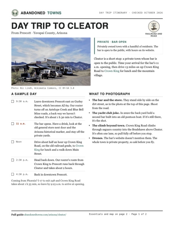
The town covers about 40 acres and has about 20 buildings. The one most visitors stop for is the Cleator Bar & Yacht Club, next to the old general store, whose sign carried James P. Cleator's name in 2012. The yacht club is a joke, since there is no water anywhere near town. In 2020 the bar's back yard held a second bar built into an old pontoon boat. An Arizona historical marker stands in town.
Most other buildings are homes. In 2020 every resident rented from the family that owned the town. We haven't found out who owns it now or confirmed the age of the old schoolhouse that an undated listing names among the remains.
- Cleator Bar & Yacht Club
- James P. Cleator general store
- Old schoolhouse (date unconfirmed)
- Houses and cabins, most lived in
- Arizona historical marker
- Old railroad grade (now the road)
The historic maps trace the change. The 1887 sheet shows no town here, only Antelope Creek, Mayer, Bueno and Alexander. The 1903 sheet marks Turkey Creek, Crazy Basin and a scatter of mines and wagon roads, with Cordes to the northeast, but no town name. By 1947 Cleator is on the map with the St. Johns, Gray Goose, French Lilly, Golden Belt and Golden Turkey mines around it and a margin note pointing to Crown King, 12 miles away. The 1974 sheet shows the water tanks and the cluster of buildings at the crossroads.


Historic maps
Cleator on USGS maps, 1887–1981
Crops from the USGS Historical Topographic Map Collection, centered on the townsite. Each sheet shows what surveyors mapped that year; compare them with today's topo and aerial on this page.

Day trip
Plan a day trip to Cleator from Prescott
Take it with you
Day trip itinerary
The essentials, the sample day with boxes to tick, what to photograph and the coordinates, on two printable pages. Handy where there's no signal.
Download the PDF (478 KB)Cleator is a short stop: a private town whose bar is open to the public. Time your arrival for the bar's 11 a.m. opening, then drive 13 miles on up Crown King Road to Crown King for lunch and the mountain village.
A sample day
- Leave downtown Prescott east on Gurley Street, which becomes AZ 69. Our router turns off on Antelope Creek and Blue Bell Mine roads, a back way we haven't checked. It's about 1 h 30 min to Cleator.
- The bar opens. Have a drink, look at the old general store next door and the Arizona historical marker, and stay off the private yards.
- Drive about half an hour up Crown King Road, on the old railroad grade, to Crown King for lunch and a walk down Main Street.
- Head back down. Our router's route from Crown King to Prescott runs back through Cleator and takes about 2 hours.
- Back in downtown Prescott.
Coming from Phoenix? I-17 to exit 248 and Crown King Road takes about 1 h 35 min, so leave by 9:25 a.m. to arrive at opening.
What to photograph and film
- The bar and the store. They stand side by side on the dirt street, as in the photo at the top of this page. Shoot from the road.
- The yacht club joke. In 2020 the back yard held a second bar built into an old pontoon boat. If it's still there, it's the shot.
- The climb beyond town. Crown King Road climbs through saguaro country into the Bradshaws above Cleator. It's often one lane, so pull fully off before you stop.
- Drones. The bar's website doesn't mention them. The whole town is private property, so ask before you fly.
Map & directions
Getting there
Cleator is on Crown King Road, the graded dirt road from I-17 to Crown King. From Phoenix, leave I-17 at the Bumble Bee exit. Prescott is the closest city. The Prescott route below was computed by OSRM over back roads near Mayer that we haven't checked.


Base map: USGS The National Map (public domain). Routes: OSRM on © OpenStreetMap contributors data (ODbL), computed October 2026. Times assume dry roads.
- From downtown Prescott, head east on Gurley Street. It becomes AZ 69. Follow AZ 69 southeast.27.7 mi
- Turn left onto Antelope Creek Road, then right onto Blue Bell Mine Road, a back road we haven't checked.7.5 mi
- Keep right on Blue Bell Mine Road into Cleator.2.0 mi
- From downtown Phoenix, take 3rd Avenue north to I-10 and follow exit 143A to I-17 north.3.2 mi
- Follow I-17 north and take exit 248, the Bumble Bee exit.47.2 mi
- Turn left onto Bumble Bee Road. It runs north through Bumble Bee as graded dirt, under the names Crown King Road and Bumble Bee Road.10.4 mi
- Continue on Crown King Road to Cleator.4.5 mi
Road and safety notes
- Crown King Road is graded dirt from I-17. An undated listing rates the drive 2WD, and a Crown King business calls the road fine for passenger cars in normal conditions, with 4WD sometimes needed in snow or monsoon storms.
- Heavy rain can close it. In July 2012 a mudslide shut Crown King Road between Cleator and the Poland Creek bridge.
- There is no auto repair between I-17 and Crown King, and cell service is unreliable. Carry water.
- Cleator is private property. Visit the bar and stay off the yards and out of the houses.
- Expect off-road vehicles, cyclists and cattle on the road, especially on weekends.
Photos
Cleator in photos
Visitor reports
Been to Cleator?
Been there lately? Tell the next visitor what you found: whether you could get in, the state of the road and what's still standing. Photos are welcome. We read every report before it appears here.
Railroad and road
More railroad, road and fort ghost towns
The nearest in Arizona.

 Guide
Cordes
34.30, -112.17Yavapai County, Arizona
An adobe stage stop on the old road between Prescott and Phoenix that became a store, post office and sheep station. The highway left it behind in…
 Guide
Bumble Bee
34.20, -112.15Yavapai County, Arizona
A stage stop on the old Phoenix–Prescott road, rebuilt in the 1930s and dressed up as a ghost town around 1970. The fake town is gone; a few real…
Nearby
Other sites near Cleator
Straight-line distance from the townsite to other mapped sites in our Arizona index.
- Cordes4.1 mi NE · Yavapai
- Bumble Bee7.1 mi SE · Yavapai
- Crown King7.9 mi SW · Yavapai
- Hooper8.6 mi W · Yavapai
- Bradshaw City9.0 mi SW · Yavapai
- Goodwin9.9 mi NW · Yavapai
- Big Bug12.1 mi N · Yavapai
- Fort Misery12.2 mi SW · Yavapai
Sources
Sources and credits
- ghosttowns.com, "Cleator": fact sheet fields (roads, legal description, climate, best time, remains, post office dates).
- Wikipedia, "Cleator, Arizona", retrieved October 2026: Turkey Creek history, the Nellis and Cleator partnership, renaming, 1949 sale attempt, family ownership, 2020 population and listing, historical marker, coordinates (GNIS).
- Wikipedia, "Bradshaw Mountain Railroad": the line reached Turkey Creek on November 30, 1902.
- Mental Floss, July 23, 2020: the $1.25 million listing, 40 acres, 20 buildings, eight renting residents, the yacht club joke and pontoon-boat bar.
- KOLD News 13, February 2, 2022: sale for $956,000, what was included and the buyer's plans.
- Cleator Bar & Yacht Club and its history page, as of October 2026: hours, 2025 change of owners, no mention of food, restrooms or drones.
- Crown King Saloon & Eatery, as of October 2026: food served in Crown King.
- crownking.com, "Directions" (a Crown King lodging business, 2023): exit 248, road surface and vehicle advice, no auto services, cell reception. KTAR, July 16, 2012: mudslide closure near Cleator.
- Elevation: USGS 3D Elevation Program point query. Routes: OSRM on OpenStreetMap data, October 2026; the Prescott route is not field-checked. Status checked against the sources above on October 19, 2026.
Photo and map credits
- The bar and the general store, 2012: Nic Lindh, Wikimedia Commons, CC BY-SA 3.0
- An old wooden building in town, 2015: Mimi Cummins from Canada, Wikimedia Commons, CC BY 2.0
- The hills on the road from Cleator to Crown King, 2015: Mimi Cummins from Canada, Wikimedia Commons, CC BY 2.0
- Cleator at its crossroads among the mines, USGS Mayer sheet, 1947: U.S. Geological Survey, USGS catalog, Public domain
- Area base map, topo and aerial imagery: USGS The National Map (public domain).
- Historic maps: USGS Historical Topographic Map Collection (public domain): Prescott 1887, 1:250,000; Bradshaw Mountains 1903, 1:125,000; Mayer 1947, 1:62,500; Cleator 1974, 1:24,000; Bradshaw Mts 1981, 1:100,000.