 Abandoned

Overview
The silver camp that became a Route 66 stop

Hackberry sits on old Route 66 about 29 road miles northeast of Kingman, at the west end of Truxton Canyon. It started in 1874 as a silver camp on the east side of the Peacock Mountains, named for a big hackberry tree at a spring beside the mine. When the Atlantic & Pacific Railroad built through in 1882 and 1883, the settlement moved about four miles to the tracks and the station took the mine's name.
The Hackberry mine produced almost $3 million in silver. By 1919 the ore was running out, the owners were in court against each other, and the mine closed. The railroad town carried on as a cattle-shipping point, at one time third in Arizona by volume. Route 66 arrived in 1926, and garages and a grocery served travelers until 1978, when I-40 opened on a more direct line about 16 miles to the south. The Northside Grocery and its Conoco station closed that year.
In 1992 Route 66 artist Bob Waldmire reopened the old grocery as a souvenir shop and information stop. Later owners kept its weathered look and filled the yard with old cars, gas pumps and signs. The store is still open, and it's the reason most people stop. The 2020 census counted 103 people in the Hackberry area.
Timeline
Mine, railroad, highway, store

- Prospectors set up a silver camp on the east side of the Peacock Mountains. The mine is named for a big hackberry tree at a spring beside it.
- Prospector Jim Music helps develop the Hackberry silver mine.
- A post office opens, according to one Route 66 history.
- The Atlantic & Pacific Railroad builds through. The settlement moves about four miles to the tracks, and the station takes the mine's name.
- Photographer C. C. Pierce makes a series of portraits of Hualapai families at Hackberry.
- A two-room, mission-style school is built.
- With the ore running out and the owners suing each other, the mine closes. It had produced almost $3 million in silver.
- Route 66 comes through town on the line of the National Old Trails Highway.
- The Northside Grocery opens with a Conoco station. Most sources say 1934; one says 1932.
- Road crews work on the unpaved stretch of US 66 between Kingman and Peach Springs through Hackberry.
- A Route 66 guidebook counts 94 residents, three gas stations and a lunchroom.
- I-40 opens on a more direct line about 16 miles south. The Northside Grocery closes.
- Route 66 artist Bob Waldmire reopens the old grocery as a souvenir shop and information post.
- The school closes, and students ride the bus to Kingman.
- Waldmire sells the store to John and Kerry Pritchard.
- The Pritchards retire, and Amy Franklin takes over the store.
- The census counts 103 people in the Hackberry area.
- A July 2025 news feature describes the store in business, and April 2026 photos show it unchanged.
Route 66
The Hackberry General Store


The store began as the Northside Grocery, built on the highway north of the railroad with a Conoco station out front. Most sources date it to 1934; a 2025 KFDA feature says 1932. It closed in 1978 when I-40 took the traffic away.
Bob Waldmire, the artist and mapmaker whose 1972 Volkswagen bus inspired a character in the 2006 film Cars, reopened it in 1992 as a souvenir shop and Route 66 information post. He sold it to John and Kerry Pritchard in 1998. The Pritchards retired in 2016, and Amy Franklin took over, according to theroute-66.com.
The pumps out front are for show. No gas is sold here.
Inside, the store sells license plates, shirts, replica signs and cold drinks. Outside there's shade under the old fueling canopy, a yard of old cars, trucks and parts, and a big collection of metal signs. One sign warns of 300 miles of desert ahead. KFDA suggests taking it with a grain of salt today.
What's there
A railroad town on old 66

The general store stands on Route 66 about half a mile northeast of the townsite point. The rest of Hackberry is a scatter of houses west of Truxton Wash and the railroad. An undated listing describes a few old buildings and a few residents. Legends of America dates the town's mission-style school to 1917 and its closing to 1994.
The historic USGS sheets further down tell the story of the move. The 1886 sheet marks Hackberry on the Atlantic and Pacific line and “Old Hackberry” at the foot of the Peacock Mountains to the southwest. The 1948 and 1954 sheets show US 66 running beside the railroad through town, with ranches around it and the Hualapai Indian Reservation to the east. The 1968 Hackberry sheet marks a water tank and wells and notes Kingman 28 miles away. The 1984 sheet names the Hackberry, North Hackberry and Sunshine mines in the hills to the southwest.
- Hackberry General Store (1930s)
- Vintage gas pumps and signs
- Old cars and trucks
- Railroad
- Houses of the townsite
- Hackberry mine area in the Peacock Mountains


Historic maps
Hackberry on USGS maps, 1886–1984
Crops from the USGS Historical Topographic Map Collection, centered on the townsite. Each sheet shows what surveyors mapped that year; compare them with today's topo and aerial on this page.

Day trip
Plan a day trip to Hackberry from Kingman
Take it with you
Day trip itinerary
The essentials, the sample day with boxes to tick, what to photograph and the coordinates, on two printable pages. Handy where there's no signal.
Download the PDF (537 KB)Hackberry is 40 minutes northeast of Kingman on old Route 66, an easy half day. The general store is the reason to go, a souvenir shop with a yard full of old cars, pumps and signs. It's the only business in town and has no fuel for sale, so pair it with Kingman's Route 66 museum and a diner lunch.
A sample day
- Start at the Arizona Route 66 Museum on Andy Devine Avenue in Kingman. It opens daily at 8 a.m. Admission is $10 for adults and $6 for seniors 60 and over. Children 12 and under, veterans and first responders get in free.
- Drive northeast on Route 66, about 40 minutes.
- Browse the Hackberry General Store, then photograph the cars, pumps and signs out front.
- Head back to Kingman the way you came.
- Lunch at Mr. D'z Route 66 Diner, 105 E. Andy Devine Ave, open daily from 7 a.m. to 8 p.m.
- The Mohave Museum of History and Arts, at 400 W. Beale St., is open Tuesday to Saturday, 9 a.m. to 4 p.m. One ticket covers both museums.
Coming from Flagstaff? Take I-40 west to Seligman and follow Route 66 west through Peach Springs, Truxton and Valentine. Kingman is another 40 minutes past Hackberry.
What to photograph and film
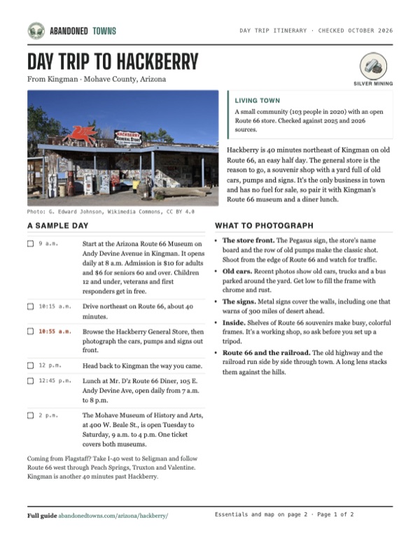
- The store front. The Pegasus sign, the store's name board and the row of old pumps make the classic shot. Shoot from the edge of Route 66 and watch for traffic.
- Old cars. Recent photos show old cars, trucks and a bus parked around the yard. Get low to fill the frame with chrome and rust.
- The signs. Metal signs cover the walls, including one that warns of 300 miles of desert ahead.
- Inside. Shelves of Route 66 souvenirs make busy, colorful frames. It's a working shop, so ask before you set up a tripod.
- Route 66 and the railroad. The old highway and the railroad run side by side through town. A long lens stacks them against the hills.
Map & directions
Getting there
Hackberry is on Historic Route 66, now State Route 66, between Kingman and Seligman. From Kingman it's a straight run northeast of about 40 minutes. From Flagstaff, the route takes I-40 west to Seligman and then follows old Route 66 west through Peach Springs, Truxton and Valentine. The routes end at the townsite. The general store is on Route 66 itself, about half a mile northeast.


Base map: USGS The National Map (public domain). Routes: OSRM on © OpenStreetMap contributors data (ODbL), computed October 2026. Times assume dry roads.
- From downtown Kingman, take East Beale Street to the I-40/US 93 on-ramp and follow I-40 east.5 mi
- Exit and turn left on East Andy Devine Avenue (AZ 66, Historic Route 66). It becomes the Hualapai Veterans Highway.23.4 mi
- Turn right on Old Trails Highway, continue on County Route 366 and bear left onto North Main Street.1.1 mi
- From downtown Flagstaff, follow the I-40 business route (Santa Fe Avenue and Milton Road) to I-40.5 mi
- Take I-40 west and leave on the I-40 business loop at Seligman.71.1 mi
- At the end of the road, turn right on Historic Route 66 (Hualapai Veterans Highway) and follow it west through Peach Springs, Truxton and Valentine.59.3 mi
- Turn left on Old Trails Highway (County Route 366) and bear left onto North Main Street.1.1 mi
Road and safety notes
- Route 66 between Kingman and Seligman is a paved state highway. An undated listing rates the trip 2WD.
- There's no fuel in Hackberry. The store's pumps are for display. Fill up in Kingman.
- The store is the only business in town, and we didn't find posted hours. Check before a long detour.
- Most of Hackberry is private homes. Stay on public roads and the store grounds.
- Summer heat is severe. Fall through spring is the best time to go.
Photos
Hackberry in photos
Visitor reports
Been to Hackberry?
Been there lately? Tell the next visitor what you found: whether you could get in, the state of the road and what's still standing. Photos are welcome. We read every report before it appears here.
Silver mining
More silver mining ghost towns
The nearest in Arizona.
 Guide
Cerbat
35.30, -114.14Mohave County, Arizona
An 1870s silver-country camp that was briefly the Mohave County seat. The record is thin, and we haven't verified access, so this page shows its gaps.
 Guide
Chloride
35.41, -114.20Mohave County, Arizona
A silver camp from the 1860s that never quite emptied. About 230 people still live among its old buildings, yard art and painted boulders, and its…
Nearby
Other sites near Hackberry
Straight-line distance from the townsite to other mapped sites in our Arizona index.
- Mineral Park mine23.4 mi W · Mohave
- Cerbat23.7 mi W · Mohave
- Mineral Park24.0 mi W · Mohave
- Chloride26.6 mi W · Mohave
- Cyclopic40.8 mi NW · Mohave
- Cedar41.0 mi S · Mohave
- Goldroad43.1 mi SW · Mohave
- Oatman44.0 mi SW · Mohave
Sources
Sources and credits
- ghosttowns.com, "Hackberry": fact sheet fields (roads, legal description, climate, best time, remains).
- Wikipedia, "Hackberry, Arizona", retrieved October 2026: naming (citing Arizona Place Names), Jim Music, the 1919 closure, Route 66, the Northside Grocery, Waldmire and the Pritchards, 2020 census.
- Wikipedia, "U.S. Route 66 in Arizona": 1934 road work through Hackberry, the 1978 I-40 bypasses, State Route 66 and the towns along it.
- Legends of America, "Hackberry, Arizona – A Silver Mining Haven", updated October 2026: the 1874 camp, silver output, the railroad move, cattle shipping, the school, the store and its pumps.
- theroute-66.com, "Hackberry", updated July 2025: the 1878 post office, the 1946 guidebook count, the store's owners since 2016, Waldmire's bus.
- KFDA, "Hackberry Store" (July 1, 2025): the store in operation, what it sells including cold drinks, shade under the old fueling canopy, the 1932 opening date, the desert sign.
- Mohave County Historical Society, "Arizona Route 66 Museum", "Mohave Museum" and admission, as of October 2026: hours, addresses and the shared ticket.
- Explore Kingman, "Discover Kingman Route 66" (Kingman Office of Tourism, posted February 2025, checked October 2026): Mr. D'z Route 66 Diner, its address and hours.
- Store website: the domain hackberrygeneralstore.com showed only a "coming soon" placeholder in October 2026, so the page lists no official site.
- Historic Route 66 Association of Arizona, "Hackberry General Store": current listing, the 1934 opening and the 1992 reopening.
- Coordinates: USGS Geographic Names Information System, populated place "Hackberry", via The National Map. Wikipedia's point lies about a mile southwest.
- Commons file records for the April 2026 photos (store address) and the C. C. Pierce portraits (about 1900). Elevation: USGS 3D Elevation Program point query. Routes: OSRM on OpenStreetMap data, October 2026. Status checked against the sources above on October 19, 2026.
Photo and map credits
- The Hackberry General Store, April 2026: G. Edward Johnson, Wikimedia Commons, CC BY 4.0
- Pumps, picnic tables and a cat out front, April 2026: G. Edward Johnson, Wikimedia Commons, CC BY 4.0
- Mobil signs and old pumps at the store: Don Graham from Redlands, CA, Wikimedia Commons, CC BY-SA 2.0
- A vintage Corvette at the store, July 2011: Frank Kovalchek from Anchorage, Alaska, USA, Wikimedia Commons, CC BY 2.0
- The “300 miles desert ahead” sign: Marcin Wichary from San Francisco, U.S.A., Wikimedia Commons, CC BY 2.0
- The store front along Route 66, 2016: Mobilus In Mobili, Wikimedia Commons, CC BY-SA 2.0
- A windmill in Hackberry, 2008: Marcin Wichary from San Francisco, U.S.A., Wikimedia Commons, CC BY 2.0
- Two Hualapai (Walapai) horsemen at Hackberry, about 1900: Pierce, C.C. (Charles C.), 1861-1946, Wikimedia Commons, Public domain
- A Hualapai woman and two children camped outside their home, about 1900: Pierce, C.C. (Charles C.), 1861-1946, Wikimedia Commons, Public domain
- An old bus in the yard near the store, April 2026: G. Edward Johnson, Wikimedia Commons, CC BY 4.0
- A rusting station wagon beside the store, April 2026: G. Edward Johnson, Wikimedia Commons, CC BY 4.0
- Old cars along Route 66 at Hackberry, 2016: lewblank from Madison, WI, United States, Wikimedia Commons, CC BY-SA 2.0
- Area base map, topo and aerial imagery: USGS The National Map (public domain).
- Historic maps: USGS Historical Topographic Map Collection (public domain): Diamond Creek 1886, 1:250,000; Williams 1948, 1:250,000; Williams 1954, 1:250,000; Hackberry 1968, 1:24,000; Valentine 1984, 1:100,000.