 Abandoned

Overview
Gold, then the highway, then the burros

Oatman sits at about 2,700 feet in the Black Mountains, on the old Route 66 grade between Kingman and the Colorado River. It began around 1904 as Vivian, a tent camp for the Vivian Mining Company, and took the name Oatman in 1909. The usual story says the name honors Olive Oatman, a girl captured in 1851 after her family was killed on the trail west, who lived among the Mohave until 1856. A 1921 USGS survey photo also labels an Olla Oatman mine shaft at the edge of town.
Gold built the place. The Tom Reed mine hit a big ore body in 1908, and a 1915 strike on the United Eastern property set off a boom. Accounts of the peak population run from 3,500 to 10,000. One count puts the district's gold at about $36 million by 1930; another gives $40 million by 1941. Fire burned much of the town in 1921, United Eastern closed in 1924, and a wartime order shut the last mines in 1941.
Route 66 kept Oatman going for another decade. From 1926 the highway ran down Main Street and over Sitgreaves Pass, the steepest grade on the whole route. When a flatter road through Yucca opened in September 1952, the traffic stopped coming and the town nearly emptied. Route 66 nostalgia revived it in the early 1990s. About 100 people live here now, and more than half a million visitors a year come for the wooden storefronts, the staged gunfights and the burros.
Video
Oatman in 30 seconds
A gold camp on old Route 66: the United Eastern shafts in 1921, the 1902 adobe hotel, the old highway, and burros on Main Street.
Timeline
From Vivian to Route 66 stop

- Olive Oatman is captured after her family is killed on the trail west. She lives among the Mohave until her release at Fort Yuma in 1856.
- Prospector John Moss finds gold in the Black Mountains. Wikipedia dates his claims to 1863.
- John Durlin builds a two-story adobe hotel. It is renamed the Oatman Hotel in the 1960s.
- The Vivian Mining Company starts work, and a tent camp called Vivian grows up with its own post office.
- The Tom Reed mine strikes a large ore body, valued at about $13 million.
- Vivian is renamed Oatman.
- A rich strike on the United Eastern property sets off a boom. Accounts value it at $10 million to $14 million.
- Fire destroys much of the town.
- United Eastern, the biggest employer, closes its Oatman operations for good.
- Route 66 is signed through Oatman and over Sitgreaves Pass.
- A wartime order shuts the remaining gold mines.
- A flatter Topock–Kingman highway through Yucca opens, and Route 66 bypasses Oatman. Some accounts give 1951 or 1953.
- The state hands the old highway over to Mohave County.
- The Durlin (Oatman) Hotel is listed on the National Register of Historic Places.
- Renewed interest in Route 66 brings visitors back.
- The census counts 102 residents. Mohave County approves signs banning the feeding of burros in the roadway.
- The BLM starts a helicopter roundup of the Black Mountain burro herd.
- Route 66 turns 100. Oatman draws more than half a million visitors a year.
Wild burros
The burros of Main Street

Oatman's burros are wild animals. The BLM says they descend from burros that miners and prospectors brought in from the early 1860s. They belong to the Black Mountain Herd Management Area, the largest in Arizona at about 1.1 million acres, which runs 80 miles along the Colorado River from Hoover Dam to the Needles bridge. Oatman sits near the middle of its southern half.
The herd outgrew its range. The BLM's target is 382 to 478 animals, but the herd numbered about 1,900 when a helicopter roundup began on January 9, 2024, the Arizona Republic reported. The same report counted 13 burros in the town group. The BLM had thinned it after it grew past two dozen and the animals started fighting.
Shops sell hay cubes, and many visitors feed the burros. The BLM discourages it because feeding can make them sick.
Carrots and apples are the main problem. One shopkeeper told the Republic that carrots had contributed to diabetes in a local burro family. In 2020 Mohave County approved signs that prohibit feeding burros standing in the Route 66 roadway, for the safety of animals and drivers. Feeding them off the road, in a side alley, is still allowed. Keep clear when burros fight, since bystanders can get hurt.
Legend and record
The Oatman Hotel and the honeymoon story

The two-story adobe on Main Street went up in 1902 as the Durlin Hotel, named for its builder, John Durlin. It became the Oatman Hotel in the 1960s. The National Park Service calls it the only historic two-story adobe in Mohave County, and it has been on the National Register of Historic Places since 1983. Sources differ on the 1921 fire. The NPS says the hotel was rebuilt in 1924; Wikipedia says the fire spared it.
Clark Gable and Carole Lombard married in Kingman in 1939. A suite in the hotel is said to be where they spent their wedding night, and the NPS repeats the story. Wikipedia, citing other accounts, says the couple drove back to Los Angeles for a press conference the next morning and took their honeymoon much later. We list it as a legend.
The hotel no longer rents rooms. As of March 2026 the NPS lists a bar and restaurant on the ground floor and a museum upstairs.
What's there
A working tourist town

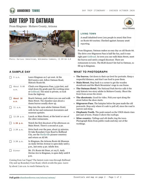
Main Street is about a quarter mile of wooden storefronts, saloons and gift shops along the old highway. Legends of America reports daily gunfight shows in the street. The Oatman Hotel and the 1915 Oatman Drug Company building are both on the National Register. Mine dumps and tailings surround the town. The pale flat at the top of the aerial view below is tailings at the north end, near the old United Eastern shafts.
The historic USGS sheets further down trace the camp's life. The 1886 sheet predates it and shows only a road line crossing the range south of Mount Nutt. The 1942 and 1954 sheets mark Oatman and Goldroad on the highway, and the 1954 map prints “Numerous Mine Shafts” west of town. The detailed 1967 Oatman sheet shows the street grid, the United Eastern and Tom Reed mines, tailings and a cemetery. The 1982 sheet names the Tom Reed, Goldroad, Midnight, Pioneer and Black Eagle mines around Elephants Tooth.
- Oatman Hotel (1902)
- Oatman Drug Company building (1915)
- Wooden storefronts on Main Street
- United Eastern mine site
- Tom Reed mine site
- Tailings
- Cemetery
- Old Route 66 grade over Sitgreaves Pass


Historic maps
Oatman on USGS maps, 1886–1982
Crops from the USGS Historical Topographic Map Collection, centered on the townsite. Each sheet shows what surveyors mapped that year; compare them with today's topo and aerial on this page.

Day trip
Plan a day trip to Oatman from Kingman
Take it with you
Day trip itinerary
The essentials, the sample day with boxes to tick, what to photograph and the coordinates, on two printable pages. Handy where there's no signal.
Download the PDF (449 KB)From Kingman, Oatman makes an easy day on old Route 66. The drive over Sitgreaves Pass is half the fun, and it runs right past Goldroad. In town you can walk Main Street, meet the burros and catch a staged shootout. There are restaurants in town. The BLM doesn't list fuel in Oatman, so fill up in Kingman.
A sample day
- Leave Kingman on I-40 west. At the McConnico exit, follow Oatman Road, Historic Route 66.
- Climb over Sitgreaves Pass, 3,550 feet, and wind down the grade past the working mine at Goldroad. The mine is private, so look from the highway.
- Reach Oatman, park where you can and walk Main Street. The chamber says about a dozen burros usually show up.
- Step into the 1902 adobe Oatman Hotel, with its bar and restaurant downstairs and museum upstairs.
- Lunch on Main Street, at the hotel or one of the other restaurants.
- Watch the first shootout of the afternoon on Main Street. There's a second at 3:30.
- Drive back over the pass, about 55 minutes. Or take Boundary Cone Road to Bullhead City, see the Hardyville pioneer cemetery and return on AZ 68.
- In Kingman, the Arizona Route 66 Museum on Andy Devine Avenue is open daily until 5 p.m., last entry 4:30. Adults $10.
- Mr. D'z Route 66 Diner, at 105 E. Andy Devine Ave in Kingman, is open daily until 8 p.m.
Coming from Las Vegas? The fastest route runs through Bullhead City and up Boundary Cone Road, which avoids the pass. Leave by about 7:20 a.m. to reach Oatman by 10.
What to photograph and film
- The burros. Get down to their eye level for portraits. Keep a respectful distance, and don't use food to pose them.
- Main Street. Step back to a corner to get the wooden storefronts and the Black Mountains' crags in one frame.
- The Oatman Hotel. The National Park Service calls it the only historic two-story adobe in Mohave County. Shoot the front from across the street.
- The shootouts. Good for video. Pick your spot along the street before the show starts.
- Sitgreaves Pass. The hairpins below the pass made the old postcards. Stop only where it's safe to pull off, since the road is narrow and steep.
- Elephants Tooth. The peak named on the USGS sheets rises just east of town. Frame it above the rooftops.
- Mine country. Tailings and old shafts ring the town. Photograph them from public roads and stay out of the workings.
Map & directions
Getting there
Kingman is the classic approach. The route follows Historic Route 66 west over Sitgreaves Pass and down through Goldroad into Oatman. From Las Vegas, the fastest route runs south through Laughlin and Bullhead City and climbs to Oatman on Boundary Cone Road, which avoids the pass. The BLM describes the Route 66 byway as paved all the way.


Base map: USGS The National Map (public domain). Routes: OSRM on © OpenStreetMap contributors data (ODbL), computed October 2026. Times assume dry roads.
- From downtown Kingman, follow East Beale Street to I-40.1.2 mi
- Take I-40 west and leave at the McConnico exit, which the BLM lists as exit 44.4.2 mi
- Turn right on Shinarump Road, then left onto Oatman Road (County Route 10, Historic Route 66). It crosses the valley, climbs over Sitgreaves Pass and drops past Goldroad into Oatman.23 mi
- Take I-11/US 93/US 95 south past Boulder City.22.4 mi
- Leave I-11 at exit 14 and follow US 95 south.54.3 mi
- Turn left on the Colorado River Highway (SR 163) toward Laughlin. Continue into Arizona on AZ 95 and Bullhead Parkway.29.2 mi
- Turn left on Mohave Valley Highway (AZ 95).6.3 mi
- Turn left on Boundary Cone Road (County Route 153). It becomes Oatman Road and climbs into town.13.7 mi
Road and safety notes
- Oatman Road over Sitgreaves Pass (3,550 ft) is paved but narrow, with hairpin curves and steep grades. Posted limits run from 20 to 45 mph, and the BLM recommends an automatic transmission.
- Vehicles over 40 feet aren't allowed over the pass between Golden Valley and Oatman. Legends of America suggests big rigs and trailers approach from Topock, to the south.
- Parking in town is very limited, and RVs and trailers may struggle to find a space.
- Burros stand in the road in and around town. Drive slowly and don't feed them on the pavement.
- The BLM lists fuel in Kingman, Golden Valley, Bullhead City and Fort Mohave. Carry water, a spare tire and food on the byway.
- Summer heat is severe. The BLM recommends October through April, and flash floods can hit after storms.
Photos
Oatman in photos
Visitor reports
Been to Oatman?
Been there lately? Tell the next visitor what you found: whether you could get in, the state of the road and what's still standing. Photos are welcome. We read every report before it appears here.
Gold mining
More gold mining ghost towns
The nearest in Arizona.

 Guide
Goldroad
35.05, -114.38Mohave County, Arizona
A gold camp on the Route 66 grade just above Oatman, razed for taxes in 1949. The mine beneath it is working again, so the townsite is private and…
 Guide
Katherine
35.23, -114.55Mohave County, Arizona
A gold camp that boomed in the 1920s and closed in World War II. The town is gone and the mill ruins are fenced off. Its name lives on at Katherine…
Nearby
Other sites near Oatman
Straight-line distance from the townsite to other mapped sites in our Arizona index.
- Goldroad1.3 mi N · Mohave
- Hardyville13.2 mi NW · Mohave
- Fort Mohave13.5 mi W · Mohave
- Mohave City13.6 mi W · Mohave
- Polhamus Landing15.5 mi NW · Mohave
- Katherine17.0 mi NW · Mohave
- Eastbridge18.1 mi SW · Mohave
- Powell20.1 mi S · Mohave
Sources
Sources and credits
- ghosttowns.com, "Oatman": fact sheet fields (roads, legal description, climate, best time, remains).
- Wikipedia, "Oatman, Arizona", retrieved October 2026: Olive Oatman, 1863 claims, 1915 strike, production by 1941, 1921 fire, 2020 census, the Gable and Lombard dispute, coordinates.
- Wikipedia, "County Route 10 (Mohave County, Arizona)": the September 17, 1952 bypass (citing the Arizona Republic), the 1955 transfer to the county, Sitgreaves Pass elevation.
- National Park Service, "Durlin Hotel", updated March 2026: hotel history, National Register listing, Route 66 1926–1952, 1924 and 1941 closures, current use.
- Legends of America, "Oatman, Arizona – A Living Ghost Town", updated October 2026: Vivian, the 1909 renaming, Tom Reed strike, production by 1930, gunfight shows, parking.
- BLM, "Route 66 Oatman Road Back Country Byway": 40 ft length limit, grades and speed limits, exit 44, fuel, season and safety notes.
- BLM, "Black Mountain Herd Management Area": herd area, target population and the burros' mining origins.
- Arizona Republic, "Where burros roam and tourists swoon" (January 2024): the 2024 roundup, herd size, the town group and feeding.
- Route 66 News (April 2020): Mohave County's no-feeding-in-the-roadway signs.
- azfamily (January 2026): current population and visitor numbers, the 1990s revival, the Route 66 centennial.
- Wikipedia, "List of ghost towns in Arizona": the 1915 Oatman Drug Company building on the National Register.
- Oatman-Gold Road Chamber of Commerce, official site, with its "Events" and "Burros" pages, as of October 2026: shootout times, the number of burros in town, the feeding warning.
- Explore Kingman, "Day trip: Oatman" (Kingman Office of Tourism), checked October 2026: daily gunfights, the chamber's contacts.
- Mohave County Historical Society, "Arizona Route 66 Museum" and admission, as of October 2026: hours, address and admission.
- Explore Kingman, "Discover Kingman Route 66" (posted February 2025, checked October 2026): Mr. D'z Route 66 Diner, its address and hours.
- USGS survey photo captions, 1921, via Wikimedia Commons: shaft names, including the Olla Oatman shaft. Elevation: USGS 3D Elevation Program point query. Routes: OSRM on OpenStreetMap data, October 2026. Status checked against the sources above on October 19, 2026.
Photo and map credits
- A burro on Main Street, 2016: Dariusz Jemielniak, Wikimedia Commons, CC BY-SA 4.0
- The welcome sign at the south end of town, April 2026: G. Edward Johnson, Wikimedia Commons, CC BY 4.0
- Oatman under the crags of the Black Mountains, 2024: Cullen328, Wikimedia Commons, CC BY-SA 4.0
- A Main Street storefront, 2024: Zongxianglee, Wikimedia Commons, CC BY 4.0
- The Oatman Hotel, built of adobe in 1902: Ivan Salas from Inglewood CA, USA, Wikimedia Commons, CC BY 2.0
- Oatman from end to end, March 2025: Gordon Leggett, Wikimedia Commons, CC BY 4.0
- Burros among the visitors, 2016: Dariusz Jemielniak, Wikimedia Commons, CC BY-SA 4.0
- United Eastern shafts at the north end of town, USGS 1921: USGS, Wikimedia Commons, Public domain
- Looking toward Oatman along the Tom Reed vein, USGS 1921: USGS, Wikimedia Commons, Public domain
- Main Street and the Arizona Hotel, undated postcard: Unknown author, Wikimedia Commons, Public domain
- Horseshoe curves on US 66, Gold Road grade east of town, postcard: Unknown author, Wikimedia Commons, Public domain
- Old Route 66 crossing the desert near Oatman, 2024: Zongxianglee, Wikimedia Commons, CC BY 4.0
- Area base map, topo and aerial imagery: USGS The National Map (public domain).
- Historic maps: USGS Historical Topographic Map Collection (public domain): Camp Mohave 1886, 1:250,000; Camp Mohave 1942, 1:250,000; Kingman 1954, 1:250,000; Oatman 1967, 1:24,000; Davis Dam 1982, 1:100,000.