 Abandoned

Overview
Two years of silver on Harshaw Creek

Harshaw lies on Harshaw Creek at the north end of the Patagonia Mountains, about eight miles southeast of Patagonia. It's named for David Tecumseh Harshaw, a former California Column sergeant turned rancher. After the Indian agent Tom Jeffords ordered his cattle off Apache land, he moved them here, took up prospecting and staked silver claims. One of them became the Hermosa Mine.
The Hermosa Mining Company built a 20-stamp mill, and the camp filled fast. The post office opened in April 1880, and that year the mine turned out about $365,000 in bullion in four months. The census counted 640 people. Harshaw had about 200 buildings along its main street, including stores, hotels, breweries and saloons, and a newspaper, the Arizona Bullion. It didn't last. In late 1881 the ore got poorer, the mine and mill closed, and a fire set off by a thunderstorm damaged the town. By 1882 the Tombstone Epitaph found most of the buildings empty, "with broken windows and open doors."
James Finley of Tucson bought the Hermosa in 1887 and kept a smaller camp going until he died in 1903, when the post office closed. ASARCO mined nearby from 1937 to 1956. The townsite became part of the Coronado National Forest in 1953, and most of what stood here was torn down in the 1970s. Today the Hale Ranch, a working cattle ranch, holds the 1870s Finley House and a few adobe homes, and a cemetery sits beside the road. Mining is back in the district, too. South32 is building its Hermosa zinc, silver and manganese mine in these mountains.
Timeline
From Durazno to Hermosa

- A 1764 missionary account says Apaches destroyed Durazno, a Spanish settlement on this site, on February 19, 1743.
- Ordered off Apache land by the Indian agent Tom Jeffords, rancher David Harshaw moves his cattle to Harshaw Creek. Some accounts date this to 1877.
- The Hermosa Mine is located. A brick house for the mine superintendent, later Finley's home, goes up about the same time.
- Harshaw sells a claim to the Hermosa Mining Company, which starts building a 20-stamp mill.
- The post office opens under the name Harshaw. The Arizona Bullion newspaper launched the day before.
- The mill starts on August 5. The Hermosa turns out about $365,000 in bullion in four months, and the census counts 640 people.
- Ore quality drops and the mine and mill close. A fire set off by a severe thunderstorm damages the town.
- The Tombstone Epitaph finds most of Harshaw's buildings standing empty.
- Tucson's James Finley buys the Hermosa for $600 and restarts work on a smaller scale. One source puts his purchase in 1890.
- The Hardshell Mine, found by David Harshaw in 1879, begins producing silver.
- Finley dies, the Hermosa closes again and the post office shuts.
- A 15,000-acre forest fire forces the camp's 50 or so residents out. It is contained on May 13, just short of town.
- ASARCO works the nearby Flux and Trench mines.
- The townsite is taken into the Coronado National Forest. Most residents never held title to their lots.
- About 70 people still live here. The Forest Service tries to relocate them, without success.
- The James Finley House is listed on the National Register of Historic Places.
- Locals and the Forest Service tear down most of the remaining buildings.
- The Forest Service issues its final decision on South32's Hermosa mine project in the same district.
Record check
Numbers that don't agree
Harshaw's boom was short and its records are patchy, so the figures you'll read about it vary a lot. Here is how they line up.
Population. Several guides say Harshaw had 2,000 people around 1881. The 1880 census counted 640, and the town was already in decline a year later, so the larger figure is hard to document. The count fell to about 150 by 1884 and recovered to 260 in 1890.
Saloons and streets. Accounts give anywhere from seven to thirty saloons, and a main street of three-quarters of a mile to a full mile. Wikipedia's figure is about 200 buildings, 30 of them commercial.
Dates. Harshaw's arrival on the creek is given as 1873 in one account and 1877 in others, the year the Hermosa was located. James Finley's purchase is dated 1887 in most sources and 1890 in the history of his house.
The production figure is steadier. Sources agree on about $365,000 from the Hermosa in four months of 1880.
What's left
A brick house, adobe walls and two cemeteries


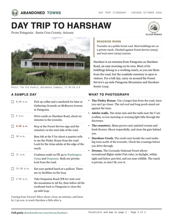
A Forest Service sign marks the Harshaw Townsite. The best-known building is the James Finley House, a three-room brick house from about 1877 built with red bricks salvaged from a smokestack at Mowry, five miles south. Adobe rooms and a porch were added later. It stands on private ranch land across the road from the Hale Ranch headquarters and isn't open to visitors. The ranch also holds two adobe homes, parts of which date to the 1880s, and the foundations of the Hermosa Mill, a 1940s school and church, and an assay office.
FR 49 reaches a Y intersection at the townsite. A decaying adobe house stands just east of it, and the cemetery is on the west side of the road. Bear left at the Y for about a quarter mile to see the Finley House from the road. Another adobe shell, once the house and pool hall of Ignacio Arias, stands at the edge of the ranch. The main cemetery, north of the ranch headquarters and beside the road, is known locally as the Mexican cemetery for the many Mexican-American pioneers buried there. A second, the American cemetery, is on private land.
The historic maps below show the town's shape. The 1905 sheet marks Harshaw beside Hardshell and Hermoso Hill, with the Mowry Mine to the south. The 1948 sheet shows a long line of buildings along the road and creek. By 1996 only a handful are left.
- James Finley House (c. 1877, private)
- Hale Ranch adobe homes (private)
- Arias adobe house and pool hall ruin
- Hermosa Mill foundations
- School and church foundations
- Assay office footing
- Mexican cemetery (roadside)
- American cemetery (private)
- Mine dumps and shafts in the hills


Historic maps
Harshaw on USGS maps, 1905–1996
Crops from the USGS Historical Topographic Map Collection, centered on the townsite. Each sheet shows what surveyors mapped that year; compare them with today's topo and aerial on this page.

Day trip
Plan a day trip to Harshaw from Patagonia
Take it with you
Day trip itinerary
The essentials, the sample day with boxes to tick, what to photograph and the coordinates, on two printable pages. Handy where there's no signal.
Download the PDF (589 KB)Harshaw is 20 minutes from Patagonia on Harshaw Road, an easy morning on its own. Most of its buildings belong to a working ranch, so you see them from the road, but the roadside cemetery is open to visitors. For a full day, carry on around the Forest Service's 45-mile Patagonia Mountains and Harshaw Scenic Loop.
A sample day
- Pick up coffee and a sandwich for later at Gathering Grounds on McKeown Avenue in Patagonia.
- Drive south on Harshaw Road, about 20 minutes to the townsite.
- Stop at the Forest Service sign and the cemetery on the west side of the road.
- Bear left at the Y for about a quarter mile to see the Finley House from the road. Look for the Arias adobe at the edge of the ranch.
- Continue south on FR 49 to Washington Camp and Duquesne. Both are private; look from the road.
- Eat your packed lunch at a pullout. There are no facilities on the loop.
- Take Duquesne Road (FR 61) west over the mountains to AZ 82, then follow AZ 82 northeast back to Patagonia to close the 45-mile loop.
Coming from Tucson? Allow about 1 hour 40 minutes, and leave by 7:30 a.m. to reach Harshaw a little after 9.
What to photograph and film
- The Finley House. Use a longer lens from the road, since you can't go closer. The red roof and long porch stand out against the trees.
- Adobe walls. The Arias ruin and the walls near the Y are roofless, so low morning or evening light falls through the doorways.
- The cemetery. Many graves carry painted crosses and fresh flowers. Shoot respectfully, and close the gate behind you.
- Harshaw Creek. The creek runs beside the road under big trees north of the townsite. Check the crossings before you drive through.
- Drones. The Coronado National Forest allows recreational flights under FAA rules, in daylight, within sight and below 400 feet, and not near wildlife. The ranch is private, so don't fly over it.
Map & directions
Getting there
Patagonia is the closest town, about 8 miles away. From Tucson, the fastest route runs east on I-10 and south through Sonoita on AZ 83 and AZ 82. Both finish on Harshaw Road, which the Forest Service numbers FR 58 and then FR 49. It's also a Forest Service scenic drive that runs about 10 miles from Patagonia to FR 61, just west of Washington Camp and Duquesne.


Base map: USGS The National Map (public domain). Routes: OSRM on © OpenStreetMap contributors data (ODbL), computed October 2026. Times assume dry roads.
- From downtown Patagonia, follow Naugle Avenue (AZ 82) and turn left on McKeown Avenue.0.4 mi
- McKeown Avenue becomes Harshaw Avenue on the way out of town.1.1 mi
- Continue on Harshaw Road (FR 58) up the Harshaw Creek valley.4.8 mi
- Keep right where Harshaw Road continues as FR 49.1.9 mi
- Turn onto the Harshaw townsite road.0.1 mi
- From downtown Tucson, take Congress Street to I-10 and head east on the Tucson–Benson Highway to exit 281.23.7 mi
- Turn right onto AZ 83, the Sonoita Highway, and follow it south.25.1 mi
- Where AZ 83 ends at Sonoita, turn right onto AZ 82 and follow it to Patagonia.12.3 mi
- In Patagonia, turn left on McKeown Avenue. It becomes Harshaw Avenue, then Harshaw Road (FR 58).6.0 mi
- Keep right on Harshaw Road (FR 49) to the townsite road.2.0 mi
Road and safety notes
- Arizona Highways describes Harshaw Road as paved to the T junction about 6 miles out and for a stretch beyond, then mostly smooth dirt to the townsite. It recommends high clearance, says four-wheel drive isn't needed in good weather, and advises against the drive after heavy rain or with rain in the forecast. The Forest Service gives the same high-clearance advice for these mountains.
- Harshaw Creek crosses Harshaw Road four times. Since South32's Hermosa project began releasing treated mine water into the creek, the crossings without a hard base have been getting deeper (Patagonia Regional Times, February 2025). Check the depth before you drive through.
- This is a working road. Ranch trucks use it, and South32 has run traffic for its Hermosa site down Harshaw Road.
- There's no drinking water, restroom or fuel past Patagonia, and cell service is limited. Fill up and carry water before you leave town.
- Border Patrol is active on these back roads. Expect to see agents and possibly a vehicle stop.
- Most buildings are on private ranch land. Stay on the road, and respect fences, gates and posted signs.
Photos
Harshaw in photos
Visitor reports
Been to Harshaw?
Been there lately? Tell the next visitor what you found: whether you could get in, the state of the road and what's still standing. Photos are welcome. We read every report before it appears here.
Silver mining
More silver mining ghost towns
The nearest in Arizona.

 Guide
Mowry
31.43, -110.70Santa Cruz County, Arizona
A silver-lead mine worked since the 1850s and named for a Confederate-leaning promoter of Arizona Territory. Stone and adobe ruins remain on a…
 Guide
Washington Camp
31.38, -110.69Santa Cruz County, Arizona
The older of two twin mining camps in the southern Patagonia Mountains. It held the district's mill and more than 1,000 people around 1901, and a few…
Nearby
Other sites near Harshaw
Straight-line distance from the townsite to other mapped sites in our Arizona index.
- Mowry2.7 mi S · Santa Cruz
- Washington Camp6.0 mi S · Santa Cruz
- Duquesne6.8 mi S · Santa Cruz
- La Noria10.3 mi SE · Santa Cruz
- Salero11.9 mi NW · Santa Cruz
- Canelo12.5 mi NE · Santa Cruz
- Fort Buchanan13.1 mi N · Santa Cruz
- Alto13.9 mi NW · Santa Cruz
Sources
Sources and credits
- ghosttowns.com, "Harshaw": fact sheet fields (roads, legal description, climate, best time, remains, post office dates).
- Wikipedia, "Harshaw, Arizona", retrieved October 2026: Durazno, founding, mill, census figures, production, 1929 fire, ASARCO, Forest Service history, coordinates and elevation (GNIS 29768).
- Wikipedia, "James Finley House" and "Hale Ranch", retrieved October 2026: the house, its Mowry bricks, the National Register listing, ranch buildings, cemeteries and access.
- Legends of America, "Patagonia Back Road Ghost Towns": the route from Patagonia, the 1887 purchase, road and Border Patrol notes, private-property warning.
- AZOffroad.net, "Harshaw": saloon count, Hermosa production figure, cemetery location.
- Arizona Highways, "Patagonia Ghost Towns" (scenic drive, read October 2026): road surface and mileages, vehicle advice, the Y intersection, viewing the Finley House from the road.
- Coronado National Forest, "Harshaw Road #58, 49, 61 and HWY 82 Scenic Drive": road numbers, scenic drive, no water, restrooms or fees.
- Coronado National Forest, "Patagonia Mountains and the San Rafael Valley Visitor Guide" (May 2025): road conditions, high clearance, historic townsite on the map, water and cell service, the nearest water in Patagonia, fuel advice, the 45-mile scenic loop.
- Patagonia Regional Times, "Hermosa Water Discharge Impacting Crossings" (February 7, 2025): creek crossings on Harshaw Road.
- Patagonia Regional Times (September 2023): South32 traffic on Harshaw Road.
- South32 Hermosa, "U.S. Forest Service Issues Final Record of Decision" (July 7, 2026): status of the Hermosa mine project.
- Douglas Kreutz, "A ghost town graveyard preserves memories of long-ago townspeople," Arizona Daily Star (2017, updated 2018): the townsite and cemetery on Forest Service land, the cemetery open to the public, closing the gate.
- Coronado National Forest, "Drones / Unmanned Aircraft Systems (UAS)": recreational use only, FAA rules, 400-foot ceiling, daylight and line of sight, no flights near wildlife, campgrounds, picnic areas, trailheads or visitor centers, none in wilderness.
- 36 CFR 261.9: the ban on removing or damaging historic and archaeological resources on national forest land.
- Gathering Grounds, official site: McKeown Avenue address, coffee, sandwiches and soups, as of October 2026.
- Town of Patagonia, "Well Worth the Drive": shaded picnic tables in the central park, as of October 2026.
- Coordinates: USGS Geographic Names Information System. Elevation check: USGS 3D Elevation Program (about 4,870 ft). Routes: OSRM on OpenStreetMap data, October 2026. Status checked against the sources above on October 19, 2026.
Photo and map credits
- Harshaw in the 1880s: Unknown author, Wikimedia Commons, Public domain
- The Hermosa Mill under construction, 1879: Unknown author, Wikimedia Commons, Public domain
- The James Finley House, 2014: The Old Pueblo, Wikimedia Commons, CC BY-SA 4.0
- The Forest Service townsite sign: The Old Pueblo, Wikimedia Commons, CC BY-SA 4.0
- Ruin of the Arias adobe house and pool hall: The Old Pueblo, Wikimedia Commons, CC BY-SA 4.0
- Adobe walls in the townsite: The Old Pueblo, Wikimedia Commons, CC BY-SA 4.0
- The roadside cemetery, 2014: The Old Pueblo, Wikimedia Commons, CC BY-SA 4.0
- The grave of Angel Soto, 1846–1899: The Old Pueblo, Wikimedia Commons, CC BY-SA 4.0
- Graves and flowers in the cemetery, 2007: dedhed1950, Wikimedia Commons, CC BY-SA 2.0
- An adobe doorway, 2004: Transity, Wikimedia Commons, CC BY-SA 3.0
- Harshaw Creek, northeast of the townsite: The Old Pueblo, Wikimedia Commons, CC BY-SA 4.0
- Area base map, topo and aerial imagery: USGS The National Map (public domain).
- Historic maps: USGS Historical Topographic Map Collection (public domain): Nogales 1905, 1:125,000; Lochiel 1932, 1:62,500; Harshaw 1948, 1:24,000; Harshaw 1958, 1:24,000; Harshaw 1996, 1:24,000.