 Abandoned

Overview
A camp on Battle Mountain
Independence grew up in 1894 on the south slope of Battle Mountain, in the Cripple Creek district, beside the Independence, Vindicator, Hull City and Findley mines. It grew up near Winfield Scott Stratton's Independence mine, staked in 1891. Goldfield lay just across Montgomery Gulch, on the other side of the Midland Terminal tracks, and piped Independence its water. By 1900 about 500 people lived there.
Katy Bemore, who moved there in 1898, remembered in a 1952 interview a crowded town of doctors, dry goods stores, dance halls and saloons, with streetcars to the rest of the district and a school that ran through eighth grade. Her family made a home of an abandoned mine's engine and hoist rooms.
Independence is remembered for one night. On June 6, 1904, during the Colorado Labor Wars, a bomb blew up the platform of the Independence depot as non-union miners gathered on their way to the night shift at the Findley mine. Thirteen men died and six were hurt. (A 1952 local account put the blast at 2 a.m., as men came off shift.) The mine owners and the Citizens' Alliance answered by driving union officials out of office and deporting union miners; within days the Western Federation of Miners was finished in the district. By the end of the strike about half the homes in the area stood empty.
The camp hung on with the mines. About ten families still lived there in 1952. Today the Cripple Creek & Victor Gold Mining Company controls most of the old properties, and the Victor Heritage Society says its surface mining has erased the townsite. What survives is next door: the Vindicator mine's ore house and headframe on the Vindicator Valley Trail.
Timeline
Gold, a bombing and the open pit

- Winfield Scott Stratton stakes the Independence claim on Battle Mountain. The town of Independence later grows up near his mine.
- Independence is founded near the Independence Mine on the south slope of Battle Mountain, close to the Hull City, Vindicator and Findley mines.
- Independence draws its water from Goldfield's system across Montgomery Gulch. The Midland Terminal Railroad tracks divide the two towns.
- About 500 people live in Independence.
- During the Colorado Labor Wars a bomb destroys the platform of the Independence depot, killing 13 non-union miners on their way to the night shift at the Findley mine and injuring six.
- By the end of the strike about half the homes in Goldfield stand empty, and Western Mining History says the same of Independence.
- Bus Peters is born in Independence; he goes to work at the Vindicator in 1933.
- About 10 families still live in Independence, per a local newspaper profile.
- Surface mining by the Cripple Creek & Victor Gold Mining Company erases the townsite, per the Victor Heritage Society.
What's left
The Vindicator Valley Trail
Nothing is left of Independence itself. The Victor Heritage Society, in a gallery posted in 2018, says the town has been erased by 21st-century surface mining, and the aerial view below shows the terraced benches and haul roads of the mine where the houses stood. An earlier update to the directory listing for the town said the mine had already removed most or all of the buildings and the tailings, and that fences kept visitors back from the remaining headframes.
The way to see the place is the Vindicator Valley Trail, a loop of about two miles that starts at a small gravel lot on County Road 81 north of Goldfield. Hiking Project gives it 336 feet of climbing, with a high point of 10,218 feet. The Victor Heritage Society lists what survives along it: the Vindicator mine's ore house and gallows frame, the foundation of the Lillie mine, and the Alfred H. Bebee house at the top of the trail. Interpretive signs tell the story of the mines, and the open pit of the working mine is in view. The trail crosses private land, so stay on it.
A hiking video posted on July 12, 2026, shows the trail as it is now: a fenced gravel path, signs at the start warning that parts are steep, uneven and slippery and that the trail is public access through private property, the Vindicator headframe and ore house in rusted sheet iron, an arched stone building with an interpretive sign, the Bebee House sign, old hoists and a steel headframe on the hill.
The old maps show what is gone. The 1951 Cripple Creek South sheet below prints Independence among scattered buildings between Altman and the Vindicator Mine, with Range View Road to the west. The 1894 sheet, made the year the town was founded, shows Battle Mountain with no town yet; by 1901 Independence is on the map beside Goldfield and Victor Pass.
- Vindicator mine ore house and gallows frame (on the trail)
- Lillie mine foundation
- Bebee house, at the top of the trail
- Interpretive signs
- Views of the working open-pit mine


Historic maps
Independence on USGS maps, 1894–1983
Crops from the USGS Historical Topographic Map Collection, centered on the townsite. Each sheet shows what surveyors mapped that year; compare them with today's topo and aerial on this page.

Day trip
Plan a day trip to Independence from Victor
Take it with you
Day trip itinerary
The essentials, the sample day with boxes to tick, what to photograph and the coordinates, on two printable pages. Handy where there's no signal.
Download the PDF (496 KB)Independence itself is gone, but the walk beside it is one of the best in the Cripple Creek district. Drive three miles from Victor through Goldfield to the Vindicator Valley Trail and walk its two-mile loop past the Vindicator mine's headframe and ore house, with the working open pit in view. The trail crosses private land: stay on the marked trail and keep away from the mine fences.
A sample day
- Drive north from Victor on County Road 81 through Goldfield to the trail parking.
- Walk the Vindicator Valley loop: the Vindicator headframe and ore house, the Lillie foundation and the signs.
- From the high point, look across to the open pit where Independence stood.
- Back to Victor for lunch and its mining-era downtown.
What to photograph and film
- The Vindicator headframe. Frame it against Pikes Peak or the mine benches behind.
- Old and new mining. From the top of the loop, a long lens puts the timber headframes and the modern pit in one picture.
Map & directions
Getting there
Victor, three miles south, is the nearest town with services. County Road 81 climbs from Victor through Goldfield past the Vindicator Valley Trail parking. From Colorado Springs, take US 24 west and CO 67 south toward Cripple Creek. The maps buttons go to the trail parking, not the townsite inside the mine.

Base map: USGS The National Map (public domain). Routes: OSRM on © OpenStreetMap contributors data (ODbL), computed October 2026. Times assume dry roads.
- From downtown Victor, take 3rd Street north.0.1 mi
- Turn right on Diamond Avenue, which becomes County Road 81 and runs through Goldfield as Portland Avenue. Stay on CR 81; the trail parking is just before the next turn.2.0 mi
- Turn left on Independence Road (County Road 831) toward the townsite.0.9 mi
- From downtown Colorado Springs, take Nevada Avenue, Colorado Avenue and Limit Street to Cimarron Street (US 24).1.4 mi
- Follow US 24 west.24.6 mi
- Turn left on CO 67 south.13.3 mi
- Turn left on County Road 81.5.2 mi
- Turn right on Independence Road (County Road 831) toward the townsite. The trail parking is a little further south on CR 81.0.9 mi
Directions go to Vindicator Valley Trail parking on County Road 81, where the drive ends, not to the townsite.
Road and safety notes
- The routes end on Independence Road (County Road 831), about 400 m from the GNIS point, which lies inside the mine. We found no source on public use of that road: park at the Vindicator Valley Trail lot on CR 81 instead.
- The Trails and Open Space Coalition lists free but limited gravel parking at the trailhead, and dawn-to-dusk use all year. It warns that winter visits may need traction devices or snowshoes.
- The townsite sits above 10,000 feet. Shade on the trail is limited.
Photos
Independence in photos
Visitor reports
Been to Independence?
Been there lately? Tell the next visitor what you found: whether you could get in, the state of the road and what's still standing. Photos are welcome. We read every report before it appears here.
Gold mining
More gold mining ghost towns
The nearest in Colorado.

 Guide
Saint Elmo
38.70, -106.34Chaffee County, Colorado
A gold and silver camp of 1880 near 10,000 feet in the Sawatch Range. Its main street of false-fronted wooden buildings still stands, a few people…
 Guide
Tin Cup
38.75, -106.48Gunnison County, Colorado
A mining camp of 1879 named for a tin cup of gold, known early on for killing its marshals. It never fully emptied: the old town is now mostly summer…
Nearby
Other sites near Independence
Straight-line distance from the townsite to other mapped sites in our Colorado index.
- Altman0.3 mi NE · Teller
- Goldfield1.2 mi SE · Teller
- Victor1.5 mi S · Teller
- Cripple Creek2.7 mi NW · Teller
- Gillett3.5 mi N · Teller
- Seven Lakes7.7 mi NE · Teller
- Ruxton Park11.5 mi NE · El Paso
- Adelaide12.2 mi S · Fremont
Sources
Sources and credits
- Wikipedia, "Cripple Creek Gold Rush", retrieved October 2026: Independence founded in 1894 near the Independence Mine on the south slope of Battle Mountain, its neighbors, about 500 people by 1900.
- Wikipedia, "Colorado Labor Wars", retrieved October 2026: the Independence depot bombing of June 6, 1904, its 13 dead and six injured, and the aftermath.
- Wikipedia, "Stratton's Independence Mine and Mill": Stratton's claim of July 4, 1891.
- Western Mining History, "Goldfield, Colorado": Independence across Montgomery Gulch, the Midland Terminal tracks, the water supply by 1898, the empty homes after the 1904 strike.
- Victor Heritage Society, "Vindicator Mine" gallery, compiled April 2018: the townsite erased by 21st-century surface mining, the Vindicator post office in Independence, Bus Peters, the surviving ore house and gallows frame, the Lillie foundation, the Bebee house, the company that controls the property.
- Helen Anderson, "District Personalities: Mrs. Katy Bemore," Cripple Creek Gold Rush, May 30, 1952, posted by the Victor Heritage Society, December 2018: town life from 1898, the school, the streetcars, about ten families in 1952.
- Hiking Project, "Vindicator Valley Trail", read October 2026: the 2-mile loop, climb and high point, trailhead coordinates, private land and staying on the marked trail, leashed dogs.
- Trails and Open Space Coalition, "Vindicator Valley Trail", read October 2026: the gravel lot off County Road 81, dawn-to-dusk hours, limited shade, winter traction.
- ghosttowns.com, Independence (Teller County): the fact sheet (road, climate, best time) and an undated update on the buildings removed by mining and the fenced headframes.
- "Vindicator mine - Cripple Creek CO," Wikimedia Commons: the photograph published in McClure's Magazine, 1907.
- Josh Explores, "Hiking the Vindicator Valley Mines Loop | Goldfield & Victor, Colorado", YouTube, posted July 12, 2026: the trail open, its access and caution signs, the standing headframes and buildings (the newest dated report; not embedded, since the creator also films inside buildings).
- Coordinates: USGS GNIS 203907, Independence (historical). Elevation: USGS 3D Elevation Program point query. Routes: OSRM on OpenStreetMap data, October 2026.
Photo and map credits
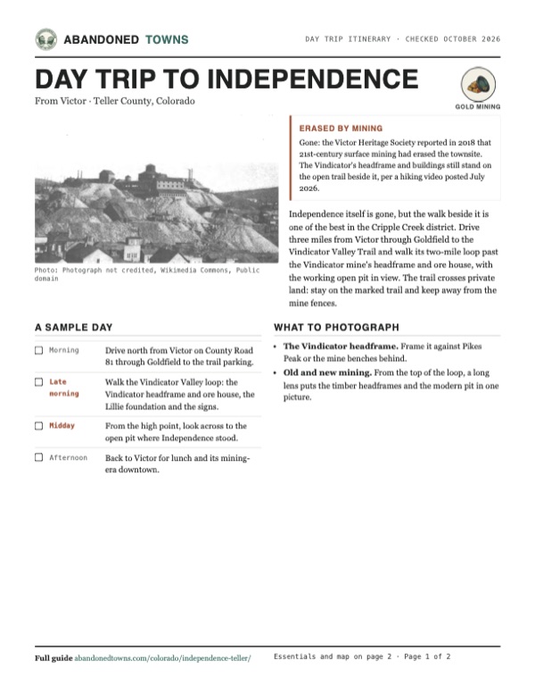
- The Vindicator mine and its dumps above the district's houses, published 1907: Photograph not credited, Wikimedia Commons, Public domain
- Topo map, area base map and aerial imagery: USGS The National Map (public domain).
- Historic maps: USGS Historical Topographic Map Collection (public domain): Pikes Peak 1894, 1:125,000; Pikes Peak 1901, 1:125,000; Cripple Creek South 1951, 1:24,000; Pueblo 1962, 1:250,000; Pikes Peak 1983, 1:100,000.