 Abandoned
Overview
Factory Hollow and the Gay family

Gay City is the mill village inside Gay City State Park, on the Blackledge River between Hebron and Bolton. In 1796 Elijah Andrus led a group of religious followers from Hartford into the isolated hollow. DEEP's page says they were Methodists who had left Hartford over its alcohol restrictions; the Bolton town historian, Hans DePold, retells traditions about liquor served at worship and feuds driving families away. He presents these as legends. Andrus himself left within about four years. John Gay became the colony's "president" and the Rev. Henry Peterson Sumner its spiritual leader, and the two did not get on. The village grew to about 25 families, most of them named Gay.
In 1804 the colony built a woolen mill on the river, with a dam and a canal, and the place became Factory Hollow. The mill ran as William Strong and Company around 1810, failed after the War of 1812, was taken over by Sumner as the Lafayette Manufacturing Company, and burned in 1830. The Gays moved to Bolton. Dr. Charles F. Sumner later built a rag paper mill, which kept the village alive until it too burned, in 1879. DePold's line is that Gay City as much as died with it.
The land passed to the state in 1943, by Wikipedia's account, or 1953, by DePold's. DePold says the Sumners suggested naming the park for the Gay family. His account calls the Gays the last to leave but also says they moved after the 1830 fire; those claims conflict. Gay City State Park became official in 1946 as Connecticut's 54th state park, with 680 acres, and now covers more than 1,500 acres against Meshomasic State Forest. The cellar holes, stone walls, the mill canal and the mill ruins lie along the trails, a short walk from the parking lots.
Timeline
Colony, mills, fires, park
- Elijah Andrus leads a group of religious followers from Hartford into the hollow on the Blackledge River. DEEP's page calls them Methodists who left Hartford over its alcohol restrictions.
- Andrus leaves after about four years. John Gay becomes the colony's "president" and the Rev. Henry Peterson Sumner its spiritual leader. The two don't get on. The village grows to about 25 families, most of them Gays.
- The colony builds a woolen mill on the river, with a dam and a canal. The place becomes Factory Hollow.
- The mill runs as William Strong and Company. It fails after the War of 1812 and the recession that follows.
- Henry P. Sumner takes control and runs the mill as the Lafayette Manufacturing Company.
- Fire ends woolen production. The Gay family moves to Bolton.
- Dr. Charles F. Sumner builds a rag paper mill, which revives the village for a time. The buttons found on the site came from the rags, not from a button factory.
- The paper mill burns. The village goes with it.
- The land passes to the state, in 1943 by Wikipedia's account and 1953 by Bolton's town historian. DePold says the rival Sumners suggested the Gay name. His claim that the Gays left last conflicts with his account of their departure after the 1830 fire.
- Gay City State Park becomes official as Connecticut's 54th state park, with 680 acres.
- DEEP's current trail map is drawn, marking the mill ruins below Gay City Pond.
- The park covers more than 1,500 acres and opens daily from late April to Columbus Day.
Legend and record
Firewater, a peddler and a blacksmith's boy
Two murders are told of Gay City. A jewelry peddler, in some tellings a preacher or a drover, was killed before the Civil War and his remains found in a charcoal pit; nobody was caught, and his ghost is said to haunt the pit. A teenage assistant to the village blacksmith, late for work, was killed with a butcher knife; nobody was tried, and his ghost is said to hurry through the woods, sometimes carrying his head. Another local story concerns a horse thief whipped at a tree on what is now French Road, remembered as the Whipping Tree.
DePold tells these as local lore, and Wikipedia sums them up as grisly murders gone unpunished. We found no court record or contemporary account, so we keep them on the page as legends. DePold also labels the liquor-service stories as tradition and legend. The documented mill fires provide the clearest explanation for the village's decline.
What's left
What you'll see on the trails


DEEP's trail map marks the mill ruins just below Gay City Pond, beside the picnic area and the small lot at the end of the park road, reached by the white trail. Stone foundations stand in the woods south of the pond and west of the yellow trail, the mill canal and dam survive as ditches and walls, and the 1967 USGS sheet in the historic maps below marks a Gay Cemetery south of the park road near Route 85; DEEP's page calls it antiquated. The 1944 sheet shows Gay City Road crossing the hollow before the park road existed, and the 1953 sheet is the first to print the park's name. Split Rock, a cleft boulder on the trail of the same name, is the park's other landmark.
The five-mile red loop tours the whole park. The blue-blazed Shenipsit Trail crosses it on foot only; the other trails are open to bikes as well. A trail runs south through Meshomasic State Forest to Blackledge Falls in Glastonbury.
- Mill ruins below Gay City Pond
- Stone foundations south of the pond
- Mill canal and dam
- Stone walls
- Gay Cemetery
- Split Rock


Historic maps
Gay City State Park on USGS maps, 1892–1986
Crops from the USGS Historical Topographic Map Collection, centered on the townsite. Each sheet shows what surveyors mapped that year; compare them with today's topo and aerial on this page.

Day trip
Plan a day trip to Gay City State Park from Manchester
Take it with you
Day trip itinerary
The essentials, the sample day with boxes to tick, what to photograph and the coordinates, on two printable pages. Handy where there's no signal.
Download the PDF (628 KB)From Manchester, Gay City is an easy half day, and a full one if you swim or walk the whole loop. The mill ruins are a short walk from the end of the park road, the pond has a beach, and the red trail circles the park in about five miles. Bring food and water: DEEP's page lists none for sale.
A sample day
- Leave Manchester by Porter Street, Camp Meeting Road and CT 85, about a quarter of an hour.
- Follow the park road past the fork to the small lot at its end. Walk the white trail to the mill ruins below the pond.
- Take the yellow trail south along the Blackledge River to the stone foundations, then the red loop or the Split Rock Trail.
- Picnic by the pond. In summer, swim from the beach.
- Return by your chosen park trail and leave before sunset. Check posted gate notices before setting out.
Coming from Hartford? The cached route estimates 23 minutes to the entrance via I-384, before the park road and walking.
What to photograph and film
- The mill ruins. Below the pond beside the picnic area. Morning light comes through the trees from the east.
- Cellar walls. The moss-covered foundations south of the pond, west of the yellow trail, are the clearest trace of the village.
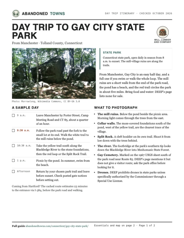
- Split Rock. A cleft boulder on its own trail. Shoot it from low down with the trees behind.
- The river. The footbridge at the park's southern tip looks down the Blackledge River into Meshomasic State Forest.
- Gay Cemetery. Marked on the 1967 USGS sheet south of the park road near Route 85. DEEP's page mentions it but does not give a visitor route; ask the park office before looking for it.
- Drones. DEEP prohibits drones in state parks unless specifically authorized by the Commissioner through a Special Use License.
Map & directions
Getting there
Manchester is the nearest city, about a quarter of an hour away by Camp Meeting Road and CT 85. From Hartford, I-84 and I-384 lead to CT 85 in Bolton. Both routes stop at the park entrance on North Street (CT 85) in Hebron. The park road and walk to the mill site are additional to the displayed route distances.


Base map: USGS The National Map (public domain). Routes: OSRM on © OpenStreetMap contributors data (ODbL), computed October 2026. Times assume dry roads.
- From East Center Street (US 6/US 44), turn onto Porter Street and follow it southeast.2.1 mi
- At the end of the road, turn left onto Camp Meeting Road.2.5 mi
- Continue as West Street (CT 85) into Hebron. The park entrance is on North Street (CT 85).2.4 mi
- From Pearl Street, take State Street to CT 2, then the ramp to I-84 east.1.8 mi
- Take the fork onto I-384 east toward Providence, then the ramp for CT 85 toward Bolton and Colchester.10.0 mi
- Turn right onto Bolton Center Road (CT 85), right again onto Clark Road, and follow CT 85 south as West Street to the park entrance on North Street.4.2 mi
Road and safety notes
- The gates are open daily from late April to Columbus Day, 8 a.m. to sunset. Parking is available off-season.
- Out-of-state vehicles pay $10 on weekdays and $15 on weekends and holidays; Connecticut plates park free. Buses seating 30 or more need a permit.
- The park road ends at a small lot with access to the white trail, which leads to the mill ruins.
- The Shenipsit Trail is foot travel only. The park's other trails are non-motorized multi-use.
Photos
Gay City in photos
Visitor reports
Been to Gay City State Park?
Been there lately? Tell the next visitor what you found: whether you could get in, the state of the road and what's still standing. Photos are welcome. We read every report before it appears here.
Mill, lumber and company
More mill, lumber and company ghost towns
The nearest in Connecticut, then the nearest elsewhere.

 Guide
Johnsonville Village
41.49, -72.47Middlesex County, Connecticut
A twine-mill village on the Moodus River that an aerospace millionaire remade as a Victorian attraction, then abandoned in 1994. A church bought it…
 Guide
Feltville
40.68, -74.39Union County, New Jersey
A stationer's model mill town of the 1840s, then a summer resort, then empty. Union County keeps it as the Deserted Village, open to walk every day…
Nearby
Other sites near Gay City State Park
Straight-line distance from the townsite to other mapped sites in our Connecticut index.
- Johnsonville Village16.3 mi S · Middlesex
- Bloomfield17.4 mi NW · Hartford
- Bara-Hack24.5 mi NE · Windham
- Dudley Town47.4 mi W · Litchfield
- Easton55.1 mi SW · Fairfield
Sources
Sources and credits
- ghosttowns.com, "Gay City": fact sheet fields (roads, remains). Its county, New London, is wrong: Hebron and Bolton are in Tolland County.
- Wikipedia, "Gay City State Park", retrieved October 2026: the 1796 settlement, the mills and fires, the 1943 sale, the 1946 opening with 680 acres, the 1,569 acres today, the five-mile loop, the Blackledge Falls connection, coordinates and elevation.
- Connecticut DEEP, "Gay City State Park", read October 2026: season and hours, parking fees, address and phone, the Methodist founding story, pets, swimming, youth camping, bus permits, the mill site on the white trail, and the cemetery.
- Connecticut DEEP, Gay City State Park trail map (PDF), dated March 17, 2017: the mill ruins, toilets, water, beach, picnic areas, trail blazes and distances, the Shenipsit Trail rule, and the park's three towns.
- Hans DePold, Bolton Historical Society, "Gay City or Factory Hollow", written 2006, dated February 2014: Andrus, Gay and Sumner, the 25 families, the liquor and feuds, the 1804 mill, William Strong and Company, the Lafayette Manufacturing Company, the 1830 and 1879 fires, the paper mill and its buttons, the 1953 date, the naming, and the three legends.
- Connecticut DEEP, Swimming, updated August 2025: Gay City is a designated swimming area; check the water-quality report before swimming.
- Hartford Marathon Foundation, Summer Solstice Trail Run, June 20, 2026 event: dated evidence of organized trail recreation at the park.
- Connecticut DEEP, drone policy, policy page updated December 2022 and read October 2026: drones prohibited without a Commissioner-authorized Special Use License.
- Photos: Wikimedia Commons, credited below each one. Elevation: USGS 3D Elevation Program point query. Routes: OSRM on OpenStreetMap data, October 2026.
Photo and map credits
- A stone cellar wall south of Gay City Pond, June 2020: Morrowlong, Wikimedia Commons, CC BY-SA 4.0
- Split Rock, August 2010: Morrowlong, Wikimedia Commons, CC BY-SA 3.0
- The Blackledge River from the southern footbridge, June 2020: Morrowlong, Wikimedia Commons, CC BY-SA 4.0
- Area base map, topo and aerial imagery: USGS The National Map (public domain).
- Historic maps: USGS Historical Topographic Map Collection (public domain): Gilead 1892, 1:62,500; Marlboro 1944, 1:31,680; Marlborough 1953, 1:24,000; Marlborough 1967, 1:24,000; Hartford 1986, 1:100,000.