 Abandoned

Overview
A governor's mill town on the Suwannee

George Franklin Drew founded Ellaville in 1861 where the Withlacoochee River runs into the Suwannee. With his partner Louis Bucki he built a sawmill that employed more than 500 people, one of the largest in Florida, and the railroad ran a line to its door. Turpentine, logging and railroad-car building added work. In the early 1870s the town had a train station, two schools, two churches, a steamboat dock and a Masonic lodge. Drew was elected governor in 1876.
How big Ellaville got depends on the source. Wikipedia says about 1,000 people; the state marker of 1972 says "several hundred." Who Ella was is disputed too. Wikipedia's text says Drew named the town for a woman he enslaved, and a 2025 WorldAtlas article says a long-time servant. Wikipedia's infobox names Ella Bucki, wife of his partner. None of these is well sourced, and Wikipedia flags its own claim as needing a citation, so we give them all.
The mill burned in 1898 and was rebuilt, but the yellow pine was running out. The town declined after 1900, and the marker says it ceased to exist when the post office closed in 1942. The empty Drew Mansion burned in December 1970. Today the site is woods and a picnic area in Twin Rivers State Forest, with a state marker, a few mansion foundations and the old Hillman Bridge, bypassed in 1986.
Video
Searching the woods for the Drew Mansion
A YouTuber spends two September days on the townsite: the Hillman Bridge, a small cemetery under fallen trees, a storehouse buried in vines and, after three hours, the brick foundations of the Drew Mansion. The creator's tip is to come in winter, when the undergrowth has died back. The history in the narration is the creator's own; the timeline below follows the state marker and our sources.
 Play “Florida's Most Forgotten Ghost Town: What Happened to Ellaville?” from YouTube
Timeline
Mill, railroad, decline and fire

- George Franklin Drew founds Ellaville on the Suwannee River, by Wikipedia's and WorldAtlas's account. The state marker dates his sawmill and manufacturing complex to the mid-1860s.
- Drew builds a two-story mansion with oak parquet floors and formal gardens, about half a mile northwest of today's marker.
- Ellaville's heyday. With his partner Louis Bucki, Drew runs a mill that employs more than 500 people, one of the largest in Florida. The town has a train station, two schools, two churches, a steamboat dock, a Masonic lodge and a commissary.
- Drew is elected governor. He serves from 1877 to 1881.
- The mill burns. It is quickly rebuilt.
- The yellow pine runs out and the town declines. Wikipedia adds floods on both rivers and the Depression.
- The Hillman Bridge, a steel truss built as a Federal Aid Project, carries the highway over the Suwannee at Ellaville.
- The post office closes. The state marker says the town "ceased to exist" with it.
- The empty Drew Mansion burns.
- The two-sided state marker, Drew Mansion Site and The Town of Ellaville, goes up on US 90, sponsored by the family of Robert L. Millinor with the Department of State.
- A new bridge replaces the Hillman Bridge, which is left standing.
What's left
What you'll see

Start at the picnic area on Drew Way, just off US 90 at the west end of the river crossing. The two-sided 1972 marker stands there: one side tells of the Drew Mansion, half a mile to the northwest, and the other of the town. The marker places the sawmill ruins on the west bank of the Withlacoochee near where it meets the Suwannee.
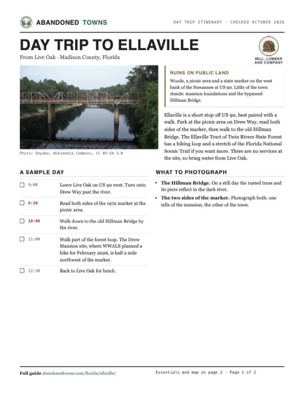
The Hillman Bridge, a steel truss of 1925, still spans the Suwannee beside the newer highway bridge and a CSX railroad bridge. In April 2025 the WWALS Watershed Coalition walked from the town site onto it toward Suwannee County and photographed deadfall and graffiti on the deck. A 2010 photo shows an abandoned store beside the old bridge, its wall lettered "Fine Food and Spirits"; we found no newer report of it. Of the Drew Mansion, WWALS says only some foundation remains are visible.
The 1959 Ellaville sheet below marks the Drew Mansion and a cemetery northwest of the crossing, north of the railroad, and Suwanacoochee Spring near the railroad bridge. Like today's USGS map, it prints the Ellaville name across the Suwannee, on the east bank just north of US 90, with Dean Cemetery beside it.
- Town of Ellaville and Drew Mansion Site marker (1972)
- Drew Mansion foundations
- Hillman Bridge (1925)
- Abandoned store by the bridge (photographed 2010)
- Picnic area, Twin Rivers State Forest


Historic maps
Ellaville on USGS maps, 1954–1979
Crops from the USGS Historical Topographic Map Collection, centered on the townsite. Each sheet shows what surveyors mapped that year; compare them with today's topo and aerial on this page.

Day trip
Plan a day trip to Ellaville from Live Oak
Take it with you
Day trip itinerary
The essentials, the sample day with boxes to tick, what to photograph and the coordinates, on two printable pages. Handy where there's no signal.
Download the PDF (501 KB)Ellaville is a short stop off US 90, best paired with a walk. Park at the picnic area on Drew Way, read both sides of the marker, then walk to the old Hillman Bridge. The Ellaville Tract of Twin Rivers State Forest has a hiking loop and a stretch of the Florida National Scenic Trail if you want more. There are no services at the site, so bring water from Live Oak.
A sample day
- Leave Live Oak on US 90 west. Turn onto Drew Way past the river.
- Read both sides of the 1972 marker at the picnic area.
- Walk down to the old Hillman Bridge by the river.
- Walk part of the forest loop. The Drew Mansion site, where WWALS planned a hike for February 2026, is half a mile northwest of the marker.
- Back to Live Oak for lunch.
What to photograph and film
- The Hillman Bridge. On a still day the rusted truss and its piers reflect in the dark river.
- The two sides of the marker. Photograph both: one tells of the mansion, the other of the town.
Map & directions
Getting there
Live Oak is the closest town with services. US 90 runs west from Live Oak to the Suwannee River crossing, and Drew Way turns off on the far bank. From Tallahassee, take I-10 east and come back to US 90 on CR 255.


Base map: USGS The National Map (public domain). Routes: OSRM on © OpenStreetMap contributors data (ODbL), computed October 2026. Times assume dry roads.
- From downtown Live Oak, start on Dowling Avenue.0.1 mi
- At the end of the road, turn left on Howard Street (US 90) and follow it west across the Suwannee River.12.9 mi
- Turn right on Drew Way to the picnic area and marker.0.3 mi
- From downtown Tallahassee, take Pensacola Street and Franklin Boulevard to Tennessee Street (US 90), which becomes Mahan Drive.7.9 mi
- Take the ramp to I-10 east.53.0 mi
- Leave I-10 at the CR 255 exit for Lee and turn left on CR 255.3.2 mi
- Turn right on US 90.7.6 mi
- Turn left on Northeast Drew Way to the townsite.0.5 mi
Road and safety notes
- US 90 is a paved highway. Drew Way is a short side road off it to the picnic area and marker.
- The Florida Forest Service gives the same approach: 13.4 miles west on US 90 from Live Oak to Drew Way.
- Day use in the state forest runs from sunrise to sunset.
Photos
Ellaville in photos
Visitor reports
Been to Ellaville?
Been there lately? Tell the next visitor what you found: whether you could get in, the state of the road and what's still standing. Photos are welcome. We read every report before it appears here.
Mill, lumber and company
More mill, lumber and company ghost towns
The nearest in Florida.

 Guide
Rosewood
29.24, -82.93Levy County, Florida
A mostly Black town of a few hundred people near Cedar Key that white mobs attacked and burned in the first week of 1923. Its families fled and none…
 Guide
Atsena Otie Key
29.12, -83.03Levy County, Florida
An island town half a mile off Cedar Key that had an Army depot, a post office and a pencil-company cedar mill. The hurricane of 1896 wrecked it, and…
Nearby
Other sites near Ellaville
Straight-line distance from the townsite to other mapped sites in our Florida index.
- Troy26.7 mi S · Lafayette
- Hampton Springs35.4 mi SW · Taylor
- Lulu45.2 mi SE · Columbia
- Traxler52.6 mi SE · Alachua
- Newnansville57.8 mi SE · Alachua
- Magnolia60.7 mi W · Wakulla
- Newport61.5 mi W · Wakulla
- Hague62.0 mi SE · Alachua
Sources
Sources and credits
- Wikipedia, "Ellaville, Florida", retrieved October 2026: the 1861 founding, Drew and Bucki, the 500-worker mill, the peak of about 1,000, the early-1870s institutions, the 1898 fire, the 1942 post office closing, the Hillman Bridge of 1925 and its 1986 replacement, the naming dispute (the text says Ella was enslaved by Drew; the infobox names Ella Bucki), Madison County in the text and Suwannee County in the infobox.
- Florida Division of Historical Resources, marker "Drew Mansion Site / The Town of Ellaville" (1972): the mansion, Drew's term as governor, the 1970 fire, the mid-1860s mill, "several hundred residents," the sawmill ruins, the town ending with its post office in 1942. Coordinates from the UNF Digital Commons record of marker F-200.
- WWALS Watershed Coalition, "Site of Town of Ellaville and Hillman Bridge, Suwannee River 2025-04-22": the walk onto the Hillman Bridge, deadfall and graffiti, the US 90 and CSX bridges, the picnic table by the river.
- WWALS Watershed Coalition, "Ellaville Hike, Withlacoochee River, 2026-02-07", posted December 21, 2025: the 596 NE Drew Way meeting point, the December 11, 1970, mansion fire, the visible foundations.
- Florida Forest Service, Twin Rivers State Forest and its recreation page, read October 2026: sunrise-to-sunset day use, the $2 day pass, the office phone, the 4,198-acre Ellaville Tract on the west bank, the hiking loop, the directions via Drew Way.
- Suwannee River Water Management District, Ellaville tract: the tract's place in Twin Rivers State Forest and the Florida National Scenic Trail.
- Jason Phillips, WorldAtlas, June 25, 2025: the servant named Ella.
- Elevation: USGS 3D Elevation Program point query. Routes: OSRM on OpenStreetMap data, October 2026.
Photo and map credits
- The Hillman Bridge over the Suwannee, with a railroad bridge behind, 2010: Ebyabe, Wikimedia Commons, CC BY-SA 3.0
- Abandoned store by the old bridge, 2010: Ebyabe, Wikimedia Commons, CC BY-SA 3.0
- The Drew Mansion Site marker, 2016: Michael Rivera, Wikimedia Commons, CC BY-SA 4.0
- A stone picnic table at the Ellaville picnic area, 2016: Michael Rivera, Wikimedia Commons, CC BY-SA 4.0
- A vine-covered ruin beside an old paved lot in Ellaville, July 2016: Michael Rivera, Wikimedia Commons, CC BY-SA 4.0
- The Suwannee Saw and Planing Mills, July 1884: Unknown author, Wikimedia Commons, Public domain
- Topo map, area base map and aerial imagery: USGS The National Map (public domain).
- Historic maps: USGS Historical Topographic Map Collection (public domain): Valdosta 1954, 1:250,000; Ellaville 1959, 1:24,000; Perry 1979, 1:100,000.