 Abandoned

Overview
Silver, diphtheria and two halls

Elkhorn sits in a high valley of the Elkhorn Mountains, about 18 road miles from Boulder. Peter Wys, a Swiss immigrant, found silver here in 1870, and Anton Holter of Helena took over the claim in 1875. The Elkhorn Mining Company added mills and a smelter in the 1880s, and over the decades the mine produced more than $14 million in silver. By the late 1880s about 2,500 people lived in Elkhorn, and unlike most mining camps it was largely a town of married European immigrants and their families.
That made the winter of 1888 and 1889 worse. A diphtheria epidemic killed dozens of people, most of them children, who lie in the town's cemetery. A London syndicate bought the mine in 1889 and the Northern Pacific ran a branch line up from Boulder, but by 1893, when the town built Fraternity Hall for its lodges and dances, only about 600 people were left. The mine ran full-time until 1900 and limped on after that, with workers treating old tailings until 1937.
Elkhorn never quite emptied. Some cabins have been fixed up and lived in, and the 2020 census counted 12 residents. In 1972 a preservation society bought Fraternity Hall and the hall beside it, to stop Fraternity Hall from being moved out of state, and in 1980 Montana made it and the neighboring Gilliam Hall into Elkhorn State Park, the state's smallest. Those two buildings are open to walk into. Everything else is private.
Timeline
From silver strike to state park

- Peter Wys, a Swiss immigrant, finds silver in the Elkhorn Mountains, by Legends of America's date. Wikipedia gives 1872 as the year the town was established.
- Anton Holter of Helena takes over the claim and starts developing the mine.
- The Elkhorn Mining Company takes over the property and adds a hoist and a ten-stamp mill, another mill in 1884 and a smelter in 1885.
- The company runs 25 stamps, works about 800 feet underground and turns out about $30,000 of ore a month.
- A diphtheria epidemic in a hard winter kills dozens of people, most of them children.
- A London syndicate buys the mine for $500,000. The Northern Pacific builds a branch line from Boulder.
- Elkhorn peaks at about 2,500 people, with hotels, stores, saloons, a school and a Methodist church.
- The Fraternity Hall Association is incorporated on May 8 and building begins. By then the population is down to about 600.
- The mine runs full-time until 1900, floods, reopens in 1906 with about 60 men, and from 1908 to 1937 only old mill tailings are treated.
- Legends of America says rail service ended and the tracks came up this year. Wikipedia instead has the railroad halted soon after the epidemic.
- The Western Montana Ghost Town Preservation Society buys Fraternity Hall and the hall beside it, which keeps Fraternity Hall from being moved to another state.
- Fraternity Hall is listed on the National Register of Historic Places.
- Montana makes Fraternity Hall and the neighboring Gilliam Hall into Elkhorn State Park.
- The census counts 12 residents.
- The Montana Ghost Town Preservation Society tours Elkhorn, and FWP briefs it on restoration work there.
Elkhorn State Park
Fraternity Hall and Gilliam Hall


Fraternity Hall is a two-storey frame building of 1893 with a Greek Revival false front, simulated pilasters and arches, and an ornate cantilevered balcony. Its 1974 National Register nomination called it "perhaps the most photographed ghost town building in the United States." The ground floor held meetings, dances and plays. Upstairs was the lodge room for the Masons, the Odd Fellows, the Knights of Pythias and three other orders.
Gilliam Hall stands right beside it. That is how FWP, which owns it, spells the name; the National Register nomination for Fraternity Hall and Wikipedia write Gillian. A Ghost Town Preservation Society history quoted by the Jefferson County Monitor calls it a saloon. The two halls are the only buildings in Elkhorn that the state owns. Interpretive signs line the streets around them, and FWP keeps a portable toilet and picnic tables there in season. Pack out your trash.
What's left
A lived-in ghost town

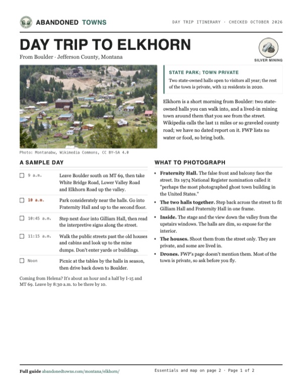
Around the park, Elkhorn is a scatter of old houses, cabins and sheds along a few dirt streets, some weathered and empty, others painted and lived in. A ruined timber mine building and pale mine dumps sit on the slope above. The cemetery, with the graves of the 1888 and 1889 epidemic, can be viewed. In a 2023 news story a local historian put it plainly: the town is private ground, not a ghost town where you can wander in and out. Stay on the streets.
The 1950 Clancy sheet in the historic maps below shows the town's grid on Elkhorn Creek ringed by mines, among them the Carmody, East Butte, Moreau, Heggen, Hardcash, Union and Golden Moss, with a cemetery south of town and a tramway road crossing Queen Gulch southeast of town. The 1976 Townsend sheet still names most of those mines.
- Fraternity Hall (1893), open
- Gilliam Hall, open
- Interpretive signs
- Private houses, cabins and sheds
- Ruined mine building and mine dumps
- Cemetery


Historic maps
Elkhorn on USGS maps, 1950–1976
Crops from the USGS Historical Topographic Map Collection, centered on the townsite. Each sheet shows what surveyors mapped that year; compare them with today's topo and aerial on this page.

Day trip
Plan a day trip to Elkhorn from Boulder
Take it with you
Day trip itinerary
The essentials, the sample day with boxes to tick, what to photograph and the coordinates, on two printable pages. Handy where there's no signal.
Download the PDF (631 KB)Elkhorn is a short morning from Boulder: two state-owned halls you can walk into, and a lived-in mining town around them that you see from the street. Wikipedia calls the last 11 miles or so graveled county road; we have no dated report on it. FWP lists no water or food, so bring both.
A sample day
- Leave Boulder south on MT 69, then take White Bridge Road, Lower Valley Road and Elkhorn Road up the valley.
- Park considerately near the halls. Go into Fraternity Hall and up to the second floor.
- Step next door into Gilliam Hall, then read the interpretive signs along the street.
- Walk the public streets past the old houses and cabins and look up to the mine dumps. Don't enter yards or buildings.
- Picnic at the tables by the halls in season, then drive back down to Boulder.
Coming from Helena? It's about an hour and a half by I-15 and MT 69. Leave by 8:30 a.m. to be there by 10.
What to photograph and film
- Fraternity Hall. The false front and balcony face the street. Its 1974 National Register nomination called it "perhaps the most photographed ghost town building in the United States."
- The two halls together. Step back across the street to fit Gilliam Hall and Fraternity Hall in one frame.
- Inside. The stage and the view down the valley from the upstairs windows. The halls are dim, so expose for the interior.
- The houses. Shoot them from the street only. They are private, and some are lived in.
- Drones. FWP's page doesn't mention them. Most of the town is private, so ask before you fly.
Map & directions
Getting there
Boulder is the closest town, under an hour away. From Helena, I-15 south brings you to the Boulder exit and the same road in. Both routes leave MT 69 south of Boulder for White Bridge Road, Lower Valley Road and Elkhorn Road, which climbs the valley to the town.


Base map: USGS The National Map (public domain). Routes: OSRM on © OpenStreetMap contributors data (ODbL), computed October 2026. Times assume dry roads.
- From West Centennial Avenue, turn right on South Main Street and follow MT 69 southeast.6.5 mi
- Turn left on White Bridge Road.0.3 mi
- Continue on Lower Valley Road, which becomes Elkhorn Road.2.8 mi
- Bear left to stay on Elkhorn Road up the valley.7.8 mi
- Continue on Main Street into Elkhorn to the state park halls.0.7 mi
- From West 6th Avenue, take Fuller Avenue, Lawrence Street, Warren Street and 11th Avenue (I-15 Business) east to the interstate.2.2 mi
- Merge onto I-15 south.26.8 mi
- Take exit 164 and turn left on MT 69.7.5 mi
- Turn left on White Bridge Road.0.3 mi
- Continue on Lower Valley Road, which becomes Elkhorn Road.2.8 mi
- Bear left to stay on Elkhorn Road up the valley.7.8 mi
- Continue on Main Street into Elkhorn to the state park halls.0.7 mi
Road and safety notes
- The routes are computed from OpenStreetMap and haven't been driven by us. Wikipedia describes the last 11 miles or so as graveled county roads; we have no dated report on their condition or on winter access.
- Elkhorn is private property outside the two state park halls, and people live there. Park considerately and stay off private land.
- No camping in or within walking distance of Elkhorn. Pack out your trash.
- At about 6,400 feet the town can get snow in winter. Summer is the usual season for a visit.
Photos
Elkhorn in photos
Visitor reports
Been to Elkhorn?
Been there lately? Tell the next visitor what you found: whether you could get in, the state of the road and what's still standing. Photos are welcome. We read every report before it appears here.
Silver mining
More silver mining ghost towns
The nearest in Montana, then the nearest elsewhere.

 Guide
Granite
46.32, -113.24Granite County, Montana
A silver town of about 3,000 people high on Granite Mountain, which emptied within a year of the 1893 crash. Montana's state parks keep the ruins of…
 Guide
Gilmore
44.46, -113.27Lemhi County, Idaho
A lead and silver town at the head of the Lemhi Valley that grew around the end of a Montana railroad, then emptied when the Depression closed its…
Nearby
Other sites near Elkhorn
Straight-line distance from the townsite to other mapped sites in our Montana index.
- Wickes9.1 mi NW · Jefferson
- Corbin9.2 mi NW · Jefferson
- Comet11.0 mi W · Jefferson
- Rimini20.6 mi NW · Lewis and Clark
- Louisville21.1 mi N · Jefferson
- Lombard28.6 mi SE · Broadwater
- Marysville37.0 mi NW · Lewis and Clark
- Maudlow38.7 mi E · Gallatin
Sources
Sources and credits
- Montana Fish, Wildlife & Parks, "Elkhorn State Park", read October 20, 2026: open all year, the two halls open to enter, the rest of town private, fees, address, phone, latrine and picnic tables, pack-out and no-camping rules, interpretive signs, and the Gilliam Hall spelling used in this guide (FWP writes Gilliam throughout).
- The Monitor (Jefferson County), "Elkhorn meets its ghost town fans", October 7, 2026: the October 4 tour, ongoing restoration, the preservation society's role, the saloon.
- KTVH, "Elkhorn, Montana: Not a ghost town, but a window to a resilient past and present", October 12, 2023: residents, private ground, the historian's warning, the park under an acre.
- Wikipedia, "Elkhorn, Montana", retrieved October 2026: coordinates, 1872, Holter, $14 million, 2,500 people, immigrant families, the epidemic, the railroad, the 1980 park, the 2020 census, the road description.
- Wikipedia, "Fraternity Hall", retrieved October 2026: the 1893 association, the building, its uses and lodges, the 1972 purchase, the 1975 listing, the nomination's "most photographed" line, the January 7, 1980 park.
- Legends of America, "Elkhorn, Montana Survives Today", updated August 2026: the 1870 discovery, 1875, the Elkhorn Mining Company, 1888 output, the 1889 sale and branch line, 600 people in 1893, the mine after 1900, 1931, the cemetery.
- ghosttowns.com, "Elkhorn": fact sheet fields (county, climate, best time).
- Photos: Wikimedia Commons, credited below each one; the 1963 photo is from the Historic American Buildings Survey, Library of Congress. Elevation: USGS 3D Elevation Program point query. Routes: OSRM on OpenStreetMap data, October 2026. Not field-checked.
- National Register of Historic Places nomination, "Fraternity Hall" (listed April 3, 1975), read October 21, 2026: the building description, and the 1972 purchase of Fraternity Hall and the hall beside it, which the form spells Gillian Hall.
- Montana Fish, Wildlife & Parks, Elkhorn State Park page above, read again October 21, 2026, for the day trip: no hours listed, the $4 walk-in fee, the seasonal latrine and picnic tables, phone; it lists no drinking water and says nothing about drones.
Photo and map credits
- Elkhorn from the hillside, with the mine dumps above, July 2015: Montanabw, Wikimedia Commons, CC BY-SA 4.0
- Gilliam Hall and Fraternity Hall, July 2017: Mark Holloway from Anaconda, Montana, Wikimedia Commons, CC BY 2.0
- Fraternity Hall and Gilliam Hall from the side, July 2015: Montanabw, Wikimedia Commons, CC BY-SA 4.0
- Fraternity Hall, September 1963: John N. DeHaas, Jr., Wikimedia Commons, Public domain
- The stage inside Fraternity Hall, July 2015: Montanabw, Wikimedia Commons, CC BY-SA 4.0
- Looking down the valley from the second floor of Fraternity Hall, July 2017: Mark Holloway from Anaconda, Montana, Wikimedia Commons, CC BY 2.0
- Houses along a dirt street, July 2015: Montanabw, Wikimedia Commons, CC BY-SA 4.0
- A ruined mine building above town, July 2015: Montanabw, Wikimedia Commons, CC BY-SA 4.0
- A weathered two-storey house among the pines, July 2015: Montanabw, Wikimedia Commons, CC BY-SA 4.0
- A headstone in the cemetery, July 2015: Montanabw, Wikimedia Commons, CC BY-SA 4.0
- Area base map, topo and aerial imagery: USGS The National Map (public domain).
- Historic maps: USGS Historical Topographic Map Collection (public domain): Clancy 1950, 1:62,500; Townsend 1976, 1:100,000.