 Abandoned

Overview
The bar is the town

Monowi sits on NE 12 in the hills above Ponca Creek in Boyd County, about seven miles from Lynch. It was platted in 1902, when the railroad reached the area, and got a post office the same year. By tradition the name means "flower" in a Native American language, for the wildflowers at the first townsite. The census counted 109 people in 1910 and 123 in 1930; Wikipedia's text puts the peak at about 150 in the 1930s.
After that the village drained away. The count fell to 67 in 1950 and 40 in 1960. The post office closed in 1967, and by 1990 six people were left. Rudy and Elsie Eiler, who had met at the town's one-room schoolhouse, bought the tavern in 1971. By 2000 they were Monowi's only residents, and when Rudy died in January 2004, Elsie was the last.
Monowi kept its charter. Eiler serves as mayor, clerk and treasurer, grants herself the tavern's liquor license and files the road plan that keeps state money coming for the village's four streetlights. She opened Rudy's Library in a small metal building across from the tavern with about 5,000 of her husband's books. Guinness World Records lists Monowi as the town with the lowest population, and in May 2025 repeated what she had told the New York Times: "The bar is the town, and I'm the town."
Video
Lunch at the Monowi Tavern
A travel couple detours to Monowi on a spring road trip in 2026. They stop at the population-one sign, then eat a cheeseburger at the Monowi Tavern, where Elsie Eiler is cooking. She tells them she and her husband bought the bar in 1971 and that the town once had a high school, a church and a couple of grocery stores. They sign the guest book, look through Rudy's Library and drive the streets past old, rundown houses. The second half of the video is Omaha and the drive home.
 Play “We Visited The SMALLEST TOWN In The USA! - Only 1 Resident!?” from YouTube
Timeline
From 123 people to one

- The railroad reaches the area and Monowi is platted. A post office opens the same year. By tradition the name means "flower" in a Native American language.
- The census counts 109 people.
- The census counts 123. Wikipedia's text puts the peak at about 150 in the 1930s.
- Down to 67. The USGS sheet that year still shows a grid of buildings beside the North Western railroad.
- The post office closes.
- Rudy and Elsie Eiler buy the tavern. Wikipedia says they reopened it in 1975; Guinness says the family has owned it since 1971.
- The census counts 18, then 6.
- Two residents: Rudy and Elsie Eiler.
- Rudy Eiler dies, leaving Elsie as Monowi's only resident. She becomes mayor.
- Elsie opens Rudy's Library with about 5,000 of his books. Wikipedia dates it to summer 2004; Guinness and Far & Wide say 2005.
- The census lists two people. The Census Bureau put the second one down to privacy noise added to the data, and Eiler said no one had moved in.
- Guinness World Records profiles Monowi as holder of the record for lowest population (town), with Eiler as mayor, clerk, treasurer, librarian and bartender.
- Far & Wide reports the tavern still open, with Eiler its sole resident.
What's left
Three buildings in use

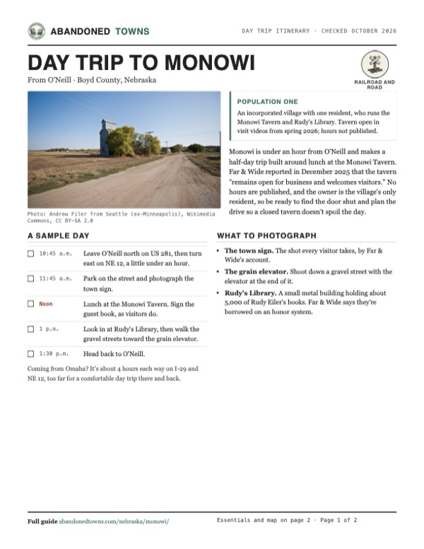
Guinness counted three buildings in use in 2025: the tavern, the library and Eiler's home. The 2010 census found three housing units, with only hers occupied. Around them are a few gravel streets, empty lots and leftover buildings. Photos from September 2012 show a wooden storefront leaning hard to one side, a house swallowed by trees, and a tall grain elevator at the edge of the fields. Visitors sign the tavern's guest book and photograph the town sign, Far & Wide reported in December 2025. Eiler's house is private.
The 1950 USGS sheet in the historic maps below draws Monowi as a dashed town boundary around a dozen-odd buildings, on the north side of the North Western railroad and Highway 12. The 1969 sheet shows it on the railroad near the Boyd–Knox county line, between the Missouri and Niobrara rivers, with Ponca Creek just east. On the 1986 sheet it is a name on NE 12 with almost nothing drawn around it.
- Monowi Tavern (open)
- Rudy's Library (2004 or 2005)
- Eiler's home (private)
- Empty houses and storefronts
- Grain elevator
- Gravel streets


Historic maps
Monowi on USGS maps, 1950–1986
Crops from the USGS Historical Topographic Map Collection, centered on the townsite. Each sheet shows what surveyors mapped that year; compare them with today's topo and aerial on this page.

Day trip
Plan a day trip to Monowi from O'Neill
Take it with you
Day trip itinerary
The essentials, the sample day with boxes to tick, what to photograph and the coordinates, on two printable pages. Handy where there's no signal.
Download the PDF (518 KB)Monowi is under an hour from O'Neill and makes a half-day trip built around lunch at the Monowi Tavern. Far & Wide reported in December 2025 that the tavern "remains open for business and welcomes visitors." No hours are published, and the owner is the village's only resident, so be ready to find the door shut and plan the drive so a closed tavern doesn't spoil the day.
A sample day
- Leave O'Neill north on US 281, then turn east on NE 12, a little under an hour.
- Park on the street and photograph the town sign.
- Lunch at the Monowi Tavern. Sign the guest book, as visitors do.
- Look in at Rudy's Library, then walk the gravel streets toward the grain elevator.
- Head back to O'Neill.
Coming from Omaha? It's about 4 hours each way on I-29 and NE 12, too far for a comfortable day trip there and back.
What to photograph and film
- The town sign. The shot every visitor takes, by Far & Wide's account.
- The grain elevator. Shoot down a gravel street with the elevator at the end of it.
- Rudy's Library. A small metal building holding about 5,000 of Rudy Eiler's books. Far & Wide says they're borrowed on an honor system.
Map & directions
Getting there
O'Neill is the nearest city, about 54 minutes away by US 281 and NE 12. From Omaha the drive runs up I-29 through Iowa and back into Nebraska on I-129, then west on NE 12. Both routes end on Brule Street in the village.


Base map: USGS The National Map (public domain). Routes: OSRM on © OpenStreetMap contributors data (ODbL), computed October 2026. Times assume dry roads.
- From downtown O'Neill, follow East Douglas Street (US 20 / US 275) and turn right onto North Harrison Street (US 281).1.3 mi
- Follow US 281 north.24.8 mi
- Turn right on 897th Road.2.6 mi
- At the end of the road, turn right onto NE 12.14.6 mi
- In the village, NE 12 becomes Grant Street. Turn left on Broad Street, then right onto Brule Street.0.4 mi
- From downtown Omaha, take 10th Street and Douglas Street onto I-480 / US 6 (Gerald R. Ford Expressway).2.1 mi
- Merge onto I-29 north.90.2 mi
- Exit onto US 75 Business, then merge onto I-129 / US 20 west.14.1 mi
- Turn right onto NE 12 (Highway 12) and follow it west, through Annie Street and 1st Street where it runs through towns.51.8 mi
- Stay on NE 12 west, through Harold Street, Walnut Street and East Main Street.46.0 mi
- In the village, NE 12 becomes Grant Street. Turn right on Broad Street, then right onto Brule Street.0.4 mi
Road and safety notes
- The routes are computed from OpenStreetMap and haven't been driven by us. We have no dated source on road surfaces.
- The tavern's hours aren't published anywhere we could find. Guinness (May 2025) says Eiler works six days a week, so a visit can still find the door shut.
- Eiler's house is a private home. Stay on the streets and in the tavern.
Photos
Monowi in photos
Visitor reports
Been to Monowi?
Been there lately? Tell the next visitor what you found: whether you could get in, the state of the road and what's still standing. Photos are welcome. We read every report before it appears here.
Railroad and road
More railroad, road and fort ghost towns
The nearest in Nebraska.

 Guide
Dobytown
40.64, -99.05Kearney County, Nebraska
Kearney City grew up in 1859 just outside Fort Kearny, selling whiskey, supplies and company to soldiers and travelers on the Platte River road.…
 Guide
Belmont
42.55, -103.36Dawes County, Nebraska
A tunnel camp on the Burlington line south of Crawford that became a small farm town. It peaked at about eighty people in the late 1920s and lost its…
Nearby
Other sites near Monowi
Straight-line distance from the townsite to other mapped sites in our Nebraska index.
Sources
Sources and credits
- ghosttowns.com, "Monowi": fact sheet fields (county, climate, best time).
- Wikipedia, "Monowi, Nebraska", retrieved October 2026: platting in 1902, the name, post office dates, census counts, the 1930s peak, the 2020 census noise, Eiler's offices, liquor license, road plan and streetlights, Rudy's Library, the 2010 housing units, the distance to Lynch, coordinates and GNIS elevation.
- Wikipedia, "Elsie Eiler", retrieved October 2026: her birth in 1933, the 1971 purchase and 1975 reopening of the tavern, Rudy's death in January 2004 and the library in summer 2004.
- Guinness World Records, "Inside the town with lowest population", May 20, 2025: the record, her offices, family ownership since 1971, 12 hours a day six days a week, three active buildings, the 2005 library, the schoolhouse, and the quotation.
- Far & Wide via AOL, "Meet the Woman Who Is the Mayor, Bartender, and Only Resident of Her Town", Dan Smith, December 18, 2025: the tavern open for business, the guest book, the 2005 library.
- Visit Nebraska, "Explore 7 Authentic Ghost Towns in Nebraska", undated, read October 2026: Monowi's population of one, and that it is sometimes called a ghost town itself.
- The Endless Adventure, "We Visited The SMALLEST TOWN In The USA! - Only 1 Resident!?", YouTube, uploaded May 17, 2026: the video on this page; the tavern open with Eiler cooking in spring 2026, the guest book, Rudy's Library.
- Jeremiah Staab, "I Visited The World's Smallest Town", YouTube, uploaded April 24, 2026: the tavern closed on the Monday he arrived and open, with Eiler cooking for a full room, the next day.
- Day trip: the Guinness and Far & Wide articles above, both read again October 21, 2026: the tavern open and welcoming visitors, simple meals and drinks, the 2024 prices, the six-day week, the guest book, the town sign and the library's honor system.
- Photos: Wikimedia Commons, credited below each one. Elevation: USGS 3D Elevation Program point query. Routes: OSRM on OpenStreetMap data, October 2026. Not field-checked.
Photo and map credits
- A gravel street toward the grain elevator, September 2012: Andrew Filer from Seattle (ex-Minneapolis), Wikimedia Commons, CC BY-SA 2.0
- Rudy's Library, March 2007: Bkell, Wikimedia Commons, Public domain
- A leaning wooden storefront beside a white building, September 2012: Andrew Filer from Seattle (ex-Minneapolis), Wikimedia Commons, CC BY-SA 2.0
- Rudy's Library across a gravel lot, September 2012: Andrew Filer from Seattle (ex-Minneapolis), Wikimedia Commons, CC BY-SA 2.0
- A house overgrown by trees beside a gravel street, September 2012: Andrew Filer from Seattle (ex-Minneapolis), Wikimedia Commons, CC BY-SA 2.0
- A gravel street in Monowi with a stop sign at the corner, September 2012: Andrew Filer from Seattle (ex-Minneapolis), Wikimedia Commons, CC BY-SA 2.0
- Inside the Monowi Tavern, August 2013: liumiao999, Wikimedia Commons, CC BY-SA 3.0
- Area base map, topo and aerial imagery: USGS The National Map (public domain).
- Historic maps: USGS Historical Topographic Map Collection (public domain): Monowi 1950, 1:24,000; ONeill 1969, 1:250,000; Atkinson 1986, 1:100,000.