 Abandoned

Overview
A gold rush that mined investors instead of ore

Meers sits in the foothills of the Wichita Mountains, about 22 miles northwest of Lawton, where OK 115 crosses Meers-Porter Hill Road. The Kiowa-Comanche-Apache reservation opened to settlers by lottery on August 6, 1901, and people who missed out on a homestead drifted into the mountains after old stories of Spanish gold. Camps named Wildman, Oreana, Doris, Golden Pass and Meers went up within months. Meers began in a cedar grove at the foot of Mount Sheridan and took the name of A. J. Meers, a mine operator who had worked the mountains since 1886.
That first site fell inside the forest and game reserve the government was fencing off, and late in 1902 the camp was ordered out. The tents and shacks moved a couple of miles north to the present crossroads. By 1903 the camp had hotels, cafes, stores, saloons, churches, a weekly newspaper and, by the 1976 National Register nomination's estimate, perhaps 3,000 people. The paper's headlines promised "the coming El Dorado of the world."
The same year a government geologist, H. Foster Bain, tested samples from 71 mines across the range and found nothing worth working. A 1962 review in the Proceedings of the Oklahoma Academy of Science reached the same verdict: no gold, silver, lead, copper or zinc in paying quantities. By 1907 the rush was over. A state historical marker sums it up: more mining of investors than of gold. The camp emptied almost as fast as it had filled, leaving a drugstore that became a general store, a post office, a gas station and a cafe, and is now a restaurant.
Timeline
Boom, bust and one survivor
- The Kiowa-Comanche-Apache reservation opens to settlement and prospectors pour into the Wichita Mountains. Iva Williams Allen remembered the Horne family camping by the big spring north of Mount Sheridan the day before, next to the McDaniels' cabin.
- Digging starts at the Gold Blossom mine. The camp in a cedar grove at the foot of Mount Sheridan takes the name of A. J. Meers, a mine operator whom the National Register nomination calls a Texas miner and Wikipedia places in Cherokee County, Georgia.
- A post office named Meers opens, by the date in Shirk's post office list. Allen remembered it being set up after the move to the present site, with Anna Kirk as postmistress.
- The government orders the camp out of the new forest and game reserve. Tents and shacks move a couple of miles north to the present site.
- The camp has hotels, cafes, stores, blacksmith shops, saloons and churches, and a population the 1976 nomination puts at "perhaps 3,000". The Mt. Sheridan Miner prints its first issue on October 24.
- Government geologist H. Foster Bain tests samples from 71 mines in the Wichitas and finds no values of importance.
- Forty tons of ore from the Snake Mine are run through Sam Remer's smelter southwest of Mount Sheridan. The smelter soon breaks down.
- The boom is over. Miners move on or take up farms and ranches on the newly opened land, and Meers shrinks as fast as it grew.
- A tornado and hailstorm strike the camp, wrecking houses southeast of it.
- The surviving store building is listed on the National Register of Historic Places as the Meers Mining Camp.
- The Oklahoma Geological Survey installs a seismograph in the store to watch the Meers Fault.
- The post office closes. Residents now use Lawton addresses.
A memoir
Life in the camp, 1901–1905
Most of what we know about daily life at Meers comes from Iva Williams Allen, who lived there from 1902 and wrote her memories for The Chronicles of Oklahoma in 1954. Her family pitched a tent between the two creeks after the move from the reservation, and their one-room house with a lean-to became the camp's meeting place. A Sunday school met there through the winter of 1902–03, a Cumberland Presbyterian church was organized under a brush arbor, and the camp's only organ was carried across the ravine each Sunday once services moved to a big tent.
She remembered the Fourth of July picnic of 1902 with barbecued beef, speeches, a greased-pig race and fiddlers; the Mt. Sheridan Miner, edited by Frank Davis, which printed a daily edition during the 1904 Sunday-school convention; a literary society that filled the tent on Saturday nights; mountain lions, bears and wolves in the hills; a bridge over Medicine Creek built in 1904 or 1905; and the tornado and hail of 1908.
She pushed back on the idea of a wild mining camp. Men drank, she wrote, but seldom to excess, and the years of greatest activity, 1901 to 1905, were respectable ones.
Her account of the mining is thinner, which is itself telling. She recalled the Minnie Lee prospect, backed by Kansas City money, the Mary Jane, Dr. Hardin's deep hole, and Sam Remer's small smelter, and a day when the Indian agent and police came to destroy machinery on an allotment and the miners talked them into leaving it for the courts.
What's left
The store, the cemetery and the fault

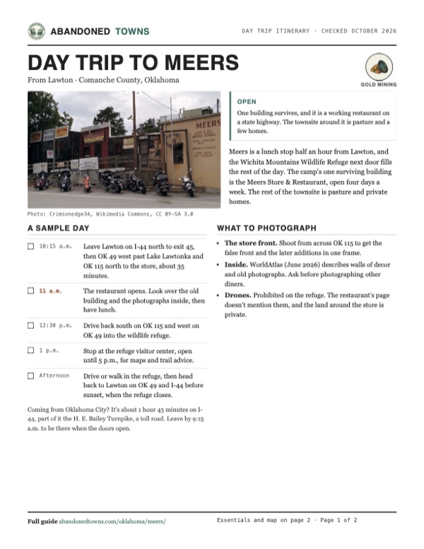
The Meers Store is the camp. The false-fronted south section probably dates from the 1902–03 boom, when it was a drugstore; the additions to the north came later. When Kent Ruth of the Oklahoma Historical Society nominated it in 1976, it held a few grocery staples, a branch post office, a gas pump and a small cafe already known for its hamburgers, with gold-rush artifacts and a photostat of the first Mt. Sheridan Miner on the walls. The nomination covered about an acre, because the rest of the camp had "long since disappeared." The National Register listed it on January 20, 1978.
Today the building is a restaurant with a stucco addition on the highway side. WorldAtlas wrote in June 2026 that the store "focuses on its restaurant above all else" and keeps original decor, old photographs and memorabilia inside. The two photos on this page, from 2014 and 2025, show the frame front with its painted signs and the yellow addition facing OK 115.
The 1956 USGS sheet marks Meers Cemetery on the section-line road a mile north of the store. Allen wrote that the first death in camp, in June 1903, led to burials on a hill nearby, in the northeast quarter of section 33. The original 1901 site, a couple of miles south at the foot of Mount Sheridan, is inside the Wichita Mountains Wildlife Refuge; the nomination says only scattered relics remained there, along with a pit believed to be an old Spanish arrastre just south of the present store. We haven't checked what survives.
Meers also gives its name to the Meers Fault. The Encyclopedia of Oklahoma History and Culture records that a very large earthquake about 1,200 to 1,300 years ago left a 16-mile fault scarp 15 feet high north of the present town, and in 1985 the Oklahoma Geological Survey put a seismograph in the store to watch it.
- Meers Store (drugstore, c. 1902–03, with later additions), now a restaurant
- Meers Cemetery, on the 1956 USGS sheet
- Original 1901 campsite inside the wildlife refuge (relics, per the 1976 nomination)
- Meers Fault scarp north of town


The historic maps below start with the 1950 Saddle Mountain sheet, which shows Meers, Meers School and Medicine Creek with Mount Sheridan to the south. The 1956 Meers sheet, the most detailed, shows a cluster of buildings at the crossroads, Jimmy Creek and a short track on the hill to the west. The 1956 Saddle Mountain sheet adds Meers Cemetery and Tarbone Mountain, and the 1981 Lawton sheet shows Mount Scott, Mount Wall and the edge of the lake to the east.
Historic maps
Meers on USGS maps, 1950–1981
Crops from the USGS Historical Topographic Map Collection, centered on the townsite. Each sheet shows what surveyors mapped that year; compare them with today's topo and aerial on this page.

Day trip
Plan a day trip to Meers from Lawton
Take it with you
Day trip itinerary
The essentials, the sample day with boxes to tick, what to photograph and the coordinates, on two printable pages. Handy where there's no signal.
Download the PDF (539 KB)Meers is a lunch stop half an hour from Lawton, and the Wichita Mountains Wildlife Refuge next door fills the rest of the day. The camp's one surviving building is the Meers Store & Restaurant, open four days a week. The rest of the townsite is pasture and private homes.
A sample day
- Leave Lawton on I-44 north to exit 45, then OK 49 west past Lake Lawtonka and OK 115 north to the store, about 35 minutes.
- The restaurant opens. Look over the old building and the photographs inside, then have lunch.
- Drive back south on OK 115 and west on OK 49 into the wildlife refuge.
- Stop at the refuge visitor center, open until 5 p.m., for maps and trail advice.
- Drive or walk in the refuge, then head back to Lawton on OK 49 and I-44 before sunset, when the refuge closes.
Coming from Oklahoma City? It's about 1 hour 45 minutes on I-44, part of it the H. E. Bailey Turnpike, a toll road. Leave by 9:15 a.m. to be there when the doors open.
What to photograph and film
- The store front. Shoot from across OK 115 to get the false front and the later additions in one frame.
- Inside. WorldAtlas (June 2026) describes walls of decor and old photographs. Ask before photographing other diners.
- Drones. Prohibited on the refuge. The restaurant's page doesn't mention them, and the land around the store is private.
Map & directions
Getting there
Lawton is the closest city, about half an hour away by I-44 and OK 49. From Oklahoma City the drive is the H. E. Bailey Turnpike to the same OK 49 exit. Both routes were computed from OpenStreetMap and haven't been driven by us.


Base map: USGS The National Map (public domain). Routes: OSRM on © OpenStreetMap contributors data (ODbL), computed October 2026. Times assume dry roads.
- From downtown Lawton, take West Gore Boulevard and Northwest 2nd Street (US 281 Business) to I-44.1.3 mi
- Follow I-44 (the Pioneer Expressway) north to exit 45.6.3 mi
- Turn left onto OK 49 and follow it west past Lake Lawtonka.10.7 mi
- Continue where OK 115 joins OK 49.0.7 mi
- Turn right onto Cache-Meers Road (OK 115) north. The store is at the junction with Meers-Porter Hill Road.3.4 mi
- From downtown Oklahoma City, take Reno Avenue and Oklahoma City Boulevard to I-40 west.2.7 mi
- Follow I-40 west briefly to exit 147A for I-44.1.1 mi
- Take I-44 south, which becomes the H. E. Bailey Turnpike, to exit 49.74.3 mi
- Turn right onto OK 49 and follow it west past Lake Lawtonka.10.6 mi
- Continue where OK 115 joins OK 49, then turn right onto Cache-Meers Road (OK 115) north to the store.4.1 mi
Road and safety notes
- The whole route is on interstate and state highways. An undated listing rates the roads 2WD, and the 2025 photo shows pavement at the store.
- The restaurant posts its hours on Facebook. From October 1, 2026 it gives Thursday to Saturday, 11 a.m. to 4 p.m., and Sunday, 11 a.m. to 3 p.m. (post of September 26, 2026, checked October 21). Call before a long drive.
- The H. E. Bailey Turnpike is a toll road.
- The original campsite is inside the Wichita Mountains Wildlife Refuge. Refuge rules apply there; don't dig or collect.
Photos
Meers in photos
Visitor reports
Been to Meers?
Been there lately? Tell the next visitor what you found: whether you could get in, the state of the road and what's still standing. Photos are welcome. We read every report before it appears here.
Gold mining
More gold mining ghost towns
The nearest, in other states.

 Guide
Elizabethtown
36.62, -105.28Colfax County, New Mexico
E-town rose after the 1866 gold discoveries and briefly became Colfax County’s seat. Stone walls and a cemetery outlasted the mining town.
 Guide
White Oaks
33.75, -105.74Lincoln County, New Mexico
A gold town of a few thousand people that refused the railroad's terms and lost it to Carrizozo. A few residents remain among its brick and stone…
Nearby
Other sites near Meers
Straight-line distance from the townsite to other mapped sites in our Oklahoma index.
Sources
Sources and credits
- National Register of Historic Places nomination, "Meers Mining Camp" (Kent Ruth, Oklahoma Historical Society, 1976; listed January 20, 1978): reservation opening, Gold Blossom mine, A. J. Meers, the 1902 move, the 1903 camp and its population estimate, the Mt. Sheridan Miner, the end by 1907, the store building and what it held in 1976, the original site and arrastre pit.
- Iva Williams Allen, "Early Days in Meers," The Chronicles of Oklahoma 32, no. 3 (1954), pp. 278–289: the first families in August 1901, the move late in 1902, the post office and postmistress, camp life, the newspaper, the first burials, the 1908 tornado and the years of greatest activity.
- Steve Wilson, "Economic Possibilities of Mining in the Wichita Mountains," Proceedings of the Oklahoma Academy of Science for 1962, pp. 160–163: the August 6, 1901 opening, the camps, the six smelters, the Remer smelter and the Snake Mine ore, Bain's 1903 tests of 71 mines, and the finding of no paying minerals.
- Wikipedia, "Meers, Oklahoma", retrieved October 2026: founding year, the namesake's Georgia origin, post office dates, Lawton addresses, the 1985 seismograph, coordinates and elevation (GNIS).
- Kenneth V. Luza, "Earthquakes," The Encyclopedia of Oklahoma History and Culture: the Meers Fault scarp.
- "Oklahoma's Gold Rush" marker, Oklahoma History Center, via the Historical Marker Database: 2,000 to 3,000 miners, little gold produced.
- WorldAtlas, "9 Old-Timey General Stores in Oklahoma" (June 3, 2026): the store open as a restaurant, its earlier uses, decor and photographs.
- ghosttowns.com, "Meers": fact-sheet fields (county, roads, climate, best time, remains).
- Commons file pages for each photo: dates and camera locations. Elevation: USGS 3D Elevation Program point query. Routes: OSRM on OpenStreetMap data, October 2026. Not field-checked.
- Meers Store and Restaurant, Facebook page, read in the browser October 21, 2026: the September 26, 2026 post with hours from October 1 (still the newest post on the page that day), the menu items it names, address and phone.
- U.S. Fish and Wildlife Service, Wichita Mountains Wildlife Refuge, "Visit Us", read October 21, 2026: refuge and visitor center hours, no entry charge, the drone ban, directions on OK 49.
Photo and map credits
- The store front from the highway shoulder, September 2014: Crimsonedge34, Wikimedia Commons, CC BY-SA 3.0
- The store from across OK 115, March 2025: TulGuy, Wikimedia Commons, CC0
- Meers-Porter Hill Road looking west toward Meers in summer (posted 2010): jonathan c. wheeler, Wikimedia Commons, CC BY-SA 3.0
- Area base map, topo and aerial imagery: USGS The National Map (public domain).
- Historic maps: USGS Historical Topographic Map Collection (public domain): Saddle Mountain 1950, 1:62,500; Meers 1956, 1:24,000; Saddle Mountain 1956, 1:62,500; Lawton 1981, 1:100,000.