 Abandoned

Overview
The town that fell into the sea

Thomas Irving Potter came across the spit that forms the west wall of Tillamook Bay while sightseeing and hunting on the coast. In 1906 he and his father, Thomas Benton Potter, began building a resort there and billed it as the Atlantic City of the West. The name joins the bay and the ocean it looks out on.
Bayocean had a hotel with an orchestra, a dance hall, a 1,000-seat movie theater, a bowling alley, tennis courts and four miles of paved streets. Its natatorium was a heated pool with a wave generator. A post office opened in 1909, and the population was 2,000 by 1914. Until the 1920s there was no road in, and most visitors came on the Potters' steamship.
The rough crossing into the bay led residents to ask for a jetty. The Army Corps of Engineers proposed two, one on each side of the bay mouth, for about $2.2 million. Residents had only one built, for a little over $800,000, and Wikipedia traces the erosion of the beaches to that one-sided change. Storm waves wrecked the natatorium in 1932, and storms in 1939, 1942 and 1948 broke up the spit. By 1952 what was left was an island. A 1956 dike and reclamation project demolished the rest, the last house washed away in 1960, and the last building, a garage, fell into the ocean in 1971.
Timeline
Bayocean through the years

- Thomas Irving Potter and his father, Thomas Benton Potter, found a resort town on Tillamook Spit.
- A post office opens on February 4.
- The population reaches 2,000.
- A road finally connects the town to the rest of the country. Before that, most people came by the Potters' steamship.
- Storm waves cross the beach and destroy the natatorium.
- Winter storms in 1939, 1942 and 1948 break up the spit.
- What's left of Bayocean has become an island.
- The post office closes.
- A reclamation and dike-building project demolishes the rest of the town.
- The last house washes away.
- The last building, a garage, falls into the ocean.
- A second jetty is built, and sand begins to build the spit back up.
What's left
Sand where the town stood

A second jetty in the 1970s let sand build up again, and the spit is now the Bayocean Peninsula day-use area, which the county lists as a historical and heritage area and wildlife preserve. Virtually nothing of the town survives. Wikipedia says a commemorative sign stands at the south end of the park, and a sandy 7.8-mile loop trail around the peninsula starts and ends at the parking lot.
The historic maps below do the most work here. The 1937 Nehalem sheet shows the town's streets along the spit, with Pitcher Point to the south. On the 1955 sheet the spit is cut off from Pitcher Point, and only a few streets remain. By 1979 Bayocean is a single dot, and a dike runs from Pitcher Point up to the spit.
- Commemorative sign at the south end of the park
- 7.8-mile sandy loop trail around the peninsula


Historic maps
Bayocean on USGS maps, 1937–1979
Crops from the USGS Historical Topographic Map Collection, centered on the townsite. Each sheet shows what surveyors mapped that year; compare them with today's topo and aerial on this page.

Day trip
Plan a day trip to Bayocean from Tillamook
Take it with you
Day trip itinerary
The essentials, the sample day with boxes to tick, what to photograph and the coordinates, on two printable pages. Handy where there's no signal.
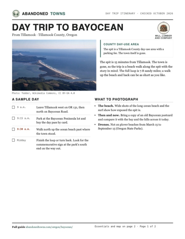
Download the PDF (427 KB)The spit is 15 minutes from Tillamook. The town is gone, so the trip is a beach walk along the spit with the story in mind. The full loop is 7.8 sandy miles; a walk up the beach and back can be as short as you like.
A sample day
- Leave Tillamook west on OR 131, then north on Bayocean Road.
- Park at the Bayocean Peninsula lot and buy the day pass by card.
- Walk north up the ocean beach past where the town stood.
- Finish the loop or turn back. Look for the commemorative sign at the park's south end on the way out.
What to photograph and film
- The beach. Wide shots of the long ocean beach and the surf show how exposed the spit is.
- Then and now. Bring a copy of an old Bayocean postcard and compare it with the bay and the hills across it today.
- Drones. Not on plover beaches from March 15 to September 15 (Oregon State Parks).
Map & directions
Getting there
From Tillamook, head west on OR 131 and turn north on Bayocean Road along the south end of Tillamook Bay, then take Bayocean Dike Road out to the spit. From Portland, take US 26 and OR 6, the Wilson River Highway, to Tillamook. The routes stop on Bayocean Dike Road, about half a mile south of the mapped townsite; the rest is on foot.


Base map: USGS The National Map (public domain). Routes: OSRM on © OpenStreetMap contributors data (ODbL), computed October 2026. Times assume dry roads.
- From downtown, take 4th Street and Stillwell Avenue to 3rd Street, OR 131, and head west onto the Netarts Highway.1.8 mi
- Turn right onto Bayocean Road Northwest.5.0 mi
- Turn right onto Bayocean Dike Road.0.9 mi
- From downtown, take Southwest Broadway and Clay Street to the Sunset Highway, US 26 west.21.5 mi
- Take the Wilson River Highway, OR 6, to Tillamook.51.0 mi
- In Tillamook, follow Main Avenue and 3rd Street, OR 131, west.1.9 mi
- Turn right on Bayocean Road Northwest, then right on Bayocean Dike Road.6.0 mi
Road and safety notes
- An undated listing rates the road 2WD. The routes stop on Bayocean Dike Road; the mapped townsite is about half a mile farther north on foot.
- From March 15 to September 15, Oregon State Parks bars dogs (even on a leash), bikes, vehicles, kites, drones and camping from designated plover beaches, and walkers must stay on the wet, hard-packed sand. Its North Coast plover map lists Bayocean Spit as one of those areas.
- Day-use areas other than campgrounds close at 10 p.m. (Tillamook County).
Photos
Bayocean in photos
Visitor reports
Been to Bayocean?
Been there lately? Tell the next visitor what you found: whether you could get in, the state of the road and what's still standing. Photos are welcome. We read every report before it appears here.
Mill, lumber and company
More mill, lumber and company ghost towns
The nearest, in other states.

 Guide
Allah
33.93, -112.69Maricopa County, Arizona
A pioneer ranch on a desert river that became the Garden of Allah resort, with its own train stop and post office. The grounds are now a nature…
 Guide
Sundad
33.18, -113.24Maricopa County, Arizona
A desert health colony from the 1920s that never took off. What's left is a scatter of foundations on federal land, and its name spelled out in rocks…
Nearby
Other sites near Bayocean
Straight-line distance from the townsite to other mapped sites in our Oregon index.
- Hobsonville2.8 mi NE · Tillamook
- Brighton10.1 mi N · Tillamook
- Idiotville26.6 mi E · Tillamook
- Necanicum27.4 mi N · Clatsop
- Thatcher39.3 mi E · Washington
- Kernville43.5 mi S · Lincoln
- Saint Joseph44.0 mi SE · Yamhill
- Ballston44.2 mi SE · Polk
Sources
Sources and credits
- ghosttowns.com, "Bayocean": fact sheet fields (road, climate, best time, remains).
- Wikipedia, "Bayocean, Oregon", retrieved October 2026: founders, founding, name, amenities, population, post office dates, steamship, jetty costs, storms, island by 1952, demolition, last house and garage, second jetty, commemorative sign, loop trail.
- Tillamook County Parks Department, "Day Use Areas", official site, read October 19, 2026: Bayocean Peninsula listing and activities, $10 single-day pass, credit card only at Bayocean, 2026 annual passes; and its fee program page: day-use closing times.
- Oregon Parks and Recreation, western snowy plover page, read October 2026, and its North Coast plover map: March 15 to September 15 season, rules on dogs, bikes, vehicles, kites, drones, camping and wet sand, Bayocean Spit as a management area.
- Oregon Parks and Recreation and Siuslaw National Forest news release, March 11, 2026: the 2026 nesting season and rules.
- Coordinates: Wikipedia (from USGS GNIS). Elevation: USGS 3D Elevation Program point query. Routes: OSRM on OpenStreetMap data, October 2026.
Photo and map credits
- A crowd by the beach railroad, July 4, 1910: H. R. Gregg, Bay City, Ore., Wikimedia Commons, Public domain
- On a hotel terrace, about 1911 to 1914: Unknown author, Wikimedia Commons, Public domain
- The Bayocean spit from the air, June 2022: Tedder, Wikimedia Commons, CC BY-SA 4.0
- The natatorium and dance hall, about 1911 to 1914: Unknown author, Wikimedia Commons, Public domain
- Topo map, area base map and aerial imagery: USGS The National Map (public domain).
- Historic maps: USGS Historical Topographic Map Collection (public domain): Nehalem 1937, 1:62,500; Nehalem 1955, 1:62,500; Nehalem River 1979, 1:100,000.