 Abandoned

Overview
A gold camp that never quite emptied
In August 1876 three hunters from Deadwood found gold-bearing rock on Montezuma Hill, above Little Rapid Creek. Placer miners came over from Lead and Central City. One of the finders, M. D. Rochford, built the first cabin in February 1877, and in May 1878 he and Richard Hughes laid out a town in the gulch.
The boom was quick. By December 1878 Rochford had about 500 residents and as many prospectors camped on the surrounding hills. By January 1879 it had two hotels, a theater and a drugstore, and Lawrence County paid $300 for a road to Deadwood, whose merchants wanted Rochford's trade to come their way rather than go to Rapid City. The Standby mine and its stamp mill drove the growth, but the mill closed in 1881 and ran only fitfully afterward. The 1880 census found 315 people; by 1900 there were 48.
Rochford never fully emptied. The railroad arrived in 1889, and its tracks stayed until 1985–1986. By the 1950s only the Moonshine Gulch Saloon, the Irish Gulch Dance Hall and one store were open. The saloon still is. It dates its building to 1910, the first record of it, and it is the town's draw for passing travelers.
Timeline
Boom and long decline
- Three hunters from Deadwood, M. D. Rochford, Richard B. Hughes and William Van Fleet, find gold-bearing rock on Montezuma Hill.
- Rochford builds the first cabin on the future townsite.
- A mining district is organized.
- Rochford, then a county commissioner, and Hughes lay out the town in a gulch near Rapid Creek. Lots sell for $10 to $60.
- About 500 residents, with as many prospectors camped on the hills. The town has three saloons, six stores and a Methodist Episcopal church.
- Two hotels, a theater, two restaurants, two blacksmiths and a drugstore have opened. Lawrence County pays $300 for a road to Deadwood.
- The census counts 315 people. The Standby mill runs 60 stamps by May but closes in 1881, then works on and off until 1936.
- The railroad reaches Rochford. Its tracks come up in 1985–1986.
- 48 residents and a post office.
- Only the Moonshine Gulch Saloon, the Irish Gulch Dance Hall and one store are open.
- The Standby mill is demolished.
What's left
What you'll see
Legends of America says Rochford still has several historic buildings, though it gives no count. The Moonshine Gulch Saloon is the one everyone stops for. The Standby mill and its office, nicknamed "The Mansion," are gone: the office before 1950, the mill in 1987. Wikipedia names Montezuma and Golden Centre among the other camps nearby, and Myers City to the southwest. The 1901 and 1916 sheets in the historic maps below mark it as Myersville, and the 1956 sheet shows the Standby Mine east of town.
- Moonshine Gulch Saloon
- Historic buildings
- A few homes
- Mine sites in the surrounding hills


Historic maps
Rochford on USGS maps, 1894–1956
Crops from the USGS Historical Topographic Map Collection, centered on the townsite. Each sheet shows what surveyors mapped that year; compare them with today's topo and aerial on this page.

Day trip
Plan a day trip to Rochford from Hill City
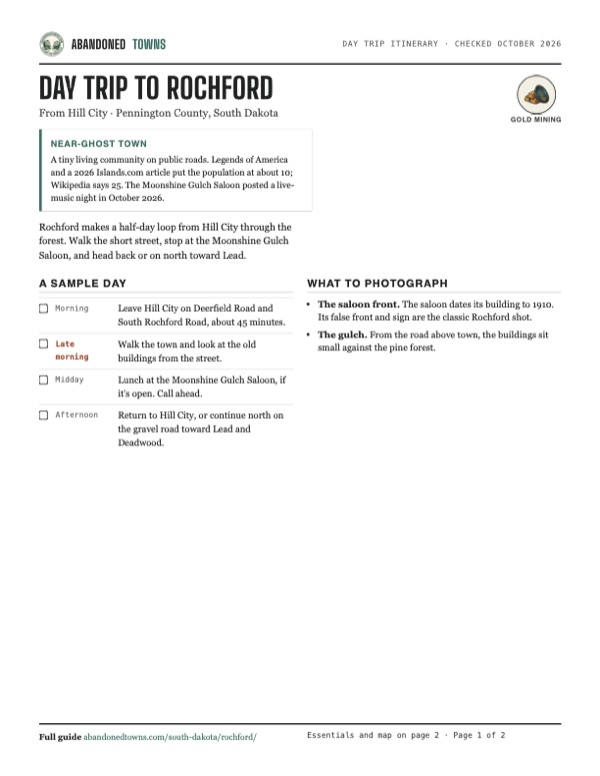
Take it with you
Day trip itinerary
The essentials, the sample day with boxes to tick, what to photograph and the coordinates, on two printable pages. Handy where there's no signal.
Download the PDF (434 KB)Rochford makes a half-day loop from Hill City through the forest. Walk the short street, stop at the Moonshine Gulch Saloon, and head back or on north toward Lead.
A sample day
- Leave Hill City on Deerfield Road and South Rochford Road, about 45 minutes.
- Walk the town and look at the old buildings from the street.
- Lunch at the Moonshine Gulch Saloon, if it's open. Call ahead.
- Return to Hill City, or continue north on the gravel road toward Lead and Deadwood.
What to photograph and film
- The saloon front. The saloon dates its building to 1910. Its false front and sign are the classic Rochford shot.
- The gulch. From the road above town, the buildings sit small against the pine forest.
Map & directions
Getting there
Rochford is reached on back roads through the national forest. From Hill City, Deerfield Road and South Rochford Road run north to the town. From Rapid City, the route goes west on SD 44, north on US 385 and in on Rochford Road.


Base map: USGS The National Map (public domain). Routes: OSRM on © OpenStreetMap contributors data (ODbL), computed October 2026. Times assume dry roads.
- From Main Street in Hill City, turn left on Deerfield Road.17.8 mi
- Continue straight on South Rochford Road.11.3 mi
- At the end of the road, turn right on Rochford Road (FSR 231) into town.0.7 mi
- From downtown Rapid City, follow Main Street west onto Jackson Boulevard.4.4 mi
- Continue on SD 44 west.13.5 mi
- Turn right on US 385 north.4.4 mi
- Turn left on Rochford Road (FSR 237) to Rochford.11.7 mi
Road and safety notes
- Wikipedia and Legends of America describe the road through Rochford to Mystic, Lead and Deadwood as gravel.
- These are mountain roads through the Black Hills National Forest. Allow extra time, and check winter conditions before you go.
Photos
Have photos of Rochford?
We haven’t added photographs of Rochford yet. If you’ve visited, share your photos and a field report below.
Visitor reports
Been to Rochford?
Been there lately? Tell the next visitor what you found: whether you could get in, the state of the road and what's still standing. Photos are welcome. We read every report before it appears here.
Gold mining
More gold mining ghost towns
The nearest in South Dakota.

 Guide
Terry
44.33, -103.82Lawrence County, South Dakota
A gold-mining town of nearly 1,200 people below Terry Peak, where Calamity Jane died in 1903. SDPB reported in 2018 that the townsite is private land…
 Guide
Rockerville
43.96, -103.36Pennington County, South Dakota
A gold camp of 1876 named for the hand rockers its miners used. It had a second life as a tourist stop on the road to Mount Rushmore, until the…
Nearby
Other sites near Rochford
Straight-line distance from the townsite to other mapped sites in our South Dakota index.
- Myers City1.7 mi SW · Pennington
- Nahant4.0 mi NW · Lawrence
- Mystic5.1 mi SE · Pennington
- Merritt7.6 mi E · Pennington
- Silver City8.2 mi E · Pennington
- Redfern9.2 mi SE · Pennington
- Greenwood10.3 mi NE · Lawrence
- Novak10.5 mi NE · Lawrence
Sources
Sources and credits
- Wikipedia, "Rochford, South Dakota", retrieved October 2026: discovery, founding, mines and mills, 1878–1880 growth, population figures, the 1950s, location.
- Legends of America, "Rochford, South Dakota", updated November 2025: the three finders, Montezuma Hill, the prospectors on the hills, the railroad dates, the 1987 mill demolition, the gravel road, a population of about 10, several historic buildings.
- Moonshine Gulch Saloon, "About", read October 2026: the 1910 first record of the building, the Mickelson Trail trailhead nearby. No hours posted.
- Moonshine Gulch Saloon on Facebook, read October 19, 2026: phone number, a live-music post dated October 13, 2026.
- Pigeon605, "Historic Black Hills saloon brings new additions for season ahead", June 10, 2024 (sponsored): seating and first-come policy, from the general manager.
- Islands.com, April 22, 2026: a population of about 10.
- ghosttowns.com, "Rochford": fact-sheet fields (best time).
- Elevation: USGS 3D Elevation Program point query. Routes: OSRM on OpenStreetMap data, October 2026.
Photo and map credits
- Topo map, area base map and aerial imagery: USGS The National Map (public domain).
- Historic maps: USGS Historical Topographic Map Collection (public domain): Deadwood 1894, 1:125,000; Deadwood 1901, 1:125,000; Deadwood 1916, 1:125,000; Rochford 1956, 1:24,000.