 Abandoned
Overview
The town that went up for auction

Albert sits on Williams Creek in the southeast corner of Gillespie County, a mile from the Blanco County line. It began in 1877 as Martinsburg, a stop on the stage road between Fredericksburg and Blanco. In 1892 Albert Luckenbach sold his store in the town that carries his family name, moved here and opened a post office under his own first name.
The town never got big. It had a school, a store, a singing society and a dance hall, and a young Lyndon Johnson spent a year at its school. There were 50 people in 1925 and four in 1964. By 1985 the store had been torn down and the dance hall was being used for storage.
Then the town got a second life. Bobby Cave bought the property in 2004 and built a tavern where the store had stood. In October 2007 he listed the whole town on eBay with a $2.5 million reserve. In 2009 it was divided up and offered for sale again, and the Easley family's company bought a 12.09-acre piece. Today the Albert Icehouse & Dancehall runs a beer garden with free shows Wednesday to Sunday, and ticketed shows in the dance hall.
Timeline
From Martinsburg to eBay

- Fritz Wilke, George Maenius and John Petri move out from Fredericksburg looking for grazing land. The settlement is called Martinsburg, a stop on the Fredericksburg–Blanco stage route.
- The Martinsburg post office operates. After 1886 the mail goes through Hye in Blanco County.
- The first local school opens.
- Albert Luckenbach sells his store in Luckenbach, moves here and opens a new post office, which he registers as Albert.
- Postmaster Otto Schumann opens the town's first store. The Albert Echo singing society follows in 1898.
- A new school building goes up. Young Lyndon Johnson is enrolled there for a year.
- Albert has 50 residents. By 1964 the count is four.
- The store has been torn down, the school is a community club and the dance hall is partitioned for storage.
- Bobby Cave buys the property for $216,000 and builds a tavern on the site of the old store.
- Cave lists the town on eBay with a $2.5 million reserve.
- The town is divided up and offered for sale again. A 12.09-acre parcel later goes to the Easley family's company, and Brandon Easley, named town manager, fixes up what is now the Albert Ice House and Dance Hall.
What's left
What you'll see
The dance hall is the reason to come. The icehouse beside it has a patio and beer garden. The Handbook of Texas noted in 1985 that the old school had become a community club. Everything else around the crossroads is private ranch land, so stay on the venue grounds.
- Dance hall
- Icehouse and beer garden
- Old school building
- Williams Creek crossing


Historic maps
Albert on USGS maps, 1894–1985
Crops from the USGS Historical Topographic Map Collection, centered on the townsite. Each sheet shows what surveyors mapped that year; compare them with today's topo and aerial on this page.
Day trip
Plan a day trip to Albert from Fredericksburg
Take it with you
Day trip itinerary
The essentials, the sample day with boxes to tick, what to photograph and the coordinates, on two printable pages. Handy where there's no signal.
Download the PDF (484 KB)Albert is an afternoon and evening more than a day. Spend the day in the Hill Country and finish at the beer garden when the music starts. Luckenbach, where Albert Luckenbach kept store before he moved here, is about 20 miles west by road, also just south of US 290, so the two old dance-hall towns pair well.
A sample day
- Leave Fredericksburg on US 290 east and stop at Luckenbach first, on RM 1376 south of the highway.
- Drive on to Albert. Straight from Fredericksburg it is about half an hour.
- Stay for the beer garden and whatever band is on. On Thursday to Sunday the food vendor serves until 8 p.m.
What to photograph and film
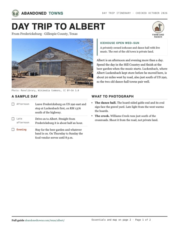
- The dance hall. The board-sided gable end and its oval sign face the gravel yard. Late light from the west warms the boards.
- The creek. Williams Creek runs just south of the crossroads. Shoot it from the road, not private land.
Map & directions
Getting there
Fredericksburg is the closest city, about half an hour east on US 290 and south on RM 1623. From San Antonio, the route runs up US 281 to Johnson City and west on RM 1623. Both are paved all the way.


Base map: USGS The National Map (public domain). Routes: OSRM on © OpenStreetMap contributors data (ODbL), computed October 2026. Times assume dry roads.
- Head east on East Main Street (US 87/US 290) out of downtown Fredericksburg.2.4 mi
- Continue east on US 290.12.7 mi
- Turn right on RM 1623 and follow it south to Albert.5.4 mi
- From downtown San Antonio, take Market Street east and join I-37/US 281 north.2.1 mi
- Follow US 281 (McAllister Freeway) north into Johnson City.47.8 mi
- Turn left on 4th Street (RM 1623) and follow RM 1623 west to Albert.14.5 mi
Road and safety notes
- Paved all the way. RM 1623 is a narrow two-lane ranch road; watch for deer at dusk.
- The land around the dance hall is private. Park and stay on the venue grounds.
Photos
Albert in photos
Visitor reports
Been to Albert?
Been there lately? Tell the next visitor what you found: whether you could get in, the state of the road and what's still standing. Photos are welcome. We read every report before it appears here.
Farm and ranch
More farm and ranch ghost towns
The nearest in Texas.

 Guide
Luckenbach
30.18, -98.76Gillespie County, Texas
A German farm hamlet of 492 people in 1904 that had nearly emptied by the 1960s. Hondo Crouch bought it in 1971, and a hit song made it famous.…
 Guide
Morris Ranch
30.22, -99.01Gillespie County, Texas
A town built around a big thoroughbred operation. The horses left in 1902, the post office in 1954, and the stone schoolhouse now stands on a private…
Nearby
Other sites near Albert
Straight-line distance from the townsite to other mapped sites in our Texas index.
- Nebgen School8.6 mi N · Gillespie
- Luckenbach9.3 mi W · Gillespie
- Grapetown10.5 mi W · Gillespie
- Cain City12.6 mi W · Gillespie
- Bankersmith13.5 mi W · Kendall
- Fort Martin Scott15.1 mi W · Gillespie
- Currey's Creek15.5 mi S · Kendall
- Eckert17.2 mi NW · Gillespie
Sources
Sources and credits
- Handbook of Texas Online, "Albert, TX" (Martin Donell Kohout, rev. 1994), accessed October 19, 2026: founding, Martinsburg name, post office dates, school and LBJ, population figures, 1985 condition.
- Wikipedia, "Albert, Texas", retrieved October 2026: 2004 purchase, 2007 eBay listing, 2009 division and resale, the Easley parcel.
- Albert Icehouse & Dancehall, official site, and its Icehouse page, as of October 2026: hours, address, beer garden, free and ticketed shows, food vendor, the move from Luckenbach about 20 miles away.
- Elevation: USGS 3D Elevation Program point query. Routes: OSRM on OpenStreetMap data, October 2026.
Photo and map credits
- The Albert Dance Hall, 2012: Renelibrary, Wikimedia Commons, CC BY-SA 3.0
- The 1961 Hye sheet: U.S. Geological Survey, USGS catalog, Public domain
- The 1894 Fredericksburg sheet still labels the town Martinsburgh, on Williams Creek east of Stonewall: U.S. Geological Survey, USGS catalog, Public domain
- Area base map, topo and aerial imagery: USGS The National Map (public domain).
- Historic maps: USGS Historical Topographic Map Collection (public domain): Fredericksburg 1894, 1:125,000; Llano 1954, 1:250,000; Hye 1961, 1:24,000; Pedernales River 1985, 1:100,000.