 Abandoned

Overview
The town Baylor left

Independence sits where Farm Roads 50 and 390 meet, about 12 miles northeast of Brenham. John P. Coles, one of Stephen F. Austin's Old Three Hundred, settled here in the 1820s, and the place was first called Coles' Settlement. A town was laid out in 1835 and took the name Independence around 1836. Sources disagree on exactly when and who named it.
It became a church and school town. Independence Baptist Church was organized in 1839, and Sam Houston was baptized into it in 1854. In 1845 the town won the new Baptist university, and Baylor opened in 1846 with 24 pupils. It later split into Baylor University and Baylor Female College.
In 1885 both colleges left, the university for Waco and the women's college for Belton. The Handbook of Texas calls that the start of a century-long decline. Baylor's own museum and the state markers date the move to 1886. The town had 140 people in 1990 and 2000, among the ruins and markers of the college town.
Timeline
From Coles' Settlement to Baylor and back

- John P. Coles, one of Stephen F. Austin's Old Three Hundred colonists, brings his family to Texas and receives a Mexican land grant here. The place becomes Coles' Settlement.
- Four settlers lay out a town on 78 acres. Frances Trask opens a girls' boarding school.
- The settlement takes the name Independence. The 1997 state marker tells, as local legend, of Dr. Asa Hoxey proposing the name while celebrating the Declaration of Independence, and notes that county records show the town began in 1835.
- Independence Baptist Church is organized.
- Independence wins the new Baptist university. Baylor opens in 1846 with 24 pupils. A post office opens the same year.
- The town is incorporated.
- Sam Houston is baptized and joins Independence Baptist Church.
- The two departments become Baylor University and Baylor Female College.
- Baylor University moves to Waco and the women's college to Belton. The Handbook of Texas gives 1885; Baylor's museum and the state markers give 1886. A century of decline begins.
- About 200 people; the post office has closed.
- 140 people.
- The site of Baylor's Windmill Hill campus goes on the National Register of Historic Places.
What's here
Columns, a church and a museum


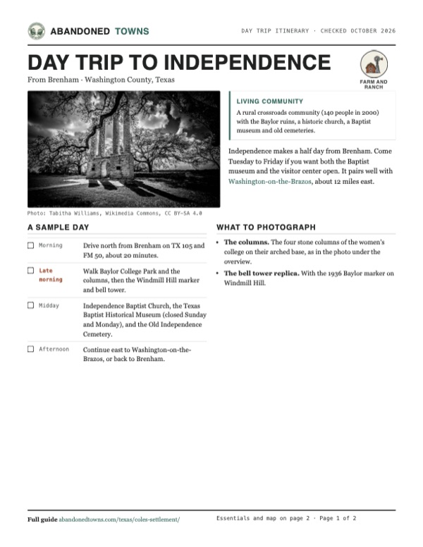
Old Baylor Park, run jointly by Baylor University and the University of Mary Hardin-Baylor, holds the four columns of Baylor Female College. The men's campus stood on Windmill Hill, where only rough outlines of its buildings remain, along with a 1936 marker and a replica bell tower; the site went on the National Register in 2024. Independence Baptist Church and the Texas Baptist Historical Museum are in town, along with Judge Coles's home. Old Independence Cemetery holds Judge Coles, Sam Houston Jr., Moses Austin Bryan and the first mayor, T. T. Clay. The Margaret Houston House and the Houston-Lea Family Cemetery, where Sam Houston's widow is buried, are nearby.
- Columns of Baylor Female College (Baylor College Park)
- Baylor University on Windmill Hill marker and replica bell tower
- Independence Baptist Church
- Texas Baptist Historical Center
- Judge Coles's home
- Old Independence Cemetery
- Margaret Houston House and Houston-Lea Family Cemetery


Historic maps
Independence on USGS maps, 1914–1993
Crops from the USGS Historical Topographic Map Collection, centered on the townsite. Each sheet shows what surveyors mapped that year; compare them with today's topo and aerial on this page.

Day trip
Plan a day trip to Independence from Brenham
Take it with you
Day trip itinerary
The essentials, the sample day with boxes to tick, what to photograph and the coordinates, on two printable pages. Handy where there's no signal.
Download the PDF (575 KB)Independence makes a half day from Brenham. Come Tuesday to Friday if you want both the Baptist museum and the visitor center open. It pairs well with Washington-on-the-Brazos, about 12 miles east.
A sample day
- Drive north from Brenham on TX 105 and FM 50, about 20 minutes.
- Walk Baylor College Park and the columns, then the Windmill Hill marker and bell tower.
- Independence Baptist Church, the Texas Baptist Historical Museum (closed Sunday and Monday), and the Old Independence Cemetery.
- Continue east to Washington-on-the-Brazos, or back to Brenham.
What to photograph and film
- The columns. The four stone columns of the women's college on their arched base, as in the photo under the overview.
- The bell tower replica. With the 1936 Baylor marker on Windmill Hill.
Map & directions
Getting there
Independence is on paved farm roads about 12 miles northeast of Brenham, the closest city. From Houston, take US 290 northwest.


Base map: USGS The National Map (public domain). Routes: OSRM on © OpenStreetMap contributors data (ODbL), computed October 2026. Times assume dry roads.
- From downtown Brenham, head east on East Alamo Street.0.5 mi
- Turn left onto South Chappell Hill Street, TX 105.2.7 mi
- Turn left onto FM 50 and follow it north to FM 390 in Independence.8.5 mi
- From downtown Houston, take I-45 to I-10 west and leave at exit 763 for US 290.9.3 mi
- Follow US 290 northwest.60.7 mi
- Exit and follow FM 577 (Gun and Rod Road, then South Blue Bell Road).3.0 mi
- Turn right onto TX 105.1.8 mi
- Turn left onto FM 50 and follow it north to FM 390 in Independence.8.5 mi
Road and safety notes
- Paved farm roads all the way.
- Independence is a living community. Visit the park, church grounds and cemeteries, and leave private homes alone.
Photos
Independence in photos
Visitor reports
Been to Independence?
Been there lately? Tell the next visitor what you found: whether you could get in, the state of the road and what's still standing. Photos are welcome. We read every report before it appears here.
Farm and ranch
More farm and ranch ghost towns
The nearest in Texas.

 Guide
Praha
29.67, -97.07Fayette County, Texas
A Czech settlement named for Prague that lost its trade to a railroad town a mile away. Twenty-five people lived here in 2000, around one of the most…
 Guide
Cheapside
29.28, -97.40Gonzales County, Texas
A cotton town with a hotel, saloons and a deputy to keep order. The gin closed in the 1940s and the last store in 1989. A church and the old…
Nearby
Other sites near Independence
Straight-line distance from the townsite to other mapped sites in our Texas index.
- Gay Hill9.4 mi W · Washington
- Dallam10.4 mi NE · Brazos
- Washington-on-the-brazos11.3 mi E · Washington
- Dinkins12.3 mi NE · Brazos
- Enright13.2 mi N · Brazos
- Rock Island14.4 mi SE · Washington
- Wicker15.3 mi N · Brazos
- Boonville24.3 mi N · Brazos
Sources
Sources and credits
- Handbook of Texas Online, "Independence, TX (Washington County)": location, 1835 founding, school, church, Baylor, post office, incorporation, 1885 move, decline, populations, historic sites and burials.
- Texas Historical Commission Atlas, markers "Independence" (1997) and "John Prince Coles" (1989): Coles' Settlement, the Hoxey legend, the 1835 county records, Baylor's move in 1886.
- Mayborn Museum, Baylor University, "Old Baylor at Independence", as of October 2026: Windmill Hill and Academy Hill campuses, Old Baylor Park, the 2024 National Register listing, the 1886 move, visitor center address, phone and hours.
- Texas Baptists, "Visit TBHC", as of October 2026: Texas Baptist Historical Museum address, days, hours, free entry and group-tour phone.
- Independence Preservation Trust: the community's visitor site.
- Wikipedia, "Independence, Texas": coordinates (GNIS).
- Elevation: USGS 3D Elevation Program point query. Routes: OSRM on OpenStreetMap data, October 2026. Status checked against the sources above on October 19, 2026.
Photo and map credits
- The Old Baylor Female College columns: Tabitha Williams, Wikimedia Commons, CC BY-SA 4.0
- The Mrs. Sam Houston House, 2023: Renelibrary, Wikimedia Commons, CC BY-SA 4.0
- The Texas Baptist Historical Museum, 2014: Larry D. Moore, Wikimedia Commons, CC BY 4.0
- Liberty Baptist Church in Independence: Larry D. Moore, Wikimedia Commons, CC BY 4.0
- The Baylor marker and replica bell tower, 2018: Larry D. Moore, Wikimedia Commons, CC BY 4.0
- The columns behind a picket fence, 2006: HominyGrits007, Wikimedia Commons, CC BY-SA 4.0
- The Baylor marker on Windmill Hill, 2015: Darrylpearson, Wikimedia Commons, CC BY-SA 4.0
- The Sam Houston baptism marker: Larry D. Moore, Wikimedia Commons, Public domain
- Area base map, topo and aerial imagery: USGS The National Map (public domain).
- Historic maps: USGS Historical Topographic Map Collection (public domain): Gay Hill 1914, 1:62,500; Independence 1959, 1:24,000; Brenham 1993, 1:100,000.