 Abandoned
Overview
The port the sea took back

Indianola began as a landing beach. In December 1844 Prince Carl of Solms-Braunfels chose Indian Point on Matagorda Bay as the port where the Adelsverein's German immigrants would come ashore on their way to the Hill Country. A town was laid out in 1846, renamed Indianola in 1849, and made the Calhoun County seat in 1852.
It grew into the second port in Texas. Charles Morgan's steamship line made it the terminus on Matagorda Bay, in 1856 and 1857 the Army landed camels for its experiment in desert transport, and rail service to the interior began in 1871. By 1875 about 5,000 people lived there.
That September a hurricane drove the bay over the town and killed an estimated 150 to 300 people. Indianola rebuilt on a smaller scale, and in August 1886 a second hurricane and the fire that followed nearly erased it. The county seat moved to Port Lavaca, the post office closed in 1887, and the town was declared dead. Erosion has since carried most of the townsite into the bay.
Timeline
Forty years as a port

- Prince Carl of Solms-Braunfels picks the beach at Indian Point as the landing place for German immigrants. It is briefly called Karlshafen.
- Sam Addison White and William M. Cook found the port of Indian Point. Lots are surveyed and sold.
- A post office opens.
- The town is renamed Indianola.
- Indianola becomes the seat of Calhoun County.
- The town is incorporated.
- Two shiploads of camels land for the US Army's camel experiment.
- Union gunboats shell the town in October 1862. Union troops occupy it twice before leaving in 1864.
- The first shipment of mechanically refrigerated beef leaves for New Orleans.
- Rail service to the interior begins.
- A hurricane wrecks the town of about 5,000 people and kills an estimated 150 to 300.
- A second hurricane, followed by fire, almost wipes out the rebuilt town. The county seat moves to Port Lavaca.
- The post office closes and the town is declared dead.
- Indianola becomes a Recorded Texas Historic Landmark.
Record and claims
Where the sources differ
The 1875 death toll. The Handbook of Texas speaks only of great loss of life. Wikipedia gives an estimate of 150 to 300.
Storm dates. Wikipedia gives both September 15 and 16 for the first hurricane, and August 19 and 20 for the second. The Handbook uses September 16 and August 20.
Population. The Handbook gives more than 5,000 at the town's height. An undated listing gives lower census-style figures: over 1,000 by 1860, over 2,000 by 1870 and under 1,000 by 1880.
What's left
On the shore today


Almost nothing of the old town stands. A granite marker on the shore stands about 300 feet from the site of the 1859 courthouse, which is now in the bay. A towering granite statue of the explorer La Salle stands nearby, with a marker at its base to the Silesian immigrants who landed here. Stones and markers for the German pioneers and the Army's camel experiment stand along the shore.
An undated listing also names a cemetery and the brick remains of an original settler's dam. The 1960 USGS sheet in the historic maps below marks a monument and a cemetery near the shore, with sunken wrecks just offshore. A small fishing village lives on at the site; in 2022 Texas Monthly found the Indianola Fishing Marina to be the only business in town. For the story of the port itself, the Calhoun County Museum in Port Lavaca has an 8-foot diorama of Indianola and items from La Salle's ship, the Belle.
- Indianola historical marker
- La Salle statue
- Immigration markers
- Camel experiment marker
- Cemetery
- Fishing village


Historic maps
Indianola on USGS maps, 1951–1984
Crops from the USGS Historical Topographic Map Collection, centered on the townsite. Each sheet shows what surveyors mapped that year; compare them with today's topo and aerial on this page.

Day trip
Plan a day trip to Indianola from Port Lavaca
Take it with you
Day trip itinerary
The essentials, the sample day with boxes to tick, what to photograph and the coordinates, on two printable pages. Handy where there's no signal.
Download the PDF (498 KB)Indianola makes an easy half day from Port Lavaca. Start at the Calhoun County Museum for the story of the port, then drive down to the shore to read the markers and see the La Salle statue. Services at the site are few, so plan to eat in Port Lavaca.
A sample day
- Visit the Calhoun County Museum in Port Lavaca.
- Drive to Indianola and walk between the immigration and camel markers on the shore.
- See the La Salle statue and the Indianola marker, and walk the shore where the town stood.
- Back to Port Lavaca for lunch.
What to photograph and film
- The La Salle statue. Shoot from low down with the bay behind it.
- The empty shore. A wide view of the water where the town stood tells the story better than any ruin.
- The camel marker. The metal cutout of a soldier and his camel beside the marker makes a good foreground.
Map & directions
Getting there
Port Lavaca is the nearest town, about half an hour away on TX 238 and TX 316. From Houston, US 59 and TX 172 lead to Port Lavaca in about three hours. The route ends on South Ocean Drive beside the bay. An undated listing rates it 2WD.


Base map: USGS The National Map (public domain). Routes: OSRM on © OpenStreetMap contributors data (ODbL), computed October 2026. Times assume dry roads.
- From central Port Lavaca, take South Virginia Street, then turn right on West Austin Street, TX 238.4.6 mi
- Continue straight on TX 316 toward the bay.9.4 mi
- Continue on South Ocean Drive along the shore to the Indianola marker.1.2 mi
- From downtown Houston, take I-69/US 59 southwest past exit 94 and continue on US 59.91 mi
- Exit to FM 710 and follow it onto TX 172 south.23.6 mi
- Join TX 35 to Port Lavaca.11.1 mi
- Follow TX 238 through Port Lavaca (Broadway, North Commerce and East Austin streets).6.5 mi
- Continue on TX 316, then South Ocean Drive, to the Indianola marker.10.6 mi
Road and safety notes
- Avoid the peak of hurricane season, mid-August to mid-October.
Photos
Indianola in photos
Visitor reports
Been to Indianola?
Been there lately? Tell the next visitor what you found: whether you could get in, the state of the road and what's still standing. Photos are welcome. We read every report before it appears here.
River and lake
More river and lake ghost towns
The nearest in Texas.

 Guide
Washington-on-the-Brazos
30.33, -96.16Washington County, Texas
The town where Texas declared independence in 1836 and later a capital of the Republic. It turned down the railroad in 1858, and by 1889 most of it…
 Guide
Port Sullivan
30.87, -96.70Milam County, Texas
A river port with a college and over 1,400 people in 1870. The railroads went to Hearne and Calvert instead, and twenty years later the town had…
Nearby
Other sites near Indianola
Straight-line distance from the townsite to other mapped sites in our Texas index.
- Texana27.9 mi N · Jackson
- Plainview42.7 mi N · Wharton
- Copano46.6 mi SW · Refugio
- Provident City54.0 mi N · Colorado
- Golly55.6 mi NW · DeWitt
- Hasima56.0 mi NE · Brazoria
- Waterville58.3 mi NE · Wharton
- Allendale58.3 mi SW · San Patricio
Sources
Sources and credits
- ghosttowns.com, "Indianola": fact sheet fields (road, climate, best time, remains, census figures).
- Brownson Malsch, "Indianola, TX," Handbook of Texas, TSHA, revised July 2023: Karlshafen, founding, names, post office, county seat, camels, Civil War, refrigerated beef, rail, Charles Morgan, second port, peak population, hurricane dates, abandonment.
- Wikipedia, "Indianola, Texas", retrieved October 2026: Prince Carl's December 1844 choice, 1875 population and death toll, storm dates, county seat move to Port Lavaca, 1887 post office closure, granite marker and courthouse site, landmark designation, fishing village, coordinates.
- Texas Historical Commission, Texas Time Travel, "Indianola": La Salle statue and the Calhoun County Museum.
- Historical Marker Database, "Rene Robert Cavelier Sieur de la Salle", photographed November 15, 2025: the La Salle marker and monument in place on TX 316, the Silesian immigrants marker at the statue's base, nearby markers and cemetery.
- Pam LeBlanc, "Escape to Indianola, a True Ghost Town on Matagorda Bay," Texas Monthly, March 31, 2022: the marina as the only business in town, the walking tour of markers, cemetery and camel cutout.
- Calhoun County Museum, official site, October 2026: the Indianola diorama, Belle collection and Matagorda Island Lighthouse lens.
- NOAA National Hurricane Center, Tropical Cyclone Climatology: peak of hurricane season.
- Elevation: USGS 3D Elevation Program point query. Routes: OSRM on OpenStreetMap data, October 2026.
Photo and map credits
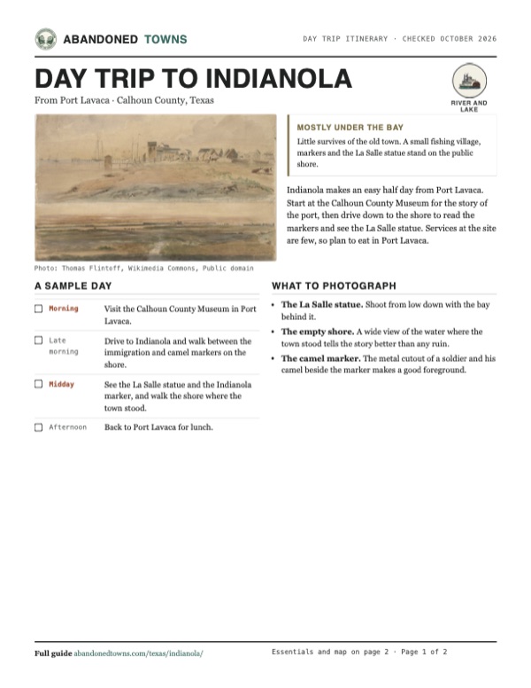
- Two 1852 watercolors of Indianola by Thomas Flintoff: Thomas Flintoff, Wikimedia Commons, Public domain
- The camel experiment marker and cutout, 2023: 2C2K Photography, Wikimedia Commons, CC BY 2.0
- Ocean Drive along Matagorda Bay northwest of the townsite, 2021: BrianGrunberger, Wikimedia Commons, CC BY-SA 4.0
- The 1995 German pioneers stone: WhisperToMe, Wikimedia Commons, CC0
- Area base map, topo and aerial imagery: USGS The National Map (public domain).
- Historic maps: USGS Historical Topographic Map Collection (public domain): Keller Bay 1951, 1:24,000; Beeville 1960, 1:250,000; Port Lavaca 1984, 1:100,000.