 Abandoned

Overview
A cotton town the river wore down

Grafton began in December 1859 as Wheeler, one of the settlements Brigham Young sent south to grow cotton. The Virgin River washed most of it away in January 1862, and the settlers rebuilt a mile upstream under a new name. By 1864 about 28 families farmed about an acre each here. They dug irrigation ditches and planted orchards, some of which still stand.
Farming here was hard. Clogged ditches had to be dredged at least weekly, far more often than in other settlements, and Grafton was the only settlement on the south bank, cut off from its neighbors. In 1866, during the Black Hawk War, the whole town moved to Rockville. People came back, but floods kept driving families across the river. Four families were left by 1890, the church branch closed in 1921, and the last residents left in 1944.
Film crews found it next. Scenes from In Old Arizona (1929) and Butch Cassidy and the Sundance Kid (1969) were shot here. Since June 1997 the Grafton Heritage Partnership, with former residents, the Utah State Historical Society and the BLM, has restored the schoolhouse and several homes. It also bought 150 acres of farmland, kept in pasture to preserve the town's farming look.
Video
Grafton in 30 seconds
A Mormon farming town on the Virgin River: the river in 1929, cabins and fences, the cemetery below the Zion peaks and the restored schoolhouse.
Timeline
Eighty-five years of Grafton

- Settlers from Virgin led by Nathan Tenney start a cotton-growing settlement called Wheeler on the Virgin River, part of Brigham Young's southern Utah cotton project.
- The Great Flood of 1862 largely destroys Wheeler. The settlers rebuild about a mile upriver and name the new town after Grafton, Massachusetts.
- About 28 families live in Grafton, each farming about an acre. They dig irrigation ditches and plant orchards.
- Grafton serves as Kane County seat from January 1866 to January 12, 1867. During the Black Hawk War the whole town moves to Rockville. The heritage partnership counts 13 deaths that year, from diphtheria, scarlet fever, a broken swing and a raid in which Navajo raiders killed three members of the Berry family.
- Families move back to stay. Through the evacuation they had come back daily to work their fields, by Legends of America's account.
- A county boundary change moves Grafton into Washington County.
- Residents build the two-story adobe schoolhouse, also used as church, meeting hall and dance hall. The last classes are held in 1918–19.
- Four families remain. Floods and silted ditches have pushed most people across the river.
- The local branch of the LDS church is discontinued, the date usually given for the town's end.
- The last residents leave.
- Scenes for Butch Cassidy and the Sundance Kid are filmed here.
- The Grafton Heritage Partnership forms to protect and restore the townsite.
What's left
What you'll see

The two-story adobe schoolhouse of 1886 served as school, church and dance hall. Nearby stand the Russell home, an adobe house from about 1888 where Alonzo Russell died in 1910; the 1879 log home he built for his wife Louisa; the Wood home with its log barn, granary and split-rail fence; and the Ballard home and barn from about 1907. Some of the settlers' orchards survive.
Ownership is split. The partnership's fall 2025 newsletter says Washington County owns the schoolhouse, the partnership owns the Russell home and the pastures around town, and the Attiyeh Foundation owns the Louisa Russell home, the Wood home and the Ruby Rose cabin, a log cabin moved here in 1947 for the film Ramrod and rebuilt in 2020.
The cemetery is on the left of the road just before the town. The partnership believes it holds 74 to 84 graves, many now without headstones, of Russell, Wood, Ballard, Berry and York family members and of Southern Paiute people. In the historic maps below, the 1953 sheet names Grafton on the Virgin River west of Rockville, and the 1999 sheet shows its buildings, two lanes and the cemetery ("Cem") south of town. The 1885 and 1891 surveys of the area label Virgin City and Rockville but not Grafton.
- Schoolhouse and meeting hall (1886)
- Russell home (c. 1888)
- Louisa Russell log home (1879)
- Wood home, barn and granary
- Ballard home and barn (c. 1907)
- Ruby Rose cabin (moved 1947, rebuilt 2020)
- Cemetery with the Berry headstone enclosure
- Fields and old orchards


Cemetery
The Grafton cemetery


The partnership manages the cemetery under a cooperative management agreement with the BLM. The agreement lets it replace the fence with like-kind materials, repair the wooden enclosure around the Berry headstone near the center, and add signs on pioneer and Southern Paiute history. Leave the markers as they are.
Historic maps
Grafton on USGS maps, 1953–1999
Crops from the USGS Historical Topographic Map Collection, centered on the townsite. Each sheet shows what surveyors mapped that year; compare them with today's topo and aerial on this page.

Day trip
Plan a day trip to Grafton from Springdale
Take it with you
Day trip itinerary
The essentials, the sample day with boxes to tick, what to photograph and the coordinates, on two printable pages. Handy where there's no signal.
Download the PDF (568 KB)Grafton is about 20 minutes from Springdale, so it fits around a day in Zion. The site is small: a schoolhouse, a handful of homes and a cemetery. There are no services, so bring water and plan restroom stops in Springdale.
A sample day
- Drive from Springdale through Rockville and across the Bridge Road bridge.
- Walk the schoolhouse and the Russell, Wood and Ballard homes.
- Visit the cemetery, then head back to Springdale and Zion.
What to photograph and film
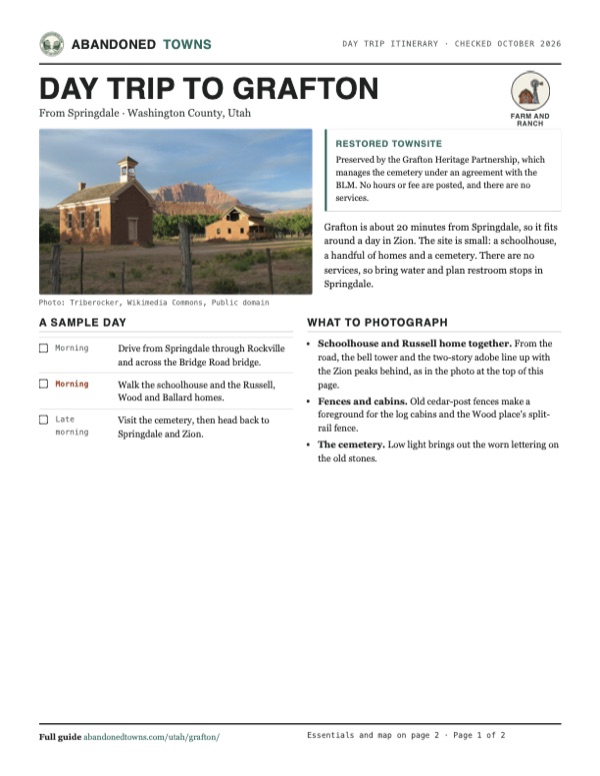
- Schoolhouse and Russell home together. From the road, the bell tower and the two-story adobe line up with the Zion peaks behind, as in the photo at the top of this page.
- Fences and cabins. Old cedar-post fences make a foreground for the log cabins and the Wood place's split-rail fence.
- The cemetery. Low light brings out the worn lettering on the old stones.
Map & directions
Getting there
Springdale, at the Zion entrance, is the nearest town. Drive west on SR 9 through Rockville, turn south on Bridge Road, cross the Virgin River and follow Grafton Road to the townsite. From St. George, take I-15 north and SR 9 east through Hurricane and La Verkin.


Base map: USGS The National Map (public domain). Routes: OSRM on © OpenStreetMap contributors data (ODbL), computed October 2026. Times assume dry roads.
- Head southwest on Zion Park Boulevard, SR 9, into Rockville, where it becomes East Main Street.3.6 mi
- Turn left onto Bridge Road and cross the Virgin River.0.3 mi
- Bear right onto Grafton Road and continue as it becomes 250 South.2.9 mi
- Bear right to the townsite.0.3 mi
- From downtown St. George, take 700 South and River Road to St. George Boulevard and I-15 north.8.6 mi
- Exit onto SR 9 east through Hurricane and La Verkin.28.4 mi
- In Rockville, turn right onto Bridge Road.0.3 mi
- Bear right onto Grafton Road and 250 South to the townsite.3.2 mi
Road and safety notes
- Bridge Road crosses the Virgin River on the one-lane Rockville Bridge, a steel truss bridge opened in 1924. UDOT inspects it every two years; St. George News reported possible minor delays for the March 19, 2026, inspection.
- Past the bridge the route is a dead-end road, and Legends of America says the pavement soon ends. The heritage partnership warns it is impassable in a hard rainstorm.
- There is no water, power or toilet at Grafton. Bring water, especially in summer.
- Fuel and food are in Springdale and Hurricane.
Photos
Grafton in photos
Visitor reports
Been to Grafton?
Been there lately? Tell the next visitor what you found: whether you could get in, the state of the road and what's still standing. Photos are welcome. We read every report before it appears here.
Farm and ranch
More farm and ranch ghost towns
The nearest in Utah.

 Guide
Fruita
38.29, -111.24Wayne County, Utah
A small farming community grew where Sulphur Creek meets the Fremont River. Capitol Reef preserves its orchards, schoolhouse and Gifford farm…
 Guide
Iosepa
40.54, -112.73Tooele County, Utah
Families from Hawaiʻi and other Pacific islands built Iosepa in 1889. Its cemetery remains a place of remembrance for their descendants.
Nearby
Other sites near Grafton
Straight-line distance from the townsite to other mapped sites in our Utah index.
- Adventure0.5 mi SE · Washington
- Duncan's Retreat3.1 mi W · Washington
- Northrop3.7 mi E · Washington
- Silver Reef16.9 mi W · Washington
- Harrisburg17.5 mi W · Washington
- Fort Harmony23.4 mi N · Washington
- Old Irontown36.2 mi NW · Iron
- Hamblin38.9 mi NW · Washington
Sources
Sources and credits
- ghosttowns.com, "Grafton": fact sheet fields (roads, climate, best time).
- Wikipedia, "Grafton, Utah", retrieved October 2026: founding, 1862 flood, families, ditches and isolation, county seat, 1866 evacuation, decline, 1921 and 1944 dates, films, the partnership and its 150 acres of farmland, coordinates.
- Legends of America, "Grafton", updated September 2026: the 1868 return, the 1886 schoolhouse, film use, and the drive in from Rockville, where the pavement ends.
- Grafton Heritage Partnership, historic features, read October 19, 2026: building dates, the Ruby Rose cabin, the 13 deaths of 1866 and their causes, James Jasper York's death, cemetery graves and families, BLM agreement and planned work.
- Grafton Heritage Partnership, "Grafton News Fall 2025", posted November 3, 2025: the open house on the grounds, and who owns the schoolhouse, homes and pastures.
- Grafton Heritage Partnership, directions: route via Bridge Road, rain warning, no services, as of October 19, 2026.
- St. George News, "Traffic delays possible as historic Rockville Bridge undergoes UDOT inspection", March 18, 2026: the one-lane bridge on the way to Grafton, its 1924 opening and its two-year UDOT inspections.
- Coordinates: Wikipedia (from USGS GNIS). Elevation: USGS 3D Elevation Program point query. Routes: OSRM on OpenStreetMap data, October 2026.
Photo and map credits
- The schoolhouse and the Russell home, 2004: Triberocker, Wikimedia Commons, Public domain
- Log cabin and fence, 2009: Jeff Turner from Santa Clarita, CA, United States, Wikimedia Commons, CC BY 2.0
- Pastures on the road in, 2014: Don Graham from Redlands, CA, USA - God bless it!, Wikimedia Commons, CC BY-SA 2.0
- A board swing under a big tree at dusk, 2012: Bureau of Land Management, Wikimedia Commons, Public domain
- James Jasper York's headboard, 2007: mandj98, Wikimedia Commons, CC BY 2.0
- The cemetery below the Zion peaks, 2014: Don Graham from Redlands, CA, USA - God bless it!, Wikimedia Commons, CC BY-SA 2.0
- A two-story adobe house with a porch, below the cliffs, August 2007: inkknife_2000, Wikimedia Commons, CC BY-SA 2.0
- Grafton across the Virgin River, 1929 (NPS): George A. Grant, Wikimedia Commons, Public domain
- Topo map, area base map and aerial imagery: USGS The National Map (public domain).
- Historic maps: USGS Historical Topographic Map Collection (public domain): Cedar City 1953, 1:250,000; Springdale West 1999, 1:24,000.