 Abandoned

Overview
A town in three layers

Kaymoor was a captive mining town. The Low Moor Iron Company of Lowmoor, Virginia, owned the mine, the houses and the store, and it wanted the coal and coke for its own iron furnaces. The company had bought several thousand acres in Virginia and West Virginia in 1873 and opened the mine here at the turn of the century. It was named for its builder and first superintendent, John Kay by the Park Service's account and James Kay by Wikipedia's. The first carload left on August 23, 1900.
The town was built in three layers on the gorge wall. Kaymoor Top on the rim had houses and a store. The bench halfway down held the coal seam and the mine portals. Kaymoor Bottom by the river had more houses, a store, schools, churches, a theater and the plant that sorted coal into railroad cars, by the Park Service's account; Wikipedia says the town had no churches. A 2,200-foot incline, the haulage, carried people and materials between the levels, and there was a staircase for those who would not ride it. Kaymoor had no saloon by company rule and never had a mine explosion, the Park Service says, and more than 800 workers were employed here at the peak.
Low Moor sold out in 1925 to a Berwind-White company, which ran the mine until the seam gave out. With no road to the bottom, families had to leave as the mine wound down in the 1950s, and fire took most of the empty houses. The last coal came out in the 1960s; the Park Service's pages give 1962 and 1965. Berwind gave the core of the site to the Park Service (in 1985 by one Park Service page, 1989 by another), and the park bought the surrounding land in 1989. Some houses of the last group built at Kaymoor Top, called "New Town", are still visible along Gatewood Road.
Timeline
Sixty-odd years of Kaymoor One

- The Low Moor Iron Company of Lowmoor, Virginia, buys several thousand acres in Virginia and West Virginia to fuel its iron furnaces.
- The West Virginia land becomes Kaymoor. Wikipedia and one Park Service page date the mine to 1899; another Park Service page says Low Moor founded Kaymoor in 1900. The first coal ships on August 23, 1900.
- The first 50 company houses go up, all with electricity, and a post office is proposed. More houses follow in 1902, 1905, 1918 and 1923.
- A second mine, Kaymoor Two, opens near present-day Fayetteville. Its store and houses close in 1923 and the mine in 1926.
- The coke ovens grow from 120 to 202 during the First World War, by Wikipedia's count.
- Low Moor sells both Kaymoor mines to the New River and Pocahontas Consolidated Coal Company, a Berwind-White subsidiary. One Park Service page gives the price as $1,001,000; another says it was kept secret.
- The beehive coke ovens shut down as obsolete, and the theater at Kaymoor Bottom closes.
- Wikipedia says Kaymoor Bottom was abandoned by 1952; the Park Service says the company began moving people out in 1955. There was never a road to the bottom, so no one could stay once the mine wound down. Fire destroys most of the remaining houses, in 1958 per the Park Service or 1960 per Wikipedia.
- Kaymoor One ships its last 10,515 tons in 1961 and closes in 1962, by one Park Service page. Another says the company sold the lease in 1963 to the Barbara Gale Coal Company, which closed the mine in 1965.
- Berwind gives the Park Service the core of the mine site (53 acres on December 30, 1985, by one Park Service page; 1989 by another), and the park buys the surrounding 1,375 acres on December 19, 1989.
- Kaymoor is listed on the National Register of Historic Places.
- The tipple is laid on its side at the request of CSX, whose railroad runs below it.
What's left
The bench, the stairs and the bottom


Both trails meet at the bench, where the Park Service's walking tour starts. Its first stops are the stone powder house, the safety board and the metal safety sign over the old haulage path, and the haulage itself. The Park Service says all that is left of the mine is the gated entrance and an old mine car in front of it. From the bench, 821 wooden steps go down to the coal processing plant, the coke ovens and the Kaymoor Bottom townsite near the river. Wikipedia says the site is now heavily overgrown. The Park Service asks visitors not to walk, climb, sit or stand on the structures, and not to dig, use metal detectors or take anything.
The old USGS sheets in the historic maps below show the town arriving. The 1897 sheet has no Kaymoor at all, only Fayetteville, Nuttallburg and their neighbors. By 1908 Kaymoor is marked on the river with the railroad, and the 1928 sheet adds Kaymoor No. 1 up on the plateau, with South Nuttall beside Kaymoor on the south bank, across from Nuttallburg. The 1969 sheet labels the conveyor and Kaymoor No. 1.
- Mine portal and mine car
- Powder house
- Haulage and headhouse
- Safety board and sign
- Conveyor
- Coke ovens
- Coal processing plant ruins
- Kaymoor Bottom townsite
- 821 stairs
- New Town houses along Gatewood Road


Historic maps
Kaymoor on USGS maps, 1897–1969
Crops from the USGS Historical Topographic Map Collection, centered on the townsite. Each sheet shows what surveyors mapped that year; compare them with today's topo and aerial on this page.

Day trip
Plan a day trip to Kaymoor from Fayetteville
Take it with you
Day trip itinerary
The essentials, the sample day with boxes to tick, what to photograph and the coordinates, on two printable pages. Handy where there's no signal.
Download the PDF (674 KB)Kaymoor is a hike, not a drive-up site. From Fayetteville it is 9 minutes to Kaymoor Top, then a steep half mile down to the mine bench, and 821 steps more to the river level if you want the coke ovens and Kaymoor Bottom. Budget a morning and bring water.
A sample day
- Leave Fayetteville; Kaymoor Top is 3.3 miles away, about 9 minutes.
- Start down the Kaymoor Miners Trail (Friday to Sunday through November 19, 2026).
- Reach the bench and follow the walking tour: powder house, safety sign, haulage and headhouse, the gated portal.
- Take the 821 steps down to the processing plant, the coke ovens and Kaymoor Bottom.
- Climb back up the steps and the trail to Kaymoor Top, and drive back to Fayetteville for lunch.
On a Monday to Thursday before November 20, 2026, start instead from the Wolf Creek Trailhead on Fayette Station Road and walk the 2-mile Kaymoor Trail to the bench.
What to photograph and film
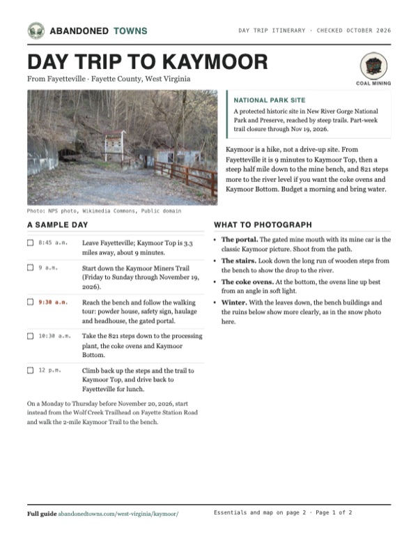
- The portal. The gated mine mouth with its mine car is the classic Kaymoor picture. Shoot from the path.
- The stairs. Look down the long run of wooden steps from the bench to show the drop to the river.
- The coke ovens. At the bottom, the ovens line up best from an angle in soft light.
- Winter. With the leaves down, the bench buildings and the ruins below show more clearly, as in the snow photo here.
Map & directions
Getting there
Fayetteville is next door, about 9 minutes from the Kaymoor Top area. The Charleston route comes down I-64/I-77 and up US 19 into Fayetteville. Both end on Kaymoor Road. For the Kaymoor Top trailhead, the Park Service says to turn left off Gatewood Road at the Kaymoor sign onto Kaymoor No. 1 Road, go about a mile to a T and turn left; the parking is 50 yards on the right. The other way in, the Kaymoor Trail, starts at the Wolf Creek Trailhead on Fayette Station Road.


Base map: USGS The National Map (public domain). Routes: OSRM on © OpenStreetMap contributors data (ODbL), computed October 2026. Times assume dry roads.
- From North Court Street, follow WV 16 south through Fayetteville.0.4 mi
- Turn left on Gatewood Road (CR 9).1.9 mi
- Turn left on Kaymoor Road, signed for Kaymoor, toward the Kaymoor Top trailhead.1.0 mi
- From downtown Charleston, take Lee Street East and Brooks Street (US 60) to the interstate.0.9 mi
- Follow I-64/I-77 south and take the exit for Okey L. Patteson Road.40.3 mi
- Turn left on Okey L. Patteson Road (WV 612) and follow it to its end.8.4 mi
- Turn left onto US 19 north, take the exit ramp and turn right on Lochgelly Road.4.4 mi
- Turn left on Old Fayetteville Road (WV 16) into Fayetteville.3.4 mi
- Turn sharp right on Gatewood Road (CR 9).1.9 mi
- Turn left on Kaymoor Road toward the Kaymoor Top trailhead.1.0 mi
Road and safety notes
- The Kaymoor Top parking lot is small and narrow, and the Park Service says large vehicles, RVs and trailers may not fit.
- Fayette Station Road, the way to the Wolf Creek Trailhead, is narrow and winding with sharp hairpins and a bridge with 12 feet of clearance. Vehicles over 12 feet tall can't use it, and RVs and trailers are not recommended. Obey the no-parking signs at the trailhead.
- The Kaymoor Miners Trail drops steeply about half a mile from the rim, with rocky stairs and switchbacks; the Park Service advises good shoes, plenty of water and possibly hiking poles. The 821 steps to Kaymoor Bottom have to be climbed back up.
- Through November 19, 2026, the upper Kaymoor Miners Trail is closed Monday to Thursday for rehabilitation (NPS, September 24, 2026).
- Camping is prohibited in the Kaymoor historic area, from rim to river (Superintendent's Compendium, July 2026).
- Report vandalism to the park at 304-465-0508.
Photos
Kaymoor in photos
Visitor reports
Been to Kaymoor?
Been there lately? Tell the next visitor what you found: whether you could get in, the state of the road and what's still standing. Photos are welcome. We read every report before it appears here.
Coal mining
More coal mining ghost towns
The nearest in West Virginia.

 Guide
Nuttallburg
38.05, -81.04Fayette County, West Virginia
John Nuttall's coal town at the mouth of Short Creek, leased by Henry Ford in the 1920s, mined out in 1958 and a ghost town by the early 1960s. The…
 Guide
Sewell
38.00, -81.02Fayette County, West Virginia
A coal and coke town on the New River, where nearly 200 beehive ovens burned until 1956 and the last resident left in 1973. The ovens, an office…
Nearby
Other sites near Kaymoor
Straight-line distance from the townsite to other mapped sites in our West Virginia index.
- Fayette1.2 mi NW · Fayette
- Nuttallburg1.3 mi E · Fayette
- Nuttallburg Coal Mining Complex and Town Historic District1.3 mi E · Fayette
- South Nuttall1.5 mi E · Fayette
- South Fayette1.5 mi NW · Fayette
- Newlyn2.0 mi NW · Fayette
- Keeneys Creek2.1 mi E · Fayette
- Carver2.2 mi NW · Fayette
Sources
Sources and credits
- ghosttowns.com, "Kaymoor": fact sheet fields (county, climate, best time).
- Wikipedia, "Kay Moor, West Virginia", retrieved October 2026: the 1873 purchase, the 1899 opening, James Kay, 50 houses in 1901, the 1925 sale, coke oven counts, Kaymoor Bottom abandoned by 1952, the fire, the 1962 end of the inclines, the National Register listing, the bench's height, overgrowth, coordinates.
- National Park Service, "Visiting Kaymoor", updated September 12, 2025: the 1900 founding, John Kay, the first shipment, total production, the $1,001,000 sale, wages, no explosions, 800 workers, the 1961 and 1962 dates, the 1985 and 1989 land transfers, the trails, 821 steps, directions and driving advisories.
- National Park Service, "Kaymoor", updated September 12, 2025; "Living in Kaymoor" and "After the Coal Town", updated September 14, 2025: the 1901 post office proposal, Kaymoor Two, the secret sale price, the three levels, the 2,200-foot haulage, housing, the theater, the 1955 move-out, the 1958 fire, the 1963 and 1965 dates, the 1989 gift, the 1999 tipple.
- National Park Service, "Kaymoor Mine Walking Tour", updated September 12, 2025: the bench stops, the New Town houses along Gatewood Road, the 500-foot descent, preservation rules.
- National Park Service, "Road and Trail Closures", updated September 24, 2026: the Kaymoor Miners Trail closure. "Fees & Passes", read October 20, 2026: no entrance fee. "Operating Hours & Seasons", updated October 1, 2024: the park is open year-round. "Superintendent's Compendium", updated July 6, 2026: drones prohibited without written approval; no camping in the Kaymoor historic area.
- Photos: Wikimedia Commons, credited below each one. Elevation: USGS 3D Elevation Program point query. Routes: OSRM on OpenStreetMap data, October 2026. Not field-checked.
Photo and map credits
- The mine bench, with a gated portal at left and mine buildings at right: NPS photo, Wikimedia Commons, Public domain
- The conveyor at the screening house, December 1986: Jet Lowe, Wikimedia Commons, Public domain
- The bench under snow, with fences, stairs and a mine building: NPS photo/Dave Bieri, Wikimedia Commons, Public domain
- Wooden stairs on the way down to Kaymoor Bottom: NPS photo/Dave Bieri, Wikimedia Commons, Public domain
- A mine car in front of the gated portal: NPS photo/Dave Bieri, Wikimedia Commons, Public domain
- Miners on an electric locomotive at a drift mouth, 1914: NPS photo, Wikimedia Commons, Public domain
- Historic American Engineering Record section of the headhouse, 1986: mine cars tipped coal into a storage bin that fed cars down the incline: Michael P. O'Boyle, HAER investigator, Wikimedia Commons, Public domain
- Area base map, topo and aerial imagery: USGS The National Map (public domain).
- Historic maps: USGS Historical Topographic Map Collection (public domain): Kanawha Falls 1897, 1:125,000; Fayetteville 1908, 1:48,000; Fayetteville 1910, 1:62,500; Fayetteville 1928, 1:62,500; Fayetteville 1969, 1:24,000.