 Abandoned
Overview
Capital for 46 days

The Wisconsin Territory was created in 1836 from part of the Michigan Territory. John Atchison, a Galena merchant who had laid out a town called Belmont the year before, put up buildings to tempt the lawmakers. Governor Henry Dodge chose Belmont on September 9, 1836. Wikipedia says the lead-mining country around it was a likely reason, though some suspected Dodge's ties to Atchison.
The first legislature met in Atchison's Council House from October 25 to December 9, 1836. The Historical Society pictures them huddled in the cold, and before going home they named Madison the permanent capital. That decision ended Belmont's prospects. People and businesses drifted away, though the town kept a post office and a few businesses for another three decades.
In 1867 the railroad came through about three miles to the southeast. Most residents moved to the tracks and took the name Belmont with them; today's village of Belmont had 989 people in 2020. The old town became Grandview, and a later station just north of it was named Leslie. The Council House and the lodging house survived as homes and then barns until women's clubs saved them in the 20th century. Both now stand on the First Capitol Historic Site, a museum run by the Wisconsin Historical Society.
Timeline
Rise and removal
- John Atchison, a merchant from Galena, Illinois, lays out Belmont in the lead-mining country of southwestern Wisconsin. The name is French for beautiful hill.
- Atchison starts four public buildings to win the capital. On September 9, 1836, Governor Henry Dodge names Belmont the seat of the new Wisconsin Territory, at least for the first session.
- The first territorial legislature meets in Atchison's Council House. In 46 days it passes 42 laws, sets up the courts, calls for roads and railroads, and picks Madison as the permanent capital.
- The legislature meets next at Burlington, now in Iowa, while Madison's capitol is built. People and businesses leave Belmont.
- The Mineral Point Railroad passes about three miles to the southeast. Most residents move there and take the name Belmont with them; the old town becomes known as Grandview.
- The Chicago and North Western sets a station just north of Grandview, named Leslie.
- The Wisconsin Federation of Women's Clubs raises money to save the two surviving buildings, by then used as barns. The Council House is moved to its present site and restored in 1924.
- The lodging house, once the home of territorial Chief Justice Charles Dunn, is moved to the site and restored.
- The site is listed on the National Register of Historic Places on April 28, 1970.
- The Wisconsin Historical Society takes the site over from the Department of Natural Resources.
- The legislature returns to Belmont for a session marking Wisconsin's 150 years of statehood.
What's left
What you'll see

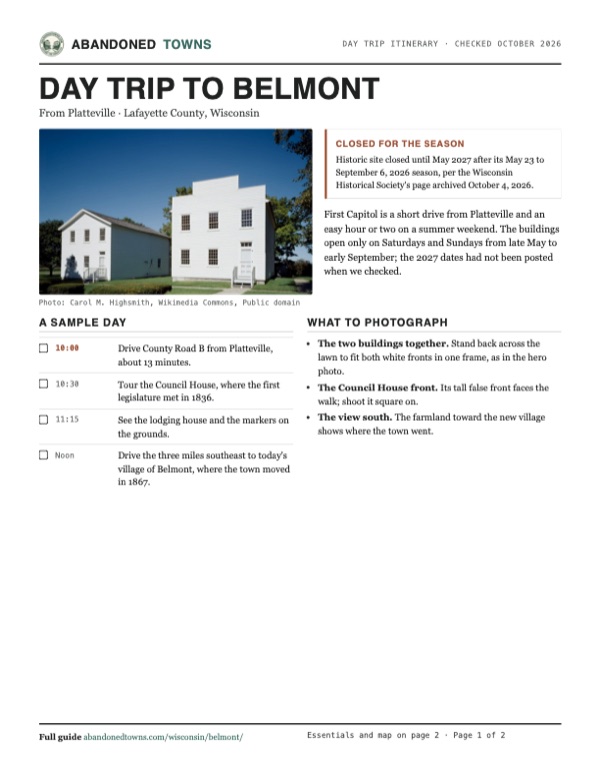
Two buildings are all that is left of the territorial town, and both have moved at least once. The Council House, where the legislature met, was moved to its current site and restored in 1924. The lodging house, where members boarded and Chief Justice Charles Dunn later lived, followed in 1956. Inside, the Society shows the rooms where the first laws were made. Both have wheelchair ramps, though the Society says access inside is limited by the old proportions. Parking is free on site. Pets are not allowed on the grounds; service animals are.
Nothing else of the 1836 town stands. On the 1902 USGS sheet below, Leslie sits on the Galena line below the Platte Mounds, with the new village of Belmont on the Chicago and Milwaukee line to the southeast. The 1952 sheet marks First Capitol State Park at the junction of highways G and B, beside the cluster of houses at Leslie, with Belmont Mound and its quarry to the east.
- The Council House (1836), restored 1924
- The lodging house (1836), restored 1956
- Historical markers on the grounds


Historic maps
Belmont on USGS maps, 1902–1952
Crops from the USGS Historical Topographic Map Collection, centered on the townsite. Each sheet shows what surveyors mapped that year; compare them with today's topo and aerial on this page.

Day trip
Plan a day trip to Belmont from Platteville
Take it with you
Day trip itinerary
The essentials, the sample day with boxes to tick, what to photograph and the coordinates, on two printable pages. Handy where there's no signal.
Download the PDF (549 KB)First Capitol is a short drive from Platteville and an easy hour or two on a summer weekend. The buildings open only on Saturdays and Sundays from late May to early September; the 2027 dates had not been posted when we checked.
A sample day
- Drive County Road B from Platteville, about 13 minutes.
- Tour the Council House, where the first legislature met in 1836.
- See the lodging house and the markers on the grounds.
- Drive the three miles southeast to today's village of Belmont, where the town moved in 1867.
What to photograph and film
- The two buildings together. Stand back across the lawn to fit both white fronts in one frame, as in the hero photo.
- The Council House front. Its tall false front faces the walk; shoot it square on.
- The view south. The farmland toward the new village shows where the town went.
Map & directions
Getting there
Platteville is the closest city, about 13 minutes away on County Road B. From Madison the drive follows the Beltline and US 18/151 southwest, about an hour and a half.


Base map: USGS The National Map (public domain). Routes: OSRM on © OpenStreetMap contributors data (ODbL), computed October 2026. Times assume dry roads.
- From downtown Platteville, turn left on West Main Street, then left on County Road B.0.4 mi
- Follow County Road B (Broadway Street, then County Road B) east.3.7 mi
- At the end of the road, turn left on West Mound Road (still County Road B).0.2 mi
- Continue on County Road B to County Road G and the site.2.5 mi
- From East Mifflin Street, turn left on North Carroll Street and right on West Washington Avenue.1.3 mi
- Turn left on South Park Street (US 151), which becomes Fish Hatchery Road.1.9 mi
- Take the ramp onto the West Beltline Highway.2.1 mi
- Take exit 258 onto US 18/151 southwest.58.9 mi
- Take the exit and turn right on County Highway G.0.8 mi
- Continue on County Road G to the site.2.0 mi
Road and safety notes
- The site is on County Road G at County Road B, north of the village of Belmont and US 151.
- Free parking on site, per the Wisconsin Historical Society.
Photos
Belmont in photos
Visitor reports
Been to Belmont?
Been there lately? Tell the next visitor what you found: whether you could get in, the state of the road and what's still standing. Photos are welcome. We read every report before it appears here.
Nearby
Other sites near Belmont
Straight-line distance from the townsite to other mapped sites in our Wisconsin index.
- Pendarvis (Mineral Point11.7 mi NE · Iowa
- Potosi18.6 mi W · Grant
- Sinnipee20.1 mi SW · Grant
- Pleasant Ridge23.3 mi W · Grant
- Adamsville24.7 mi NE · Iowa
- Farmers Grove32.4 mi E · Green
- Corwin50.9 mi N · Richland
- Cooksville57.1 mi E · Rock
Sources
Sources and credits
- ghosttowns.com, "Belmont": fact sheet fields (county, road, climate, best time, remains), the 46 days, the move of the town and railroad about three miles away, the restored buildings.
- Wikipedia, "First Capitol Historic Site", retrieved October 2026: coordinates, Atchison and the four buildings, Dodge's choice of September 9, 1836, the suspected ties, the session dates and 42 acts, Burlington, Charles Dunn, the 1910, 1924 and 1956 restorations, the National Register listing of April 28, 1970, the 1994 transfer, the 1867 move after the railroad bypassed the town.
- Wikipedia, "Belmont, Wisconsin", retrieved October 2026: the village's founding in 1835 and its 2020 population of 989.
- Wisconsin Historical Society, First Capitol: "Plan Your Visit", archived copy of October 4, 2026 (the live site is behind a bot wall): closed for the season until May 2027, the 2026 season and hours, free entry and the $2 donation, free parking, ramps, pets and weapons rules, the phone; and "History of First Capitol", archived copy of January 12, 2025: the session dates and 42 laws, Madison chosen, the post office until 1867, Grandview, Leslie in 1884, the barns, the 1924 and 1956 moves.
- Travel with a Wiseguy, "Belmont, Wisconsin ||| First Capital of the Wisconsin Territory 1836", YouTube, posted October 10, 2024: the 1998 legislative session at the site and the buildings standing on the grounds.
- Elevation: USGS 3D Elevation Program point query. Routes: OSRM on OpenStreetMap data, October 2026.
Photo and map credits
- The Council House and lodging house, between 1980 and 2006: Carol M. Highsmith, Wikimedia Commons, Public domain
- The capitol at Belmont as drawn in 1903: Benjamin F. Gue, History of Iowa (1903), Wikimedia Commons, Public domain
- Leslie and the Platte Mounds on the 1902 USGS Mineral Point sheet, with the new Belmont to the southeast: U.S. Geological Survey, USGS catalog, Public domain
- First Capitol State Park and Leslie on the 1952 USGS Mifflin sheet: U.S. Geological Survey, USGS catalog, Public domain
- Area base map, topo and aerial imagery: USGS The National Map (public domain).
- Historic maps: USGS Historical Topographic Map Collection (public domain): Mineral Point 1902, 1:125,000; Mifflin 1952, 1:24,000.