 Abandoned

Overview
A railroad town the tracks left behind

Piedmont began around 1867 as a camp cutting ties for the Union Pacific, which was building west across southern Wyoming. It was first called Byrne, after the family that ran it, and renamed when the name kept being confused with Bryan Station. When the tracks arrived in 1868, trains needed helper engines on the eight-mile grade beyond town, and Piedmont became a wood and water stop with sidings, an engine house, a water tank and a telegraph office. The Guild family ran a store, and Wikipedia counts four saloons. In May 1869, by the Wyoming Livestock Roundup's account, railroad workers held Union Pacific vice president Thomas Durant here until they were paid, delaying the Golden Spike ceremony in Utah.
Moses Byrne, a Mormon pioneer who ran the station, built the beehive-shaped limestone kilns beside it to burn timber from the Uinta Mountains into charcoal for Utah's iron smelters. The state dates them to 1869; Wikipedia says 1877. The SHPO listing says more than forty kilns worked in the area at one time, and that the price of charcoal fell from 27 cents a bushel to 7 cents in the lean years.
The end came when the Union Pacific bored the Aspen Tunnel, about a mile and a half long, and moved the line off the old grade. Piedmont was left several miles from the tracks. The Guild store closed in 1940 and most of the buildings were hauled away. The old grade is now the county road. The state's page repeats the story that Butch Cassidy and Calamity Jane spent time here; we found nothing to confirm it, so treat it as legend.
Timeline
Ties, charcoal and a tunnel

- The Guild family joins the Byrne family at Muddy River Station, having come from Salt Lake City.
- A camp grows up to cut ties for the Union Pacific. It is first called Byrne, then renamed Piedmont because the name was being confused with Bryan Station.
- The railroad arrives. Helper engines are needed on the eight-mile grade, so Piedmont becomes a wood and water stop with sidings, an engine house and a water tank.
- On the way to the Golden Spike ceremony at Promontory, Union Pacific vice president Thomas Durant is held at Piedmont by workers demanding their pay. A 2009 Wyoming Livestock Roundup article says the ceremony went ahead two days late; the state's page says three.
- Moses Byrne builds charcoal kilns beside the station to supply Utah's smelters. The state's page says four were built; the SHPO listing says five. Wikipedia instead dates the kilns to 1877, at a cost of $1,500.
- An estimated 100,000 bushels of charcoal: the state gives it as that year's output, the SHPO listing as a month's.
- The Aspen Tunnel takes the main line around the old grade, and Piedmont is stranded. Sources disagree on the date: the Wyoming Livestock Roundup gives October 2, 1902, Wikipedia about 1910 and an undated listing 1901.
- The Guild Mercantile closes for lack of business. Most of the buildings are hauled away afterward.
- The surviving kilns are listed on the National Register of Historic Places.
- Cowboy State Daily describes the kilns beside a graded dirt road on County Road 173.
What's left
Three kilns and a row of empty houses


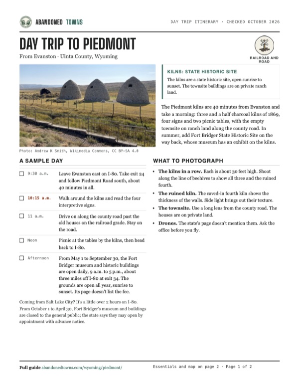
The kilns are the public part of Piedmont. Each is about 30 feet across and 30 feet high, and three are whole; the fourth has caved in, which is why the state counts three and a half. The site has four interpretive signs and two picnic tables, and the Fort Bridger State Historic Site museum has an exhibit about them.
West of the kilns, along the county road on the old railroad grade, a few abandoned frame buildings still stand. Wikipedia lists three or four tumbledown houses, foundations, the coal dump where the engine house stood, and cemeteries; an undated listing counts about a dozen mostly intact wood buildings and a family cemetery uphill from the kilns, and the state's page mentions the Byrne family cemetery nearby. These are on private ranch land: look from the road.
The 1954 USGS sheet in the historic maps below labels the site "Piedmont (abandoned)" beside Big Muddy Creek, with the Piedmont and Guild reservoirs to the southwest and south. The main line runs well to the northwest, past Aspen Station and Altamont and through the railroad tunnels. The 1980 sheet shows the road on the old grade crossing Muddy Creek at Piedmont, with a reservoir on Piedmont Creek just west of the townsite.
- Three charcoal kilns (1869)
- Ruined fourth kiln
- Interpretive signs and picnic tables
- Abandoned houses (private)
- Foundations and coal dump
- Byrne family cemetery (private)
- Old Union Pacific grade, now the county road


Historic maps
Piedmont on USGS maps, 1954–1980
Crops from the USGS Historical Topographic Map Collection, centered on the townsite. Each sheet shows what surveyors mapped that year; compare them with today's topo and aerial on this page.

Day trip
Plan a day trip to Piedmont from Evanston
Take it with you
Day trip itinerary
The essentials, the sample day with boxes to tick, what to photograph and the coordinates, on two printable pages. Handy where there's no signal.
Download the PDF (598 KB)The Piedmont kilns are 40 minutes from Evanston and take a morning: three and a half charcoal kilns of 1869, four signs and two picnic tables, with the empty townsite on ranch land along the county road. In summer, add Fort Bridger State Historic Site on the way back, whose museum has an exhibit on the kilns.
A sample day
- Leave Evanston east on I-80. Take exit 24 and follow Piedmont Road south, about 40 minutes in all.
- Walk around the kilns and read the four interpretive signs.
- Drive on along the county road past the old houses on the railroad grade. Stay on the road.
- Picnic at the tables by the kilns, then head back to I-80.
- From May 1 to September 30, the Fort Bridger museum and historic buildings are open daily, 9 a.m. to 5 p.m., about three miles off I-80 at exit 34. The grounds are open all year, sunrise to sunset. Its page doesn't list the fee.
Coming from Salt Lake City? It's a little over 2 hours on I-80. From October 1 to April 30, Fort Bridger's museum and buildings are closed to the general public; the state says they may open by appointment with advance notice.
What to photograph and film
- The kilns in a row. Each is about 30 feet high. Shoot along the line of beehives to show all three and the ruined fourth.
- The ruined kiln. The caved-in fourth kiln shows the thickness of the walls. Side light brings out their texture.
- The townsite. Use a long lens from the county road. The houses are on private land.
- Drones. The state's page doesn't mention them. Ask the office before you fly.
Map & directions
Getting there
Evanston is the closest city, 26.8 miles and about 39 minutes away: I-80 east, then 7.5 miles south on Piedmont Road (County Road 173). The state's page names the I-80 exit as exit 24, Leroy Road. From Salt Lake City the route joins I-80 and takes the same exit. Both routes pass the kilns and end on Piedmont Road about half a mile farther on, 220 meters from the mapped town point. They are computed from OpenStreetMap and haven't been driven by us.


Base map: USGS The National Map (public domain). Routes: OSRM on © OpenStreetMap contributors data (ODbL), computed October 2026. Times assume dry roads.
- From Bear River Drive, turn left on Front Street (I-80 Business) and take the ramp to the interstate.1.0 mi
- Merge onto I-80 east (Dwight D. Eisenhower Highway, with US 189).18.2 mi
- Take the exit and turn right on Piedmont Road (County Road 173) to Piedmont.7.7 mi
- From Main Street, turn right on 300 South and right on State Street (SR 186), then left to the interstate.3.6 mi
- Merge onto I-80 east and follow it into Wyoming.97.0 mi
- Take the exit and turn right on Piedmont Road (County Road 173) to Piedmont.7.7 mi
Road and safety notes
- Cowboy State Daily (May 2025) describes the kilns beside a graded dirt road on a seldom-traveled stretch of County Road 173.
- A visitor's report from 1999 called the I-80 route fine for 2WD, and found the longer approach from WY 150 on County Road 173 muddy and rutted after rain. That report is old; ask Fort Bridger State Historic Site about current conditions.
- The townsite buildings are on private ranch land. Stay on the road and leave gates as you find them.
Photos
Piedmont in photos
Visitor reports
Been to Piedmont?
Been there lately? Tell the next visitor what you found: whether you could get in, the state of the road and what's still standing. Photos are welcome. We read every report before it appears here.
Railroad and road
More railroad, road and fort ghost towns
The nearest in Wyoming.

 Guide
Point of Rocks
41.68, -108.79Sweetwater County, Wyoming
A stage stop of 1862 on the Overland Trail where the Union Pacific arrived in 1868, and a starting point for the road to the South Pass gold camps.…
 Guide
Fort Fred Steele
41.78, -106.95Carbon County, Wyoming
An Army post built in 1868 to guard the Union Pacific bridge over the North Platte. After the soldiers left in 1886 it lived on as a tie, sheep and…
Nearby
Other sites near Piedmont
Straight-line distance from the townsite to other mapped sites in our Wyoming index.
- Fort Supply10.5 mi E · Uinta
- Bear River City13.0 mi W · Uinta
- Fort Bridger14.3 mi NE · Uinta
- Almy21.1 mi W · Uinta
- Bear River23.7 mi NW · Uinta
- Lonetree27.3 mi SE · Uinta
- Opal41.3 mi N · Lincoln
- Sage44.6 mi N · Lincoln
Sources
Sources and credits
- ghosttowns.com, "Piedmont": fact-sheet fields (roads, climate, best time, remains, the 1901 tunnel date, private ranch).
- Wikipedia, "Piedmont, Wyoming", retrieved October 2026: coordinates, the Guild and Byrne families, the Byrne name and Bryan Station, the 1868 wood and water stop, the saloons, the 1877 kiln date and cost, the Aspen Tunnel about 1910, the 1940 store closing, the remains and the 1971 listing.
- Wyoming State Parks, "Piedmont Charcoal Kilns State Historic Site", read October 20, 2026: open daily sunrise to sunset, I-80 exit 24, County Road 173, phone, three and a half kilns, signs and picnic tables, 1869, four kilns, size, the 1873 estimate, the Golden Spike delay, Butch Cassidy and Calamity Jane. Historical features: the Byrne family cemetery nearby.
- Wyoming SHPO, "Piedmont Charcoal Kilns", read October 2026: five kilns about 1869, the station's roundhouse, water tank and telegraph office, more than forty kilns in the area, prices, the June 3, 1971 listing, the old grade as a county road.
- Wyoming State Parks, "Fort Bridger State Historic Site", read October 21, 2026: grounds, museum and building hours by season, appointments in winter, exit 34, phone, restrooms. The kilns page was read again the same day for the day trip.
- Wyoming Livestock Roundup, "Piedmont central to Uinta County's history", October 16, 2009: Durant and the Golden Spike, the Aspen Tunnel on October 2, 1902, the kilns, and the town's remains on the Guild family ranch.
- Zakary Sonntag, Cowboy State Daily, May 25, 2025: the kilns beside a graded dirt road on County Road 173, built in 1869.
- Photos: Wikimedia Commons, credited below each one. Elevation: USGS 3D Elevation Program point query. Routes: OSRM on OpenStreetMap data, October 2026. Not field-checked.
Photo and map credits
- The three kilns and the ruined fourth from the viewing walk, September 2020: Andrew K Smith, Wikimedia Commons, CC BY-SA 4.0
- Abandoned houses along the county road, May 2021: Beneathtimp, Wikimedia Commons, CC0
- The kilns under repair, with scaffolding, beside the gravel road, October 2010: Tricia Simpson, Wikimedia Commons, CC BY-SA 3.0
- The broken fourth kiln, September 2020: Andrew K Smith, Wikimedia Commons, CC BY-SA 4.0
- The kilns in snow, April 2023: TexasSpyder, Wikimedia Commons, CC BY-SA 4.0
- The kilns and a footbridge over the ditch, 1974, for the Historic American Buildings Survey: Boucher, Jack E., Wikimedia Commons, Public domain
- The log truss footbridge over the stream beside the kilns, 1974: Jack Boucher, Wikimedia Commons, Public domain
- Inside a kiln: smoke-blackened stone above the lighter base, September 2020: Andrew K Smith, Wikimedia Commons, CC BY-SA 4.0
- Area base map, topo and aerial imagery: USGS The National Map (public domain).
- Historic maps: USGS Historical Topographic Map Collection (public domain): Ogden 1954, 1:250,000; Evanston 1980, 1:100,000.