 Abandoned

Overview
The gold camp where women first held office

South Pass City sits on Willow Creek at about 7,800 feet, at the southern tip of the Wind River Range. It is named for nearby South Pass, on the emigrant route that, by WyoHistory's account, hundreds of thousands of people traveled in the 20 years before the town was founded. Gold was found nearby in 1867, the town was laid out that year, and work began on the Carissa lode in 1868. Within a year about 2,000 people had arrived; an undated listing says the town reached about 4,000 in 1870.
The camp's lasting fame is political. William H. Bright, a South Pass City saloon keeper who was president of the territorial council, introduced the bill that gave Wyoming women the vote, and the governor signed it on December 10, 1869. Two months later Esther Hobart Morris became the town's justice of the peace, the first woman in the country to hold that office. Wikipedia says she was appointed after the sitting justice, R. S. Barr, resigned in protest at the suffrage law; WyoHistory names her predecessor as James Stillman.
The gold didn't last. The district produced about $7 million in all, by WyoHistory's figure, but the big deposits people expected never turned up and the population fell to about 100 by the mid-1870s. A few businesses held on, and the last pioneer families left in 1949. The town was given to the state about a century after its founding, and in 2003 the legislature bought the Carissa Mine as well. Today Wyoming State Parks keeps more than 30 historic structures, restores them with the Friends of South Pass City, and opens them to visitors each summer.
Timeline
From gold strike to state historic site

- Samuel Clemens rides through by stagecoach. In Roughing It (1872) he describes South Pass City as four log cabins and about ten citizens, one of whom held most of the local offices.
- Gold is found nearby and the town is laid out. Wikipedia says about 2,000 people arrive within a year; an undated listing puts the 1870 peak at about 4,000.
- Prospecting starts on what becomes the Carissa Mine. WyoHistory says it had produced more than $15,000 in gold by 1868, when ore could only be worked by hand.
- Governor John Allen Campbell signs the women's suffrage bill introduced by William H. Bright, a South Pass City saloon keeper and president of the territorial council. Wyoming women can vote and hold office.
- Esther Hobart Morris takes office as justice of the peace, the first woman to hold the post in the United States. WyoHistory says she heard 34 cases before her term ended on November 14, 1870.
- The hoped-for big deposits don't appear. Wikipedia puts the population at about 100.
- About 180 people live in town.
- The last pioneer families leave.
- The town is given to the State of Wyoming, about a century after it was founded. WyoHistory gives no exact year.
- South Pass City is listed on the National Register of Historic Places.
- The Wyoming Legislature buys the Carissa Mine and adds it to the historic site.
- The buildings open daily from Memorial Day to mid-October. Gold Rush Days is held on July 11 and 12, and the Friends take reservations for Carissa mill and English Tunnel tours.
What's left
Main street, cabins and the Carissa


The restored town lines one main street along Willow Creek: log cabins, false-front stores, a hotel and restaurant, a jail and a dance hall that serves as the gift shop. WyoHistory names the E. A. Slack cabin, the Carissa Saloon, the Exchange Bank and the South Pass Hotel among the restored buildings. The state's page adds an 1860s billiard table and a 1900s-style general store, open when volunteers are on hand, and gold panning in Willow Creek every day, with vials sold in the Dance Hall Gift Shop. Three hiking trails with interpretive signs leave from town, and the Continental Divide National Scenic Trail passes through.
Up the hill to the northeast stand the buildings of the Carissa Mine, which the state bought in 2003 and made safe with the Abandoned Mine Lands program. The Friends of South Pass City run tours of the Carissa mill and the English Tunnel by reservation through their tours page; the "fully booked for 2026" note on that page belongs to its school tours.
The 1953 USGS sheet in the historic maps below shows the town's buildings strung along the creek, the Carissa Mine to the northeast, the Franklin Mine to the west, the Shields Mine to the east, and a cemetery and landing strips on the flat to the south. The 1984 sheet adds the B & H Mine to the east and the Duncan and Tabor Grande mines to the northeast.
- More than 30 historic structures
- Main street of log and false-front buildings
- South Pass Hotel and restaurant
- Jail
- Exchange Bank and Carissa Saloon
- Dance hall (gift shop)
- Carissa Mine buildings
- Cemetery
- Three interpretive trails


Historic maps
South Pass City on USGS maps, 1953–1991
Crops from the USGS Historical Topographic Map Collection, centered on the townsite. Each sheet shows what surveyors mapped that year; compare them with today's topo and aerial on this page.

Day trip
Plan a day trip to South Pass City from Lander
Take it with you
Day trip itinerary
The essentials, the sample day with boxes to tick, what to photograph and the coordinates, on two printable pages. Handy where there's no signal.
Download the PDF (484 KB)From Lander, South Pass City is a 46-minute drive and an easy day in summer. Walk the main street and the cabins in the morning, pan for gold in Willow Creek, and in the afternoon look at Miner's Delight, a ghost town the Bureau of Land Management manages near Atlantic City. Outside the building season you can still walk the grounds and trails.
A sample day
- Leave Lander on US 287 and WY 28. The drive is 34.1 miles, about 46 minutes.
- The buildings open. Start at the Dance Hall Gift Shop, then walk the main street: the hotel, the jail, the Exchange Bank and the cabins.
- Pan for gold in Willow Creek. The gift shop sells vials for what you find.
- Picnic lunch, then walk one of the three signed trails or look up at the Carissa Mine buildings on the hill.
- Drive to Atlantic City and on to Miner's Delight. The BLM's directions: north on County Road 237 from Atlantic City, east about 2 miles on BLM Road 2324, then follow the signs. No fee; the path through the site is rugged.
- Head back to Lander.
This plan works from Memorial Day to mid-October. The rest of the year the buildings are closed, but the grounds and trails stay open when weather allows. Coming from Casper? It's a 182-mile drive of about 3 h 39 min each way.
What to photograph and film
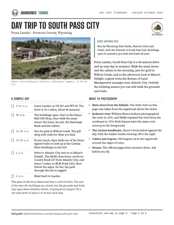
- Main street from the hillside. The wide view on this page was taken from the sagebrush above the street.
- Jackson's view. William Henry Jackson photographed the town in 1870, and HABS repeated his view from the southeast in 1974. Both frames have the same rock outcrop in the foreground.
- The Carissa headframe. Shoot it from below against the sky, with the timber trestle running off to the right.
- Cabins and wagons. Old wagons sit in the sagebrush around the edges of town.
- Drones. The official pages don't mention them. Ask before you fly.
Map & directions
Getting there
Lander is the closest city, 34 miles and about 46 minutes away by US 287 and WY 28. From Casper the drive runs west on US 20/26 and US 26/WY 789, then joins the same road over WY 28. Both routes end on South Pass City Road and South Pass Main Street. They are computed from OpenStreetMap and haven't been driven by us.


Base map: USGS The National Map (public domain). Routes: OSRM on © OpenStreetMap contributors data (ODbL), computed October 2026. Times assume dry roads.
- Head out of Lander on Main Street (US 287).8.8 mi
- Continue straight on Highway 28 (WY 28).22.9 mi
- Turn left on South Pass City Road.2.2 mi
- Turn left on South Pass Main Street into town.0.2 mi
- From North Sunlight Drive, follow East Sunlight Drive and the Bryan Stock Trail, then turn right on East F Street and take the US 20/26 highway west.4.3 mi
- Exit, turn left on Events Drive and continue on the US Highway 20-26 Bypass.3.4 mi
- Turn right on West Yellowstone Highway and follow US 20/26 west.94.3 mi
- Continue on US 26/WY 789 and South Main Street (WY 789), then turn left on East Main Street (US 287/WY 789).54.7 mi
- Continue straight on Highway 28 (WY 28).22.9 mi
- Turn left on South Pass City Road, then left on South Pass Main Street.2.4 mi
Road and safety notes
- The routes are computed from OpenStreetMap and haven't been driven by us. We found no dated source on the road surface into town.
- At about 7,800 feet, snow can come early and late. The state says the site and trails are open year-round only when the weather permits.
- Stay out of mine openings. Tour the Carissa only with the Friends' guides.
Photos
South Pass City in photos
Visitor reports
Been to South Pass City?
Been there lately? Tell the next visitor what you found: whether you could get in, the state of the road and what's still standing. Photos are welcome. We read every report before it appears here.
Gold mining
More gold mining ghost towns
The nearest in Wyoming.

 Guide
Atlantic City
42.50, -108.73Fremont County, Wyoming
Gold on Rock Creek drew some 2,000 people to Atlantic City in its first boom, from 1868. The boom lasted barely five years; dredges and an iron mine…
 Guide
Kirwin
43.88, -109.30Park County, Wyoming
A gold and silver camp at the head of the Wood River, ringed by peaks near 12,000 feet. About 200 people lived here around 1905; an avalanche in 1907…
Nearby
Other sites near South Pass City
Straight-line distance from the townsite to other mapped sites in our Wyoming index.
- Atlantic City4.0 mi NE · Fremont
- Hamilton7.6 mi NE · Fremont
- New Fork49.3 mi W · Sublette
- Superior49.5 mi S · Sweetwater
- Jeffrey City49.5 mi E · Fremont
- Winton53.3 mi S · Sweetwater
- Point of Rocks54.6 mi S · Sweetwater
- Dines54.7 mi S · Sweetwater
Sources
Sources and credits
- ghosttowns.com, "South Pass City": fact-sheet fields (roads, climate, best time, remains, an 1870 peak of about 4,000).
- Wikipedia, "South Pass City, Wyoming", retrieved October 2026: coordinates and elevation, Mark Twain's 1861 visit, the 1867 discovery and the Carissa from 1868, about 2,000 people within a year, Bright and the suffrage bill, Esther Morris and R. S. Barr, population in the 1870s and 1901, the last families in 1949, more than 30 structures, the 2003 Carissa purchase, the National Register listing, and climate normals.
- WyoHistory.org and the Wyoming SHPO, "South Pass City", November 8, 2014: the 1867 layout, the Carissa's $15,000 by 1868, about $7 million from the district, Bright, Morris's term and 34 cases, James Stillman, the gift to the state, restored buildings. Its visiting season is out of date and not used.
- Wyoming State Parks, Historic Sites and Trails, "South Pass City State Historic Site", read October 20, 2026: building and gift shop hours, year-round grounds and trails, address, phone, gold panning, billiards, the general store, trails and the Continental Divide Trail.
- Wyoming State Parks, "Permits & Fees" (2026 fee schedule), read October 20, 2026: historic sites $4 a day per adult for residents, $8 for nonresidents, children free.
- Friends of South Pass City, read October 20, 2026: hours, admission ($8, $4 Wyoming residents, 17 and under free), address and phone; events (Gold Rush Days, July 11–12, 2026) and tours (Carissa mill and English Tunnel by reservation; the fully booked note there is for school tours).
- Bureau of Land Management, "Miner's Delight", read October 20, 2026: no fee, rugged walking path, directions from Atlantic City.
- Photos: Wikimedia Commons, credited below each one. Elevation: USGS 3D Elevation Program point query. Routes: OSRM on OpenStreetMap data, October 2026. Not field-checked.
Photo and map credits
- The main street from the hillside, with old wagons in the sagebrush, July 2011: Anna-Katharina Stöcklin, Wikimedia Commons, CC BY-SA 3.0
- The Ervin Store, the South Pass City Hotel and Restaurant, and the Exchange Saloon, July 2023: Ashley Kiernan, Wikimedia Commons, CC BY-SA 4.0
- South Pass City in 1870, photographed by William Henry Jackson: Jackson, W.H. 301 jwh00301, Wikimedia Commons, Public domain
- The same view in October 1974, photographed for the Historic American Buildings Survey: Jack Boucher, Wikimedia Commons, Public domain
- The Carissa Mine: headframe, shaft house, trestle and mill building, June 2011: Volkan Yuksel, Wikimedia Commons, CC BY-SA 3.0
- The Carissa headframe and shaft house, July 2013: m01229 from USA, Wikimedia Commons, CC BY 2.0
- Log and false-front buildings on the main street, July 2011: Anna-Katharina Stöcklin, Wikimedia Commons, CC BY-SA 3.0
- A log cabin and privy on the hillside, with wagons in front, July 2011: Anna-Katharina Stöcklin, Wikimedia Commons, CC BY-SA 3.0
- Log cabins on the mowed grounds, July 2011: Anna-Katharina Stöcklin, Wikimedia Commons, CC BY-SA 3.0
- A log barn and a freight wagon on the grass, July 2011: Anna-Katharina Stöcklin, Wikimedia Commons, CC BY-SA 3.0
- Log buildings on the grounds, with a cabin on the hillside behind, July 2011: Anna-Katharina Stöcklin, Wikimedia Commons, CC BY-SA 3.0
- A wagon in the sagebrush above town, July 2011: Anna-Katharina Stöcklin, Wikimedia Commons, CC BY-SA 3.0
- Area base map, topo and aerial imagery: USGS The National Map (public domain).
- Historic maps: USGS Historical Topographic Map Collection (public domain): South Pass City 1953, 1:24,000; Lander 1961, 1:250,000; South Pass 1984, 1:100,000; South Pass City 1991, 1:24,000.