 Abandoned

Overview
A silver camp under Bald Mountain

Kirwin sits at the headwaters of the Wood River in the Absaroka Range, about 38 miles from Meeteetse, with peaks of about 12,000 feet on every side. The first prospectors came in 1870 and were sent away by the Army, because the country was then protected by the 1868 treaty with the Shoshone. In the 1880s William Kirwin and Harry Adams found gold and silver on Spar Mountain while hunting deer, and the rush that followed gave the camp Kirwin's name. The Wood River Mining District was organized in 1891.
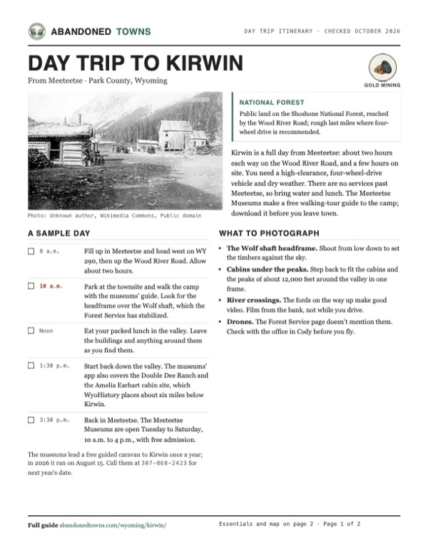
Mining companies spent between $1 million and $4 million here in the early 1900s. Around 1905 about 200 people lived in the camp, which had a hotel, a boarding house, two general stores, a sawmill, an assay shop and a post office, with a stage to Meeteetse every other day. The ore never paid for the long haul to market, and on February 5, 1907 an avalanche off Bald Mountain destroyed several buildings and killed three people. Most of the miners left, and the rest followed over the next few years.
In 1931 Carl Dunrud bought the land and opened the Double Dee Dude Ranch six miles down the valley. Amelia Earhart stayed there in 1934 and asked him to build her a cabin, which was still unfinished when she disappeared in 1937. After AMAX gave up on copper and molybdenum in the 1960s, conservation buyers gave the district to the Forest Service in 1992, and stabilization of the buildings began in 1999.
Timeline
From Spar Mountain to the Forest Service
- About 130 prospectors led by William Kuykendall reach the upper Wood River. Soldiers turn them out because the land falls under the 1868 treaty with the Shoshone. WyoHistory names Camp Brown; Wikipedia says Fort Bowman or possibly Camp Brown.
- William Kirwin and Harry Adams find gold and silver on Spar Mountain while deer hunting, and Adams spreads the word. Wikipedia dates the find to 1885.
- The Wood River Mining District is organized.
- The Shoshone Mining and Development Co., the Galena Ridge Mining Co. and the Wyoming Mining Company put between $1 million and $4 million into the district. Stagecoaches run to Meeteetse every other day.
- The peak: about 200 people, mostly miners and their families, with a hotel, a boarding house, two general stores, a sawmill, an assay shop and a post office.
- An avalanche off Bald Mountain destroys several buildings and kills three people. Many miners leave, and the rest drift away over the next years.
- Henry Schnitzel controls most of the land: about 3,300 acres and 144 patented mining claims.
- Carl Dunrud buys Schnitzel's holdings and opens the Double Dee Dude Ranch about six miles below Kirwin.
- Amelia Earhart and George Palmer Putnam visit the ranch in 1934 and ask Dunrud to build them a cabin. Work stops when Earhart disappears on her 1937 world flight.
- AMAX samples the district and finds copper and molybdenum, then drops its plans after public opposition and swings in ore prices.
- The Mellon Foundation and the Conservation Fund buy the AMAX holdings and give the Kirwin district and the Double Dee Ranch to the U.S. Forest Service.
- The Shoshone National Forest and its partners begin stabilizing the buildings, including the headframe over the Wolf shaft.
- The Meeteetse Museums lead their annual guided caravan to Kirwin.
What's left
Cabins in a high valley

Wikipedia says many of the 1904–1906 buildings still stand, and an undated listing names a church, cabins, gold shafts, work sheds and mining equipment. WyoHistory's photos show the Forest Service's work on the headframe over the Wolf shaft. We found no recent inventory of which buildings stand, so expect cabins and mine structures in varying states of repair. The Meeteetse Museums say there is a vault toilet at Kirwin. Leave the buildings and whatever lies around them as you find them.
The 1904 USGS sheet in the historic maps below marks Kirwin on the creek where Spar Creek comes in, between Mount Crosby to the west, Brown Mountain to the north and Dundee Mountain to the east, with Bald Mountain and Spar Mountain to the south. The 1969 sheet names the Mattice Tunnel, the Molly Logan Mine and the Wolf Shaft beside the town and a small pond on the valley floor.
- Cabins
- Church
- Work sheds
- Wolf shaft headframe
- Mine shafts and tunnels
- Mining equipment
- Vault toilet


Historic maps
Kirwin on USGS maps, 1904–1978
Crops from the USGS Historical Topographic Map Collection, centered on the townsite. Each sheet shows what surveyors mapped that year; compare them with today's topo and aerial on this page.

Day trip
Plan a day trip to Kirwin from Meeteetse
Take it with you
Day trip itinerary
The essentials, the sample day with boxes to tick, what to photograph and the coordinates, on two printable pages. Handy where there's no signal.
Download the PDF (617 KB)Kirwin is a full day from Meeteetse: about two hours each way on the Wood River Road, and a few hours on site. You need a high-clearance, four-wheel-drive vehicle and dry weather. There are no services past Meeteetse, so bring water and lunch. The Meeteetse Museums make a free walking-tour guide to the camp; download it before you leave town.
A sample day
- Fill up in Meeteetse and head west on WY 290, then up the Wood River Road. Allow about two hours.
- Park at the townsite and walk the camp with the museums' guide. Look for the headframe over the Wolf shaft, which the Forest Service has stabilized.
- Eat your packed lunch in the valley. Leave the buildings and anything around them as you find them.
- Start back down the valley. The museums' app also covers the Double Dee Ranch and the Amelia Earhart cabin site, which WyoHistory places about six miles below Kirwin.
- Back in Meeteetse. The Meeteetse Museums are open Tuesday to Saturday, 10 a.m. to 4 p.m., with free admission.
The museums lead a free guided caravan to Kirwin once a year; in 2026 it ran on August 15. Call them at 307-868-2423 for next year's date.
What to photograph and film
- The Wolf shaft headframe. Shoot from low down to set the timbers against the sky.
- Cabins under the peaks. Step back to fit the cabins and the peaks of about 12,000 feet around the valley in one frame.
- River crossings. The fords on the way up make good video. Film from the bank, not while you drive.
- Drones. The Forest Service page doesn't mention them. Check with the office in Cody before you fly.
Map & directions
Getting there
Meeteetse is the last town, 33.7 miles and about two hours away: WY 290 west, then 25.4 miles up the Wood River Road. The Forest Service gives the same two hours. From Cody, add the drive south on WY 120 to Meeteetse. The routes are computed from OpenStreetMap and haven't been driven by us. For the rough last miles and river crossings, the Forest Service recommends four-wheel drive and the Meeteetse Museums a high-clearance four-wheel-drive vehicle.


Base map: USGS The National Map (public domain). Routes: OSRM on © OpenStreetMap contributors data (ODbL), computed October 2026. Times assume dry roads.
- Leave Meeteetse on Park Avenue and Hayes Avenue (WY 290), which becomes Pitchfork Road.6.6 mi
- Turn left on the Wood River Road and follow the river up into the Shoshone National Forest.25.4 mi
- Turn left on the road OpenStreetMap names Wood River, to the townsite.1.7 mi
- From 16th Street, turn left on Beck Avenue and right on 17th Street, which becomes the Greybull Highway.2.2 mi
- Turn right on WY 120.29.2 mi
- Turn right on Park Avenue (WY 290) in Meeteetse and continue on Hayes Avenue and Pitchfork Road.6.6 mi
- Turn left on the Wood River Road.25.4 mi
- Turn left on the road OpenStreetMap names Wood River, to the townsite.1.7 mi
Road and safety notes
- The Forest Service (February 2025) calls Kirwin a two-hour drive on the Wood River Road from Meeteetse and recommends four-wheel drive for the rough last miles.
- The Meeteetse Museums (2026) advise a high-clearance four-wheel-drive vehicle and warn of several river crossings. WyoHistory says the trip is best made in dry weather.
- Vault toilets are at the Wood River and Brown Mountain campgrounds on the way, and at Kirwin.
- The Forest Service lists no potable water, and the Meeteetse Museums tell visitors to pack in water and pack out trash. Fill your tank in Meeteetse.
- Stay out of shafts and tunnels.
Photos
Kirwin in photos
Visitor reports
Been to Kirwin?
Been there lately? Tell the next visitor what you found: whether you could get in, the state of the road and what's still standing. Photos are welcome. We read every report before it appears here.
Gold mining
More gold mining ghost towns
The nearest in Wyoming.

 Guide
Atlantic City
42.50, -108.73Fremont County, Wyoming
Gold on Rock Creek drew some 2,000 people to Atlantic City in its first boom, from 1868. The boom lasted barely five years; dredges and an iron mine…
 Guide
South Pass City
42.47, -108.80Fremont County, Wyoming
A gold camp of 1867 at the south end of the Wind River Range, where the territory's women first voted and held office. The state keeps the town and…
Nearby
Other sites near Kirwin
Straight-line distance from the townsite to other mapped sites in our Wyoming index.
Sources
Sources and credits
- ghosttowns.com, "Kirwin": fact-sheet fields (roads, climate, best time, remains, population).
- Wikipedia, "Kirwin, Wyoming", retrieved October 2026: coordinates, station elevation and climate normals, the 1870 prospectors, the 1885 find, the 1891 district, the peak population and buildings, the February 5, 1907 avalanche, the 1992 donation and stabilization from 1999.
- Lori Van Pelt, "Kirwin Inspired Dreams of Prosperity, Solitude," WyoHistory.org, May 18, 2016: Camp Brown and the treaty, the find on Spar Mountain, investment, the stage, Schnitzel and Dunrud, the Double Dee, Earhart and Putnam, AMAX, the Mellon Foundation and Conservation Fund gift, the restoration partners and the Wolf shaft.
- WyoHistory.org, "Kirwin, Wyoming" field trip, read October 2026: 38 miles from Meeteetse, Forest Service Road 200, dry weather and four-wheel drive, the Cody office phone.
- U.S. Forest Service, Shoshone National Forest, "Meeteetse", updated February 18, 2025: two-hour drive on the Wood River Road, rough last miles, four-wheel drive recommended.
- Meeteetse Museums, "Guided Tour of Kirwin 2026", read October 2026: the August 15, 2026 tour, high-clearance four-wheel drive, river crossings, vault toilets.
- Meeteetse Museums, official site, and its Bloomberg Connects page, read October 21, 2026: museum hours and free admission, phone, the downloadable Kirwin, Double Dee and Amelia Earhart cabin site tours, no phone service on site. "The Mining Town of Kirwin Tour" (August 10, 2024): the tour's length, bear country and bear spray. For the day trip.
- Photos: Wikimedia Commons, credited below each one. Elevation: USGS 3D Elevation Program point query. Routes: OSRM on OpenStreetMap data, October 2026. Not field-checked.
Photo and map credits
- Kirwin on July 4, 1905: Unknown author, Wikimedia Commons, Public domain
- The Wolf shaft house, in an undated Forest Service photograph: Gordon Warren, Wikimedia Commons, Public domain
- Area base map, topo and aerial imagery: USGS The National Map (public domain).
- Historic maps: USGS Historical Topographic Map Collection (public domain): Kirwin 1904, 1:125,000; Francs Peak 1969, 1:24,000; The Ramshorn 1978, 1:100,000.