 Abandoned

Overview
A camp built for ten thousand people

Heart Mountain was one of ten camps the War Relocation Authority built in 1942 to hold Japanese Americans forced from the West Coast under Executive Order 9066. The site was Bureau of Reclamation land on the Shoshone irrigation project, on the bench between Cody and Powell, with Heart Mountain itself rising about 8 miles to the west. About 2,000 workers put up some 650 buildings in roughly two months: 20 residential blocks of tarpaper barracks, each block with its own mess hall, latrines and laundry, inside a fence of barbed wire watched from guard towers.
The first train arrived in August 1942. Most of the people on board came from Los Angeles County, with large groups from Santa Clara County, San Francisco and the Yakima Valley of Washington. Families lived in single rooms with a stove, one light and army cots. By January 1943 the camp held 10,767 people, which the Foundation says made it, unofficially, the third-largest community in Wyoming. Over three years, about 14,000 people passed through. They farmed, built the irrigation canal, ran schools, a hospital and a newspaper, and earned $12 to $19 a month.
Heart Mountain was also the center of organized resistance to the draft. When the Army began drafting Nisei men from the camps in 1944, the Fair Play Committee, organized by Kiyoshi Okamoto, protested that the draft violated the rights of men who were themselves confined. Sixty-three young men were tried together in Cheyenne and sent to prison; President Truman later pardoned them. At the same time, hundreds of men from the camp served in the Army, and two received the Medal of Honor. The last train left on November 10, 1945. Most of the land and barracks were sold to farmers and former servicemen.
Since 2011 the Heart Mountain Wyoming Foundation, set up in 1996 to preserve the site, has run an interpretive center on the site with exhibits, oral histories and a paved walking trail across the road from the surviving hospital buildings.
Timeline
August 1942 to November 1945


- President Franklin D. Roosevelt signs Executive Order 9066. About 120,000 people of Japanese ancestry are forced from their homes on the West Coast.
- Most of the people later sent to Heart Mountain are first held for three to four months at Santa Anita Racetrack, the Los Angeles County Fairgrounds or the livestock pavilion in Portland, Oregon.
- The Bureau of Reclamation hands 46,000 acres of its Shoshone Project land to the War Relocation Authority on June 1. About 2,000 workers build the camp in roughly 60 days.
- The first trainload of incarcerees arrives (the National Park Service gives August 11). The 150-bed hospital opens on August 28.
- Classes begin in barracks on October 5, and the camp newspaper, the Heart Mountain Sentinel, edited by Bill Hosokawa, first appears.
- About 3,000 people sign a petition against the barbed-wire fence. It goes up anyway and is finished in December.
- The population peaks at 10,767, which makes the camp, unofficially, the third-largest community in Wyoming.
- The high school building is finished.
- The draft is reinstated for Nisei men. The Heart Mountain Fair Play Committee organizes resistance; 85 men are arrested for refusing to report.
- Sixty-three resisters are tried together in Cheyenne, the largest mass trial in Wyoming history, and sentenced to federal prison. Seven Fair Play Committee leaders are convicted of conspiracy in November; their convictions are overturned in December 1945.
- Hundreds of men from the camp serve in the Army. Two, Joe Hayashi and James K. Okubo, later receive the Medal of Honor.
- The last train leaves. Departing incarcerees are given $25 and a ticket. The land and barracks are later sold to farmers and former servicemen.
- President Truman pardons the draft resisters (WyoHistory dates the pardon to 1946).
- The site is listed on the National Register of Historic Places on December 19, 1985, and becomes a National Historic Landmark (September 20, 2006, per the landmark record; Wikipedia's text says 2007).
- The Heart Mountain Wyoming Foundation, founded in 1996, opens the Heart Mountain Interpretive Center on the site.
What's left
The hospital chimney and the street grid

Most of the camp is gone. What the National Park Service lists at the site is the hospital complex: the boiler house and its tall red brick chimney, a warehouse and a mess hall, plus an administrative staff-housing unit. The Foundation adds a root cellar, an original barrack, the records vault of the high school and the remains of the swimming hole, and the old street grid and many foundations still show in the fields. A reproduction of the camp's Honor Roll, the memorial listing the men who served in the military, was finished in 2003.
The chimney is the landmark on the drive in: the Foundation tells visitors to look for it, and for two large trees, at the turn onto Road 19 from US 14A. The Setsuko Saito Higuchi Interpretive Trail, a quarter-mile paved path, starts above the interpretive center across the road from the hospital complex. Barrack-shaped sheds and barns along US 14A are camp buildings that were sold off after the war.
The 1955 USGS sheet in the historic maps below, made ten years after the camp closed, marks only "Warehouses" beside the railroad, with Heart Mountain to the west. The 1966 sheet shows the road through the old camp area, a handful of buildings by the tracks and the hamlet of Vocation to the southeast. By 1980 the sheet is a grid of farm roads and irrigation laterals, H-103 and H-105 among them.
- Hospital boiler house and red brick chimney
- Hospital warehouse and mess hall
- Administrative staff-housing unit
- Root cellar
- Original barrack
- High school records vault
- Honor Roll replica (2003)
- Street grid and foundations
- Interpretive center and trail


Historic maps
Heart Mountain on USGS maps, 1955–1980
Crops from the USGS Historical Topographic Map Collection, centered on the townsite. Each sheet shows what surveyors mapped that year; compare them with today's topo and aerial on this page.

Day trip
Plan a day trip to Heart Mountain from Cody
Take it with you
Day trip itinerary
The essentials, the sample day with boxes to tick, what to photograph and the coordinates, on two printable pages. Handy where there's no signal.
Download the PDF (551 KB)The interpretive center is 19 minutes from Cody, so a visit fits in a morning. Give the exhibits and oral histories time, then walk the short trail across the road from the hospital buildings. In winter the center opens only Wednesday to Saturday, so check the day before you go.
A sample day
- Leave Cody on US 14A. The drive is 13.5 miles, about 19 minutes. Turn at the brick chimney and two large trees onto Road 19.
- The interpretive center opens. Take an audio guide and give the exhibits and oral histories most of the morning.
- Walk the quarter-mile Setsuko Saito Higuchi Interpretive Trail, across the road from the hospital buildings and the chimney.
- Drive back along US 14A toward Cody or on to Powell for lunch. The Foundation notes that barrack-shaped sheds and barns along the highway are camp buildings sold after the war.
In winter the center is closed Sunday to Tuesday (and Wednesday from January 7 to March 30, 2027); the Foundation says it opens by appointment on closed days. Coming from Billings? The routed drive is 97.5 miles, about 1 h 55 min. The annual Pilgrimage is at the end of July; the 2027 dates are July 29 to 31.
What to photograph and film
- The hospital chimney. The tall brick stack is the landmark the Foundation tells drivers to look for at the Road 19 turn. It stands beside the boiler house.
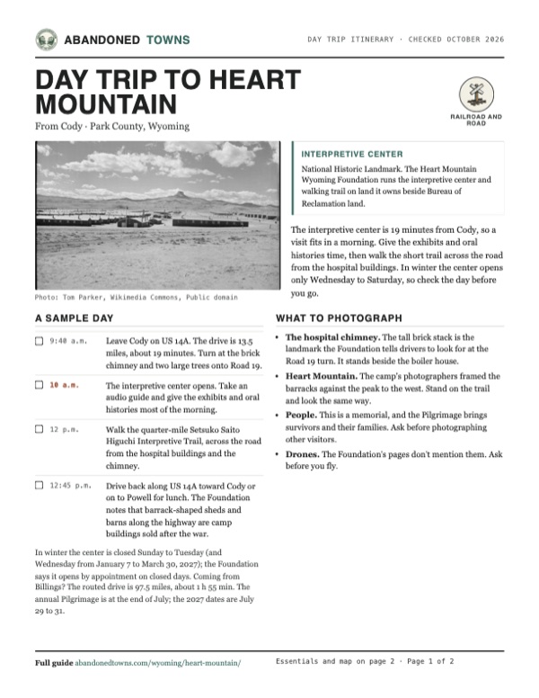
- Heart Mountain. The camp's photographers framed the barracks against the peak to the west. Stand on the trail and look the same way.
- People. This is a memorial, and the Pilgrimage brings survivors and their families. Ask before photographing other visitors.
- Drones. The Foundation's pages don't mention them. Ask before you fly.
Map & directions
Getting there
Cody is the closest city, 13.5 miles and about 19 minutes away on US 14A, the Powell Highway. From Billings, Montana, the routed drive comes south on US 310, MT 72 and WY 120, then crosses on WY 294 to US 14A. Both routes end on Road 19 about 150 meters from the mapped camp point; follow the Foundation's signs to the interpretive center's circular drive. The routes are computed from OpenStreetMap and haven't been driven by us.


Base map: USGS The National Map (public domain). Routes: OSRM on © OpenStreetMap contributors data (ODbL), computed October 2026. Times assume dry roads.
- From downtown Cody, take 16th Street (US 14A/WY 120), which becomes the Powell Highway (US 14A).13.1 mi
- Turn left on Road 19, at the brick chimney, to the interpretive center.0.4 mi
- From Montana Avenue, take North 23rd Street, 1st Avenue North and North 27th Street (MT 3) to the interstate.2.1 mi
- Merge onto I-90 (with US 212).15.4 mi
- Exit onto US 212, turn left on US 212/US 310, then left on Clarks River Road.10.9 mi
- Turn left back onto US 212/US 310, then left onto US 310.19.4 mi
- Bear right onto MT 72, which becomes the Belfry Highway (WY 120).28.4 mi
- Turn left on Badger Basin Road (WY 294) and follow WY 294.18.9 mi
- Turn right on the Powell Highway (US 14A).1.9 mi
- Turn right on Road 19.0.4 mi
Road and safety notes
- The routes are computed from OpenStreetMap and haven't been driven by us.
- The Foundation's directions: from US 14A, turn onto Road 19 at the red brick chimney and two large trees, then continue to the circular drive and parking lot.
- The interpretive center, the original barrack and the walking trail are wheelchair accessible, and manual wheelchairs can be borrowed inside.
- Pets may be walked on the grounds but are not allowed in the interpretive center; service animals are welcome.
Photos
Heart Mountain in photos
Visitor reports
Been to Heart Mountain?
Been there lately? Tell the next visitor what you found: whether you could get in, the state of the road and what's still standing. Photos are welcome. We read every report before it appears here.
Railroad and road
More railroad, road and fort ghost towns
The nearest in Wyoming.

 Guide
Point of Rocks
41.68, -108.79Sweetwater County, Wyoming
A stage stop of 1862 on the Overland Trail where the Union Pacific arrived in 1868, and a starting point for the road to the South Pass gold camps.…
 Guide
Fort Fred Steele
41.78, -106.95Carbon County, Wyoming
An Army post built in 1868 to guard the Union Pacific bridge over the North Platte. After the soldiers left in 1886 it lived on as a tie, sheep and…
Nearby
Other sites near Heart Mountain
Straight-line distance from the townsite to other mapped sites in our Wyoming index.
Sources
Sources and credits
- Heart Mountain Wyoming Foundation, "Visit", read October 20, 2026: winter 2026–27 and summer 2027 hours, admission, address, phone, directions and the chimney landmark.
- Heart Mountain Wyoming Foundation, "History", read October 20, 2026: Executive Order 9066, the assembly centers, construction, arrivals and origins, the fence petition, the hospital, the Sentinel, schools, wages, the peak of 10,767, the draft and the 63 resisters, the pardon, military service, the last train, the land sales and the barracks along US 14A.
- "Landmarks & Original Structures" and "Accessibility", Heart Mountain Wyoming Foundation, read October 20, 2026: surviving structures, the quarter-mile Setsuko Saito Higuchi Interpretive Trail, wheelchairs, audio guides and pets. "Pilgrimage": the 2027 Pilgrimage, July 29–31.
- Wikipedia, "Heart Mountain Relocation Center", retrieved October 2026: coordinates, the June 1, 1942 land transfer, 13,997 people held, the Fair Play Committee, the Medal of Honor recipients, the Honor Roll replica, the Foundation and the 2011 opening, National Register and landmark dates, and land ownership.
- Steven Bingo, "A Brief History of Heart Mountain Relocation Center," WyoHistory.org, November 8, 2014: arrival and departure dates, the fence, the mass trial in Cheyenne, the seven leaders, the 1946 pardon date, 385 men inducted.
- National Park Service, "Heart Mountain Relocation Center", updated May 29, 2018: the four surviving hospital-complex buildings, first arrivals on August 11, 1942, distances from Cody and Powell, the mountain 8 miles west.
- ghosttowns.com, "Heart Mountain": fact-sheet fields (roads, climate, best time).
- Photos: Wikimedia Commons, credited below each one. Elevation: USGS 3D Elevation Program point query. Routes: OSRM on OpenStreetMap data, October 2026. Not field-checked.
Photo and map credits
- Barracks below Heart Mountain, looking west, September 18, 1942: Tom Parker, Wikimedia Commons, Public domain
- The hospital boiler house and chimney, July 2025: Stan ralphly, Wikimedia Commons, CC BY-SA 4.0
- F Street, the camp's main road, looking west toward Heart Mountain, September 1942: Tom Parker, Wikimedia Commons, Public domain
- The mess hall of the camp hospital, newly finished and empty, September 2, 1942: U.S. Army Engineers, Wikimedia Commons, Public domain
- Looking east over the camp from Reservoir Hill, September 16, 1942: Tom Parker, Wikimedia Commons, Public domain
- Unloading crates of belongings at a barrack, September 1942: Tom Parker, Wikimedia Commons, Public domain
- Barrack lights at dusk, September 1942: Tom Parker, Wikimedia Commons, Public domain
- Folding the Heart Mountain Sentinel, January 8, 1943: Tom Parker, Wikimedia Commons, Public domain
- Cleared farmland beside uncleared sagebrush, March 10, 1944: Hikaru Iwasaki, Wikimedia Commons, Public domain
- Area base map, topo and aerial imagery: USGS The National Map (public domain).
- Historic maps: USGS Historical Topographic Map Collection (public domain): Cody 1955, 1:250,000; Vocation 1966, 1:24,000; Powell 1980, 1:100,000.