 Abandoned

Overview
A camp that left its post office behind

American Flag was a small mining camp at the northern foot of the Santa Catalina Mountains, about five miles southeast of Oracle. Its founder, Isaac Lorraine, located the American Flag gold and silver mine in the late 1870s. The Oracle Historical Society spells his name Laurin and says he came from Martinique. Around 1877 he built an adobe house that served as his home and as headquarters for his mining and ranching.
In December 1880 that house became the first post office in the district. The camp itself stayed tiny. It had about 40 people at most and fell to about 15, and little is recorded about it after 1884. By one account the mine was sold to the Richardson Mining Company of New York in 1881. Over the 1880s people drifted toward Oracle, and the post office closed in July 1890.
The adobe outlasted the camp. It's believed to be the oldest territorial post office building still standing in Arizona, and it has been on the National Register of Historic Places since 1979. The Oracle Historical Society has owned it since 1999. Volunteers restored the house, barn and corrals between 2011 and 2015, and the society now opens it by appointment. The Arizona Trail passes right by.
Timeline
From mining camp to museum


- Isaac Lorraine (Laurin in the Oracle Historical Society's history) works claims here, including the American Flag mine and mill site. He and others organize the Old Hat Mining District.
- Lorraine builds an adobe ranch house as his home and headquarters.
- The house becomes the first post office in the district. Wikipedia and an undated listing give December 28; the plaque on the house says December 20.
- The mine is sold to the Richardson Mining Company of New York, according to a 1969 history quoted by Wikipedia.
- The camp peaks at about 40 people and falls to about 15. Little is recorded about it after 1884.
- With most people now around Oracle, mail service at American Flag ends.
- Owner Thelma Rowe donates the ranch house and barn to the Arizona Historical Society.
- The American Flag Post Office Ranch is listed on the National Register of Historic Places.
- The Arizona Historical Society deeds the property to the Oracle Historical Society.
- The Oracle Historical Society begins a restoration of the house, barn and corrals that takes more than four years.
- The ranch reopens with a celebration, as a small museum.
- The house is open by appointment. The Arizona Trail's American Flag Trailhead is beside it.
What's left
One adobe, a barn and the corrals


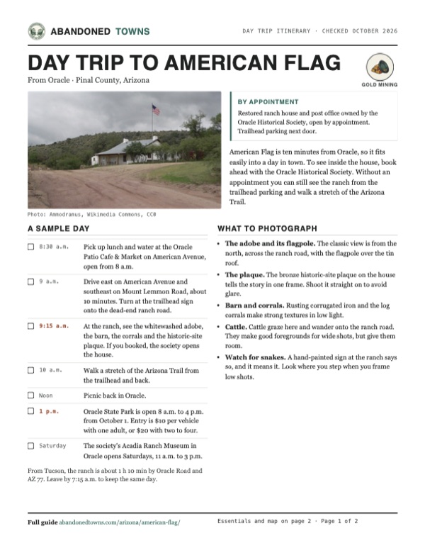
Nothing of the mining camp is described as surviving. What stands is the ranch: the long, whitewashed adobe house with its tin roof and front porch, a corrugated-iron barn, log corrals and a water tank. A bronze plaque from the Oracle and Arizona historical societies on the house tells its story. Restoration volunteers led by Kevin Armbrust repaired the buildings between 2011 and 2015.
The house sits on Flag Wash below American Flag Hill, just west of Mount Lemmon Road. The historic maps below show the setting. The 1911 Winkelman sheet doesn't name the ranch, but it shows roads meeting here, Oracle to the northwest, and Campo Bonito with the Bonito and Southern Belle mines to the southwest. The 1948 Campo Bonito sheet labels American Flag Ranch beside the road, at the edge of Coronado National Forest, and the 1951 Mammoth sheet shows the ranch on the Mount Lemmon road with the Highjinks Mine, Campo Bonito and the Bonito Mine in the hills to the southwest.
- Adobe ranch house and post office (about 1877, restored)
- Barn
- Corrals
- Water tank
- Historic-site plaque


Historic maps
American Flag on USGS maps, 1911–1996
Crops from the USGS Historical Topographic Map Collection, centered on the townsite. Each sheet shows what surveyors mapped that year; compare them with today's topo and aerial on this page.

Day trip
Plan a day trip to American Flag from Oracle
Take it with you
Day trip itinerary
The essentials, the sample day with boxes to tick, what to photograph and the coordinates, on two printable pages. Handy where there's no signal.
Download the PDF (511 KB)American Flag is ten minutes from Oracle, so it fits easily into a day in town. To see inside the house, book ahead with the Oracle Historical Society. Without an appointment you can still see the ranch from the trailhead parking and walk a stretch of the Arizona Trail.
A sample day
- Pick up lunch and water at the Oracle Patio Cafe & Market on American Avenue, open from 8 a.m.
- Drive east on American Avenue and southeast on Mount Lemmon Road, about 10 minutes. Turn at the trailhead sign onto the dead-end ranch road.
- At the ranch, see the whitewashed adobe, the barn, the corrals and the historic-site plaque. If you booked, the society opens the house.
- Walk a stretch of the Arizona Trail from the trailhead and back.
- Picnic back in Oracle.
- Oracle State Park is open 8 a.m. to 4 p.m. from October 1. Entry is $10 per vehicle with one adult, or $20 with two to four.
- The society's Acadia Ranch Museum in Oracle opens Saturdays, 11 a.m. to 3 p.m.
From Tucson, the ranch is about 1 h 10 min by Oracle Road and AZ 77. Leave by 7:15 a.m. to keep the same day.
What to photograph and film
- The adobe and its flagpole. The classic view is from the north, across the ranch road, with the flagpole over the tin roof.
- The plaque. The bronze historic-site plaque on the house tells the story in one frame. Shoot it straight on to avoid glare.
- Barn and corrals. Rusting corrugated iron and the log corrals make strong textures in low light.
- Cattle. Cattle graze here and wander onto the ranch road. They make good foregrounds for wide shots, but give them room.
- Watch for snakes. A hand-painted sign at the ranch says so, and it means it. Look where you step when you frame low shots.
Map & directions
Getting there
Oracle is the closest town, about 10 minutes away on paved road almost to the door. From Tucson, the route runs north on Oracle Road and AZ 77 to Oracle, then southeast on Mount Lemmon Road. The ranch is also the American Flag Trailhead of the Arizona Trail.


Base map: USGS The National Map (public domain). Routes: OSRM on © OpenStreetMap contributors data (ODbL), computed October 2026. Times assume dry roads.
- From downtown Oracle, head east on East American Avenue.0.3 mi
- Turn right on East Mount Lemmon Highway. Follow it southeast as it becomes Mount Lemmon Highway and then South Mount Lemmon Road.3.9 mi
- Continue onto Control Road (Forest Road 38), unpaved, to the ranch and trailhead.0.3 mi
- From downtown Tucson, take Congress Street, Granada Avenue and Main Avenue north to Oracle Road.1.4 mi
- Follow Oracle Road north out of the city. It becomes AZ 77, the Tucson–Globe Highway.32 mi
- Continue onto West American Avenue into Oracle.2.3 mi
- Turn right on East Mount Lemmon Highway, which becomes South Mount Lemmon Road, then continue onto Control Road (Forest Road 38) to the ranch.4.2 mi
Road and safety notes
- OpenStreetMap tags American Avenue and Mount Lemmon Road as asphalt. Only the last 0.3 mile, on Control Road, is unpaved. An undated listing rates the drive 2WD.
- The Arizona Trail Association's directions turn west off Mount Lemmon Road onto American Flag Ranch Road, a dead end, 4 miles from American Avenue. OpenStreetMap names the last stretch Control Road. The trailhead isn't visible from Mount Lemmon Road, so watch for the sign.
- Trailheads sit on both sides of the ranch road, and parking is near the historic ranch. Passage 12 of the Arizona Trail arrives from the west and Passage 13 starts on the east side.
- The house is open by appointment only. Contact the Oracle Historical Society ahead of time to see inside, and respect the fences around the buildings.
- Summers are hot. Fall and winter are the best times to visit.
Photos
American Flag in photos
Visitor reports
Been to American Flag?
Been there lately? Tell the next visitor what you found: whether you could get in, the state of the road and what's still standing. Photos are welcome. We read every report before it appears here.
Gold mining
More gold mining ghost towns
The nearest in Arizona.

 Guide
Greaterville
31.76, -110.75Pima County, Arizona
A placer gold camp from 1874, where water was so scarce it came in on burros. The townsite is private land now, and a forest road crosses it on the…
 Guide
Kentucky Camp
31.74, -110.74Pima County, Arizona
The adobe headquarters of a hydraulic gold-mining venture that lasted about four years. The Forest Service restored it, and it's open year-round with…
Nearby
Other sites near American Flag
Straight-line distance from the townsite to other mapped sites in our Arizona index.
Sources
Sources and credits
- ghosttowns.com, "American Flag": fact sheet fields (roads, legal description, climate, best time, remains, post office dates, population).
- Wikipedia, "American Flag, Arizona", retrieved October 2026: founder, 1881 sale to the Richardson Mining Company (citing Sherman and Sherman, Ghost Towns of Arizona, 1969), population, coordinates and elevation (GNIS).
- Wikipedia, "National Register of Historic Places listings in Pinal County, Arizona": listing date (June 20, 1979), reference number 79000426 and coordinates.
- Oracle Historical Society, "American Flag Ranch", as of October 2026: Isaac Laurin, the Old Hat Mining District, the 1877 house, ownership since the 1970s, the 2011–2015 restoration, the September 2015 reopening and appointment-only visits.
- Historic-site plaque by the Oracle and Arizona historical societies on the ranch house, as photographed for Wikimedia Commons in 2019: house built about 1877, post office opened December 20, 1880, mail service ended July 16, 1890.
- Arizona Trail Association, Passage 12 and "Gateway: Oracle" (pages with 2026 updates): trailhead directions, parking by the ranch, the passages that meet here.
- Oracle Historical Society, "American Flag Ranch", contact page and home page, as of October 2026: appointments, phone and email, Acadia Ranch Museum hours.
- Arizona Trail Association, Passage 12 and Passage 13, as of October 2026: trailhead parking, the dead-end road and sign.
- Oracle Community Center, town directory, with Oracle Patio Cafe & Market and Nonna Maria's Pizza: places to eat and their hours, as of October 2026.
- Arizona State Parks, Oracle State Park: winter hours and fees, as of October 2026.
- Road surfaces: OpenStreetMap, October 2026. Routes: OSRM on OpenStreetMap data, October 2026. Status checked against the sources above on October 19, 2026.
Photo and map credits
- The ranch house from the north, 2013: Ammodramus, Wikimedia Commons, CC0
- The front porch, 2013: Ammodramus, Wikimedia Commons, CC0
- The house behind its horseshoe fence, 2019: Marine 69-71, Wikimedia Commons, CC BY-SA 4.0
- From the southeast, 2013: Ammodramus, Wikimedia Commons, CC0
- The historic-site plaque, 2019: Marine 69-71, Wikimedia Commons, CC BY-SA 4.0
- The ranch from the hills to the northwest, 2013: Ammodramus, Wikimedia Commons, CC0
- The corrals, 2019: Marine 69-71, Wikimedia Commons, CC BY-SA 4.0
- The barn, 2019: Marine 69-71, Wikimedia Commons, CC BY-SA 4.0
- Cattle on the ranch road, 2019: Marine 69-71, Wikimedia Commons, CC BY-SA 4.0
- A hand-painted warning at the ranch, 2019: Marine 69-71, Wikimedia Commons, CC BY-SA 4.0
- Area base map, topo and aerial imagery: USGS The National Map (public domain).
- Historic maps: USGS Historical Topographic Map Collection (public domain): Winkelman 1911, 1:125,000; Campo Bonito 1948, 1:24,000; Mammoth 1951, 1:62,500; Mammoth 1986, 1:100,000; Campo Bonito 1996, 1:24,000.