 Abandoned

Overview
A smelter town in the Buckskin Mountains

Swansea sits in the desert hills of La Paz County, about 25 miles by road from both Parker and Bouse. It was a copper town, and for a few years a lively one, with electric lights, a car dealer, a lumber company, saloons, theaters, restaurants, barbershops, a doctor and two cemeteries. Today the Bureau of Land Management looks after the ruins, and there are a few free campsites beside them.
Prospectors found copper here around 1862, but nothing much happened until a railroad was built toward Parker after 1904. Newton Evans and Thomas Jefferson Carrigan raised money, and by the end of 1908 a 350-ton furnace, a pipeline to water from the Bill Williams River and hoists over the shafts were under construction. The camp was first called Signal. It took the name Swansea after the smelting city in Wales where ore from the area had been shipped, by rail to the Colorado River and then by sea around Cape Horn. A short railroad tied it to the main line at Bouse.
The boom was short. George Mitchell, who promoted the Clara Consolidated Gold and Copper Mining Company, spent heavily on improvements that impressed investors and too little on mining and hauling. Costs ran three cents a pound above the price of copper, and the company collapsed in 1912. The American Smelting and Refining Company bought the mines in 1914 and rebuilt the town, but copper prices fell after World War I. The post office closed in 1924, and the mines shut down for good in 1937.
Timeline
Thirty years of copper


- Prospectors find copper and silver in the hills. The district is too remote to develop.
- Work starts on a railroad from Wickenburg to Parker, bringing rails close to the district.
- Newton Evans and Thomas J. Carrigan's claims are consolidated under the Clara company. By year's end a 350-ton furnace, a 3.5-mile water pipeline and mine hoists are going up. The camp is called Signal.
- The Arizona and Swansea Railroad links the camp to the main line at Bouse. Sources date it from 1908 to 1910.
- The post office opens under the new name, Swansea, after the Welsh smelting city. BLM puts the population at about 500.
- The census counts 400 people.
- The Clara Consolidated Gold and Copper Mining Company runs out of money. The mines close, reopen briefly in 1912 and close again.
- The American Smelting and Refining Company buys the mines and rebuilds much of the town.
- The census counts 337. Copper prices fall after World War I and the town declines.
- The post office closes.
- The mines shut down for good.
- A windstorm blows down the smelter's brick dust chamber, long the town's landmark.
- BLM has put tin roofs on the adobe miners' quarters, repaired the depot and laid out an interpretive trail.
- BLM photographs the company store, office, mess hall, cottages, smelter and mine shafts for its public photo set.
What's left
Adobe under tin roofs


BLM's September 2025 photos show the walls of the company store, the company office and the mess hall, rows of adobe worker cottages under new tin roofs, the smelter and ore-processing areas, and several mine shafts. Some shafts are covered with welded grates. Others are open, and some go down more than 1,000 feet. The railroad depot, many foundations, the old rail grade and two cemeteries complete the site. The smelter's tall brick dust chamber, once the town's trademark, blew down in a 1993 windstorm.
The campsites at the townsite each have a picnic table under a shade roof and a fire ring, and a vault toilet nearby. Collecting artifacts and metal detecting are not allowed.
The historic maps below show the town's arc. On the 1923 Signal sheet Swansea is a named stop on the railroad from Bouse, with the camp of Planet to the northwest. By 1966 it is marked Swansea (Site), with two cemeteries, a scatter of buildings and a natural arch to the southwest, which today's topo calls Miners Arch. The 1990 sheet labels the mine shafts and the old railroad grade. The peak east of town is Carrigan Peak on the 1923 and 1942 sheets and Clara Peak on the 1979 sheet, names shared with one of the camp's founders and its first mining company.
- Company store ruins
- Company office
- Mess hall
- Adobe worker cottages (re-roofed)
- Smelter and ore-processing areas
- Railroad depot
- Railroad grade to Bouse
- Two cemeteries
- Mine shafts (dangerous)


Historic maps
Swansea on USGS maps, 1923–1990
Crops from the USGS Historical Topographic Map Collection, centered on the townsite. Each sheet shows what surveyors mapped that year; compare them with today's topo and aerial on this page.
Day trip
Plan a day trip to Swansea from Parker
Take it with you
Day trip itinerary
The essentials, the sample day with boxes to tick, what to photograph and the coordinates, on two printable pages. Handy where there's no signal.
Download the PDF (589 KB)Swansea takes a full day from Parker, and most of it is the drive. The townsite has no water, food or fuel, so fill up in Parker and pack lunch and plenty of water. Campers can stay overnight at the townsite's designated sites and walk the ruins in the cool of the morning.
A sample day
- Leave Parker with a full tank and plenty of water. Take AZ 95 south and turn east on Shea Road. The computed drive is about 4 h 50 min because it treats the gravel as a slow track. A camper reported nearly two hours on a freshly rutted road, so you'll likely arrive well before noon.
- Arrive at the townsite. Start with the row of adobe worker cottages under their tin roofs, then the walls of the company store, office and mess hall.
- Eat a packed lunch at a shaded picnic table, if a campsite is free.
- Walk out to the smelter and ore-processing areas and the two cemeteries. Keep well back from the mine shafts.
- Start back, aiming to be off the gravel before dark. On the computed time you'd reach Parker about 7:20 p.m.; at the camper's pace, closer to 4:30 p.m.
- Tierra Caliente on Joshua Avenue in Parker is a Latin American restaurant and meat market, open 8 a.m. to 8 p.m. every day.
From Phoenix, BLM's way in is through Bouse, described in the road notes below. We haven't computed a time for it.
What to photograph and film
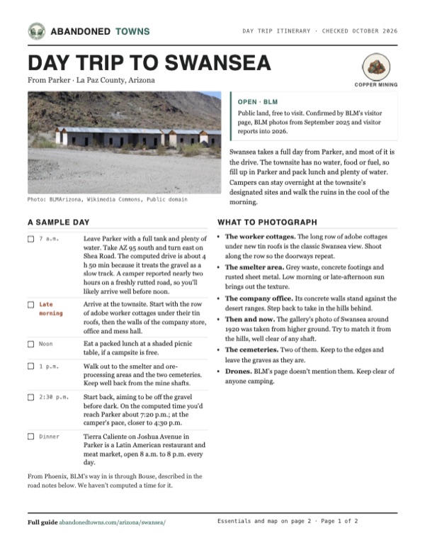
- The worker cottages. The long row of adobe cottages under new tin roofs is the classic Swansea view. Shoot along the row so the doorways repeat.
- The smelter area. Grey waste, concrete footings and rusted sheet metal. Low morning or late-afternoon sun brings out the texture.
- The company office. Its concrete walls stand against the desert ranges. Step back to take in the hills behind.
- Then and now. The gallery's photo of Swansea around 1920 was taken from higher ground. Try to match it from the hills, well clear of any shaft.
- The cemeteries. Two of them. Keep to the edges and leave the graves as they are.
- Drones. BLM's page doesn't mention them. Keep clear of anyone camping.
Map & directions
Getting there
Parker is the closest town with services. Lake Havasu City, home of the BLM field office, is about 40 miles farther north, and both routes leave Parker on Shea Road. The pavement ends after Shea Road, and the last 17 miles are graded gravel. BLM calls it about 25 miles from Parker; our route from downtown measures about 33. The computed times are far too long, because the routing treats the gravel as a slow track. One camper reported nearly two hours from Parker on a freshly rutted road.


Base map: USGS The National Map (public domain). Routes: OSRM on © OpenStreetMap contributors data (ODbL), computed October 2026. Times assume dry roads.
- From downtown Parker, follow California Avenue (AZ 95) south out of town.1.5 mi
- Turn left onto Shea Road and follow it east. BLM says it's paved for about 13 miles.13.9 mi
- Turn right, then bear right onto Swansea Mine Road, graded gravel. BLM says the turn is marked by a county sign.14.4 mi
- Continue on Swansea Road. Near the end, bear right onto Old Swansea Road and rejoin Swansea Road at the townsite.2.7 mi
- Take Smoketree Avenue and Acoma Boulevard to AZ 95 and follow it south along the Colorado River into Parker, staying on AZ 95 through town.40.1 mi
- In Parker, turn left onto Shea Road and follow it east.13.9 mi
- Turn right, then bear right onto Swansea Mine Road, graded gravel.14.4 mi
- Continue on Swansea Road, keeping right at the fork with Old Swansea Road, to the townsite.2.7 mi
Road and safety notes
- BLM recommends a high-clearance vehicle. Four-wheel drive isn't needed, but the last miles are rough and cross several washes, which can be worse after rain.
- From Phoenix, BLM and older guides describe the approach through Bouse: leave I-10 at Vicksburg Road and go north to AZ 72 and Bouse. From Bouse the road bends north and turns to gravel. Keep left at the first fork about 3 miles out, cross the CAP canal, keep left about 5 miles later at the fork with a bulletin board (Midway), then go about 10 more miles to a four-way stop and turn right into Swansea. We haven't drawn this route because the map data doesn't connect it.
- There's no water or fuel at the site. Fill up in Parker or Bouse and carry plenty of water.
- Cell service is patchy, with a bar or two in a few spots.
- Off-road races and dune buggies use these roads. Expect traffic and ruts around race weekends.
- Keep well away from mine shafts. Summer heat is severe, so go between fall and spring.
Photos
Swansea in photos
Visitor reports
Been to Swansea?
Been there lately? Tell the next visitor what you found: whether you could get in, the state of the road and what's still standing. Photos are welcome. We read every report before it appears here.
Copper mining
More copper mining ghost towns
The nearest in Arizona.

 Guide
Aubrey Landing
34.30, -114.13Mohave County, Arizona
A Civil War–era steamboat landing and mining supply town where the Bill Williams River met the Colorado. It was abandoned in the 1880s, and Lake…
 Guide
Briggs
34.06, -112.48Yavapai County, Arizona
Two tries at copper mining on Castle Creek, in the early 1880s and again in 1890, left a pair of camp names on the map. The way in is a 4WD creek-bed…
Nearby
Other sites near Swansea
Straight-line distance from the townsite to other mapped sites in our Arizona index.
- Planet8.7 mi NW · La Paz
- Bouse14.3 mi SW · La Paz
- Alamo Crossing16.3 mi NE · Mohave
- Aubrey Landing18.9 mi NW · Mohave
- Empire Flat20.2 mi W · La Paz
- Signal24.3 mi NE · Mohave
- Greenwood27.4 mi NE · Mohave
- Poston34.2 mi W · La Paz
Sources
Sources and credits
- ghosttowns.com, "Swansea": fact sheet fields (county, roads, legal description, climate, best time, remains, post office dates, the 750 population figure, race traffic).
- Wikipedia, "Swansea, Arizona", retrieved October 2026: Signal and the renaming, ore shipped to Wales, Mitchell and the Clara company, 1912 collapse, ASARCO, census counts, town amenities, BLM restoration, remains, coordinates and elevation (GNIS).
- Bureau of Land Management, "Swansea Historic Ghost Town", as of October 2026: directions from Parker and Bouse, vehicle advice, no fee, mine shaft warning, 1904 railroad, 1908 construction, 1909 population, 1911–1914 events, 1937 closure, field office contact.
- Bureau of Land Management, "Establishment of Supplementary Rules for the Parker Strip Recreation Area, Swansea Townsite …," Federal Register, October 12, 1995: Swansea Townsite rules on vehicles, camping, wood, artifacts, walls and structures, and fires.
- Parker Regional Chamber of Commerce, "Tierra Caliente Meat Market, Restaurant and Catering": address and hours, as of October 2026.
- BLM Arizona photo set, September 2025 (via Wikimedia Commons): current condition of the store, office, mess hall, cottages, smelter and shafts.
- azghosttowns.com, "Swansea": 1993 loss of the dust chamber, BLM roof and depot repairs, no collecting or metal detecting, deep shafts, the Phoenix approach via Bouse, the natural arch.
- The Dyrt, Swansea Ghost Town reviews, 2021 to January 2026: campsites, vault toilet, cell service, road experience and drive time.
- Destination4x4 (May 2026): cross-check of the Signal name, pipeline and smelter dates, and high-clearance advice.
- Coordinates: USGS GNIS (feature 24636). Elevation: USGS 3D Elevation Program point query. Routes: OSRM on OpenStreetMap data, October 2026. Status checked against the sources above on October 19, 2026.
Photo and map credits
- Worker cottages under new tin roofs, 2025: BLMArizona, Wikimedia Commons, Public domain
- Foundations of the company store, 2025: BLMArizona, Wikimedia Commons, Public domain
- Concrete walls of the company office, 2025: BLMArizona, Wikimedia Commons, Public domain
- Adobe walls of worker housing, 2025: BLMArizona, Wikimedia Commons, Public domain
- Ruins of the mess hall, 2025: BLMArizona, Wikimedia Commons, Public domain
- The smelting area, 2025: BLMArizona, Wikimedia Commons, Public domain
- The ore processing area, 2025: BLMArizona, Wikimedia Commons, Public domain
- A steel grate over a mine shaft, 2025: BLMArizona, Wikimedia Commons, Public domain
- A shaded campsite at the townsite, 2025: BLMArizona, Wikimedia Commons, Public domain
- The road in, 2025: BLMArizona, Wikimedia Commons, Public domain
- Swansea around 1920, with the smelter stacks at right: Bureau of Land Management, Wikimedia Commons, Public domain
- Desert ranges from the townsite, 2025: BLMArizona, Wikimedia Commons, Public domain
- The 1923 Signal sheet: Swansea on its railroad from Bouse: U.S. Geological Survey, USGS catalog, Public domain
- Topo map, area base map and aerial imagery: USGS The National Map (public domain).
- Historic maps: USGS Historical Topographic Map Collection (public domain): Signal 1923, 1:250,000; Signal 1942, 1:250,000; Swansea 1966, 1:62,500; Alamo Lake 1979, 1:100,000; Swansea 1990, 1:24,000.