 Abandoned

Overview
The silver that fed Los Angeles

The name is Spanish for "fat hill." Pablo Flores found silver here in 1865, high on the Inyo Mountains above Owens Lake, and by 1869 Cerro Gordo was the largest producer of silver and lead in the country. Mule teams hauled its output 275 miles to Los Angeles. In 1872 the Los Angeles News called the trade "the silver cord that binds our present existence."
Mortimer Belshaw arrived in 1868. He built a better smelter and the first wagon road up the mountain, the Yellow Road, and the tolls on it let him control shipments of silver off the mountain. The camp was lawless, and gunfights were recorded. By 1875 the ore was running short, and after a fire burned much of the mine works by 1877 and metal prices fell, most people left. A zinc revival after 1905 brought a second, smaller life.
In 2018 Brent Underwood and Jon Bier bought the 336-acre town for $1.4 million. In June 2020 a fire destroyed the 1871 American Hotel, and the frame of a replacement was finished in 2025. The owners now open the town free every day.
Video
Cerro Gordo in 30 seconds
The silver camp above Owens Lake: its mines in 1980, the view west to Owens Valley, the town in 2005 and its main street today.
Timeline
Silver, lead, then zinc

- Pablo Flores finds silver on the slopes of the Inyo Mountains above Owens Lake. Mining starts that year.
- The Lone Pine Mining District is organized. Victor Beaudry opens a store and buys into several claims.
- Mortimer Belshaw arrives, brings the first wagonload of silver to Los Angeles, builds a better smelter and the toll wagon road known as the Yellow Road.
- Cerro Gordo is the largest producer of silver and lead in the country. Mule teams haul its output 275 miles to Los Angeles.
- The American Hotel is built.
- Ore shortages and a failing water supply shut the furnaces down. A fire burns much of the mine works by 1877, lead and silver prices fall, and most people leave.
- A new owner buys the property and plans a 100-ton smelter.
- High-grade zinc has been found in the old stopes. The mine goes on to become the country's largest producer of zinc carbonates.
- Gross production since the early years reaches about $17 million.
- Brent Underwood and Jon Bier, with investors, buy the 336-acre town for $1.4 million.
- Fire destroys the American Hotel, an icehouse and a house.
- The frame of a new American Hotel is finished.
What's left
What you'll see


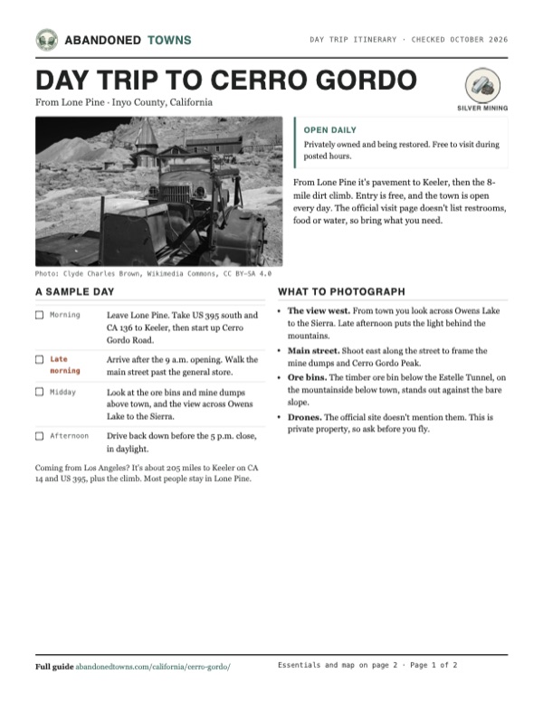
The town sits at about 8,130 feet, with the mine dumps above it and a long view west across Owens Lake to the Sierra. The 2018 sale included several old buildings, among them the general store. The American Hotel burned in 2020 and is being rebuilt. Ore bins and mine buildings stand on the slopes around town.
The 1913 USGS sheet in the next section marks the Cerro Gordo Mine at the top of a winding road from Keeler, a tramway running down toward Keeler, and Owens Lake still full of water.
- General store
- American Hotel (rebuilding)
- Ore bins
- Mine buildings and dumps
- Houses


Historic maps
Cerro Gordo on USGS maps, 1913–1985
Crops from the USGS Historical Topographic Map Collection, centered on the townsite. Each sheet shows what surveyors mapped that year; compare them with today's topo and aerial on this page.

Day trip
Plan a day trip to Cerro Gordo from Lone Pine
Take it with you
Day trip itinerary
The essentials, the sample day with boxes to tick, what to photograph and the coordinates, on two printable pages. Handy where there's no signal.
Download the PDF (578 KB)From Lone Pine it's pavement to Keeler, then the 8-mile dirt climb. Entry is free, and the town is open every day. The official visit page doesn't list restrooms, food or water, so bring what you need.
A sample day
- Leave Lone Pine. Take US 395 south and CA 136 to Keeler, then start up Cerro Gordo Road.
- Arrive after the 9 a.m. opening. Walk the main street past the general store.
- Look at the ore bins and mine dumps above town, and the view across Owens Lake to the Sierra.
- Drive back down before the 5 p.m. close, in daylight.
Coming from Los Angeles? It's about 205 miles to Keeler on CA 14 and US 395, plus the climb. Most people stay in Lone Pine.
What to photograph and film
- The view west. From town you look across Owens Lake to the Sierra. Late afternoon puts the light behind the mountains.
- Main street. Shoot east along the street to frame the mine dumps and Cerro Gordo Peak.
- Ore bins. The timber ore bin below the Estelle Tunnel, on the mountainside below town, stands out against the bare slope.
- Drones. The official site doesn't mention them. This is private property, so ask before you fly.
Map & directions
Getting there
Lone Pine is the nearest town. Drive south on US 395 and east on CA 136 to Keeler, on the shore of the dry Owens Lake. Cerro Gordo Road climbs from there: 8 miles of dirt, and the owners recommend 4WD. The router can't follow the dirt road, so the routes below stop at its foot.


Base map: USGS The National Map (public domain). Routes: OSRM on © OpenStreetMap contributors data (ODbL), computed October 2026. Times assume dry roads.
- Head south on South Main Street, US 395.1.9 mi
- Turn left onto CA 136 and follow it to Keeler.12.7 mi
- Turn onto Cerro Gordo Road and climb the dirt road to the town.8 mi
- From downtown, take US 101 and I-5 north, then CA 14, the Aerospace Highway, toward Mojave.144 mi
- Continue north on US 395.38 mi
- Turn right on CA 190, then left on CA 136 to Keeler.23 mi
- Turn onto Cerro Gordo Road and climb the dirt road to the town.8 mi
Road and safety notes
- Cerro Gordo Road is 8 miles of dirt with a steep climb. The owners recommend a 4WD vehicle; Wikipedia's account says 2WD can make it.
- The town has no postal address. Navigation apps find it as "Cerro Gordo Ghost Town."
- This is private property under restoration. Visit during posted hours and stay out of mine openings.
Photos
Cerro Gordo in photos
Visitor reports
Been to Cerro Gordo?
Been there lately? Tell the next visitor what you found: whether you could get in, the state of the road and what's still standing. Photos are welcome. We read every report before it appears here.
Silver mining
More silver mining ghost towns
The nearest in California.

 Guide
Darwin
36.27, -117.59Inyo County, California
A silver and lead camp of 1874 that a new highway bypassed in 1937. About 30 people still live here, and they'd like you to know it isn't a ghost…
 Guide
Calico
34.95, -116.86San Bernardino County, California
A silver camp of the 1880s in the striped Calico Mountains. Walter Knott bought it in 1951 and rebuilt it, and it has been a county park since 1966…
Nearby
Other sites near Cerro Gordo
Straight-line distance from the townsite to other mapped sites in our California index.
Sources
Sources and credits
- Wikipedia, "Cerro Gordo, California", retrieved October 2026: discovery, Beaudry's store, 1869 production lead, gunfights, 1877 fire, 1905 zinc revival, 2018 sale, 2020 fire, 2025 hotel frame, 2WD note on the road.
- Legends of America, "Cerro Gordo", updated June 2026: Lone Pine Mining District, Belshaw and the Yellow Road, 275-mile haul, the February 1872 newspaper quote, 1875–77 shutdown, 1905 sale, zinc after 1907, production to 1938, the 1871 American Hotel.
- Cerro Gordo Mines, "Visit", official site: hours, free entry, address, 4WD advice, mailing address, as of October 19, 2026.
- Coordinates: Wikipedia (from USGS GNIS). Elevation: USGS 3D Elevation Program point query. Routes: OSRM on OpenStreetMap data to the foot of Cerro Gordo Road, October 2026.
Photo and map credits
- Old trucks in front of the town, March 2026 (infrared): Clyde Charles Brown, Wikimedia Commons, CC BY-SA 4.0
- The town and mines in 1980: LCGS Russ, Wikimedia Commons, CC BY 3.0
- Main street, looking east: QKC, Wikimedia Commons, CC BY-SA 3.0
- Looking west to Owens Valley and the Sierra: QKC, Wikimedia Commons, CC BY-SA 3.0
- The town, looking north: QKC, Wikimedia Commons, CC BY-SA 3.0
- Ore bin below the Estelle Tunnel, below town: QKC, Wikimedia Commons, CC BY-SA 3.0
- Cerro Gordo in 2005: David Lofink from Orange, United States, Wikimedia Commons, CC BY 2.0
- Topo map, area base map and aerial imagery: USGS The National Map (public domain).
- Historic maps: USGS Historical Topographic Map Collection (public domain): Ballarat 1913, 1:250,000; New York Butte 1951, 1:62,500; Saline Valley 1985, 1:100,000.