 Abandoned

Overview
Where California's oil began

Mentryville sits at the end of Pico Canyon Road in the Santa Susana Mountains, off I-5 at Lyons Avenue. In 1876 a crew working for Demetrius Scofield and Charles Alexander Mentry finished a well here called Pico No. 4. It came in on September 26 at 30 barrels a day, and after it was deepened to 600 feet it made 150. It was California's first commercially productive well, and its success led to the Pacific Coast Oil Company, a forerunner of Standard Oil of California.
The town took the superintendent's name. Mentry built a 13-room house and ran a sober place: the Los Angeles Times described modest homes, a schoolhouse, a social hall, a bakery and boarding houses, but no saloon. When he died in 1900, the town of more than 200 people went to Los Angeles for his funeral. The oil slowed, and in the 1930s most families left, many taking their houses with them plank by plank. Pico No. 4 kept pumping until it was capped in 1990.
A caretaker named Frenchy Lagasse saved what was left. He persuaded Standard Oil not to bulldoze the town in the 1960s and began giving tours. After the 1994 Northridge earthquake Chevron gave the site and about 800 acres of the canyon to the Santa Monica Mountains Conservancy. It is now a park with trails and a $5 parking fee.
Timeline
From Pico No. 4 to a public park


- Charles Alexander Mentry, a French-born driller, partners with others on the lease that becomes the Pico Oil claim in Pico Canyon.
- Pico No. 4 is completed at 300 feet, flowing 30 barrels a day. Deepened to 600 feet later that year, it makes 150 barrels a day. It is California's first commercially productive well.
- Mentryville is a boomtown. The Pico Canyon field is the richest in the state to that time. The town gets a school, social hall, bakery, boarding houses and shops, but no bar.
- Mentry dies. More than 200 people live in town, and almost all of them travel to Los Angeles for his funeral.
- Production has slowed and most families leave, many taking their houses apart board by board.
- A ghost town, with only a caretaker family in Mentry's house.
- Caretaker Francis "Frenchy" Lagasse moves in and talks Standard Oil out of razing the town. He restores it and offers tours.
- Pico No. 4 is capped, after 114 years.
- The Northridge earthquake damages the house and Lagasse leaves. Chevron donates the town and about 800 acres of Pico Canyon to the Santa Monica Mountains Conservancy.
- A fire nearly destroys the historic buildings. A storm the next year washes out the parking lot and floods them.
- A park run by the Mountains Recreation and Conservation Authority. California Historical Landmark No. 516-2.
What's here
A house, a school and a barn


The state marker lists what survives: Mentry's restored house, his barn and the Felton School. MRCA calls the house a thirteen-room mansion and the school a one-room schoolhouse. Pico No. 4, marked as landmark No. 516, is a short distance up the canyon. A paved road leads out of the town to the backcountry trails, which are open to hikers, cyclists and riders.
The buildings have had a hard time. A fire nearly destroyed them in 2003, and a storm in 2004 flooded them and washed out the parking lot. The Friends of Mentryville say regular tours stopped after the fire and flooding; nonprofit groups can still arrange special tours by email. A 2013 local commentary complained that the house was off-limits to the public. Expect to see the buildings from outside.
The historic maps below show the canyon from 1903 on. The 1903 Santa Susana and 1940 Pico sheets name the town Pico and show a row of buildings along the canyon road. The 1952 Newhall sheet labels it "Pico (Site)", with water tanks beside it and oil wells and tanks across the ridge to the north.
- C. A. Mentry's 13-room house
- Felton School
- Mentry's barn
- Oil equipment and sheds
- Pico No. 4 well site (landmark No. 516)
- State landmark marker No. 516-2


On location
A film set in the hills
Mentryville and Pico Canyon are a popular location. Wikipedia lists Steven Spielberg's The Color Purple and Walking Tall Part 2, and episodes of The X-Files, The A-Team, Murder, She Wrote and Highway to Heaven. Commercial filming and photography need a permit from the Mountains Recreation and Conservation Authority.
Historic maps
Mentryville on USGS maps, 1903–1952
Crops from the USGS Historical Topographic Map Collection, centered on the townsite. Each sheet shows what surveyors mapped that year; compare them with today's topo and aerial on this page.

Day trip
Plan a day trip to Mentryville from Santa Clarita
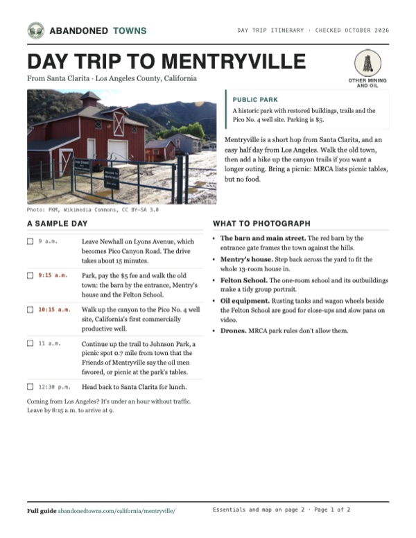
Take it with you
Day trip itinerary
The essentials, the sample day with boxes to tick, what to photograph and the coordinates, on two printable pages. Handy where there's no signal.
Download the PDF (657 KB)Mentryville is a short hop from Santa Clarita, and an easy half day from Los Angeles. Walk the old town, then add a hike up the canyon trails if you want a longer outing. Bring a picnic: MRCA lists picnic tables, but no food.
A sample day
- Leave Newhall on Lyons Avenue, which becomes Pico Canyon Road. The drive takes about 15 minutes.
- Park, pay the $5 fee and walk the old town: the barn by the entrance, Mentry's house and the Felton School.
- Walk up the canyon to the Pico No. 4 well site, California's first commercially productive well.
- Continue up the trail to Johnson Park, a picnic spot 0.7 mile from town that the Friends of Mentryville say the oil men favored, or picnic at the park's tables.
- Head back to Santa Clarita for lunch.
Coming from Los Angeles? It's under an hour without traffic. Leave by 8:15 a.m. to arrive at 9.
What to photograph and film
- The barn and main street. The red barn by the entrance gate frames the town against the hills.
- Mentry's house. Step back across the yard to fit the whole 13-room house in.
- Felton School. The one-room school and its outbuildings make a tidy group portrait.
- Oil equipment. Rusting tanks and wagon wheels beside the Felton School are good for close-ups and slow pans on video.
- Drones. MRCA park rules don't allow them.
Map & directions
Getting there
Mentryville is 15 minutes from Santa Clarita and under an hour from downtown Los Angeles without traffic. Both routes end on Lyons Avenue, which becomes Pico Canyon Road and runs to the parking lot.


Base map: USGS The National Map (public domain). Routes: OSRM on © OpenStreetMap contributors data (ODbL), computed October 2026. Times assume dry roads.
- Take Railroad Avenue to Lyons Avenue.0.2 mi
- Turn right onto Lyons Avenue and follow it west under I-5.2.1 mi
- Continue straight as it becomes Pico Canyon Road, to the park at the end.2.4 mi
- From downtown Los Angeles, take US 101 north to I-5 north.17.8 mi
- Follow I-5 north, keeping to the truck lanes past the CA 14 split, to exit 167.13.2 mi
- Turn left onto Lyons Avenue.0.2 mi
- Continue straight as it becomes Pico Canyon Road, to the park at the end.2.4 mi
Road and safety notes
- Parking is $5, paid at the lot.
- Summers in the canyon are hot. Carry water on the trails.
Photos
Mentryville in photos
Visitor reports
Been to Mentryville?
Been there lately? Tell the next visitor what you found: whether you could get in, the state of the road and what's still standing. Photos are welcome. We read every report before it appears here.
Other mining and oil
More lead, iron, mercury and oil ghost towns
The nearest in California.

 Guide
Eagle Mountain
33.86, -115.49Riverside County, California
Kaiser Steel built this town for its iron mine in 1948, and about 4,000 people lived in it. The mine closed in 1983, and the streets of postwar…
 Guide
Leadfield
36.85, -117.06Inyo County, California
Leadfield’s 1920s boom left sheds and mine remains. The road through Titus Canyon is closed for flood repairs, including to hikers and cyclists.
Nearby
Other sites near Mentryville
Straight-line distance from the townsite to other mapped sites in our California index.
- Llano del Rio45.5 mi E · Los Angeles
- Eldoradoville49.1 mi E · Los Angeles
- Caliente63.0 mi N · Kern
- Lytle Creek64.0 mi E · San Bernardino
- Rio Bravo68.3 mi N · Kern
- Agua Mansa75.0 mi E · San Bernardino
- Claraville75.2 mi N · Kern
- La Placita76.2 mi E · Riverside
Sources
Sources and credits
- Wikipedia, "Mentryville, California", retrieved October 2026: history, the Pico No. 4 strike and capping, Mentry's house and funeral, the 1930s exodus, Lagasse, the Chevron donation, landmark texts, fire and storm, film credits.
- Mountains Recreation and Conservation Authority, "Mentryville", checked October 2026: address, parking fee, buildings, trails, and the dog, restroom and picnic-table listings.
- MRCA, "Park Rules", checked October 2026: sunrise-to-sunset hours, leashed dogs, no drones, filming permits.
- SCVHistory.com, "Friends of Mentryville", checked October 2026: tours suspended after 2003, special tours for nonprofits, the iron-ranger fee box, the trail to Johnson Park.
- Islands, "California's Once-Thriving Boomtown At The Base Of A Stunning Canyon" (August 17, 2025): open daily, self-guided, paid parking, markers, the paved trail to Pico No. 4.
- SCV News, "Still Waiting for Mentryville" (Darryl Manzer, October 2013): the house still off-limits to the public.
- Elevation from a USGS 3D Elevation Program point query. Routes: OSRM on OpenStreetMap data, October 2026. Status checked against the sources above on October 19, 2026.
Photo and map credits
- The barn behind the entrance gate, December 2012: PKM, Wikimedia Commons, CC BY-SA 3.0
- The state landmark plaque, 2012: PKM, Wikimedia Commons, CC BY-SA 3.0
- Mentry's house, 2012: PKM, Wikimedia Commons, CC BY-SA 3.0
- Mentry's restored barn, 2012: PKM, Wikimedia Commons, CC BY-SA 3.0
- Felton School, an outhouse and old equipment, 2012: PKM, Wikimedia Commons, CC BY-SA 3.0
- The wooden oil derrick, 2012: Caterpillar84, Wikimedia Commons, CC BY-SA 4.0
- The capped Pico No. 4 well, California's first commercially productive oil well, 2008: Los Angeles, Wikimedia Commons, CC BY-SA 3.0
- Area base map, topo and aerial imagery: USGS The National Map (public domain).
- Historic maps: USGS Historical Topographic Map Collection (public domain): Santa Susana 1903, 1:62,500; Pico 1929, 1:24,000; Pico 1940, 1:24,000; Newhall 1952, 1:24,000.