 Abandoned

Overview
An iron town on Snail Shell Harbor

Fayette Brown, a manager of the Jackson Iron Company, chose this spot on the Garden Peninsula in the late 1860s for what a charcoal iron works needed. The harbor brought in ore and shipped out iron. The limestone cliffs gave flux for smelting and stone for building, and the forests gave charcoal for the furnaces. Between 1867 and 1891 the town made 229,288 tons of pig iron, most of it bound for steelmakers on the lower Great Lakes, where it became rails.
About 500 people lived in and near Fayette, many of them immigrants from Canada, Britain and Ireland, and northern Europe. The town had a cornet band, a baseball team, a horse racing track, a school, a post office and a company store. In 1891 the company stopped smelting: the charcoal iron market had fallen and the hardwood nearby was used up. All but about 20 residents left.
A summer resort used the town from 1916 to 1946. The Escanaba Paper Company traded it to the state for timberland, and it became a state historic site in 1956 and a state park in 1959. Since then the state has stabilized the buildings and added exhibits and a visitor center. You can walk through buildings that have stood for 150 years.
Timeline
Fayette, 1867 to today

- The Jackson Iron Company starts its blast furnace town on Snail Shell Harbor. Fayette Brown, one of its managers, picked the site.
- The furnaces make 229,288 tons of charcoal pig iron, most of it shipped to steelmakers on the lower Great Lakes. About 500 people live in and near the town.
- The company stops smelting as the charcoal iron market falls and the hardwood nearby runs out. All but about 20 residents leave.
- The town is bought and run as a summer resort until 1946.
- After the Escanaba Paper Company trades the town to the state for timberland, it becomes a Michigan State Historic Site on August 23.
- Fayette becomes a state park.
- The townsite joins the National Register of Historic Places on February 16.
What's left
What you'll see


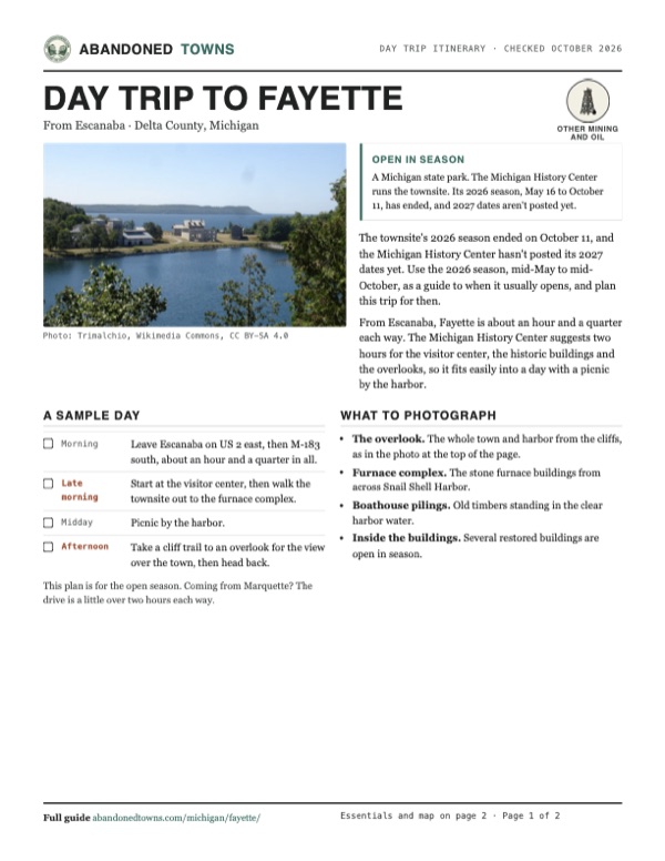
The stone blast furnace complex and the machine shop stand on the shore of Snail Shell Harbor, with the hotel, homes and shops around them. The visitor center has exhibits, and tours are self-guided, with guided tours in the summer months. Old pilings stand in the clear water of the harbor. The park's 5 miles of trails climb the 90-foot limestone cliffs around the harbor to overlooks of the whole town, the view at the top of this page. Northern white cedars on the cliffs are estimated at more than 1,400 years old.
The old USGS sheets below show the same hooked point. The 1932 sheet marks a cluster of buildings on it; the 1958 sheet names Snail Shell Harbor and Middle Bluff and puts the Fayette post office farther south, and by 1985 the townsite is labeled a site inside Fayette State Park, with a campground and boat ramp to the south.
- Blast furnace complex
- Machine shop
- Hotel
- Homes and shops, several open in season
- Boathouse pilings in Snail Shell Harbor
- Cliff-top overlooks


Historic maps
Fayette on USGS maps, 1932–1985
Crops from the USGS Historical Topographic Map Collection, centered on the townsite. Each sheet shows what surveyors mapped that year; compare them with today's topo and aerial on this page.

Day trip
Plan a day trip to Fayette from Escanaba
Take it with you
Day trip itinerary
The essentials, the sample day with boxes to tick, what to photograph and the coordinates, on two printable pages. Handy where there's no signal.
Download the PDF (468 KB)The townsite's 2026 season ended on October 11, and the Michigan History Center hasn't posted its 2027 dates yet. Use the 2026 season, mid-May to mid-October, as a guide to when it usually opens, and plan this trip for then.
From Escanaba, Fayette is about an hour and a quarter each way. The Michigan History Center suggests two hours for the visitor center, the historic buildings and the overlooks, so it fits easily into a day with a picnic by the harbor.
A sample day
- Leave Escanaba on US 2 east, then M-183 south, about an hour and a quarter in all.
- Start at the visitor center, then walk the townsite out to the furnace complex.
- Picnic by the harbor.
- Take a cliff trail to an overlook for the view over the town, then head back.
This plan is for the open season. Coming from Marquette? The drive is a little over two hours each way.
What to photograph and film
- The overlook. The whole town and harbor from the cliffs, as in the photo at the top of the page.
- Furnace complex. The stone furnace buildings from across Snail Shell Harbor.
- Boathouse pilings. Old timbers standing in the clear harbor water.
- Inside the buildings. Several restored buildings are open in season.
Map & directions
Getting there
Escanaba is the nearest city, about an hour and a quarter away: east on US 2, then south on M-183 down the Garden Peninsula to the park. From Marquette, the route takes US 41 south to US 2.


Base map: USGS The National Map (public domain). Routes: OSRM on © OpenStreetMap contributors data (ODbL), computed October 2026. Times assume dry roads.
- From Ludington Street, take Stephenson Avenue north and Washington Avenue through the roundabout to US 2.1.7 mi
- Follow US 2 (signed with US 41 and M-35 at first) east.36 mi
- Turn right onto M-183 and follow it south down the Garden Peninsula.16.5 mi
- Turn right onto the Fayette State Park access road.1.0 mi
- From Washington Street, turn onto Front Street and take US 41 (with M-28 at first) south.51 mi
- Turn left onto US 2.22.7 mi
- Turn right onto M-183 and follow it south.16.5 mi
- Turn right onto the Fayette State Park access road.1.0 mi
Road and safety notes
- M-183 is the road down the Garden Peninsula to the park. An undated listing rates the trip 2WD.
- A Michigan Recreation Passport is required for vehicle entry.
- Some townsite paths are graded, packed crushed rock. The visitor center is accessible, and a wheelchair can be borrowed when one is free.
Photos
Fayette in photos
Visitor reports
Been to Fayette?
Been there lately? Tell the next visitor what you found: whether you could get in, the state of the road and what's still standing. Photos are welcome. We read every report before it appears here.
Other mining and oil
More lead, iron, mercury and oil ghost towns
The nearest, in other states.

 Guide
Stonehaven
43.49, -87.80Ozaukee County, Wisconsin
From 1901 to 1925 a stone company quarried dolomite here and housed its immigrant workers in a company town. The pit is now a 26-acre lake in a state…
 Guide
Taconite Harbor
47.52, -90.93Cook County, Minnesota
A neighborhood of 22 prefab houses that Erie Mining built beside its taconite dock in 1957. The company cleared it in the late 1980s, and the streets…
Nearby
Other sites near Fayette
Straight-line distance from the townsite to other mapped sites in our Michigan index.
- Wilson37.2 mi W · Menominee
- Arthur Bay46.7 mi SW · Menominee
- Gould City53.5 mi NE · Mackinac
- Longrie55.5 mi W · Menominee
- Glen Haven64.5 mi SE · Leelanau
- Northport65.1 mi SE · Leelanau
- Aral72.0 mi SE · Benzie
- Garnet72.2 mi NE · Mackinac
Sources
Sources and credits
- ghosttowns.com, "Fayette": fact sheet fields (roads, climate, best time).
- Wikipedia, "Fayette Historic State Park", retrieved October 2026: production, population and origins, 1891 closure and reasons, resort years, the paper company trade, historic site and park dates, NRHP listing, cedars, coordinates and elevation.
- Michigan History Center, Fayette Historic Townsite, official site, read October 19, 2026 and again October 21, 2026, when it still showed the 2026 schedule and no 2027 dates: Fayette Brown, the site's resources, about 500 people, town life, where the iron went, 1959 acquisition, 2026 season and hours, address, phone, free admission, Recreation Passport, time to allow, accessibility, gift shop.
- Michigan DNR, Fayette Historic State Park, read October 21, 2026: no 2027 townsite dates or upcoming events listed; 5 miles of trails, 90-foot limestone cliffs, buildings standing for 150 years, guided tours in summer, amenities.
- Routes: OSRM on OpenStreetMap data, October 2026.
Photo and map credits
- Panorama of the townsite, 2013: Dkcoats645, Wikimedia Commons, CC BY-SA 3.0
- The townsite from the overlook trail, 2008: Trimalchio, Wikimedia Commons, CC BY-SA 4.0
- Frame buildings and an old wagon, 2009: Susan Schmitt, Wikimedia Commons, CC BY-SA 3.0
- Pilings and limestone cliffs at Snail Shell Harbor, 2016: AaronJoePick, Wikimedia Commons, CC BY-SA 4.0
- Boathouse pilings in Snail Shell Harbor, 2016: AaronJoePick, Wikimedia Commons, CC BY-SA 4.0
- The blast furnace complex: two stone stacks between casting houses, seen across the harbor, July 2026: TCP04, Wikimedia Commons, CC BY 4.0
- The furnace complex through a window of the overseer's house across the bay, 2008: Trimalchio, Wikimedia Commons, CC BY-SA 3.0
- Topo map, area base map and aerial imagery: USGS The National Map (public domain).
- Historic maps: USGS Historical Topographic Map Collection (public domain): Burnt Bluff NW 1932, 1:31,680; Fairport 1958, 1:62,500; Fayette 1985, 1:24,000.