 Abandoned

Overview
Lead, zinc and a saloon that stayed

Goodsprings is named for Joseph Good, a cattleman whose herd grazed by a spring in the southeastern foothills of the Spring Mountains. He found silver here in 1861. Nearby Potosi had been mined for lead by Mormon miners since 1856. The district produced lead, zinc, silver, copper and gold, and the Yellow Pine Mining Company, formed in 1901, combined most of the mines and built a mill.
In 1911 a narrow-gauge line linked the mill to the main railroad at Jean, and the town boomed. About 1,000 people lived here by 1915. George Fayle built the Pioneer Saloon in 1913 and a 20-room hotel in 1916, which he advertised as the finest in the West. The boom faded after the war, the rail line closed in 1930, and by the mid-1930s fewer than 100 people were left.
In January 1942 a TWA airliner hit Potosi Mountain, killing all 22 aboard, including Carole Lombard. Clark Gable waited for news at the Pioneer Saloon, which keeps a memorial to them. The 2020 census counted 162 residents, many of whom work in Las Vegas.
Timeline
From Good's spring to the saloon

- Mormon miners work lead at nearby Potosi, which Legends of America calls the oldest lode mine in Nevada.
- Joseph Good, a cattleman, finds silver near the springs where his herd grazes, and later opens a small store.
- Gold turns up in the district: by 1882 according to Legends of America, in 1893 according to Wikipedia.
- Samuel Yount, who bought Good's store, opens a post office.
- Wikipedia dates the town's founding to this year.
- The Yellow Pine Mining Company forms to combine most of the mines and build a mill.
- A narrow-gauge line from the Yellow Pine mill to the main railroad at Jean is finished.
- George Fayle builds the Pioneer Saloon, and the schoolhouse goes up.
- The population peaks near 1,000. Fayle's 20-room hotel opens with a grand ball on May 13, 1916.
- About 400 people remain.
- The rail line closes in 1930, and its tracks come up in 1934.
- TWA Flight 3 crashes into Potosi Mountain. All 22 aboard die, among them the actress Carole Lombard. Clark Gable waits for news at the Pioneer Saloon.
- The Fayle Hotel burns.
- The video game Fallout: New Vegas recreates the town and its saloon. A fan festival has been held here yearly since 2022.
- The census counts 162 residents.
- Goodsprings Elementary, in the 1913 schoolhouse, holds its last day of classes. Its two pupils move to Sandy Valley Elementary in the fall.
What's left
What you'll see


The Pioneer Saloon is the reason most people come. Legends of America says its cherry-wood bar came from the ghost town of Rhyolite. Next door is the general store. The 1913 schoolhouse, on the National Register of Historic Places, is a short walk away. Several old buildings stand in various states of disrepair; the Fayle Hotel burned in 1966. Many houses are lived in, so look from the street.
The 1910 USGS sheet in the next section shows the town at the start of its boom, with the Yellow Pine, Keystone and other mines in the Spring Mountains to the west and Jean on the railroad to the southeast.
- Pioneer Saloon (1913)
- General store
- Schoolhouse (1913)
- Old commercial ruins
- Lombard–Gable memorial in the saloon


Historic maps
Goodsprings on USGS maps, 1910–1989
Crops from the USGS Historical Topographic Map Collection, centered on the townsite. Each sheet shows what surveyors mapped that year; compare them with today's topo and aerial on this page.

Day trip
Plan a day trip to Goodsprings from Las Vegas
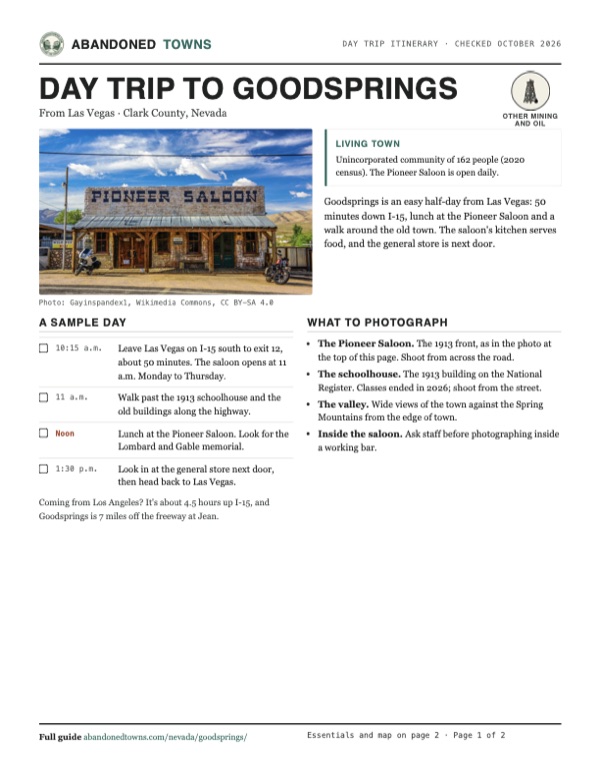
Take it with you
Day trip itinerary
The essentials, the sample day with boxes to tick, what to photograph and the coordinates, on two printable pages. Handy where there's no signal.
Download the PDF (607 KB)Goodsprings is an easy half-day from Las Vegas: 50 minutes down I-15, lunch at the Pioneer Saloon and a walk around the old town. The saloon's kitchen serves food, and the general store is next door.
A sample day
- Leave Las Vegas on I-15 south to exit 12, about 50 minutes. The saloon opens at 11 a.m. Monday to Thursday.
- Walk past the 1913 schoolhouse and the old buildings along the highway.
- Lunch at the Pioneer Saloon. Look for the Lombard and Gable memorial.
- Look in at the general store next door, then head back to Las Vegas.
Coming from Los Angeles? It's about 4.5 hours up I-15, and Goodsprings is 7 miles off the freeway at Jean.
What to photograph and film
- The Pioneer Saloon. The 1913 front, as in the photo at the top of this page. Shoot from across the road.
- The schoolhouse. The 1913 building on the National Register. Classes ended in 2026; shoot from the street.
- The valley. Wide views of the town against the Spring Mountains from the edge of town.
- Inside the saloon. Ask staff before photographing inside a working bar.
Map & directions
Getting there
Goodsprings is 7 miles west of Jean. From Las Vegas, take I-15 south to exit 12 and NV 161, Goodsprings Road. From Los Angeles, take I-15 north to the same exit. Paved all the way.


Base map: USGS The National Map (public domain). Routes: OSRM on © OpenStreetMap contributors data (ODbL), computed October 2026. Times assume dry roads.
- From downtown, take Charleston Boulevard to I-15.2.1 mi
- Take I-15 south.28.4 mi
- Take exit 12 and turn right onto Goodsprings Road, NV 161.6.9 mi
- Continue onto Spring Street into Goodsprings.0.3 mi
- From downtown, take I-10 east, then exit 58A to I-15.42 mi
- Take I-15 north through Barstow toward Las Vegas.196 mi
- Take exit 12 and turn left onto Goodsprings Road, NV 161.7.3 mi
- Continue onto Spring Street into Goodsprings.0.3 mi
Road and safety notes
- Paved all the way from I-15.
- Goodsprings is a living town. Respect private homes and the school grounds.
- Old mines are scattered across the surrounding hills. Stay out of shafts.
Photos
Goodsprings in photos
Visitor reports
Been to Goodsprings?
Been there lately? Tell the next visitor what you found: whether you could get in, the state of the road and what's still standing. Photos are welcome. We read every report before it appears here.
Other mining and oil
More lead, iron, mercury and oil ghost towns
The nearest, in other states.

 Guide
Mineral Park
35.38, -114.15Mohave County, Arizona
Once the Mohave County seat, Mineral Park lost the title to Kingman in 1887 and faded away. Its cemetery and last ruins now sit inside an open-pit…
 Guide
Leadfield
36.85, -117.06Inyo County, California
Leadfield’s 1920s boom left sheds and mine remains. The road through Titus Canyon is closed for flood repairs, including to hikers and cyclists.
Nearby
Other sites near Goodsprings
Straight-line distance from the townsite to other mapped sites in our Nevada index.
Sources
Sources and credits
- ghosttowns.com, "Goodsprings": fact sheet fields (roads, climate, best time, 7 miles west of Jean).
- Wikipedia, "Goodsprings, Nevada", retrieved October 2026: founding, Joseph Good, minerals, schoolhouse and its 2026 closure, Pioneer Saloon, TWA Flight 3, Fallout: New Vegas and the fan festival, 2020 census.
- Legends of America, "Goodsprings": Potosi, Yount's post office, Yellow Pine company, the Jean rail line, population figures, Fayle Hotel, the saloon's bar, Gable at the saloon, current residents.
- Pioneer Saloon, official site, home and "Contact Us" pages, as of October 19, 2026: established 1913, hours, address, phone, age and dog rules, cover charge.
- FOX5 Las Vegas, "Goodsprings Elementary school closes after 113 years" (May 2026): last day of classes, students moving to Sandy Valley.
- Coordinates: Wikipedia (from USGS GNIS). Elevation: USGS 3D Elevation Program point query. Routes: OSRM on OpenStreetMap data, October 2026.
Photo and map credits
- The Pioneer Saloon: Gayinspandex1, Wikimedia Commons, CC BY-SA 4.0
- A windmill and ruins in the old commercial area: Wasteland Wanderer, Wikimedia Commons, CC BY 3.0
- The Pioneer Saloon in 2006: Stan Shebs, Wikimedia Commons, CC BY-SA 3.0
- The saloon's historical marker: MrBill3, Wikimedia Commons, CC BY-SA 3.0
- The 1913 schoolhouse: Ymblanter, Wikimedia Commons, CC BY-SA 3.0
- Goodsprings in its valley: Stan Shebs, Wikimedia Commons, CC BY-SA 3.0
- Goodsprings, with Shenandoah Peak on the horizon: Stan Shebs, Wikimedia Commons, CC BY-SA 3.0
- Topo map, area base map and aerial imagery: USGS The National Map (public domain).
- Historic maps: USGS Historical Topographic Map Collection (public domain): Ivanpah 1910, 1:250,000; Ivanpah 1942, 1:250,000; Kingman 1954, 1:250,000; Goodsprings 1960, 1:62,500; Goodsprings 1989, 1:24,000.