 Abandoned

Overview
Cranberries, blueberries and a company village

Whitesbog sits in the Pine Barrens east of Browns Mills, inside Brendan T. Byrne State Forest. James A. Fenwick began growing cranberries here in 1857 on bog land near the old Hanover Furnace. His son-in-law Joseph J. White took over in 1882 and kept buying land. By 1912 J. J. White Inc. held more than 3,000 acres, the biggest cranberry farm in New Jersey.
The farm built a village to run it: a general store and post office, a school, a pay office, a barrel factory, packing houses and rows of workers' cottages. From 1890 to 1925 about 600 seasonal workers came for the harvest, many of them Italian families from Philadelphia, children included. They lived in camps called Rome and Florence. Lewis Hine photographed the young pickers here in 1910.
White's daughter Elizabeth made the place famous. Working with the USDA botanist Frederick Coville from 1911, she paid local woodsmen for wild bushes with big, sweet berries and bred them. In 1916 Whitesbog sold the first crop of cultivated highbush blueberries. Wikipedia says the farm stayed active into the mid-20th century. The worker camps came down in the 1960s, and the village is now state land. The Whitesbog Preservation Trust now leases the village and keeps it open. Some people still live in the old houses; the creator of a video posted January 2025 calls it "a real community that people live in". The bogs are still harvested each fall.
Video
A fall sunrise hike around the bogs
A hiker sets out from the village at sunrise at the end of October and follows the nature trail and the sand roads on the dikes between the bogs, some full of water and some drained. He passes young Atlantic white cedars, meets a pickup truck on the roads and notices haze and smoke from a fire. He returns through the village past Blueberry Test Field #1, the Darlington house and the old cottages and houses along the sand streets. The creator says he would like to fly a drone here but doesn't; none is used in the video. He reads the history from the state parks website.
 Play “Whitesbog Village - Hiking the Cranberry Bogs of the New Jersey Pinelands” from YouTube
Timeline
From iron country to berry farm

- James A. Fenwick buys bog land along Cranberry Run, south of the old Hanover Furnace, to grow cranberries. The Trust dates the village to this year; Wikipedia says Joseph J. White founded it in the 1870s.
- The Trust says the New Jersey cranberry boom begins. Fenwick's holdings grow to 490 acres.
- Fenwick dies. His son-in-law Joseph J. White takes over the farm, which stays his widowed mother-in-law's until 1911, and buys more land around it.
- About 600 seasonal workers come each year for the harvest. Many are Italian immigrant families from Philadelphia, housed in worker camps called Rome and Florence.
- Elizabeth Coleman White, J. J.'s daughter, begins working on the farm.
- Lewis Hine photographs child cranberry pickers at Whites Bog for the National Child Labor Committee.
- Elizabeth White and USDA botanist Frederick Coville breed wild highbush blueberries collected by local woodsmen. In 1916 Whitesbog sells the first crop of cultivated blueberries.
- J. J. White Inc. controls more than 3,000 acres, the largest cranberry farm in New Jersey.
- A Sears kit house goes up as a laboratory for the Cranberry Substation, studying fruit diseases.
- Elizabeth White builds her house, Suningive, with the farm office and an infirmary for workers on its ground floor.
- The worker camps Rome and Florence are torn down; only foundations remain in the woods.
- The village is state land in Brendan T. Byrne State Forest. The Whitesbog Preservation Trust leases it from the state and restores it. Cranberries are still harvested on the bogs each fall.
What's left
What you'll see


Most of the village still stands along its sand streets. The Trust counts about 3,000 acres of bogs, blueberry fields, reservoirs, sand roads and pine forest. A photo caption from 2012 on Commons says four families lived in each workers' cottage, one to a room, with double privies behind. The general store is open Saturdays from 10 a.m. to 2 p.m., when volunteers also open other buildings. Suningive, Elizabeth White's 1923 house, has been restored and is shown on tours, with a native Pinelands garden beside it. The Cranberry Substation lab is a Sears kit house from about 1918. The foundations of the Rome and Florence worker camps lie in the woods.
Trails lead out along the bogs. The Trust's rules: keep dogs leashed in the village and pick up after them, don't get in the way of farm staff or machines, stay out of the bogs, and expect the paths nearest the bogs to close in the growing and harvest season. From late September into early October you can watch the harvest from viewing spots around the bogs.
On the 1888 USGS sheet below the ground is still open pine land with Cranberry Brook and Hanover Furnace to the north. The 1951 sheet shows Whitesbog as a cluster of buildings by the road, with cranberry bogs to the south and east and a big reservoir to the northeast.
- General store and water tower
- Workers' cottages and boarding house
- Schoolhouse
- Barrel factory and packing buildings
- Suningive, Elizabeth White's house, and its garden
- Blueberry test fields
- Cranberry bogs, dikes and reservoirs
- Foundations of the Rome and Florence worker camps


Historic maps
Whitesbog on USGS maps, 1888–1951
Crops from the USGS Historical Topographic Map Collection, centered on the townsite. Each sheet shows what surveyors mapped that year; compare them with today's topo and aerial on this page.

Day trip
Plan a day trip to Whitesbog from Browns Mills
Take it with you
Day trip itinerary
The essentials, the sample day with boxes to tick, what to photograph and the coordinates, on two printable pages. Handy where there's no signal.
Download the PDF (506 KB)Whitesbog is ten minutes from Browns Mills and makes an easy day on foot. Come on a Saturday to see inside the general store and other buildings, and in late September or early October to watch the cranberry harvest.
A sample day
- Drive CR 530 from Browns Mills, about 10 minutes. Walk the sand roads along the bogs early.
- Visit the general store and the buildings volunteers open.
- Walk the village streets past the cottages, the water tower and the schoolhouse, and see Suningive's garden.
- Follow a trail to the blueberry test fields.
What to photograph and film
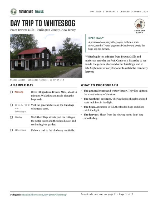
- The general store and water tower. They line up from the street in front of the store.
- The workers' cottages. The weathered shingles and red roofs look best in low light.
- The bogs. At sunrise in fall, the flooded bogs and dikes catch the light.
- The harvest. Shoot from the viewing spots; don't step onto the bog.
Map & directions
Getting there
Browns Mills is the closest town, ten minutes away on Lakehurst Road (CR 530). From Philadelphia the drive crosses into Camden and follows NJ 38 and CR 530 through Pemberton, about an hour. Whitesbog is off CR 530 at mile marker 13.


Base map: USGS The National Map (public domain). Routes: OSRM on © OpenStreetMap contributors data (ODbL), computed October 2026. Times assume dry roads.
- From Browns Mills, follow Trenton Road (CR 545).0.3 mi
- Bear left on Lakehurst Road (CR 530).4.2 mi
- Turn left on Whites Bogs Road into the village.0.4 mi
- From Penn Square, take North Broad Street and Race Street.1.2 mi
- Take the ramp east across the river.1.8 mi
- Follow Admiral Wilson Boulevard (US 30).2.2 mi
- Bear left onto Kaighns Avenue (NJ 38).0.5 mi
- Follow NJ 38 east.18.7 mi
- Continue on CR 530: South Pemberton Road, West Hampton Street and the Pemberton Bypass.4.8 mi
- Turn right on Pemberton–Browns Mills Road (CR 530).3.7 mi
- Turn right on Juliustown Road, which becomes Lakehurst Road (CR 530).4.5 mi
- Turn left on Whites Bogs Road into the village.0.4 mi
Road and safety notes
- The Trust's address is 120 W. Whites Bog Road #34, Browns Mills. The village is off CR 530.
- Roads around the bogs are sand. A video posted January 2025 shows cars and a pickup on them; some dead-end at water, and water levels change through the year.
- Paths closest to the cranberry bogs close during the growing and harvest season. Never drive or walk into a bog.
Photos
Whitesbog in photos
Visitor reports
Been to Whitesbog?
Been there lately? Tell the next visitor what you found: whether you could get in, the state of the road and what's still standing. Photos are welcome. We read every report before it appears here.
Farm and ranch
More farm and ranch ghost towns
The nearest in New Jersey, then the nearest elsewhere.

 Guide
Walpack Center
41.16, -74.88Sussex County, New Jersey
A crossroads village of white clapboard buildings in the Flat Brook valley, bought out for a reservoir that was never filled. The National Park…
 Guide
Doodletown
41.30, -73.99Rockland County, New York
A valley hamlet settled by 1762 and bought out for Bear Mountain State Park. Its foundations, stone steps and two cemeteries lie along old roads that…
Nearby
Other sites near Whitesbog
Straight-line distance from the townsite to other mapped sites in our New Jersey index.
- Ong's Hat6.8 mi SW · Burlington
- Crossley11.3 mi E · Ocean
- Aserdaten11.5 mi SE · Ocean
- Eagle13.6 mi S · Burlington
- High Crossing15.0 mi SW · Burlington
- Double Trouble State Park15.8 mi E · Ocean
- Hampton Furnace15.9 mi SW · Burlington
- Atsion18.9 mi SW · Burlington
Sources
Sources and credits
- ghosttowns.com, "Whitesbog": fact sheet fields (county, road, climate, best time, remains), CR 530 at mile marker 13, residents in the old homes, cranberry farming from about the 1860s.
- Whitesbog Preservation Trust: home page, "Maps & Hours", "FAQ", "Book a Tour" and "History", read October 29, 2026: hours, free entry, the Saturday buildings and monthly tour, dogs, bog rules, harvest season, tour types, address and phone; 1857, Fenwick's 108 and 490 acres, J. J. White, Elizabeth White from 1893, Suningive in 1923, the 3,000 acres, the registers.
- Wikipedia, "Brendan T. Byrne State Forest", retrieved October 2026: the company town founded in the 1870s, the blueberry work of Elizabeth White and Coville, activity through the mid-20th century, the Trust's lease, the HALS survey.
- Signe Owen, "The Beginning of Blueberry Farming: The Story of Whitesbog", New Jersey Agricultural Society, June 25, 2024: Fenwick's 490 acres, the 1911 breeding work, collectors paid for bushes, Italian children around 1900, Suningive's infirmary.
- The History Girl, "The Cranberry Bog Would Serve as Lawn" (June 29, 2012): 3,000 acres by 1912, 600 seasonal workers 1890–1925, the 1916 blueberry, the store, post office, school and pay office, the c. 1918 Sears kit lab, Rome and Florence demolished in the 1960s.
- Wikimedia Commons photographs of September 8, 2012 (Apc106): the store, cottages and bogs as they stood then, and the caption on four families to a cottage.
- WALTER ZOLNA NATURE ADVENTURE DISCOVERY, "Whitesbog Village - Hiking the Cranberry Bogs of the New Jersey Pinelands", YouTube, posted January 2, 2025: the video on this page; the sand roads with traffic, the village still occupied, the test field and the houses.
- Elevation: USGS 3D Elevation Program point query. Routes: OSRM on OpenStreetMap data, October 2026.
Photo and map credits
- Workers' cottages and the water tower, September 2012: Apc106, Wikimedia Commons, CC BY-SA 3.0
- The general store, September 2012: Apc106, Wikimedia Commons, CC BY-SA 3.0
- A workers' house, September 2012: James Welsh, Wikimedia Commons, CC BY-SA 3.0
- Flooded bogs, September 2012: Apc106, Wikimedia Commons, CC BY-SA 3.0
- Harvest on a flooded bog, October 2009: Parellada, Wikimedia Commons, CC BY-SA 3.0
- Cranberry pickers at Whites Bog, September 1910 (Lewis Hine): Lewis Wickes Hine, National Child Labor Committee, Wikimedia Commons, Public domain
- The company store, survey photo after 2000: Historic American Landscapes Survey (Library of Congress), Wikimedia Commons, Public domain
- The boarding house, survey photo after 2000: Historic American Landscapes Survey (Library of Congress), Wikimedia Commons, Public domain
- The schoolhouse, survey photo after 2000: Historic American Landscapes Survey (Library of Congress), Wikimedia Commons, Public domain
- The water tower, survey photo after 2000: Historic American Landscapes Survey (Library of Congress), Wikimedia Commons, Public domain
- The barrel factory from the rear, survey photo after 2000: Historic American Landscapes Survey (Library of Congress), Wikimedia Commons, Public domain
- Porch of Suningive, Elizabeth White's house, survey photo after 2000: Historic American Landscapes Survey (Library of Congress), Wikimedia Commons, Public domain
- A sand road on a dike between the bogs, survey photo after 2000: Historic American Landscapes Survey (Library of Congress), Wikimedia Commons, Public domain
- Area base map, topo and aerial imagery: USGS The National Map (public domain).
- Historic maps: USGS Historical Topographic Map Collection (public domain): Pemberton 1888, 1:62,500; Camp Dix 1918, 1:62,500; Browns Mills 1951, 1:24,000.