 Abandoned
Overview
The Wool Capital of the World

August Scherneckau came to this high plateau in 1874, and from 1879 to 1887 his place had a post office called Cross Hollow. Local Native people pronounced his name something like Shaniko, and that spelling stuck. In May 1900 the Columbia Southern Railway, a Union Pacific subsidiary, finished a branch from Biggs Junction on the Columbia River, and businessmen from The Dalles built a town at the end of the line.
Shaniko became the shipping point for 20,000 square miles of wool, wheat, cattle and sheep country. Its wool warehouse was the largest in the state. In 1903 the town shipped 2,229 tons of wool and more than a million bushels of wheat and earned the name Wool Capital of the World. The 1910 census counted 495 people; Legends of America gives 600.
By 1911 another Union Pacific line, up the Deschutes River canyon to Bend, was taking the traffic, and Shaniko began to fade. Legends of America says a fire later destroyed much of the business district and there was no money to rebuild. Passenger trains stopped in the early 1930s. The town never emptied, though: 30 people lived there in 2020. The Shaniko Historic District, on the National Register, takes in the hotel, the city hall and jailhouse, a schoolhouse and 42 other properties.
Video
Shaniko in 30 seconds
The Wool Capital of the World: the Hotel Shaniko before 1912, the 1900 water tower, old cars around town and 4th Street today.
Timeline
Shaniko through the years

- August Scherneckau settles in the area. The town's name comes from local Native pronunciation of his name.
- A post office called Cross Hollow opens in May, with Scherneckau as postmaster. It closes in 1887.
- The Columbia Southern Railway finishes its branch from Biggs Junction in May, and Shaniko becomes its terminus. The Shaniko post office opens.
- The town applies to incorporate, and the city council first meets on March 16. About 4 million pounds of wool are marketed through its warehouse.
- Shaniko ships 2,229 tons of wool and 1,168,866 bushels of wheat and is called the Wool Capital of the World.
- Annual sales reach five million dollars.
- The census counts 495 people, the town's peak.
- Another Union Pacific line, up the Deschutes River canyon to Bend, draws traffic away, and Shaniko begins to decline.
- Passenger service to Shaniko ends. The whole line is shut down by 1966.
- Shaniko is first called a ghost town, at the Oregon Centennial Exposition in Portland.
- Jean and Dorothy Farrell reopen the hotel, which they bought in 1985.
- A dispute over a water easement leads owner Robert Pamplin Jr. to close the hotel, cafe and RV park.
- The census counts 30 residents.
- The hotel reopens to overnight guests on August 1, leased by South Wasco Fire & Rescue (Bend Magazine).
- The city sells the old City Hall building to a private owner in March.
What's left
What you'll see


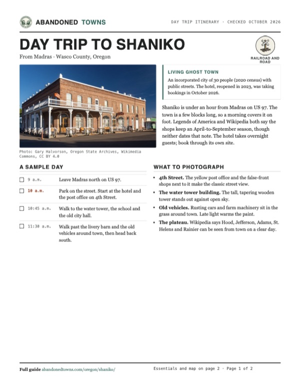
Legends of America describes the brick Shaniko Hotel, first called the Columbia Southern Hotel, as built in 1900 with 18-inch walls of handmade brick. The 10,000-gallon wooden water tower also dates from 1900. The three-room school of 1901 taught students until 1946, was restored in the 1990s and is now a community hall. The two-story city hall held the fire station and jail; the city sold the building to a private owner in March 2026. Legends of America describes the old livery barn as a museum of antique cars, with the Shaniko Sage Museum next door and big sheep sheds on the edge of town. We found no current hours for either museum.
The historic maps below show Shaniko at the bottom edge of both sheets. The 1953 sheet marks an old railroad grade running northeast from town beside US 97. The 1981 sheet shows the small street grid where US 97 meets OR 218, with a pipeline crossing the plateau to the northwest.
- Shaniko (Columbia Southern) Hotel
- Wooden water tower (1900)
- School (1901), now a community hall
- Old city hall with the jail, privately owned since 2026
- Livery barn museum
- Shaniko Sage Museum
- Sheep sheds


Historic maps
Shaniko on USGS maps, 1953–1981
Crops from the USGS Historical Topographic Map Collection, centered on the townsite. Each sheet shows what surveyors mapped that year; compare them with today's topo and aerial on this page.

Day trip
Plan a day trip to Shaniko from Madras
Take it with you
Day trip itinerary
The essentials, the sample day with boxes to tick, what to photograph and the coordinates, on two printable pages. Handy where there's no signal.
Download the PDF (484 KB)Shaniko is under an hour from Madras on US 97. The town is a few blocks long, so a morning covers it on foot. Legends of America and Wikipedia both say the shops keep an April-to-September season, though neither dates that note. The hotel takes overnight guests; book through its own site.
A sample day
- Leave Madras north on US 97.
- Park on the street. Start at the hotel and the post office on 4th Street.
- Walk to the water tower, the school and the old city hall.
- Walk past the livery barn and the old vehicles around town, then head back south.
What to photograph and film
- 4th Street. The yellow post office and the false-front shops next to it make the classic street view.
- The water tower building. The tall, tapering wooden tower stands out against open sky.
- Old vehicles. Rusting cars and farm machinery sit in the grass around town. Late light warms the paint.
- The plateau. Wikipedia says Hood, Jefferson, Adams, St. Helens and Rainier can be seen from town on a clear day.
Map & directions
Getting there
Shaniko sits on US 97 north of Madras, where OR 218 leaves for Antelope and Fossil. From Madras it's a straight run north on US 97. From Bend, the drive follows US 97 through Madras.


Base map: USGS The National Map (public domain). Routes: OSRM on © OpenStreetMap contributors data (ODbL), computed October 2026. Times assume dry roads.
- From 5th Street (US 26 and US 97), turn right onto Northeast 6th Street, US 97.0.6 mi
- Continue north on US 97, The Dalles-California Highway.24.6 mi
- Keep straight on US 97, the Sherman Highway.12.1 mi
- Keep straight onto OR 218, the Shaniko-Fossil Highway, into town.0.1 mi
- From downtown Bend, take Bond Street, Wall Street and Revere Avenue to the Bend Parkway, US 97.1.2 mi
- Follow US 97 north to Madras.41.5 mi
- In Madras, follow 5th Street, Southeast Buff Street and Southeast 7th Street to Northeast 6th Street, US 97.1.2 mi
- Continue north on US 97, then straight onto OR 218 into town.36.8 mi
Road and safety notes
- The whole route is paved highway.
- Snow falls in winter, and the plateau can be very windy.
- Most houses and buildings are private. Stay on the streets and boardwalks.
Photos
Shaniko in photos
Visitor reports
Been to Shaniko?
Been there lately? Tell the next visitor what you found: whether you could get in, the state of the road and what's still standing. Photos are welcome. We read every report before it appears here.
Railroad and road
More railroad, road and fort ghost towns
The nearest, in other states.

 Guide
Wellington
47.75, -121.12King County, Washington
A railroad town on the west side of Stevens Pass where an avalanche swept two snowbound trains into the valley in 1910 and killed 96 people. Nothing…
 Guide
Genoa
39.00, -119.85Douglas County, Nevada
Mormon Station, the 1851 trading post at the foot of the Sierra Nevada, grew into Genoa, Nevada's first town. A 1910 fire took the old station; the…
Nearby
Other sites near Shaniko
Straight-line distance from the townsite to other mapped sites in our Oregon index.
Sources
Sources and credits
- ghosttowns.com, "Shaniko": fact sheet fields (road, climate, best time).
- Wikipedia, "Shaniko, Oregon", retrieved October 2026: Scherneckau and the name, Cross Hollow post office, railroad, incorporation, wool and wheat figures, census counts, 1911 decline, 1959 ghost town label, hotel owners from 1985 to 2023, April-to-September business season, historic district, mountain views.
- Legends of America, "Shaniko, Oregon", read October 2026: founding by The Dalles businessmen, hotel and water tower details, school dates, city hall with fire station and jail, the fire, livery barn and Sage Museum, sheep sheds, 600 population figure, shop season. Its visitor notes still describe the hotel as closed, so they predate 2023 despite the page's March 2026 update stamp.
- Bend Magazine, "Shaniko Reprise", September 1, 2023: hotel reopening on August 1, 2023, the lease to South Wasco Fire & Rescue, lunch and ice cream at the hotel cafe.
- The Historic Shaniko Hotel, official site, read October 19, 2026: online booking and phone number. Its older site, shanikohotel.com, mentions an on-site cafe.
- Madras Pioneer, "Central Oregon History", August 21, 2026: the hotel stood vacant until it reopened in 2023.
- City of Shaniko, official site, read October 19, 2026: sale of the old City Hall announced March 10, 2026, city bathrooms by the community center.
- Coordinates: Wikipedia (from USGS GNIS). Elevation: USGS 3D Elevation Program point query. Routes: OSRM on OpenStreetMap data, October 2026.
Photo and map credits
- The post office and shops on 4th Street, 2004: Gary Halvorson, Oregon State Archives, Wikimedia Commons, CC BY 4.0
- The old water tower building, 2013: Gary Halvorson, Oregon State Archives, Wikimedia Commons, CC BY 4.0
- Stages leaving the Hotel Shaniko, before 1912: B. B. Bakowski, Wikimedia Commons, Public domain
- A train at the depot, by 1911: B. B. Bakowski, Wikimedia Commons, Public domain
- Old cars in Shaniko, 2019: Gary Halvorson, Oregon State Archives, Wikimedia Commons, CC BY 4.0
- A two-lane road across the plateau near Shaniko, 2017: Kingofthedead, Wikimedia Commons, CC BY-SA 4.0
- The Shaniko Hotel, 2019: Gary Halvorson, Oregon State Archives, Wikimedia Commons, CC BY 4.0
- An old truck in front of a barn painted SHANIKO, 2023: Mattsjc, Wikimedia Commons, CC BY 4.0
- A wagon outside the Shaniko Sage Museum, 2023: Mattsjc, Wikimedia Commons, CC BY 4.0
- The old City Hall, 2023: Mattsjc, Wikimedia Commons, CC BY 4.0
- The Shaniko Wagon Yard shelter, with a barn behind, 2023: Mattsjc, Wikimedia Commons, CC BY 4.0
- The post office, 2023: Mattsjc, Wikimedia Commons, CC BY 4.0
- Topo map, area base map and aerial imagery: USGS The National Map (public domain).
- Historic maps: USGS Historical Topographic Map Collection (public domain): The Dalles 1953, 1:250,000; Condon 1981, 1:100,000.