 Abandoned

Overview
The town under Windy Mountain

Wellington was a railroad town. The Great Northern built it in 1893 on the west side of Stevens Pass, and from 1900 it sat at the west portal of the railroad's first Cascade Tunnel, 2.6 miles long.
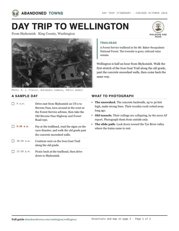
In late February 1910 a nine-day blizzard trapped a passenger train and a mail train at Wellington. Early on March 1, in a thunderstorm, a slab avalanche broke loose on Windy Mountain and carried both trains about 150 feet down into the Tye River valley. Ninety-six people died: 35 passengers, 58 railroad men on the trains and three at the depot. Twenty-three survived. It remains the deadliest avalanche in US history.
That October the railroad renamed the town Tye and began building concrete snowsheds. When the longer second Cascade Tunnel opened in 1929, the line moved off the mountainside and the town was abandoned. Today Wellington is the eastern trailhead of the Iron Goat Trail, with interpretive signs about the disaster.
Timeline
The railroad, the slide and the new tunnel

- The Great Northern Railway builds over Stevens Pass. Wellington grows up as a railroad camp on the west side of the crest.
- A 2.6-mile tunnel under the pass opens, its west portal at Wellington.
- A nine-day blizzard strands a Great Northern passenger train and a mail train, both bound from Spokane to Seattle, at Wellington. On the worst day 11 feet of snow falls.
- About 1 a.m., during a thunderstorm, a slab avalanche off Windy Mountain sweeps both trains about 150 feet down into the Tye River valley. 96 people die and 23 survive.
- The last bodies are recovered, about 21 weeks after the slide.
- The railroad renames the town Tye and starts building concrete snowsheds over the tracks.
- The 7.8-mile second Cascade Tunnel opens lower down. The depot closes, the town is abandoned and later burns.
- The Iron Goat Trail is built on the old grade, with Wellington as its eastern trailhead.
What's left
What you'll see

None of the town's buildings remain. What's left is railroad concrete. An Associated Press report from 2010 describes the snowshed remnants as long concrete backwalls up to 30 feet high, their wooden roofs rotted away, and several ruined tunnels along the trail whose ceilings are collapsing. Stay out of them. The Forest Service lists interpretive signs on the Wellington train disaster along the trail.
The oldest USGS sheet below carries a 1902 date, but it labels the site Tye and draws the long Cascade Tunnel from Scenic under Stevens Pass, so it is a later printing with the 1929 line added. The 1975 sheet marks the Old Cascade Tunnel and the old railroad grade above US 2, with Windy Mountain to the west.
- Concrete snowshed walls
- Ruined tunnels (stay out)
- Railroad grade
- Interpretive signs


Historic maps
Wellington on USGS maps, 1902–1975
Crops from the USGS Historical Topographic Map Collection, centered on the townsite. Each sheet shows what surveyors mapped that year; compare them with today's topo and aerial on this page.

Day trip
Plan a day trip to Wellington from Skykomish
Take it with you
Day trip itinerary
The essentials, the sample day with boxes to tick, what to photograph and the coordinates, on two printable pages. Handy where there's no signal.
Download the PDF (598 KB)Wellington is half an hour from Skykomish. Walk the first stretch of the Iron Goat Trail along the old grade, past the concrete snowshed walls, then come back the same way.
A sample day
- Drive east from Skykomish on US 2 to Stevens Pass, turn around at the crest as the Forest Service advises, then take the Old Stevens Pass Highway and Forest Road 050.
- Pay at the trailhead, read the signs on the 1910 disaster, and walk the old grade past the concrete snowshed walls.
- Continue west on the Iron Goat Trail along the old grade.
- Picnic back at the trailhead, then drive down to Skykomish.
What to photograph and film
- The snowshed. The concrete backwalls, up to 30 feet high, make strong lines. Their wooden roofs rotted away long ago.
- Old tunnels. Their ceilings are collapsing, by the 2010 AP report. Photograph them from outside only.
- The slide path. Look down toward the Tye River valley where the trains came to rest.
Map & directions
Getting there
Wellington is off US 2 just west of Stevens Pass. Skykomish is the nearest town; from Seattle the drive runs out through Monroe and up the Skykomish valley. The Forest Service turnoff is at milepost 64.4, just west of the pass, onto the Old Stevens Pass Highway. Our routes make the same turn onto the road map data calls Tye Road, and stop at the townsite point 1.9 miles in. For the trailhead lot, the Forest Service says to drive 2.8 miles from US 2 and turn right on Forest Road 050.


Base map: USGS The National Map (public domain). Routes: OSRM on © OpenStreetMap contributors data (ODbL), computed October 2026. Times assume dry roads.
- From Railroad Avenue in Skykomish, take 5th Street North up to US 2.0.2 mi
- Turn right on US 2 (Stevens Pass Highway) and follow it east.15.7 mi
- Just west of the pass, turn left on Tye Road, the Old Stevens Pass Highway. The Forest Service advises eastbound drivers to turn around at the pass and come back instead. The route ends at the townsite point; the trailhead is 2.8 miles from US 2, right on Forest Road 050.1.9 mi
- From downtown Seattle, take I-5 north, exit 168B onto SR 520, then follow I-405 north.17.5 mi
- Take exit 23 to SR 522 east toward Monroe.14.8 mi
- Follow US 2 east up the Skykomish valley.49.8 mi
- Just west of the pass, turn left on Tye Road, the Old Stevens Pass Highway, or turn around at the pass first as the Forest Service advises. The route ends at the townsite point; for the trailhead, turn right on Forest Road 050 2.8 miles from US 2.1.9 mi
Road and safety notes
- The Forest Service gives the turnoff as milepost 64.4 on US 2. Sight distance there is poor, so if you're eastbound it advises driving on to Stevens Pass, turning around at the crest and coming back.
- From US 2 it is 2.8 miles on the Old Stevens Pass Highway to Forest Road 050, then right to the trailhead lot.
- The Associated Press reported in 2010 that the trail is usually snow-free from mid-May through late October and should be avoided in winter for avalanche danger. Check the Northwest Avalanche Center before going.
- The Iron Goat Trail is closed to motor vehicles, bicycles and stock.
Photos
Wellington in photos
Visitor reports
Been to Wellington?
Been there lately? Tell the next visitor what you found: whether you could get in, the state of the road and what's still standing. Photos are welcome. We read every report before it appears here.
Railroad and road
More railroad, road and fort ghost towns
The nearest, in other states.

 Guide
Shaniko
45.00, -120.75Wasco County, Oregon
For a decade Shaniko was the railhead for 20,000 square miles of wool, wheat and cattle country. The trade moved to another line after 1911, and a…
 Guide
Genoa
39.00, -119.85Douglas County, Nevada
Mormon Station, the 1851 trading post at the foot of the Sierra Nevada, grew into Genoa, Nevada's first town. A 1910 fire took the old station; the…
Nearby
Other sites near Wellington
Straight-line distance from the townsite to other mapped sites in our Washington index.
- Galena18.0 mi NW · Snohomish
- Mineral City20.2 mi NW · Snohomish
- Monte Cristo20.7 mi NW · Snohomish
- Rockdale29.2 mi SW · King
- Blewett31.1 mi SE · Chelan
- Sultan33.0 mi W · Snohomish
- Roslyn34.8 mi S · Kittitas
- Kerriston40.0 mi SW · King
Sources
Sources and credits
- USDA Forest Service, "Iron Goat Trail 1074 Wellington", checked October 2026: route on the Great Northern grade, interpretive signs, pass required, closed to motor vehicles, bikes and stock, directions.
- USDA Forest Service, "Wellington Trailhead", page updated July 2026: open status, sunrise-to-sunset day use, fees and passes, vault toilets, no water, turnaround advice, FR 050, trailhead elevation.
- Wikipedia, "Wellington, Washington", retrieved October 2026: founding, the blizzard and avalanche, deaths and survivors, renaming to Tye, snowsheds, 1929 abandonment.
- KATU / Associated Press, "Washington rail trail evokes deadly 1910 avalanche" (February 2010): 1900 and 1929 tunnels, snowshed backwalls, ruined tunnels with collapsing ceilings, trail construction years, snow-free season, winter avalanche danger.
- Elevation: USGS 3D Elevation Program point query. Routes: OSRM on OpenStreetMap data, October 2026.
Photo and map credits
- Tracks and buildings at Wellington, about 1910: Webster & Stevens, Wikimedia Commons, Public domain
- Workmen at the wreck of a runaway train near Wellington, about 1909: Webster & Stevens, Wikimedia Commons, Public domain
- Snowshed plan, Scenic to Tye, Railway Age Gazette, 1914: Unknown author, Wikimedia Commons, Public domain
- Wreckage of a train swept off the tracks by the avalanche, March 1910: E. J. Frazier, Wikimedia Commons, Public domain
- Wellington under deep snow, 1910, by Asahel Curtis: Asahel Curtis, Wikimedia Commons, Public domain
- Bailets Hotel buried in snow, 1910, by Asahel Curtis: Asahel Curtis, Wikimedia Commons, Public domain
- Topo map, area base map and aerial imagery: USGS The National Map (public domain).
- Historic maps: USGS Historical Topographic Map Collection (public domain): Skykomish 1902, 1:125,000; Wenatchee 1957, 1:250,000; Skykomish River 1975, 1:100,000.