 Abandoned

Overview
Gold, then apples

Julian sits in the Cuyamaca Mountains, about an hour and a half by road northeast of downtown San Diego. In 1869 Drury Bailey passed through with his cousins Mike and Webb Julian on the way from San Bernardino to Arizona. Bailey stayed, and named the settlement for Mike Julian. That same year Fred Coleman, a formerly enslaved man, spotted gold in the bed of a creek just west of town, the creek that now bears his name.
The first hard-rock claim, the Washington mine, was filed on February 22, 1870, and Julian became a tent city almost overnight. A sawmill followed that April. Rival camps at Coleman City, Branson City and Eastwood failed, and in 1873 the courts ruled the mines were not part of the Cuyamaca rancho. Julian's early Black community was large for the county: in 1880, 33 of San Diego County's 55 Black residents lived around Julian.
When the gold rush faded, Julian stayed. James Madison had brought a wagonload of young apple trees into the mountains, and apples became the town's trade. Julian Apple Days has run since 1949, and since 1976 buildings on Main Street must look no newer than 1913. The 2020 census counted 1,768 people.
Timeline
From Coleman Creek to Apple Days

- Drury Bailey, traveling from San Bernardino toward Arizona with his cousins Mike and Webb Julian, stays in the Cuyamaca Mountains and names the settlement for Mike Julian.
- A. E. "Fred" Coleman, a formerly enslaved man, spots gold in the bed of what is now Coleman Creek, just west of Julian.
- The first lode claim is filed and named the Washington mine, for George Washington's birthday. Julian becomes a tent city almost overnight.
- The area's first sawmill is built. Rival camps at Coleman City, Branson City and Eastwood fail.
- The courts rule that the Cuyamaca rancho grant does not include Julian or its mines.
- Of the 55 Black people counted in San Diego County, 33 live in the Julian area.
- The first Julian Apple Days festival.
- A plan requires building exteriors on Main Street to look "no younger in age than 1913."
- The census counts 1,768 people.
- Julian becomes an International Dark Sky Community, the second in California.
What's here
A historic district


Julian is California Historical Landmark No. 412, and the county zoning code defines the townsite as the Julian Historic District. An architectural review board appointed by the county supervisors oversees changes there. The Hoskins House is one of the district's Victorian buildings.
The Julian Pioneer Museum, at 2811 Washington Street, is in a late-1800s building in a county park. The county lists nineteenth-century clothing and household furnishings, gold-mining and American Indian artifacts, Victorian pianos, an original Julian City buggy and sleigh, and one of the finest lace collections in California. The park has restrooms, drinking fountains and room for a picnic.
The historic maps below show the mining country around the town. The 1903 sheet puts Julian on the road between Wynola Valley and Banner, with Coleman Creek to the west. The 1960 sheet, centered south-east of downtown, marks the Helvetia Mine, the San Diego Mine Group and the Bluehill Mine on the hills just east of town.
- Main Street historic district
- Julian Pioneer Museum
- Hoskins House


Historic maps
Julian on USGS maps, 1903–1960
Crops from the USGS Historical Topographic Map Collection, centered on the townsite. Each sheet shows what surveyors mapped that year; compare them with today's topo and aerial on this page.

Day trip
Plan a day trip to Julian from Ramona
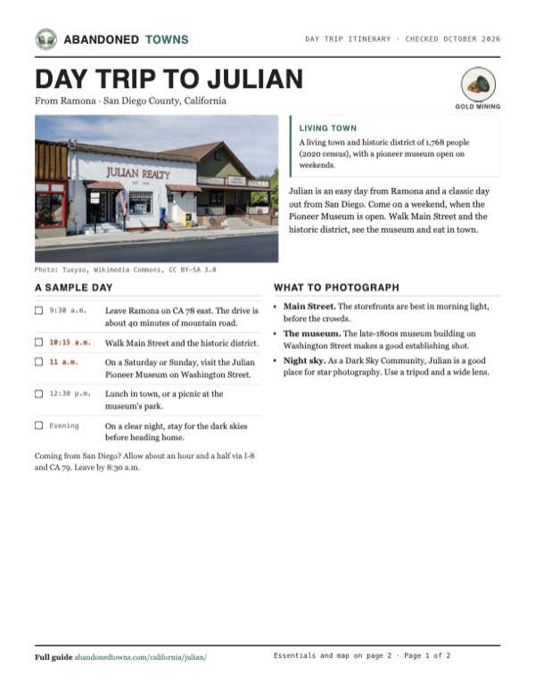
Take it with you
Day trip itinerary
The essentials, the sample day with boxes to tick, what to photograph and the coordinates, on two printable pages. Handy where there's no signal.
Download the PDF (572 KB)Julian is an easy day from Ramona and a classic day out from San Diego. Come on a weekend, when the Pioneer Museum is open. Walk Main Street and the historic district, see the museum and eat in town.
A sample day
- Leave Ramona on CA 78 east. The drive is about 40 minutes of mountain road.
- Walk Main Street and the historic district.
- On a Saturday or Sunday, visit the Julian Pioneer Museum on Washington Street.
- Lunch in town, or a picnic at the museum's park.
- On a clear night, stay for the dark skies before heading home.
Coming from San Diego? Allow about an hour and a half via I-8 and CA 79. Leave by 8:30 a.m.
What to photograph and film
- Main Street. The storefronts are best in morning light, before the crowds.
- The museum. The late-1800s museum building on Washington Street makes a good establishing shot.
- Night sky. As a Dark Sky Community, Julian is a good place for star photography. Use a tripod and a wide lens.
Map & directions
Getting there
Ramona is about 40 minutes west on CA 78. From San Diego, the fastest way runs out I-8 and up CA 79 through Cuyamaca. Both are paved all the way. The routes end at Wikipedia's map point for Julian, about a mile south-east of downtown; park on or near Main Street.


Base map: USGS The National Map (public domain). Routes: OSRM on © OpenStreetMap contributors data (ODbL), computed October 2026. Times assume dry roads.
- Head east on Main Street (CA 78), which becomes Julian Road.15.4 mi
- Continue on CA 78/79, the Julian Highway, then Julian Road.6.6 mi
- Follow Washington Street and turn right on Main Street into downtown Julian.0.4 mi
- The route continues on Porter Lane, CA 79 and Oak Heights Road to Wikipedia's map point south-east of town.1.2 mi
- From downtown San Diego, take CA 94 east, then exit 9B onto CA 125 north and exit 18B onto I-8.12.1 mi
- Follow I-8 east to exit 40.25.0 mi
- Turn left onto Japatul Valley Road, which becomes CA 79, and follow it north through Cuyamaca.22.4 mi
- Turn right on Oak Heights Road. Downtown Julian is about a mile farther north on CA 79.0.3 mi
Road and safety notes
- Paved all the way. CA 78 and CA 79 are winding mountain roads.
- Julian is a living town. Park in town and respect private homes and yards.
Photos
Julian in photos
Visitor reports
Been to Julian?
Been there lately? Tell the next visitor what you found: whether you could get in, the state of the road and what's still standing. Photos are welcome. We read every report before it appears here.
Gold mining
More gold mining ghost towns
The nearest in California.

 Guide
Belleville
34.30, -116.88San Bernardino County, California
In 1860 gold in Holcomb Valley drew nearly 1,500 people to Belleville, high in the San Bernardino Mountains. It nearly became the county seat. A…
 Guide
Randsburg
35.37, -117.66Kern County, California
Gold at the Yellow Aster in 1895 drew more than 1,500 people to Randsburg within two years. The mine worked off and on until 2006. Forty-five people…
Nearby
Other sites near Julian
Straight-line distance from the townsite to other mapped sites in our California index.
- Eastwood1.9 mi NW · San Diego
- Branson City1.9 mi W · San Diego
- Banner2.3 mi E · San Diego
- Coleman City3.6 mi W · San Diego
- Cuyamaca6.0 mi S · San Diego
- Linda Rosa46.5 mi NW · Riverside
- Leon49.8 mi NW · Riverside
- Bombay Beach53.1 mi E · Imperial
Sources
Sources and credits
- ghosttowns.com, "Julian": fact sheet fields (roads, climate, best time, remains).
- Wikipedia, "Julian, California", retrieved October 2026: the founding, Coleman's find, the Washington mine, the sawmill and rival camps, the 1873 ruling, apple trees, the 1880 count, the historic district and landmark No. 412, the review board, the Hoskins House, Apple Days, the 1976 rule, dark-sky status, the 2020 census, elevation, the map point this page uses.
- Julian Pioneer Museum, read October 2026: hours, donation, group visits, address, phone.
- San Diego County Parks, "Julian Museum and Pioneer County Park", read October 2026: county hours, building age, exhibits, restrooms, drinking fountains, picnic area.
- Elevation from a USGS 3D Elevation Program point query. Routes: OSRM on OpenStreetMap data, October 2026. Status checked against the sources above on October 19, 2026.
Photo and map credits
- Julian Realty and the Town Hall on Main Street, 2013: Tuxyso, Wikimedia Commons, CC BY-SA 3.0
- The old schoolhouse: donald gomez, Wikimedia Commons, CC BY-SA 3.0
- Main Street from above, April 2005: Microsomen, Wikimedia Commons, CC BY 2.0
- The Julian Pioneer Museum, 2021: Seauton, Wikimedia Commons, CC BY-SA 4.0
- The Julian Hotel, 2008: Allan Ferguson, Wikimedia Commons, CC BY 2.0
- Downtown after a March snowfall, 2012: Pwmcbride, Wikimedia Commons, CC BY-SA 3.0
- Downtown Julian, December 2004: TimShell, Wikimedia Commons, CC BY-SA 3.0
- Area base map, topo and aerial imagery: USGS The National Map (public domain).
- Historic maps: USGS Historical Topographic Map Collection (public domain): Ramona 1903, 1:125,000; Santa Ysabel 1943, 1:62,500; Julian 1960, 1:24,000.