 Abandoned

Overview
Railroad town, highway town

Afton grew up on the railroad. The Atlantic and Pacific laid track through this part of the Cherokee Nation in 1871, a post office opened in 1886, and a second line arrived in 1901. As a Frisco division point and shipping center for wheat, corn, hay and cattle, the town reached 1,518 people in 1920.
Route 66 came through in 1926, at first on the Ribbon Road, a nine-foot-wide highway from Miami paved in 1922. Filling stations, motor courts and cafés lined First Street, and the Buffalo Ranch trading post opened east of town in 1953. Grand Lake O' the Cherokees, created in 1940, brought more visitors. Then in 1957 the Will Rogers Turnpike bypassed the town. The motels closed one by one, the Buffalo Ranch shut in 1997, and the Palmer Hotel and several downtown buildings burned around 2020.
Afton is a living town, with 734 people in 2020, a school and a city hall. It is on ghost-town lists for what the highway left behind: Afton Station, a restored 1930s filling station that has been closed since 2019, the Rest Haven Motel's sign, the ruins of the Avon Court, and a downtown where, as Legends of America puts it, most of the businesses are gone.
Timeline
Two railroads and a highway


- The Atlantic and Pacific Railroad, later the Frisco, builds through this part of the Cherokee Nation to Vinita.
- A post office opens. A Scottish railroad surveyor is said to have named the town for his daughter, Afton; others point to Robert Burns's poem "Flow Gently, Sweet Afton."
- A second railroad, the Kansas City, Fort Scott and Memphis, comes through. Afton becomes a Frisco division point.
- 1,279 people, two schools, two hotels, two banks, a brick plant, a creamery, mills and grain elevators.
- Peak census count: 1,518.
- US 66 is routed through town. From Miami it follows the Ribbon Road, a nine-foot-wide highway paved in 1922.
- A Mission-style filling station opens on First Street. TheRoute-66.com dates it to 1933 as a Cities Service station; Wikipedia gives 1937 as a D-X.
- A new alignment replaces the Ribbon Road between Miami and Afton.
- Russell and Aleene Kay open the Buffalo Ranch trading post east of town.
- The Will Rogers Turnpike, now I-44, bypasses Afton.
- The Buffalo Ranch closes after Aleene Kay's death, and its buildings are torn down.
- David and Laurel Kane reopen the filling station as Afton Station, a Route 66 welcome stop with David's Packard collection.
- Laurel Kane dies in 2016 and David in 2018. The station closes and is auctioned in June 2019.
- The 1911 Palmer Hotel burns. Wikipedia gives 2019; Legends of America gives July 1, 2020.
- The census counts 734 people (732 in the state encyclopedia).
Afton Station
A filling station and a Packard museum

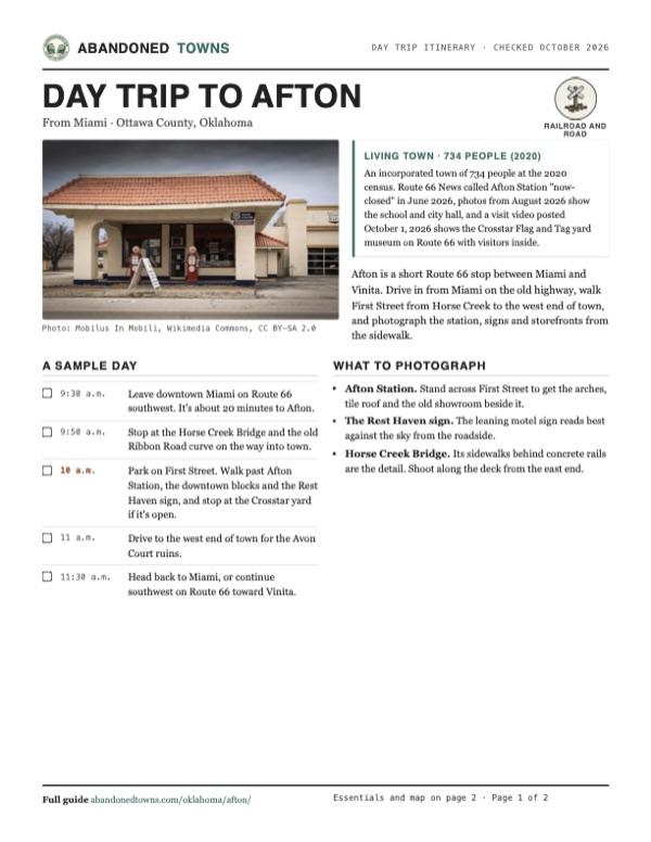
The filling station on First Street is a small Mission Revival building with rough stucco walls and a tile roof. TheRoute-66.com says it opened in 1933 as a Cities Service station, with restrooms on both sides of the office at a time when many stations had none; Wikipedia and Legends of America call it a 1937 D-X station. When John Margolies photographed it in 1982 it was a liquor store, though TheRoute-66.com says it still sold D-X gas in the 1980s before it closed.
David and Laurel Kane, from Connecticut, bought it in 1998 and restored it. Laurel ran it as a Route 66 welcome station for about 15 years, and David kept his Packard collection in the buildings behind. Laurel died in January 2016 and David in August 2018. Most of the Packards were sold, and the station was auctioned in June 2019 for $72,000. It was listed for sale again in 2020 and in January 2023, when the county assessor confirmed the same owners. Route 66 News described it as "now-closed" in June 2026. See it from the street.
What's here
Along First Street


Coming in from the east, Route 66 crosses Horse Creek on a three-span bridge built in 1936 with sidewalks behind concrete rails; it was listed on the National Register in 1995. About 0.7 mile east of the bridge, the narrow 1926–1937 roadbed crosses the highway and curves away. In town, TheRoute-66.com lists the Rest Haven Motel's neon sign, the site of the 1911 Palmer Hotel, Bassett's Food Store (closed in 2009 after half a century), the foundations of the Rogers Motel and several old filling stations. One of them, the Gray Garage at Maple Street, from about 1930, has a rock-faced front with stone battlements along the roof; a visit video posted in February 2026 shows it as a roofless shell. West of town are the ruins and neon sign of the Avon Court, opened in 1936. Nothing is left of the Acme Courts across the road.
One new stop has opened. The Crosstar Flag and Tag display, on the south side of Route 66 downtown, is a yard full of license plates, flags, signs, cars and folk art that its owner opened to travelers. Visitors in February and September 2026 said entry was free, with donations taken. We found no hours posted by the owner.
The Buffalo Ranch site east of town is now a travel center with a convenience store, Legends of America says. People live in Afton and own these buildings: look from the street.
- Afton Station (closed)
- Rest Haven Motel sign
- Palmer Hotel site
- Avon Court ruins and sign
- 1930s filling stations, one a roofless shell
- Crosstar Flag and Tag yard display (visitors welcomed in 2026)
- Horse Creek Bridge (1936)
- 1926–1937 Ribbon Road roadbed east of town
The historic maps below run from the railroad era to the turnpike. The 1907 sheet shows Afton's grid where two railroads meet, before any highway. The 1954 sheet shows US 60, 66 and 69 through town, and the 1963 sheet adds the four-lane turnpike to the north. The 1971 and 1986 sheets show the town grid with First Street, Horse Creek and the I-44 interchange.


Historic maps
Afton on USGS maps, 1907–1986
Crops from the USGS Historical Topographic Map Collection, centered on the townsite. Each sheet shows what surveyors mapped that year; compare them with today's topo and aerial on this page.

Day trip
Plan a day trip to Afton from Miami
Take it with you
Day trip itinerary
The essentials, the sample day with boxes to tick, what to photograph and the coordinates, on two printable pages. Handy where there's no signal.
Download the PDF (431 KB)Afton is a short Route 66 stop between Miami and Vinita. Drive in from Miami on the old highway, walk First Street from Horse Creek to the west end of town, and photograph the station, signs and storefronts from the sidewalk.
A sample day
- Leave downtown Miami on Route 66 southwest. It's about 20 minutes to Afton.
- Stop at the Horse Creek Bridge and the old Ribbon Road curve on the way into town.
- Park on First Street. Walk past Afton Station, the downtown blocks and the Rest Haven sign, and stop at the Crosstar yard if it's open.
- Drive to the west end of town for the Avon Court ruins.
- Head back to Miami, or continue southwest on Route 66 toward Vinita.
What to photograph and film
- Afton Station. Stand across First Street to get the arches, tile roof and the old showroom beside it.
- The Rest Haven sign. The leaning motel sign reads best against the sky from the roadside.
- Horse Creek Bridge. Its sidewalks behind concrete rails are the detail. Shoot along the deck from the east end.
Map & directions
Getting there
Afton is on Route 66, signed as US 60 and US 69, between Miami and Vinita. From Miami it's about 20 minutes southwest on the old highway. From Tulsa it's about an hour and 25 minutes on I-44, leaving at exit 302.

Base map: USGS The National Map (public domain). Routes: OSRM on © OpenStreetMap contributors data (ODbL), computed October 2026. Times assume dry roads.
- From downtown Miami, head south on South Main Street.0.3 mi
- Turn right onto West Steve Owens Boulevard, Route 66 (OK 10 and US 69).1.8 mi
- Continue southwest on Route 66 (US 59 and US 69).10.1 mi
- Continue on Route 66 (US 60 and US 69) into Afton, where it becomes Southeast 1st Street.2.6 mi
- From downtown Tulsa, take Boulder Avenue and West 2nd Street to I-244.1.0 mi
- Follow I-244 and US 412 east.9.1 mi
- Continue on I-44.4.2 mi
- Keep right on I-44 northeast.61.0 mi
- Take exit 302 and follow the ramps.0.8 mi
- Continue on US 59, US 60 and US 69, which is Route 66.1.6 mi
- Continue on Route 66 (US 60 and US 69) into Afton, where it becomes Southeast 1st Street.0.7 mi
Road and safety notes
- Both routes are U.S. highways to the end. Route 66 here is signed as US 60 and US 69, and as US 59 for part of the way.
- People live in Afton, and the closed buildings are private. Look from the street and don't go inside.
Photos
Afton in photos
Visitor reports
Been to Afton?
Been there lately? Tell the next visitor what you found: whether you could get in, the state of the road and what's still standing. Photos are welcome. We read every report before it appears here.
Railroad and road
More railroad, road and fort ghost towns
The nearest in Oklahoma.

 Guide
Depew
35.80, -96.51Creek County, Oklahoma
A railroad and oil town that Route 66 passed through for less than two years. The highway moved north in 1928, and Depew's Main Street is now a row…
 Guide
Boggy Depot
34.32, -96.31Atoka County, Oklahoma
A Choctaw and Chickasaw town on the Texas Road, a Butterfield stage stop and a Confederate supply depot. The railroad missed it in 1872. Its…
Nearby
Other sites near Afton
Straight-line distance from the townsite to other mapped sites in our Oklahoma index.
Sources
Sources and credits
- Larry O'Dell, "Afton," Encyclopedia of Oklahoma History and Culture (updated February 23, 2024): location on US 60/69, railroads, the name, the 1886 post office, populations 1900–2020, the 1911 businesses, Grand Lake, the National Register listings, the hot rod museum.
- Wikipedia, "Afton, Oklahoma", retrieved October 2026: the 1957 bypass, the former motels and cafés, the 1937 D-X date, the closed museum, the Palmer Hotel fire in 2019, the 2020 census, businesses in town, coordinates (GNIS).
- Kathy Alexander, "Afton, Oklahoma – Fading Into History," Legends of America (updated November 2025): the Buffalo Ranch and its closing in 1997, the travel center on the site, the Palmer Hotel fire on July 1, 2020, the station as a liquor store in 1982, the Rest Haven and Avon motels.
- TheRoute-66.com, "Afton" (read October 2026): the Ribbon Road and the 1937 realignment, the Buffalo Ranch dates, Horse Creek Bridge, the Rest Haven, Palmer Hotel, Bassett's, Rogers Motel, Gray Garage, Acme Courts and Avon Court, the station's 1933 Cities Service start.
- Route 66 News, "Majority of Packard collection at Afton Station sold, hauled away", December 20, 2018: the collection sold and the station closed.
- Route 66 News, "Afton Station is for sale for the second time in less than four years", January 20, 2023: the Kanes' purchase in 1998, their deaths, the June 2019 auction for $72,000, the 2020 and 2023 listings, the owners per the county assessor.
- Route 66 News, "Students mostly finish repairing Bob Waldmire's Route 66-themed U-Haul truck", June 23, 2026: "the now-closed Afton Station."
- Route 66 News, "Compromise leaves 1 mile of endangered Ribbon Road in Oklahoma untouched", July 19, 2024, and "Preservation Oklahoma includes original pavement of Route 66 on its Most Endangered Places list", June 14, 2026: the Ribbon Road's 1922 paving, nine-foot width and current condition.
- Travel with a Wiseguy, "Afton, Oklahoma ||| population 734 ||| Route 66 ||| small town, USA", YouTube, posted February 19, 2026: downtown, Afton Station, the Gray Garage and Avon Motel as roofless ruins, the Crosstar yard and its free entry. Not embedded: the creator walks into the Avon Motel and Gray Garage ruins, which are private.
- Orchidsjoy adventures, "Crosstar Flag and Tag Museum Afton Oklahoma", YouTube, posted September 3, 2026: the yard open to visitors, free entry with donations.
- Traveling 4 Autism, "1st stop on our 13 day road trip. Crosstar Afton, OK", YouTube, posted October 1, 2026: visitors inside the Crosstar yard.
- ghosttowns.com, "Afton": fact-sheet cross-check (county, 2WD road, climate, best time, remains).
- Commons file pages for each photo: dates and places taken (the Library of Congress for the 1982 John Margolies slides). Elevation: USGS 3D Elevation Program point query. Routes: OSRM on OpenStreetMap data, October 2026.
Photo and map credits
- Afton Station from Route 66, January 2016: Mobilus In Mobili, Wikimedia Commons, CC BY-SA 2.0
- Afton Station and the Packard showroom, September 2008: TheWhitePelican, Wikimedia Commons, CC BY 3.0
- The station as a liquor store, 1982: The Library of Congress, Wikimedia Commons, No known copyright restrictions
- The downtown colonnade on Route 66, September 2008: TheWhitePelican, Wikimedia Commons, CC BY 3.0
- The Rest Haven Motel sign, January 2016: Mobilus In Mobili, Wikimedia Commons, CC BY-SA 2.0
- A rock-faced gas station building, 1982: The Library of Congress, Wikimedia Commons, No known copyright restrictions
- Horse Creek Bridge on Route 66, August 2010: AbeEzekowitz, Wikimedia Commons, CC BY-SA 3.0
- The Rogers Motel, undated postcard: Unknown author, Wikimedia Commons, Public domain
- The Acme Courts, undated postcard: Unknown author, Wikimedia Commons, Public domain
- Afton School, August 2026: TulGuy, Wikimedia Commons, CC BY 4.0
- City hall and the water tower, August 2026: TulGuy, Wikimedia Commons, CC BY 4.0
- Area base map, topo and aerial imagery: USGS The National Map (public domain).
- Historic maps: USGS Historical Topographic Map Collection (public domain): Wyandotte 1907, 1:125,000; Tulsa 1954, 1:250,000; Tulsa 1963, 1:250,000; Afton 1971, 1:24,000; Neosho 1986, 1:100,000.