 Abandoned

Overview
The last stop before Texas

Texola sits a mile east of the Texas line on old Route 66, in western Beckham County. Its post office opened on December 12, 1901, and the Choctaw, Oklahoma and Gulf Railroad came through in 1902. Before it was Texola, the townsite was called Texokla and Texoma. Its spot so near the state line was surveyed eight times.
Cotton kept it going. In 1909 Texola had two gins, a gristmill, a bank, three hotels and four churches. The population peaked at 581 in 1930, the year the Magnolia Petroleum Company built a service station on Route 66, and then fell to 45 by 1990. Interstate 40 was completed to the north in 1975 and took the highway traffic with it.
Texola is still an incorporated town, with 43 people in 2020. A 2025 travel report says its last restaurant and bar have closed. What draws Route 66 travelers is the empty Magnolia station, the one-room jail in a field and a row of derelict businesses.
Timeline
Cotton, the railroad and Route 66


- A post office opens with Reuben H. Grimes as postmaster. The townsite, in northern Greer County, has also been called Texokla and Texoma.
- The Choctaw, Oklahoma and Gulf Railroad is built through. The weekly Texola Herald starts.
- Statehood. Texola becomes part of the new Beckham County.
- Two cotton gins, a gristmill, a bank, general stores, three hotels, two restaurants and four churches.
- The census counts 361 people. A small jail dates from about this time; Wikipedia also gives the late 1800s.
- Peak population: 581. The Magnolia Petroleum Company builds a service station on Route 66.
- I-40 is completed to the north and takes the Route 66 traffic.
- The Magnolia Service Station is listed on the National Register of Historic Places.
- The census counts 43 people.
What's here
A gas station, a jail and a bar


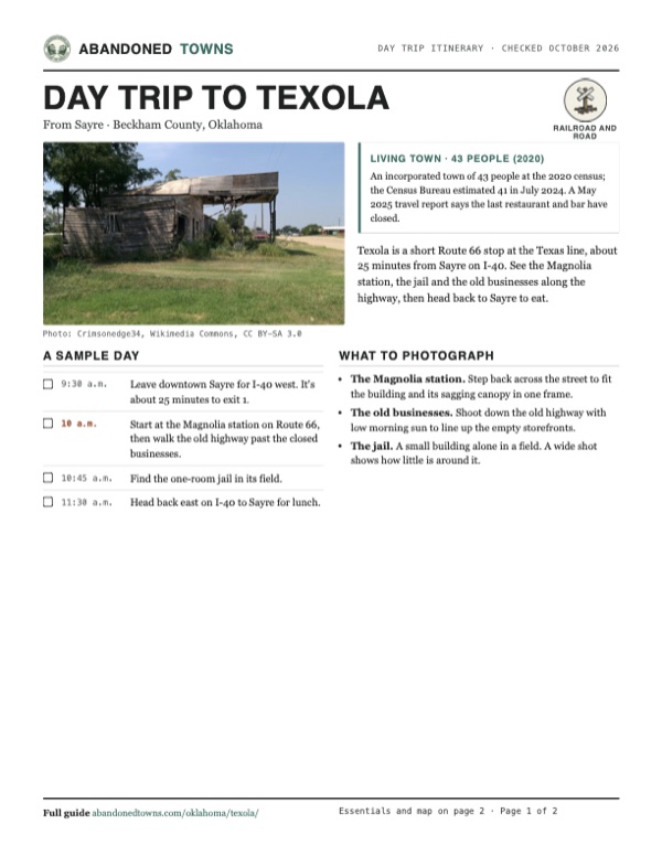
The Magnolia Service Station stands at the southwest corner of Elm Street and Route 66. It was built in 1930, closed for good in the 1980s according to Islands, and was listed on the National Register in 1995. Photos from 2015 show it empty, its wooden canopy sagging. The one-room cinderblock jail, built around 1910 by the same 2025 account, stands deserted in a field, with a memorial to the class of 1939 in front. Along the old highway are derelict businesses, including the former Last Stop Bar and the overgrown Friendly Cafe at Grand Avenue and Route 66.
- Magnolia Service Station (1930, National Register)
- One-room jail
- Former Last Stop Bar
- Former Friendly Cafe
- Empty storefronts and houses
The historic maps below show the town on the state line. The 1955 sheet shows US 66 and the railroad running east from Texola to Erick, and the 1961 sheet shows the street grid on US 66 just south of the railroad, with the highway marked four-lane east of town.


Historic maps
Texola on USGS maps, 1955–1961
Crops from the USGS Historical Topographic Map Collection, centered on the townsite. Each sheet shows what surveyors mapped that year; compare them with today's topo and aerial on this page.

Day trip
Plan a day trip to Texola from Sayre
Take it with you
Day trip itinerary
The essentials, the sample day with boxes to tick, what to photograph and the coordinates, on two printable pages. Handy where there's no signal.
Download the PDF (509 KB)Texola is a short Route 66 stop at the Texas line, about 25 minutes from Sayre on I-40. See the Magnolia station, the jail and the old businesses along the highway, then head back to Sayre to eat.
A sample day
- Leave downtown Sayre for I-40 west. It's about 25 minutes to exit 1.
- Start at the Magnolia station on Route 66, then walk the old highway past the closed businesses.
- Find the one-room jail in its field.
- Head back east on I-40 to Sayre for lunch.
What to photograph and film
- The Magnolia station. Step back across the street to fit the building and its sagging canopy in one frame.
- The old businesses. Shoot down the old highway with low morning sun to line up the empty storefronts.
- The jail. A small building alone in a field. A wide shot shows how little is around it.
Map & directions
Getting there
Texola is at I-40 exit 1, the first exit east of the Texas line. Sayre is the nearest city with services, about 25 minutes east, and downtown Oklahoma City is about 2 hours 40 minutes away.


Base map: USGS The National Map (public domain). Routes: OSRM on © OpenStreetMap contributors data (ODbL), computed October 2026. Times assume dry roads.
- From downtown Sayre, head south on South 4th Street, Business I-40 and US 283.1.9 mi
- Take the ramp and merge onto I-40 west.20.2 mi
- Take exit 1.0.2 mi
- Turn left onto Grand Avenue into Texola.0.4 mi
- From downtown Oklahoma City, take Reno Avenue and Oklahoma City Boulevard to I-40 west.2.7 mi
- Follow I-40 west.147.1 mi
- Take exit 1.0.2 mi
- Turn left onto Grand Avenue into Texola.0.4 mi
Road and safety notes
- Paved interstate to exit 1, then town streets.
- People live in Texola. Look at the empty buildings from the street, and don't go inside.
Photos
Texola in photos
Visitor reports
Been to Texola?
Been there lately? Tell the next visitor what you found: whether you could get in, the state of the road and what's still standing. Photos are welcome. We read every report before it appears here.
Railroad and road
More railroad, road and fort ghost towns
The nearest in Oklahoma.

 Guide
Depew
35.80, -96.51Creek County, Oklahoma
A railroad and oil town that Route 66 passed through for less than two years. The highway moved north in 1928, and Depew's Main Street is now a row…
 Guide
Boggy Depot
34.32, -96.31Atoka County, Oklahoma
A Choctaw and Chickasaw town on the Texas Road, a Butterfield stage stop and a Confederate supply depot. The railroad missed it in 1872. Its…
Nearby
Other sites near Texola
Straight-line distance from the townsite to other mapped sites in our Oklahoma index.
Sources
Sources and credits
- Encyclopedia of Oklahoma History and Culture, "Texola" (Linda D. Wilson, updated 2024): post office, earlier names, Greer and Beckham counties, railroad, newspaper, 1909 businesses, populations 1910–2020, I-40, National Register listing.
- Wikipedia, "Texola, Oklahoma", retrieved October 2026: eight surveys, Route 66 as 5th Street, I-40 completion in 1975, exit 1, jail dates, Magnolia station built in 1930, coordinates.
- National Register of Historic Places, Magnolia Service Station (95000028): location at Elm Street and US 66, Magnolia Petroleum Co., 1930.
- Islands, "Oklahoma's Once-Thriving Town On Route 66" (Rene Bennett, May 31, 2025): 40 residents as of 2023, the last restaurant and bar closed, the jail, the Magnolia station's closing in the 1980s, the Last Stop Bar and Friendly Cafe.
- City and town population estimates for Oklahoma, Vintage 2024, U.S. Census Bureau: July 2024 estimate of 41 for Texola town.
- ghosttowns.com, "Texola": fact-sheet cross-check (county, 2WD roads).
- Commons file pages for each photo: dates and places taken. Elevation: USGS 3D Elevation Program point query. Routes: OSRM on OpenStreetMap data, October 2026.
Photo and map credits
- The Magnolia Service Station, August 2015: Crimsonedge34, Wikimedia Commons, CC BY-SA 3.0
- An old bar on 5th Street, 2008: CTLiotta, Wikimedia Commons, CC0
- Abandoned restaurant and service station, 2023: TheDoctorWho, Wikimedia Commons, CC BY-SA 4.0
- Old Route 66 at sunset, 2011: John Phelan, Wikimedia Commons, CC BY 3.0
- An empty white frame house with a dormer, 2017: Gorup de Besanez, Wikimedia Commons, CC BY-SA 4.0
- A house with a collapsed roof among trees, 2017: Gorup de Besanez, Wikimedia Commons, CC BY-SA 4.0
- A blue house with a columned porch, 2017: Gorup de Besanez, Wikimedia Commons, CC BY-SA 4.0
- Area base map, topo and aerial imagery: USGS The National Map (public domain).
- Historic maps: USGS Historical Topographic Map Collection (public domain): Clinton 1955, 1:250,000; Erick 1961, 1:62,500.