 Abandoned

Overview
Tombstone's railroad stop

In its boom years Tombstone had no railroad, so the nearest stop was here, about nine miles west by road beside the San Pedro River. The camp began in 1881 when the tracks came through, got a station in 1882 and took the name Fairbank on May 16, 1883, the day its post office opened. N. K. Fairbank of Chicago helped pay for the railroad and founded the Grand Central Mining Company, one of Tombstone's big producers. Supplies for Tombstone came in through Fairbank, and ore went out to the mills at Contention City and Charleston.
The town never had many people. There were about 100 in the mid-1880s, with a quartz mill, a store, a butcher, a restaurant, a saloon, a Wells Fargo office and the depot. When Tombstone's mines flooded in 1886, the nearby mills closed and the depot lost business. A rail link to Bisbee's copper mines in 1889 gave Fairbank a second life, and the 1890 census counted 478 people. Sources say three or four railroad lines met here at the peak.
In 1901 the Boquillas Land and Cattle Company bought the old Mexican land grant under the town and evicted would-be landowners, though it leased the mercantile and a few houses well into the 1970s. The last residents left in that decade. The BLM acquired the land in 1986, restored the schoolhouse as a museum in 2007 and stabilized the mercantile in 2019 and 2020.
Timeline
From rail stop to BLM townsite
- A Native American village called Santa Cruz de Gaybanipitea stands near the site.
- The railroad arrives, and the first settlers follow. The camp is called Junction City, then Kendall.
- A railroad station is built, the closest rail stop to Tombstone. The BLM dates the town from this year.
- The town is formally named Fairbank, for Chicago investor N. K. Fairbank, and its post office opens.
- About 100 people, a steam quartz mill, a store, a butcher, a restaurant, a saloon, a Wells Fargo office and the depot.
- Tombstone's mines flood. The nearby mills close and the depot loses most of its business.
- A rail link to Bisbee brings copper traffic through the Fairbank depot.
- The census counts 478 people, the most it ever records. In September a San Pedro flood causes heavy damage.
- The Burt Alvord gang tries to rob the express car of a stopped train. Messenger Jeff Milton drives them off.
- The Boquillas Land and Cattle Company buys the old Mexican land grant under the town and evicts would-be landowners.
- The wooden schoolhouse burns. A gypsum-block school replaces it in 1920 and holds classes until 1944.
- The census counts 269 people.
- The mercantile, the post office and the last homes close, and the town empties.
- The BLM acquires the land grant. Congress creates the San Pedro Riparian National Conservation Area in 1988.
- The BLM finishes restoring the schoolhouse and opens it as a museum.
- Contractors stabilize the mercantile building for the BLM.
February 1900
The train robbery that failed
In February 1900, the Burt Alvord gang tried to rob the express car of the Benson to Nogales train while it stood at Fairbank taking on water. Alvord and his partner Billy Stiles were lawmen who had turned outlaw. Wikipedia dates the attempt to February 15.
The Wells Fargo messenger was Jeff Milton, a former lawman. A bullet shattered his upper left arm, but he drove the gang off, and they left without the gold. One bandit, "Three Fingered Jack" Dunlop, was mortally wounded. He confessed before he died in Tombstone, and others were arrested, among them the outlaw Bill Downing. Milton's arm was saved, and he went on to work as a range detective.
Dunlop is one of the men buried in Tombstone's Boothill.
Retellings add colorful details, such as the line Milton is supposed to have spoken to the surgeon who wanted to amputate. We haven't found a source for those, so we leave them out.
What's left
What you'll see


The townsite sits on the north side of AZ 82, half a mile east of the San Pedro. A short path leads from the gravel parking area to the 1920 schoolhouse, now a museum with a restored classroom, exhibits, flip books and a small shop run by the Friends of the San Pedro River. The long adobe mercantile building held the post office, a general store and a saloon, and it stayed open into the 1970s. Nearby stand a couple of houses, a garage, a chicken coop, a stable and privies. Only foundations remain of the Montezuma Hotel. The other buildings are closed, but signs explain them.
A gravel trail heads north about half a mile to the town cemetery and continues to the ruins of the Grand Central Mill, about 1.25 miles from the trailhead. The trail is nearly flat. The Fairbank Loop Trail and the San Pedro Trail continue along the river.
The historic maps below show Fairbank as a rail junction. The 1915 and 1932 sheets have lines running north toward Benson Junction and Contention, south along the river and east to Tombstone on the El Paso and Southwestern, and the 1915 sheet carries the name of the San Juan de las Boquillas y Nogales land grant across the valley. The 1952 sheet marks ruins, a water tank and a cemetery north of AZ 82, and puts the Fairbank name beside the Southern Pacific tracks to the south.
- Schoolhouse (1920), now a museum
- Adobe mercantile
- Houses, garage, chicken coop, privies
- Stable
- Montezuma Hotel foundations
- Cemetery, about 0.5 mi north
- Grand Central Mill ruins, about 1.25 mi north
- Railroad grades


Historic maps
Fairbank on USGS maps, 1915–1996
Crops from the USGS Historical Topographic Map Collection, centered on the townsite. Each sheet shows what surveyors mapped that year; compare them with today's topo and aerial on this page.

Day trip
Plan a day trip to Fairbank from Tombstone
Take it with you
Day trip itinerary
The essentials, the sample day with boxes to tick, what to photograph and the coordinates, on two printable pages. Handy where there's no signal.
Download the PDF (471 KB)Fairbank is the easiest stop on the San Pedro, with paved road, free entry and a short walk from the car to the buildings. Come Friday to Sunday if you want the schoolhouse museum open. Walk out to the Grand Central Mill in the morning, picnic under the trees, and spend the afternoon in Tombstone, 15 minutes away.
A sample day
- Leave Tombstone. Take AZ 80 northwest and AZ 82 west, about 15 minutes in all.
- The schoolhouse museum opens. See the restored classroom and the exhibits, then walk past the mercantile, the houses and the hotel foundations.
- Take the gravel trail north past the cemetery to the Grand Central Mill, 1.25 miles each way.
- Picnic at the shaded tables by the schoolhouse.
- Drive back to Tombstone. From October to May the courthouse museum is open until 4:30 p.m.
- The Longhorn Restaurant on Allen Street, which the Tombstone Chamber of Commerce calls the town's oldest continually operated restaurant. It's open until 8 p.m.
Coming from Tucson? Allow about 1 hour 25 minutes, and leave by 8 a.m. to arrive at opening.
What to photograph and film
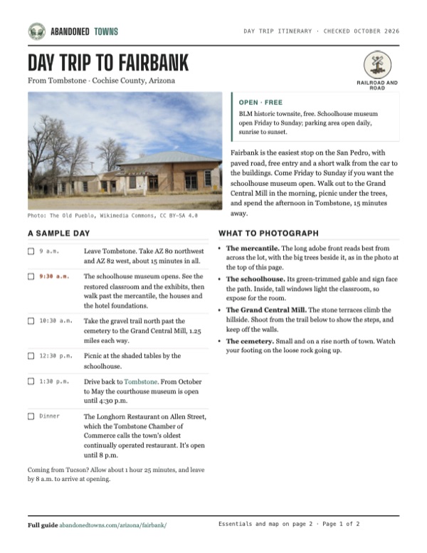
- The mercantile. The long adobe front reads best from across the lot, with the big trees beside it, as in the photo at the top of this page.
- The schoolhouse. Its green-trimmed gable and sign face the path. Inside, tall windows light the classroom, so expose for the room.
- The Grand Central Mill. The stone terraces climb the hillside. Shoot from the trail below to show the steps, and keep off the walls.
- The cemetery. Small and on a rise north of town. Watch your footing on the loose rock going up.
Map & directions
Getting there
Tombstone is the closest town, about 15 minutes away on AZ 80 and AZ 82. From Tucson, the BLM's suggested route runs east on I-10, south on AZ 90 and east on AZ 82. Both are paved, and no high-clearance vehicle is needed. Map apps find the lot as "Fairbank Townsite."


Base map: USGS The National Map (public domain). Routes: OSRM on © OpenStreetMap contributors data (ODbL), computed October 2026. Times assume dry roads.
- From the historic district, take 4th Street to Fremont Street and follow AZ 80 northwest out of town.3.2 mi
- Turn left onto AZ 82 and head west.5.8 mi
- Turn into the Fairbank Historic Townsite lot on the north side of the highway, half a mile before the river.0.1 mi
- From downtown Tucson, take Congress Street to I-10 and head east.44 mi
- Take exit 302 and turn right onto AZ 90. Follow it south toward Huachuca City.19.4 mi
- Turn left onto AZ 82, the Nogales–Tombstone Highway, and head east across the San Pedro River.10.1 mi
- Turn into the Fairbank Historic Townsite lot on the north side of the highway.0.1 mi
Road and safety notes
- AZ 82 is paved, and the BLM says no four-wheel-drive or high-clearance vehicle is needed.
- There's no drinking water on site. Bring plenty, especially for the walk to the mill. There's a vault toilet at the trailhead.
- The San Pedro floods seasonally, and summer monsoon storms are common. Stay out of the washes in a storm.
- Metal detectors are banned, and removing artifacts from public land is illegal.
- Dogs must be leashed at the trailhead and townsite. No camping at the trailhead; backcountry camping needs a BLM permit.
- The BLM notes the river is a travel corridor for people crossing from Mexico. Report anything suspicious and avoid contact.
Photos
Fairbank in photos
Visitor reports
Been to Fairbank?
Been there lately? Tell the next visitor what you found: whether you could get in, the state of the road and what's still standing. Photos are welcome. We read every report before it appears here.
Railroad and road
More railroad, road and fort ghost towns
The nearest in Arizona.

 Guide
Cochise
32.11, -109.92Cochise County, Arizona
A Southern Pacific coal-and-water stop that grew to about 3,000 people and shrank to a few dozen. The old railroad hotel, where Big Nose Kate once…
 Guide
Fort Bowie
32.15, -109.44Cochise County, Arizona
The Army post that guarded Apache Spring for 32 years, through the wars with Cochise and Geronimo. Its adobe ruins are now a free national historic…
Nearby
Other sites near Fairbank
Straight-line distance from the townsite to other mapped sites in our Arizona index.
- Contention City3.3 mi N · Cochise
- Millville6.1 mi S · Cochise
- Charleston6.1 mi S · Cochise
- Tombstone7.1 mi E · Cochise
- Bisbee18.5 mi NE · Cochise
- Gleeson21.1 mi E · Cochise
- Courtland22.5 mi E · Cochise
- Canelo22.9 mi SW · Santa Cruz
Sources
Sources and credits
- ghosttowns.com, "Fairbank": fact sheet fields (roads, legal description, climate, best time, remains, post office opening date).
- Wikipedia, "Fairbank, Arizona", retrieved October 2026: Native village, early names, businesses, census figures, 1889 Bisbee link, 1890 flood, robbery date and outcome, land grant sale, 1986 acquisition, 2007 schoolhouse restoration, coordinates (GNIS).
- BLM, "Fairbank Historic Townsite" (accessibility details updated February 2025): hours, fees, rules, parking, toilet, water, picnic tables, pets, cell reception, trail to the mill, directions, safety notes, founding and naming, as of October 19, 2026.
- BLM, "Restored Fairbank Mercantile beckons visitors" (December 2020): mercantile stabilization, other surviving buildings, schoolhouse fire and rebuilding, four railroad lines.
- Legends of America, "Fairbank, Arizona: Dead in the Desert": the robbery and Milton's wound, school years, post office closing, three railroad lines, hotel foundations, cemetery and mill trail.
- BLM, San Pedro Riparian National Conservation Area: 1988 designation, camping permits.
- Wikimedia Commons, "Grave of Three Fingered Jack Dunlop": photo of Dunlop's marker in Boothill Graveyard, Tombstone.
- Friends of the San Pedro River, public events calendar: free Saturday history walks at Fairbank (November 7, 2026), Millville (November 14) and the Grand Central Mill (November 28), with meeting points, distances, trail conditions, shade and the Millville trailhead vault toilet, as of October 2026.
- Arizona State Parks, Tombstone Courthouse State Historic Park: daily hours by season, as of October 2026.
- The Longhorn Restaurant, official site, and the Tombstone Chamber of Commerce listing: Allen Street location, oldest continually operated restaurant in town, opening hours, as of October 2026.
- Elevation: USGS 3D Elevation Program point query. Routes: OSRM on OpenStreetMap data, October 2026.
Photo and map credits
- The adobe mercantile, open until the 1970s: The Old Pueblo, Wikimedia Commons, CC BY-SA 4.0
- Fairbank around 1890: Unknown. 19th Century Photo (1890)., Wikimedia Commons, Public domain
- The schoolhouse, built in 1920: Bureau of Land Management, Wikimedia Commons, Public domain
- The restored classroom: Bureau of Land Management, Wikimedia Commons, Public domain
- Exhibits inside the schoolhouse: BLMArizona, Wikimedia Commons, Public domain
- Ruins of the Grand Central Mill: maarit u, Wikimedia Commons, CC BY 3.0
- The trail to the mill: BLMArizona, Wikimedia Commons, Public domain
- Frame houses and the schoolhouse, 2014: The Old Pueblo, Wikimedia Commons, CC BY-SA 4.0
- Picnic tables on an old store foundation: The Old Pueblo, Wikimedia Commons, CC BY-SA 4.0
- Topo map, area base map and aerial imagery: USGS The National Map (public domain).
- Historic maps: USGS Historical Topographic Map Collection (public domain): Benson 1915, 1:125,000; Fairbank 1932, 1:62,500; Benson 1943, 1:125,000; Fairbank 1952, 1:24,000; Fairbank 1996, 1:24,000.