 Abandoned

Overview
The mill half of a twin town

Tombstone had silver but no water to mill it, so its ore went by mule train about nine miles southwest to the San Pedro River. In June 1879 Richard Gird and the Schieffelin brothers, Ed and Al, started a 10-stamp mill on the east bank for their Tombstone Mill and Mining Company. The Corbin Mill and Mining Company built a second mill beside it. The settlement around the mills was Millville, and it had its own post office from May 1879.
The people who worked the mills mostly lived across the river in Charleston, which had the stores, the school and the saloons, and a bridge joined the two. Millville's post office closed after a year, but the mills ran day and night. In their best year, 1881–82, they produced between $1.3 million and almost $1.4 million in silver bullion, depending on the source.
When Tombstone's mines flooded in 1886, the mills shut down. The 1887 earthquake wrecked Charleston's adobe buildings, and by 1889 both towns were empty. The mill site is now public land in the San Pedro Riparian National Conservation Area. Unlike Charleston, it has a trail, and the walk to the ruins is short.
Timeline
Ten years of milling
- A post office opens at Millville, on the east bank of the San Pedro.
- The Tombstone Mill and Mining Company of Richard Gird and Ed and Al Schieffelin starts its 10-stamp mill. Ore comes by mule train from Tombstone, about nine miles away.
- The Corbin Mill and Mining Company builds a second mill beside the first. Sources date its start to 1879 or 1880.
- Millville's post office closes. The mill hands live across the river in Charleston, which keeps its own office.
- The best years. The mills run day and night, and in their peak year turn out $1.3 million to almost $1.4 million in silver bullion, depending on the source.
- A robbery attempt on the Tombstone Mining Company at Millville fails, and mining engineer M. R. Peel is killed.
- Tombstone's mines flood and the mills shut down. One account says the Gird mill moved to Tombstone while the Corbin mill worked the last ore.
- The Sonoran earthquake leaves Charleston's adobe buildings in ruins.
- Millville and Charleston are both empty.
- USGS maps print the name Charleston on the east bank, beside the old mill buildings at Millville.
- Congress creates the San Pedro Riparian National Conservation Area. The BLM manages the mill site as the Millville Historic Townsite.
Legend and record
Which town is which

Charleston and Millville faced each other across the river, and the record often blurs them. The federal names database, GNIS, has no entry for Millville. Its point for "Charleston (historical)" falls on the east bank, among the Millville ruins. Our point for this page is about 90 meters from it, in the middle of the mill terraces on aerial imagery. The old USGS maps do the same thing. The 1915, 1932 and 1952 sheets at 1:125,000 and 1:62,500 print the name Charleston on the east bank beside a few buildings. The 1952 Fairbank sheet at 1:24,000 is the first to separate them, with an outline marked "Ruins" west of the river for Charleston and three more "Ruins" labels on the east bank where the mills stood.
Even the ruins have two names. Arizona Highways calls the ruin at the overlook the Corbin mill; Archaeology Southwest and a 2011 photo on Wikimedia Commons call the stone walls Gird's mill.
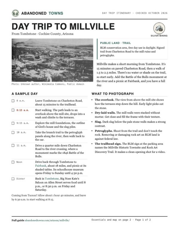
The two mills stood side by side, so both can be right, and we haven't seen a site plan that settles which wall belongs to which company. The panorama at the top of this page has the same problem with its date. The Commons file is named 1880, its description says 1879, and Archaeology Southwest uses both.
Charleston's reputation for lawlessness, and the stories about its justice of the peace, belong to the town across the river. The robbery attempt of March 1882 did happen at Millville. It failed, and it cost the engineer M. R. Peel his life.
What's left
Foundations, slag and rock art


An easy path from the parking area leads to an overlook above the mill site. From there the trail drops into a wash and climbs to the ruins. The mills were built into the hillside, and their stacked-stone foundations and retaining walls still step down the slope. Nearby are the outline of Richard Gird's house, which also served as the Tombstone Mill and Mining Company office, big piles of waste rock and slag, and signs with historic photos. Much of the site has been picked over by looters.
A branch of the trail network leads to petroglyph panels along the river, far older than the mills. It's about 1.5 miles round trip to the ruins and 2.5 miles to see both. A quarter mile down Charleston Road, at the river crossing, a monument marks the 1846 Battle of the Bulls, when wild cattle charged the Mormon Battalion on its march to San Diego.
On the historic maps below, the 1952 Fairbank sheet shows the mill site best: three ruins on the slope east of the railroad and a long embankment beside the tracks. By 1996 the ruin labels are gone, but the embankment is still drawn.
- Stacked-stone mill foundations
- Hillside retaining walls
- Outline of Gird's house and company office
- Waste-rock and slag piles
- Embankment beside the old rail line
- Petroglyph panels
- Interpretive signs
- Charleston ruins across the river (no trail)


Historic maps
Millville on USGS maps, 1915–1996
Crops from the USGS Historical Topographic Map Collection, centered on the townsite. Each sheet shows what surveyors mapped that year; compare them with today's topo and aerial on this page.

Day trip
Plan a day trip to Millville from Tombstone
Take it with you
Day trip itinerary
The essentials, the sample day with boxes to tick, what to photograph and the coordinates, on two printable pages. Handy where there's no signal.
Download the PDF (454 KB)Millville makes a short morning from Tombstone. It's 15 minutes on paved Charleston Road, then a walk of 1.5 to 2.5 miles. There's no water or shade on the trail, so start early. Add the Battle of the Bulls monument at the river and a picnic at Fairbank, and you have a full day.
A sample day
- Leave Tombstone on Charleston Road, about 15 minutes to the trailhead.
- Start walking. The path leads to an overlook above the mill site, drops into a wash and climbs to the terraces.
- Explore the mill foundations, the outline of Gird's house and the slag piles.
- Take the branch trail to the petroglyph panels along the river, then walk back to the car.
- Drive a quarter mile down Charleston Road to the river crossing, where a monument marks the 1846 Battle of the Bulls.
- Drive back through Tombstone to Fairbank, about 18 miles, and picnic at its shaded tables. Its schoolhouse museum opens Friday to Sunday until 4:30 p.m.
- Back in Tombstone, Big Nose Kate's Saloon on Allen Street serves food until 8 p.m., or 8:30 p.m. on Friday and Saturday.
Coming from Tucson? Allow about 1 hour 40 minutes, and leave by 6:30 a.m. to start walking at 8:15.
What to photograph and film
- The overlook. The view from above the mill site shows how the terraces step down the hill. Early light picks out the stone.
- Dry-laid walls. The mill walls were stacked without mortar. Get close and fill the frame with their texture.
- Slag. Dark slag below the pale stone walls makes a strong contrast.
- Petroglyphs. Shoot from the trail and don't touch the rock. Removing or damaging rock art on BLM land is against federal law.
- The trailhead sign. The BLM sign at the parking area names the Millville Historic Townsite and Rock Art Discovery Trail. It makes a clean opening shot for a video.
Map & directions
Getting there
Tombstone is the closest town, nine miles away on paved Charleston Road. From Tucson, the fastest route runs down AZ 90 past Sierra Vista and east on Charleston Road. Both routes end at the BLM trailhead parking area just east of the river.


Base map: USGS The National Map (public domain). Routes: OSRM on © OpenStreetMap contributors data (ODbL), computed October 2026. Times assume dry roads.
- From the historic district, take Toughnut Street west and turn left on Sumner Street.0.4 mi
- Sumner Street becomes Charleston Road. Follow it southwest toward the San Pedro River.8.4 mi
- Turn right into the Millville trailhead parking area, about a quarter mile before the river bridge.0.1 mi
- From downtown Tucson, take Congress Street to I-10 and head east.44 mi
- Take exit 302 and turn right onto AZ 90. Follow it south through Huachuca City toward Sierra Vista.28 mi
- Turn left onto the AZ 90 Bypass.4.2 mi
- Turn left on Charleston Road and follow it east across the San Pedro River. The trailhead parking area is on the left about a quarter mile past the bridge.7.8 mi
Road and safety notes
- Charleston Road is paved from Tombstone and Sierra Vista. The trailhead is on the north side of the road, a quarter to half a mile east of the river.
- The trail is short but drops into a wash and climbs back out. Carry water, especially from May to September.
- There's no trail to the Charleston ruins across the river, and the BLM doesn't encourage visits there.
- Day use is free and limited to daylight. Overnight backcountry camping needs a BLM permit, $2 per person per night.
- The San Pedro floods in summer monsoon storms. Stay out of the riverbed and washes when it rains.
- Leave artifacts, slag and rock art as you find them. Removing or damaging them on BLM land is against federal law.
Photos
Millville in photos
Visitor reports
Been to Millville?
Been there lately? Tell the next visitor what you found: whether you could get in, the state of the road and what's still standing. Photos are welcome. We read every report before it appears here.
Silver mining
More silver mining ghost towns
The nearest in Arizona.

 Guide
Charleston
31.63, -110.18Cochise County, Arizona
The town where Tombstone's silver was milled, on the west bank of the San Pedro. An earthquake finished it in 1887. A few adobe walls survive in the…
 Guide
Tombstone
31.71, -110.07Cochise County, Arizona
Arizona's richest silver district and the scene of the 1881 gunfight near the O.K. Corral. The mines flooded and the census count fell to 646 by…
Nearby
Other sites near Millville
Straight-line distance from the townsite to other mapped sites in our Arizona index.
- Charleston0.3 mi W · Cochise
- Fairbank6.1 mi N · Cochise
- Tombstone8.1 mi NE · Cochise
- Contention City9.3 mi N · Cochise
- Bisbee19.4 mi SE · Cochise
- Sunnyside19.6 mi SW · Cochise
- Bisbee21.2 mi NE · Cochise
- Canelo21.2 mi W · Santa Cruz
Sources
Sources and credits
- ghosttowns.com, "Millville": fact sheet fields (road, legal description, climate, best time, remains, post office dates). It prints the township as T21N; the 1996 USGS sheet shows T21 South.
- Wikipedia, "Charleston, Arizona" ("Millville, Arizona" redirects there), retrieved October 2026: the two mill companies, post office dates, bullion figure, 1880 census, the Peel killing, the earthquake, abandonment, BLM management.
- Archaeology Southwest, "Charleston and Millville Sites": Millville on the east bank, decline from 1886, empty by 1889, BLM management, daylight hours and no fee, the "Gird's Mill" caption and photo dates.
- AZ Offroad, "Millville" (2023): the 10-stamp mill of June 1879, the Corbin mill by 1880, mule trains from Tombstone, the bridge to Charleston, the 1881 bullion figure, the Gird mill's move, trailhead parking and toilets, the 1.5-mile round trip, foundations, Gird house, slag and looting.
- Arizona Highways, "Charleston Road": pullout at about mile 8.5 from Tombstone, the Corbin mill overlook, mills running 24 hours a day, petroglyph panels, 2.5-mile round trip, the Battle of the Bulls monument, no trail to Charleston.
- BLM, San Pedro Riparian National Conservation Area: Charleston Road access to the Millville Historic Townsite, free day use, camping permits and fees, office phone, as of October 2026. BLM, Fairbank Historic Townsite: flooding and monsoon warnings for the conservation area and the ban on removing artifacts.
- Wikipedia, "San Pedro Riparian National Conservation Area": designation date.
- Friends of the San Pedro River, public events calendar: free Saturday history walks at Fairbank (November 7, 2026), Millville (November 14) and the Grand Central Mill (November 28), with meeting points, distances, trail conditions, shade and the Millville trailhead vault toilet, as of October 2026.
- BLM, "Fairbank Historic Townsite": parking hours, schoolhouse museum days and hours, fees, vault toilet, no drinking water, shaded picnic tables, the 1.25-mile trail to the Grand Central Mill, pets, metal detectors, cell reception, as of October 2026.
- Big Nose Kate's Saloon, official site: Allen Street location, saloon and kitchen hours, as of October 2026.
- USGS Historical Topographic Map Collection: Benson 1915, Fairbank 1932, Fairbank 1952 (1:24,000), Tombstone 1952 and Fairbank 1996 sheets, for the ruins, embankment, name placement and township. Coordinates: the mill terraces on USGS The National Map aerial imagery, about 90 m from GNIS "Charleston (historical)" (feature ID 24360), checked against the 1952 sheet and the OpenStreetMap Millville Trail. Trailhead: OpenStreetMap. Elevation: USGS 3D Elevation Program. Routes: OSRM on OpenStreetMap data, October 2026.
Photo and map credits
- Millville about 1880: the mills, ore trestles and a long veranda house: Unknown author, Wikimedia Commons, Public domain
- Stone walls at the mill site, described on Commons as Gird's mill, 2011: StellarD, Wikimedia Commons, CC BY-SA 3.0
- Dark slag and rubble below a stone mill wall: Bureau of Land Management (BLM) Arizona, Wikimedia Commons, Public domain
- A dry-laid stone wall among the mesquite: Bureau of Land Management (BLM) Arizona, Wikimedia Commons, Public domain
- The BLM sign at the trailhead on Charleston Road: BLMArizona, Wikimedia Commons, Public domain
- A petroglyph boulder above the river corridor: Bureau of Land Management (BLM) Arizona, Wikimedia Commons, Public domain
- A petroglyph panel with a wavy line: Bureau of Land Management (BLM) Arizona, Wikimedia Commons, Public domain
- The 1952 Fairbank sheet, with "Ruins" on both banks: U.S. Geological Survey, USGS catalog, Public domain
- Topo map, area base map and aerial imagery: USGS The National Map (public domain).
- Historic maps: USGS Historical Topographic Map Collection (public domain): Benson 1915, 1:125,000; Fairbank 1932, 1:62,500; Fairbank 1952, 1:24,000; Tombstone 1952, 1:62,500; Fairbank 1996, 1:24,000.