 Abandoned
Overview
Twenty years of sandstone

Banning lived and died with its quarry. In 1892 the St. Paul and Duluth Railroad laid a spur to a sandstone outcrop on the Kettle River, upstream from Sandstone, and quarrying began. The Great Hinckley Fire of 1894 set it back, but work resumed quickly, and about two years later a town grew up beside the quarry. It took the name of William L. Banning, a railroad contractor and politician who had been president of the St. Paul and Duluth. The post office opened in 1896.
KROC News lists a bar, a boarding house and some homes. Counts of its people differ: the 1910 census found 149, and a WCCO report quoted by KROC News in 2025 put the peak at about 300. Workers cut the pinkish stone into blocks and shipped it by rail. The Grand Forks Herald, writing in 2021, credits the park's quarries with the stone for Pillsbury Hall at the University of Minnesota and the downtown Minneapolis courthouse.
By 1905 the best stone was gone and builders had turned to steel. An asphalt company hung on until 1912, and when it closed the town closed too. The post office shut that year, the railroad pulled its tracks later in the decade, and the 1920 census found 44 people. In 1959 the Pine County Historical Society asked the state to save the ghost town as a historic site, and in 1963 it became the heart of Banning State Park. Wikipedia says the town itself is no longer visible. What you can see are the quarry walls and the roofless stone buildings of the quarry works.
Video
A summer walk on the Quarry Loop
Two hikers walk the Quarry Loop on a green summer day, with side trips to Wolf Creek Falls and the Hell's Gate rapids. They pass the roofless concrete and stone walls of the quarry buildings, covered in graffiti, quarried rock faces and piles of fallen blocks, an interpretive sign, glacial potholes in the riverside sandstone, and a small ruin the narration calls the powder house. Kayakers run the rapids below. The narration gives the loop as 2.5 miles, where the Grand Forks Herald says under two; it also credits Banning stone to the Capitol dome and other buildings, shown with borrowed stills, which our sources don't confirm. The hikers scramble on the river ledges and ask viewers to be very cautious.
 Play “Banning’s Quarry Loop Trail: The Hike That Kept Going” from YouTube
Timeline
Quarry, town and park

- Quarrying starts on the Kettle River after the St. Paul and Duluth Railroad lays a spur to the sandstone outcrop.
- The Great Hinckley Fire sets the quarry back. Work resumes quickly.
- A town grows up just outside the quarry, named Banning for William L. Banning, a railroad contractor and former president of the St. Paul and Duluth. Its post office opens the same year.
- The boom is over. Most of the easily quarried good stone is gone, and builders have turned from stone to structural steel.
- The census counts 149 people.
- An asphalt company, the last business, closes, and the town closes with it. The post office closes the same year.
- The railroad takes up its tracks.
- The census counts 44 people.
- The Pine County Historical Society interests the state in the ghost town as a historic site. The idea grows into a state park.
- The legislature establishes Banning State Park.
- A dam at the park's southern tip is removed, restoring a waterfall and rapids.
What's left
Walls along the Quarry Loop

The ruins are on the Quarry Loop, a self-guided trail that the Grand Forks Herald in 2021 called less than two miles long and relatively flat. In some spots, it said, a few buildings and the foundations of others remain. The park manager told WCCO that drill holes can still be seen in some of the rock.
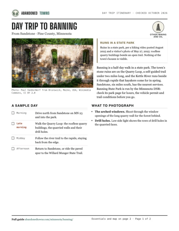
Photos on Wikimedia Commons show what that means. In August 2019 a visitor photographed the long wall of one quarry building, three arched window openings and a coat of graffiti. In May 2025 another walked the trail between two roofless stone buildings. Quarried faces stand above the river, and the trail runs along the Kettle River bluffs.
The 1961 Sandstone sheet below prints Banning on a road east of Wolf Creek and the word Ruins just below it, near the river. The current USGS map still labels Banning there, with Hells Gate Rapids on the Kettle just downstream and the park trails around it.
- Roofless sandstone buildings of the quarry works
- Quarry walls with drill holes
- Foundations along the Quarry Loop
- Hells Gate rapids on the Kettle River


Historic maps
Banning on USGS maps, 1961
Crops from the USGS Historical Topographic Map Collection, centered on the townsite. Each sheet shows what surveyors mapped that year; compare them with today's topo and aerial on this page.

Day trip
Plan a day trip to Banning from Sandstone
Take it with you
Day trip itinerary
The essentials, the sample day with boxes to tick, what to photograph and the coordinates, on two printable pages. Handy where there's no signal.
Download the PDF (530 KB)Banning is a half-day walk in a state park. The town's stone ruins are on the Quarry Loop, a self-guided trail under two miles long, and the Kettle River runs beside it through rapids that kayakers come for in spring. Sandstone, six miles south, has the nearest services. Banning State Park is run by the Minnesota DNR: check its park page for hours, the vehicle permit and trail conditions before you go.
A sample day
- Drive north from Sandstone on MN 23 and into the park.
- Walk the Quarry Loop: the roofless quarry buildings, the quarried walls and their drill holes.
- Follow the river trail to the rapids, staying back from the edge.
- Return to Sandstone, or ride the paved spur to the Willard Munger State Trail.
What to photograph and film
- The arched windows. Shoot through the window openings of the long quarry wall for the forest behind.
- Drill holes. Low side light shows the rows of drill holes in the quarried faces.
Map & directions
Getting there
Sandstone is the nearest town with services, about six miles south. From the Twin Cities, I-35 runs north past Sandstone to the MN 23 exit, and the park entrance is just east of the freeway.

Base map: USGS The National Map (public domain). Routes: OSRM on © OpenStreetMap contributors data (ODbL), computed October 2026. Times assume dry roads.
- From downtown Sandstone, take County Highway 64, which becomes Oak Street.0.4 mi
- Continue on MN 23, signed with County 61 at first.3.1 mi
- Keep right on MN 23.0.8 mi
- Turn right on the park road.0.5 mi
- At the end of the road, turn right, then right again.1.1 mi
- From downtown Minneapolis, take South 4th Street and Washington Avenue South to I-35W north.0.9 mi
- Follow I-35W north.28.3 mi
- Continue on I-35 north.63.2 mi
- Leave the freeway and turn right on MN 23.0.5 mi
- Turn right on the park road, turn right at its end, then right again.1.6 mi
Road and safety notes
- The Grand Forks Herald gives the park's freeway exit as Exit 195 on I-35, barely a mile from the park.
- The route ends on the park road about 220 m from the GNIS point for the townsite. The Quarry Loop starts in the park.
- A sign on the river trail, photographed in 2017, warns of very dangerous rapids for the next two miles.
Photos
Banning in photos
Visitor reports
Been to Banning?
Been there lately? Tell the next visitor what you found: whether you could get in, the state of the road and what's still standing. Photos are welcome. We read every report before it appears here.
Other mining and oil
More lead, iron, mercury and oil ghost towns
The nearest in Minnesota.

 Guide
Manganese
46.53, -94.01Crow Wing County, Minnesota
A village platted in 1911 on the Cuyuna Range's manganese ore. It reached nearly 600 people in 1919, emptied as the mines closed, and was dissolved…
 Guide
Elcor
47.51, -92.44St. Louis County, Minnesota
A company town of the Elba and Corsica mines that held nearly 1,000 people around 1920. Its owner ordered everyone out in 1955, and since 1993 the…
Nearby
Other sites near Banning
Straight-line distance from the townsite to other mapped sites in our Minnesota index.
Sources
Sources and credits
- Wikipedia, "Banning, Minnesota", retrieved October 2026: the post office of 1896 to 1912, the naming for William L. Banning, the 1910 and 1920 census counts, the GNIS coordinates.
- Wikipedia, "Banning State Park", retrieved October 2026: quarrying from 1892 on the railroad spur, the 1894 fire, the town two years later, the end of the boom by 1905, the asphalt company and the town closing in 1912, the tracks removed, the Pine County Historical Society in 1959, the park in 1963, the 1995 dam removal, Hell's Gate, the trail mileages, the town remains no longer visible.
- Carly Ross, "How a Ghost Town Became a Minnesota State Park," KROC News, updated January 19, 2025: the naming for the St. Paul and Duluth president, the peak of about 300 per WCCO, the bar, boarding house and homes, the standing walls and the drill holes the park manager pointed out.
- Jess Myers, "Minnesota's Backyard: Waterfalls, whitewater and a historic quarry site compel a stop at Banning State Park," Grand Forks Herald, June 3, 2021: the Quarry Loop under two miles and relatively flat, the buildings and foundations that remain, quarrying from 1892 to 1912, Pillsbury Hall and the Minneapolis courthouse, Exit 195 on I-35, the Munger trail spur.
- SkyGra, "Banning State Park," Wikimedia Commons, photographed May 27, 2025: the walls standing beside the trail.
- Paul VanDerWerf, "Banning Quarry," Wikimedia Commons, photographed August 9, 2019: the quarry building wall.
- Tzumi Woods, "Banning’s Quarry Loop Trail: The Hike That Kept Going", YouTube, posted August 15, 2025: the video on this page; the ruins along the open Quarry Loop (the newest dated report).
- Historic map: USGS 1:62,500 Sandstone sheet, 1961. Elevation: USGS 3D Elevation Program point query. Routes: OSRM on OpenStreetMap data, October 2026.
Photo and map credits
- The long wall of a quarry building, August 2019: Paul VanDerWerf from Brunswick, Maine, USA, Wikimedia Commons, CC BY 2.0
- The trail between two roofless quarry buildings, May 2025: SkyGra, Wikimedia Commons, CC0
- A quarried sandstone face above the river, June 2017: Tony Webster from Minneapolis, Minnesota, United States, Wikimedia Commons, CC BY-SA 2.0
- Sandstone ledges on the Quarry Loop Trail, June 2017: Tony Webster from Minneapolis, Minnesota, United States, Wikimedia Commons, CC BY-SA 2.0
- "Warning: Very Dangerous Rapids, Next 2 Miles," on the Kettle River, September 2017: Tony Webster from Minneapolis, Minnesota, United States, Wikimedia Commons, CC BY-SA 2.0
- The Kettle River running over sandstone ledges in the park, June 2017: Tony Webster from Minneapolis, Minnesota, United States, Wikimedia Commons, CC BY-SA 2.0
- Topo map, area base map and aerial imagery: USGS The National Map (public domain).
- Historic maps: USGS Historical Topographic Map Collection (public domain): Sandstone 1961, 1:62,500.